Mori Atlas logo
Wildlife reserveRich Hole Wilderness

Explore the rugged Brushy Mountain terrain, deep drainage hollows, and virgin timber of this protected forest landscape.

Rich Hole Wilderness: A Protected Appalachian Wildlife Reserve in Western Virginia

Rich Hole Wilderness occupies a compact, ecologically significant portion of Brushy Mountain in western Virginia. This protected landscape is defined by steep, ridge and hollow topography that supports old growth cove hardwood forests and diverse Appalachian wildlife habitats. Within its mapped boundaries, the area preserves narrow drainage basins that have remained largely undisturbed, offering a quiet, forest-dominant wilderness environment near major regional transportation corridors.

wilderness areaAppalachian forestcove hardwood forestold-growth forestnational natural landmarknational forest

Rich Hole Wilderness

Wildlife reserve

Park overview

Structured park overview, official facts, and landscape profile for Rich Hole Wilderness

Rich Hole Wilderness park facts, protected area profile, and essential visitor context

Review the core facts for Rich Hole Wilderness, including designation, size, terrain, visitor scale, habitats, and operating context in one park-focused overview.

About Rich Hole Wilderness

Rich Hole Wilderness lies in the rugged western foothills of Virginia, in the broad sweep of the Appalachian Mountains that run through the central part of the state. It sits roughly sixteen miles west of Lexington, Virginia, just off Interstate 64, within the James River Ranger District of the George Washington and Jefferson National Forests. The wilderness covers approximately 6,450 acres of steep, forested terrain on Brushy Mountain, with elevations climbing from about 1,500 feet along its streams to roughly 3,500 feet along its ridge crests.

The defining identity of Rich Hole is its forest. A 1,326-acre parcel within Rockbridge County was dedicated as a National Natural Landmark in 1974 and is described by the National Park Service as an outstanding example of a cove hardwood forest, a well-protected watershed containing a virgin forest with remarkably large trees of several species. Within the wilderness, particularly along a stream corridor, notable old-growth stands include large white ash and northern red oak, making the area ecologically distinctive within Virginia's national forest system.

The topography of Rich Hole defines the experience of the area. The wilderness is named after the deep drainage hollows in Brushy Mountain, and the principal streams of Rich Hole, including the North Branch of Simpson Creek and Alum Creek, descend through steep forested valleys. These streams are tributaries of the Calfpasture River, which flows eastward to the James River and ultimately the Chesapeake Bay, placing Rich Hole within a much larger mid-Atlantic watershed.

Recreation in Rich Hole Wilderness is low-key and dispersed. There are no loop trails within the wilderness boundaries, and hiking is mostly limited to short day hikes, vehicle-shuttle traverses, or out-and-back routes. The principal footpath, the Rich Hole Trail, runs about 5.5 miles through the heart of the wilderness, climbing very steeply from its northern trailhead before descending gradually to the south, with several stream crossings that can make spring travel difficult. A second trail along the southern boundary follows the old roadbed leading toward a former fire tower site atop Mill Mountain. Hunting is widely regarded as the most common activity in the area, and wildlife species typical of the central Appalachians remain well represented.

Protection and recognition

Documented terrestrial protection metrics and established conservation history

Rich Hole Wilderness Protection Status and Designation History

Rich Hole Wilderness maintains a documented terrestrial protection status established in the designated year 1988. Review the official conservation history, management scope, and verified recognition records associated with this protected area.

Protection details

Protection scope
Terrestrial
Designated year
1988
Transboundary protection
No
Park context

Deeper park guide and search-rich context for Rich Hole Wilderness

Rich Hole Wilderness history, landscape, wildlife, and travel context

Explore Rich Hole Wilderness through its history, landscape character, ecosystems, wildlife, conservation priorities, cultural context, and seasonal travel timing in a structured park guide built for atlas discovery and search intent.

Why Rich Hole Wilderness stands out

Rich Hole Wilderness is best known for its old-growth cove hardwood forest, including a stream-bottom stand of large white ash and northern red oak trees that helped earn part of the area a National Natural Landmark designation in 1974. The wilderness is equally recognized for the rugged Brushy Mountain terrain and the steep hollow drainages from which it takes its name. Although small in size, the combination of virgin hardwood timber, Appalachian wildlife such as black bear and white-tailed deer, and an easily accessible western Virginia location has given Rich Hole a reputation as a high-quality example of mid-Appalachian wilderness.

Rich Hole Wilderness history and protected-area timeline

The lands that now make up Rich Hole Wilderness were first recognized for their wild character decades before formal wilderness designation. In 1958, an inspection team from the Wilderness Society evaluated the area and recommended its suitability as a wilderness based almost exclusively on the unusually robust black bear population inhabiting the rugged drainages of Brushy Mountain. Long before that, the watershed's virgin hardwood forest had drawn scientific attention: in 1974, the National Park Service recognized 1,326 acres within Rockbridge County as a National Natural Landmark for its outstanding example of cove hardwood forest.

Formal wilderness designation came much later. The Virginia Wilderness Act of 1984 directed the Environmental Protection Agency and the State of Virginia to study the effects of proposed development on the air quality of four candidate areas, including Rich Hole. After this review and with the support of the Virginia congressional delegation, Rich Hole was formally designated as wilderness in 1988 under P.L. 100-326, alongside other Virginia areas. Since that time, the area has been administered by the U.S. Forest Service as part of the George Washington and Jefferson National Forests.

Since designation, the Forest Service has periodically evaluated whether to expand the wilderness. In 2009, a proposed revision to the George Washington National Forest plan considered adding acreage along Rich Hole's western boundary. The proposed addition was described by the Forest Service as an opportunity to enlarge a small existing wilderness and to nearly connect Rich Hole Wilderness to the adjacent Rough Mountain Wilderness, although such additions have remained proposals rather than completed expansions.

Rich Hole Wilderness landscape and geographic character

Rich Hole Wilderness occupies a portion of Brushy Mountain in the western Virginia Appalachians, a landscape shaped by long erosion of folded sedimentary ridges into steep, narrow valleys. The wilderness sits roughly sixteen miles west of Lexington, Virginia, with its eastern edge accessible from corridors near Interstate 64. Terrain within the area climbs from approximately 1,500 feet along the lower stream hollows to about 3,500 feet on the highest ridges, a vertical range of around two thousand feet compressed into a small footprint.

The name Rich Hole comes from the deeply incised drainage hollows of Brushy Mountain, of which the North Branch of Simpson Creek and Alum Creek are the principal examples. These drainages descend through steep, narrow valleys, creating the kind of sheltered, well-watered microclimate that supports cove hardwood forest. The streams are tributaries of the Calfpasture River, which flows generally eastward to the James River and ultimately the Chesapeake Bay, tying Rich Hole into a much larger Atlantic watershed.

The ridge-and-hollow topography dominates the visitor experience. Trails within the wilderness climb sharply out of the hollows and traverse long stretches of forested ridge, with multiple small stream crossings along the southern portions of the main trail. The combination of steep gradients, narrow valleys, dense forest cover, and exposed ridgelines defines the physical geography of Rich Hole and explains both its evocative name and its relatively wild character despite proximity to a major highway corridor.

Rich Hole Wilderness ecosystems, habitats, and plant life

The vegetation of Rich Hole Wilderness is shaped by the cool, moist conditions that develop in its deep mountain hollows. The defining ecological feature of the wilderness is its cove hardwood forest, a forest type that thrives in protected, well-watered Appalachian valleys where deep soils and stable microclimates allow sensitive hardwood species to grow to large sizes and great age. A portion of Rich Hole within Rockbridge County was designated a National Natural Landmark in 1974 specifically because of this forest community.

Within these sheltered coves, the wilderness supports a stand of old-growth white ash alongside northern red oak, including mature specimens of remarkable size along one of the principal stream corridors. The surrounding ridges and slopes carry a more typical Appalachian mixed hardwood and mixed oak forest cover, giving the wilderness a layered vegetation pattern grounded in topography, moisture, and soil depth rather than in sharp ecological boundaries.

Because of its relatively undisturbed forest cover and its functioning watershed condition, Rich Hole Wilderness preserves a representative example of central Appalachian cove hardwood ecology. The combination of virgin timber, intact stream systems, and the absence of significant roads or development within the wilderness boundaries gives the area meaningful ecological continuity within a national forest landscape that is otherwise shaped by a long history of timber harvest and rural land use.

Rich Hole Wilderness wildlife and species highlights

Wildlife has been central to the identity of Rich Hole Wilderness since long before it was formally protected. In 1958, a Wilderness Society inspection team evaluating the area concluded that it was suitable as a wild area largely because of its unusually strong black bear population, and bear have remained a hallmark species of the wilderness.

Today, Rich Hole supports the wildlife communities typical of mid-elevation Appalachian hardwood forests. White-tailed deer are widespread through the hollows and ridges, and black bear continue to use the area as part of their broader range across the George Washington and Jefferson National Forests. Wild turkey are present in the mixed forest and edge habitat, and grouse occupy the more brushy portions of the woodland. Smaller mammals typical of eastern hardwood forests, including eastern gray squirrel, raccoon, beaver, and eastern cottontail rabbit, are also part of the wildlife community.

The largely forested and lightly disturbed character of the wilderness, combined with its intact watershed, gives Rich Hole useful habitat value for species that favor extensive unfragmented forest. The presence of old-growth trees along the stream corridors additionally provides cavity and mast resources that support a variety of bird and mammal species, even though the formal record of wildlife sightings within the small wilderness footprint is relatively limited.

Rich Hole Wilderness conservation status and protection priorities

Rich Hole Wilderness matters for conservation primarily because of the integrity of its forest and watershed rather than its size. The wilderness protects one of the recognized benchmark examples of cove hardwood forest in the eastern United States, a forest type that has been heavily reduced across the Appalachians through centuries of clearing, logging, and land conversion. The presence of old-growth white ash and northern red oak within the wilderness represents a rare persistence of pre-settlement forest structure within Virginia's national forest system.

Recognition of this ecological importance came early. In 1974, the National Park Service designated 1,326 acres of Rich Hole as a National Natural Landmark, citing the area as an outstanding example of a cove hardwood forest and a well-protected watershed containing a virgin forest with remarkably large trees of several species. This pre-existing recognition helped support the decision to formally protect the area as wilderness in 1988 under the Virginia Wilderness Act framework.

Wilderness designation under the U.S. Wilderness System also provides additional long-term protection. Within the wilderness, mechanized use, road construction, commercial timber harvest, and other forms of development are restricted, ensuring that the forest and watershed conditions underlying the National Natural Landmark recognition remain intact. The 2009 Forest Service proposal to expand the boundary on the west side reflected an explicit conservation logic: enlarging a small existing wilderness while also strengthening habitat connectivity with the adjacent Rough Mountain Wilderness.

Rich Hole Wilderness cultural meaning and human context

The cultural context of Rich Hole Wilderness is rooted in long-standing rural land use patterns of the central Appalachian highlands. The forests of the area have long been managed for timber, grazing, and game, and the rugged hollows of Brushy Mountain have historically been associated with hunting, logging, and small-scale mountain life in Rockbridge County and the surrounding region.

The wilderness contains traces of these earlier land uses, including the remains of an old road that climbed to the site of a former fire tower at the top of Mill Mountain, the foundation of which sits along the present-day White Rock Tower Trail along the wilderness's southern boundary. Such features reflect the broader landscape history of the George Washington and Jefferson National Forests, where many designated wildernesses retain the physical memory of fire towers, logging roads, and small agricultural clearings established before modern conservation policy took hold.

For modern visitors, the cultural dimension of Rich Hole is largely that of a working Appalachian forest landscape that has gradually shifted toward ecological preservation and dispersed recreation, while remaining embedded in a rural Virginia region with deep ties to hunting traditions and forest-based livelihoods.

Top sights and standout views in Rich Hole Wilderness

Rich Hole Wilderness stands out as a compact but ecologically rich Appalachian wilderness, strongest notable for the National Natural Landmark cove hardwood forest within its boundaries and the old-growth white ash and northern red oak stands along its stream corridors. Its steep Brushy Mountain terrain, dramatic drainage hollows, and elevation range from roughly 1,500 to 3,500 feet create a varied forest landscape within a small footprint.

The wilderness also offers an unusually accessible wilderness experience, sitting just sixteen miles west of Lexington, Virginia, within easy reach of Interstate 64, while still feeling remote on the ground because of steep slopes and limited trail development. Combined with a strong black bear population and a broader Appalachian wildlife community, these qualities give Rich Hole a distinctive profile among the small wilderness areas of the George Washington and Jefferson National Forests.

Best time to visit Rich Hole Wilderness

Rich Hole Wilderness can be visited across much of the year, but its character shifts meaningfully with the seasons. Spring brings high water and difficult stream crossings along the southern portion of the Rich Hole Trail, making the network of low-water crossings along this section of the wilderness more challenging during and shortly after snowmelt and rains.

Late spring through early fall is generally the most appealing time for day hiking and general exploration, when lower water levels make trail travel easier and the cove hardwood forest is fully leafed out. Autumn is particularly well-suited to the area for visitors who appreciate the broader Virginia hardwood fall foliage, while winter offers quieter conditions, crisper views along the ridges, and more visible wildlife sign for those prepared for colder weather and limited daylight. Year-round, the absence of loop trails encourages shorter day hikes rather than extended backcountry travel.

Monthly climate preview

Long term temperature and precipitation averages for representative terrain elevation

Rich Hole Wilderness Climate Normals and Monthly Weather Patterns

Historical monitoring records establish the baseline annual temperature and precipitation rhythm across representative coordinates in Rich Hole Wilderness. Detailed monthly climate profiles provide deeper analytical comparison values for studying long term environmental conditions across the protected landscape.
Annual mean11 °C
-1 °C23 °C
Jan-1°
Feb
Mar
Apr11°
May16°
Jun20°
Jul23°
Aug22°
Sep18°
Oct12°
Nov
Dec
Warmest month
July

22.9 °C

Coolest month
January

-1.4 °C

Wettest month
June

3.5 mm/day

Driest month
October

2.5 mm/day

Park location guide

Geography guide, regional context, and park location map for Rich Hole Wilderness

Rich Hole Wilderness park geography, regions, and map view in United States of America

Understand where Rich Hole Wilderness sits in United States of America through a broader geographic reading of the surrounding landscape, nearby location context, and its mapped position within the national park landscape.

How Rich Hole Wilderness fits into United States of America

The United States of America is a federal presidential republic and one of the world's largest countries by area and population. It consists of 50 states across a vast territory spanning multiple time zones, with its capital in Washington, D.C. and largest city in New York City. The nation has a diverse economy, influential political system, and significant cultural and military presence globally.

Wider geography shaping Rich Hole Wilderness in United States of America

The United States occupies a vast territory in North America, bordered by Canada to the north and Mexico to the south. The 48 contiguous states stretch from the Atlantic to the Pacific Ocean, while Alaska occupies the northwestern region and Hawaii is an archipelago in the Pacific. The country encompasses diverse terrain including the Rocky Mountains, Appalachian Mountains, Great Plains, and extensive river systems.

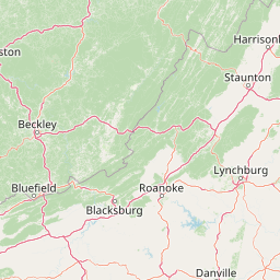
Map view of Rich Hole Wilderness

Use this park location map to pinpoint Rich Hole Wilderness in United States of America, understand its exact geographic position, and read its mapped placement within the surrounding landscape more clearly.

Pigeon | © OpenStreetMap contributors

Location context for Rich Hole Wilderness

Virginia
Recorded earthquake history

View Historical Earthquake Records Associated with Rich Hole Wilderness

Explore the documented seismic history for this Appalachian wilderness area through a structured collection of historical earthquake events. This MoriAtlas catalogue provides event details including magnitude and epicentre distance, offering a clear perspective on recorded activity near the Rich Hole Wilderness landscape.

Rich Hole Wilderness Earthquake History

Catalogued events

2 events

Strongest magnitude

Magnitude 3.5

Most recent event

Apr 22, 1991

This history includes earthquakes recorded inside the park or within 50 km of its borders

Park atlas

Compare nearby national forests and protected areas across western Virginia.

Parks Near Rich Hole Wilderness and Surrounding Protected Landscapes

Explore other protected areas near Rich Hole Wilderness to compare rugged Appalachian ridge and hollow terrain. Continuing your geographic research reveals connected forest ecosystems and regional park diversity across the surrounding mountains.
Wildlife reserveVirginia
3.4 km away#1 closest

Northwest

Rough Mountain Wilderness: Mapping Appalachian Ridges and Protected Terrain

Remote wildlife reserve in western Virginia

Spanning over 9,000 acres, Rough Mountain Wilderness provides a rare example of undisturbed Appalachian forest. The area is characterized by consistently steep slopes, sharp ridgeline topography, and a deep sense of isolation within the George Washington and Jefferson National Forests of western Virginia.

Area
38 km²
Established
1987
IUCN
Ib
Relief
Mountain
A wide watercolor illustration showing rolling mountains in pastel shades of pink, purple, and green, with a line of trees and a reflective body of water in the foreground, framed by bare tree branches on the sides.
Protected areaVirginia
29 km away#2 closest

Southeast

James River Face Wilderness: Mapping the Topography of Virginia's Blue Ridge Protected Landscapes

Geographic overview of mountain wildlands and boulder fields

Spanning over 8,900 acres, James River Face Wilderness serves as a vital protected area within the Appalachian mountain chain. The landscape contains steep creek drainages, vertical ridgelines, and significant geological formations such as the Devils Marbleyard, offering a comprehensive study of central Virginia's complex forest ecosystems and rugged mountain terrain.

Area
36.05 km²
Established
1975
IUCN
Ib
Relief
Mountain
Watercolor painting showing layers of soft green hills and mountain ridges fading into a light hazy background.
Protected landscapeWest Virginia
33 km away#3 closest

North

Monongahela National Forest: Protected Appalachian Landscapes and Regional Geography

Mapping West Virginia wilderness and mountain terrain

Monongahela National Forest protects nearly one million acres of the central Appalachian Mountains. This massive federally managed landscape is defined by the Allegheny Front, the highest peak in the Allegheny range at Spruce Knob, and iconic geological formations like Seneca Rocks. The region represents a vital intersection of climate, hydrology, and biodiversity in the eastern United States, housing eight distinct wilderness areas and complex high-altitude ecosystems.

Area
3,727.8 km²
Established
1920
Visitors
3M annual
Relief
Mountain
Wildlife reserveNelson County
45 km away#4 closest

East

Priest Wilderness: A Deep Dive Into Appalachian Mountain Geography and Protected Forest Boundaries

High elevation ridge terrain in Nelson County, Virginia.

Priest Wilderness stands as a signature protected area in the Blue Ridge Mountains, defined by a dramatic 3,000 foot vertical gain and dense, mature hardwood forests. This documentation maps the rugged ridge and hollow topography that characterizes one of the most significant wilderness sections along the central Appalachian trail corridor.

Area
23.17 km²
Established
2000
IUCN
Ib
Relief
Mountain
A soft watercolor illustration depicting a stream flowing through a forested valley with mountain ridgelines in the background.
Wildlife reserveUnited States of America
About 51 km away#5 closest

Northeast

Ramseys Draft Wilderness: Appalachian Ridge and Valley Protected Landscape and Map Atlas

Examining wilderness boundaries and mountain stream geography in Virginia

Located in western Virginia, Ramseys Draft Wilderness is a federal protected area characterized by its extreme vertical relief and rugged Appalachian topography. Spanning from the main crest of Shenandoah Mountain to the valley floor, this wilderness serves as a vital corridor for high-elevation forest ecosystems, native brook trout, and neotropical migrant birds.

Area
26.38 km²
Established
1984
Relief
Mountain
Climate
Temperate
Watercolor painting of rolling hills, trees, and a river in a scenic landscape
National parkVirginia
66 km away#6 closest

Northeast

Shenandoah National Park: National Park Protected Landscape and Geography

Mapped terrain and protected area context in Virginia.

Shenandoah National Park is a designated national park in Virginia, offering a rich exploration of its protected landscape and geographic features. This page provides detailed atlas-oriented information, focusing on the park's mapped boundaries and its role within the regional geography. Discover the natural terrain and spatial identity of this important US protected area, ideal for understanding park landscapes.

Area
811.176 km²
Established
1935
IUCN
II
Visitors
1.7M annual
Wildlife reserveVirginia
77 km away#7 closest

Southwest

Mountain Lake Wilderness: Protected Appalachian Geography and Mountain Landscapes

High-elevation wetlands and ridge-line geography in Virginia

Mountain Lake Wilderness protects a compact yet biologically diverse landscape where cool, moist conditions support rare mountain bogs and red spruce forests. This protected area along the Eastern Continental Divide features rocky outcrops like White Rocks and War Spur Overlook, providing panoramic views of the surrounding Ridge and Valley terrain within the Jefferson National Forest.

Area
44.66 km²
Established
1984
IUCN
Ib
Relief
Mountain
Watercolor illustration depicting a serene mountain landscape with a winding river, rolling hills, and scattered trees against a light background.
Protected landscapeVirginia
About 84 km away#8 closest

Northeast

George Washington and Jefferson National Forests: Appalachian Protected Landscape Mapping

Explore mountain ridges, river valleys, and wilderness corridors in Virginia.

Covering one of the largest public forest blocks in the eastern United States, George Washington and Jefferson National Forests offer a unique look at the central Appalachian mountain terrain. The area includes extensive wilderness tracts, the Appalachian Trail corridor, and significant geological landmarks like the Breaks gorge. Analyze the protected landscape boundaries and topographic features that define this major regional watershed and forest network.

Area
7,247.65 km²
Established
1995
Relief
Mountain
Climate
Temperate

Common questions about visiting, size, designation, and location context for Rich Hole Wilderness

Rich Hole Wilderness FAQs for park facts, access, geography, and protected area context

Find quick answers about Rich Hole Wilderness, including protected-area facts, park geography, trail and visitor context, and how the park fits into its surrounding country and regional landscape.
MoriAtlas Explorer

Continue Your Protected Areas Search Across the Global Atlas

Deepen your exploration by continuing the structured search for national parks and protected areas worldwide. Utilize the comprehensive filtering capabilities to compare different conservation landscapes and refine your understanding of global park geography. Discover more about the distribution and characteristics of protected natural areas.

Global natural geography