Mori Atlas logo
Wildlife reserveReserva de Vida Silvestre Ríos Blanco y Negro

Mapping the transitional forest landscapes and floodplain river systems of northeastern Bolivia

Reserva de Vida Silvestre Ríos Blanco y Negro: A Protected Lowland Wildlife Reserve Atlas

Reserva de Vida Silvestre Ríos Blanco y Negro spans over one million hectares, forming a vital ecological bridge between the Chiquitano dry forest and the humid Amazon basin. This protected landscape is defined by the seasonal floodwaters of the San Pablo and Blanco rivers, which create extensive várzea forest ecosystems across the Santa Cruz region. The reserve serves as a critical hydrological hub that supports biodiversity and maintains the integrity of downstream wetland systems.

amazon basintropical forestlowland forestchiquitano dry forestvárzea forestfloodplain

Reserva de Vida Silvestre Ríos Blanco y Negro

Wildlife reserve

Park overview

Structured park overview, official facts, and landscape profile for Ríos Blanco y Negro Wildlife Reserve

Ríos Blanco y Negro Wildlife Reserve park facts, protected area profile, and essential visitor context

Review the core facts for Ríos Blanco y Negro Wildlife Reserve, including designation, size, terrain, visitor scale, habitats, and operating context in one park-focused overview.

About Ríos Blanco y Negro Wildlife Reserve

The Ríos Blanco y Negro Wildlife Reserve is one of the largest protected areas in the Bolivian lowlands and a major component of the country's conservation network in the department of Santa Cruz. Stretching across portions of the municipalities of Concepción, Ascensión de Guarayos, and Urubichá, it covers a vast expanse of forested lowland that links two of South America's most ecologically significant biomes: the Chiquitano Dry Forest to the south and the Amazon rainforest to the north.

The reserve's identity is shaped strongly by water. The San Pablo and Blanco rivers transport large quantities of nutrients and sediments, and their seasonal overflows create extensive floodplains that support várzea forests. These mosaic forests are home to valuable tree species such as mara (Swietenia macrophylla) and cusi (Orbignya phalerata), as well as palms like marayaú (Bactris major) and chontilla (Bactris dahgreniana) that are important for both wildlife and local communities. The annual flood pulse also extends well beyond the reserve, helping to regulate the wetlands of Baures and Magdalena in the Beni department.

Beyond its ecological role, the reserve is deeply integrated with the lives of the indigenous peoples who live in and around it. The Guarayo and Chiquitano communities harvest forest products, practice subsistence fishing and hunting, and maintain small-scale agricultural plots, all of which connect the protected area to enduring regional traditions. Although threats from illegal logging, unregulated hunting, and agricultural frontier expansion remain real concerns, ongoing management efforts involving regional government, municipalities, indigenous organizations, and conservation partners such as Fundación Amigos de la Naturaleza aim to safeguard the reserve for the long term.

Quick facts and research context for Ríos Blanco y Negro Wildlife Reserve

The Ríos Blanco y Negro Wildlife Reserve is a departmental protected area in Bolivia's Santa Cruz department, covering roughly 1.4 million hectares across the provinces of Ñuflo de Chávez and Guarayos. It was established on August 10, 1990 through Ministerial Resolution 139/90 and falls under Bolivia's Wildlife Reserve category, which emphasizes the protection, management, and sustainable use of wild species.

The reserve protects a transition zone between the Chiquitano Dry Forest and the Amazon, and its seasonal flooding from the San Pablo and Blanco rivers sustains important várzea forest ecosystems. Its natural hydrology also helps maintain the Baures and Magdalena wetlands further north in the Beni department.

Protection and recognition

Examine documented terrestrial protection metrics and official conservation data parameters

Reserva de Vida Silvestre Ríos Blanco y Negro Protection Status and Mapped Records

Reserva de Vida Silvestre Ríos Blanco y Negro maintains a recorded terrestrial protection scope within the global database. Verified designation parameters outline the established conservation framework without additional international recognition sources.

Protection details

Protection scope
Terrestrial
Transboundary protection
No
WDPA ID
6106232
Park context

Deeper park guide and search-rich context for Ríos Blanco y Negro Wildlife Reserve

Ríos Blanco y Negro Wildlife Reserve history, landscape, wildlife, and travel context

Explore Ríos Blanco y Negro Wildlife Reserve through its history, landscape character, ecosystems, wildlife, conservation priorities, cultural context, and seasonal travel timing in a structured park guide built for atlas discovery and search intent.

Why Ríos Blanco y Negro Wildlife Reserve stands out

Ríos Blanco y Negro is known above all for its role as a vast transitional conservation landscape between the Chiquitano Dry Forest and the Amazon basin. Its seasonal várzea forests, driven by nutrient-rich floodwaters from the San Pablo and Blanco rivers, give the reserve a distinctive ecological character and make it a key area for lowland biodiversity conservation in Bolivia. The reserve is also recognized for its close relationship with the indigenous Guarayo and Chiquitano communities, who depend on its forests, rivers, and floodplains for traditional livelihoods, and for its importance in maintaining the hydrological cycle that sustains the larger Baures and Magdalena wetland systems downstream.

Ríos Blanco y Negro Wildlife Reserve history and protected-area timeline

The Ríos Blanco y Negro Wildlife Reserve was formally established on August 10, 1990 through Ministerial Resolution 139/90. Its creation reflected a recognition that the vast forested lowlands between the Chiquitano Dry Forest and the Amazon basin in northeastern Santa Cruz required legal protection to safeguard their exceptional biodiversity.

From the outset, the reserve was conceived not only as a biodiversity sanctuary but also as a space where sustainable use of natural resources would be allowed. Its official objective was to preserve biological diversity while promoting the ecologically and economically sustainable use of resources. The designation as a Wildlife Reserve placed it within Bolivia's broader framework of protected-area categories designed to balance conservation with the livelihoods of surrounding communities.

In later years, management of the reserve has involved collaboration between the Autonomous Departmental Government of Santa Cruz, the municipalities of Urubichá, Ascensión de Guarayos, and Concepción, the region's indigenous Guarayo and Chiquitano communities, and conservation organizations such as Fundación Amigos de la Naturaleza. These partnerships have produced instruments such as the Plan de Inicio de Gestión, which identifies priority actions to address the pressures facing the reserve.

Ríos Blanco y Negro Wildlife Reserve landscape and geographic character

The landscape of the Ríos Blanco y Negro Wildlife Reserve is dominated by lowland forest terrain typical of northeastern Bolivia, with a relief shaped largely by river systems rather than by major elevation changes. Forested plains stretch across much of its surface, while the courses of the San Pablo and Blanco rivers introduce dynamic hydrological features into an otherwise continuous woodland environment.

The rivers are central to the reserve's geography. Their seasonal flooding alters the surrounding forest, creating expansive várzea, or periodically inundated forests, that shift between aquatic and terrestrial conditions through the year. These floods deposit nutrients and sediments that enrich the soils and support distinctive vegetation along the floodplains.

At a broader scale, the reserve sits within the ecological gradient that links the drier Chiquitano forests to the south with the wetter Amazonian forests further north. This positioning gives the landscape a transitional quality, blending elements of dry-forest and rainforest environments. The reserve's hydrology also feeds into the larger landscape, contributing to the maintenance of the Baures and Magdalena wetlands in the neighboring Beni department.

Ríos Blanco y Negro Wildlife Reserve ecosystems, habitats, and plant life

Ecologically, the Ríos Blanco y Negro Wildlife Reserve occupies a transitional zone between the Chiquitano Dry Forest ecoregion and the Amazon basin, an overlap that gives it a particularly rich mix of flora and fauna. The blending of dry-forest species with Amazonian species creates a mosaic of habitats that supports high levels of biodiversity across multiple groups of organisms.

The reserve's most ecologically distinctive habitats are its várzea, or seasonally flooded forests, generated by the nutrient-rich waters of the San Pablo and Blanco rivers. These forests act as natural regulators of water movement, absorbing rising floodwaters and releasing them gradually, and they support diverse plant communities adapted to alternating wet and dry conditions. Among the notable species found here are palms such as marayaú (Bactris major) and chontilla (Bactris dahgreniana), and timber and multipurpose trees such as mara (Swietenia macrophylla) and cusi (Orbignya phalerata).

Beyond the floodplain forests, the reserve's upland forests complete a mosaic of terrestrial and riparian ecosystems. The interaction between these habitats and the wider Amazonian forest cover makes the reserve an important refuge for species that depend on both intact forest and intact hydrological cycles.

Ríos Blanco y Negro Wildlife Reserve wildlife and species highlights

Because of its transitional position between the Chiquitano Dry Forest and the Amazon, and because of its largely intact forest cover, the Ríos Blanco y Negro Wildlife Reserve supports a broad array of wildlife typical of lowland Bolivia. The mosaic of dry-forest and Amazonian habitats, combined with the seasonal flooding of the San Pablo and Blanco river valleys, creates conditions for diverse mammal, bird, reptile, fish, and amphibian communities.

The reserve's várzea forests are particularly important for species that depend on seasonally flooded environments. Fish populations in the San Pablo and Blanco rivers are sustained by nutrient-rich conditions, and the periodic inundations of the floodplain forests create rich feeding and breeding grounds for a wide range of aquatic and semi-aquatic species. Upland forest areas, meanwhile, support more typical Amazonian and Chiquitano fauna, including game species traditionally hunted by local communities.

Although detailed wildlife inventories are limited, the reserve's ecological importance is widely recognized at the national level, and the loss of its forests or disruption of its flood cycles would have significant consequences for lowland biodiversity in this part of Bolivia.

Ríos Blanco y Negro Wildlife Reserve conservation status and protection priorities

The Ríos Blanco y Negro Wildlife Reserve is recognized as one of the most important conservation areas in the Bolivian lowlands because of its size, its ecological transition between the Chiquitano Dry Forest and the Amazon, and its role in sustaining downstream wetlands. Its 1.4 million hectares protect a continuous block of lowland forest that is increasingly rare in a region facing rapid land-use change.

The reserve's conservation value is closely linked to hydrology. By allowing the San Pablo and Blanco rivers to flood naturally across large forested areas, the reserve helps regulate water flows and nutrient cycles that extend far beyond its borders, maintaining the Baures and Magdalena wetlands in the Beni department. The várzea forests themselves serve as natural buffers, storing water during high-flow periods and gradually releasing it through drier seasons.

Conservation management is a shared effort involving the Autonomous Departmental Government of Santa Cruz, the municipalities of Urubichá, Ascensión de Guarayos, and Concepción, the indigenous Guarayo and Chiquitano communities, and organizations such as Fundación Amigos de la Naturaleza. The development of a Plan de Inicio de Gestión reflects a strategic approach to addressing the principal threats, which include illegal logging, indiscriminate hunting and fishing, and the expansion of agricultural lands into forest areas. Day-to-day conservation work is carried out by park rangers and technical staff committed to preserving this high-biodiversity Amazonian territory.

Ríos Blanco y Negro Wildlife Reserve cultural meaning and human context

The Ríos Blanco y Negro Wildlife Reserve is closely tied to the cultural landscape of northeastern Santa Cruz, where the indigenous Guarayo and Chiquitano peoples have shaped relationships with the forest for generations. The reserve is not only an ecological space but also a home and resource base for communities whose traditions remain closely connected to its rivers, plants, and animals.

Local communities gather forest products such as construction timber, resins, fibers, fruits, and medicinal plants from the reserve, including species like the marayaú and chontilla palms, the cusi palm, and the mara tree. Subsistence fishing in the rivers and seasonal hunting also remain important components of daily life, while small-scale agriculture produces goods sold in nearby local markets.

The reserve's management framework explicitly involves these communities, reflecting the recognition that the long-term conservation of such a vast area cannot be separated from the cultural identity, traditional knowledge, and livelihoods of the people who have historically inhabited it.

Top sights and standout views in Ríos Blanco y Negro Wildlife Reserve

The defining qualities of the Ríos Blanco y Negro Wildlife Reserve are its sheer scale, its transitional ecology, and the central role of water in shaping its forests. As one of Bolivia's largest protected lowland areas, it offers a rare opportunity to experience a continuous landscape where dry-forest and Amazonian environments meet.

Among its most distinctive assets are the nutrient-rich floodplains of the San Pablo and Blanco rivers, which generate extensive várzea forests that function as natural water regulators. The reserve's ecological influence reaches beyond its boundaries through its contribution to the maintenance of the Baures and Magdalena wetlands downstream. Its deep cultural connection with the Guarayo and Chiquitano peoples, and the collaborative management arrangements that include those communities, also mark it as a notable example of integrated conservation in the Bolivian Amazon.

Best time to visit Ríos Blanco y Negro Wildlife Reserve

The character of a visit to the Ríos Blanco y Negro Wildlife Reserve is closely tied to the seasonal rhythm of the San Pablo and Blanco rivers. During the wet season, when the rivers swell with nutrient-rich waters, the reserve's floodplains expand and its várzea forests become fully active ecologically; waterways rise, fish populations move, and wildlife concentrates along the flooded margins. This period offers the most dramatic expression of the reserve's hydrological dynamics and is generally when birdlife, aquatic species, and forest productivity are at their peak.

During drier months, water levels recede, exposing more of the underlying terrain and concentrating wildlife around remaining water bodies. Travel conditions, visibility for forest observation, and accessibility of riverbanks all tend to shift with these seasonal cycles. In both seasons, the reserve's remote and largely undeveloped character means that successful visits depend on careful planning, local guidance, and respect for the indigenous communities whose territories the reserve overlaps with.
Monthly climate preview

Long term climate patterns and recorded monthly weather rhythms across the protected area

Reserva de Vida Silvestre Ríos Blanco y Negro Average Temperature and Monthly Precipitation Normals

Historical climate data from the representative coordinate outlines recorded monthly temperature ranges and precipitation variations across the protected landscape. Examining the complete twelve month profile provides detailed numerical context for long term meteorological trends at this location.
Annual mean26 °C
24 °C29 °C
Jan26°
Feb26°
Mar26°
Apr25°
May24°
Jun24°
Jul25°
Aug27°
Sep28°
Oct29°
Nov27°
Dec26°
Warmest month
October

28.7 °C

Coolest month
June

24.1 °C

Wettest month
February

7.8 mm/day

Driest month
July

0.6 mm/day

Park location guide

Geography guide, regional context, and park location map for Ríos Blanco y Negro Wildlife Reserve

Ríos Blanco y Negro Wildlife Reserve park geography, regions, and map view in Bolivia

Understand where Ríos Blanco y Negro Wildlife Reserve sits in Bolivia through a broader geographic reading of the surrounding landscape, nearby location context, and its mapped position within the national park landscape.

How Ríos Blanco y Negro Wildlife Reserve fits into Bolivia

Bolivia, officially the Plurinational State of Bolivia, is a landlocked country in central South America. It features diverse geography including the Andean mountain range, Amazonian plains, Gran Chaco, and the Pantanal wetland. The country has a population of approximately 11.4 million and is administratively divided into nine departments, with La Paz as the seat of government and Sucre as the constitutional capital.

Wider geography shaping Ríos Blanco y Negro Wildlife Reserve in Bolivia

Bolivia is located in central South America, bordered by Brazil to the north and east, Paraguay to the southeast, Argentina to the south, Chile to the southwest, and Peru to the west. The country is divided between a western Andean region and tropical lowlands to the east and north. It includes the Amazonian plain, Gran Chaco, temperate valleys, the high-altitude Altiplano plateau, and part of the Pantanal wetland along its eastern border.

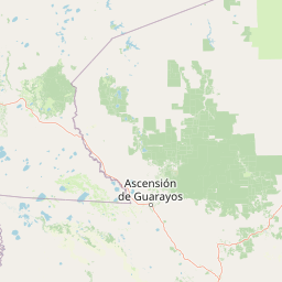
Map view of Ríos Blanco y Negro Wildlife Reserve

Use this park location map to pinpoint Ríos Blanco y Negro Wildlife Reserve in Bolivia, understand its exact geographic position, and read its mapped placement within the surrounding landscape more clearly.

Pigeon | © OpenStreetMap contributors

Location context for Ríos Blanco y Negro Wildlife Reserve

Santa Cruz
Park atlas

Compare regional park geography and adjacent lowland conservation landscapes

Explore Protected Areas Near Reserva de Vida Silvestre Ríos Blanco y Negro

Browse nearby national parks and protected areas located around Reserva de Vida Silvestre Ríos Blanco y Negro to examine regional ecological gradients. Evaluating adjacent lowland forest reserves and river basin landscapes provides broader context for tropical conservation systems.
Protected areaSanta Cruz Department
About 93 km away#1 closest

East

Área protegida municipal Bajo Paraguá: Geographic and Protected Area Overview

Lowland forest landscapes in Santa Cruz Department, Bolivia.

Deepen your knowledge of the Área protegida municipal Bajo Paraguá, a significant protected landscape that anchors conservation efforts in the Chiquitano dry forest. This area borders the Noel Kempff Mercado National Park and serves as a vital transition zone for lowland ecosystems and indigenous territorial defense.

Area
9,830.06 km²
Established
2021
Visitors
16K annual
Relief
Upland
Watercolor painting of a tranquil landscape featuring a calm water body in the foreground, lines of trees, and soft hills in the background under a pale sky.
Nature reserveBeni
About 98 km away#2 closest

Northwest

Reserva científica, ecológica y arqueológica Kenneth Lee: Beni Nature Reserve Atlas

Amazonian forest and wetland archaeological landscape

This protected area in the Beni department of Bolivia encompasses a sophisticated interplay of tropical forests and expansive seasonally inundated grasslands. Known for its wild cacao populations and traces of hydraulic cultures, the reserve serves as a critical reference for integrated natural and cultural conservation within the Amazonian basin.

Area
4,393 km²
Established
1996
Relief
Lowland
Climate
Tropical
National parkSanta Cruz Department
About 129 km away#3 closest

East

Noel Kempff Mercado National Park: Detailed Protected Landscape Map and Geography

Explore national park boundaries and regional landscape context in Santa Cruz.

Noel Kempff Mercado National Park is a crucial protected area offering deep insights into Bolivia's natural geography. This entry provides specific details on its mapped landscape and geographic position within the Santa Cruz Department, enabling users to explore its protected boundaries and understand its regional context for atlas-based discovery. Dive into the mapped terrain and natural features that define this significant national park.

Area
15,523 km²
Established
1979
IUCN
II
Relief
Mixed relief
Protected landscapeSanta Cruz
About 226 km away#4 closest

Southwest

Área Natural de Manejo Integrado Humedales del Norte Protected Landscape and Wetland Atlas

Mapping the floodplain ecosystems of northern Santa Cruz, Bolivia.

An extensive protected area in northern Santa Cruz that sustains vital Amazonian river systems and seasonal wetland mosaics. This landscape supports complex hydrological functions, including the regulation of climate and regional water cycles, through its vast network of periodically flooded forest tracts and permanent waterways.

Area
4,900.51 km²
Established
2012
Relief
Lowland
Scope
Terrestrial
Protected landscapeBeni
About 248 km away#5 closest

West

Parque Municipal y Área Natural de Manejo Integrado Gran Mojos: Regional Geography

Protected floodplain ecosystems in the Beni department of Bolivia.

Analyze the spatial distribution of this large protected area located in the Mamoré River basin. Learn about its dual-designation structure, bridging core municipal forests with integrated management zones that preserve vital lowland Amazonian habitats and endemic biodiversity within the Llanos de Moxos ecoregion.

Area
5,804.3 km²
Established
2017
Relief
Lowland
Scope
Terrestrial
A watercolor painting showing a soft, atmospheric landscape with a winding river, green banks, trees, and distant low hills against a white background.
Protected areaBeni Department
About 260 km away#6 closest

West

Área Protegida Municipal Ibare-Mamoré: Geography and Protected Area Context

Riverine landscapes and wetlands in Bolivia's Beni Department

The Área Protegida Municipal Ibare-Mamoré encompasses a diverse range of ecosystems, from upland forests to open grasslands and shifting river channels. As a key conservation unit near the city of Trinidad, this area highlights the ecological importance of the Llanos de Moxos region through its interconnected aquatic and terrestrial habitats.

Area
256.08 km²
Established
2011
Relief
Lowland
Climate
Tropical
National parkCochabamba Department
About 334 km away#7 closest

Southwest

Carrasco National Park: National Park Status and Protected Landscape Geography

Explore mapped boundaries within Cochabamba Department.

Carrasco National Park, situated within the Cochabamba Department, represents a critical national park entity. This focus provides users with an atlas-centric view of its protected landscape, detailing its geographic significance and mapped features. Understand the park's terrain and regional context, offering a clear perspective on its conservation value and mapped presence.

Area
6,226 km²
Established
1991
IUCN
II
Relief
Mountain
A soft watercolor painting showing a winding river through a valley with trees and palms on the banks and rolling hills in the background.
Nature reserveSanta Cruz
About 338 km away#8 closest

South

Parque de Protección Ecológica del Río Piraí: Protected Geography and Riverine Landscapes

Nature reserve and flood-control corridor in Santa Cruz, Bolivia

This nature reserve encompasses a narrow, sediment-rich corridor following the Río Piraí. It protects representative lowland habitats including Chiquitano dry forest and gallery woodlands, while balancing vital flood-mitigation roles against the pressures of urban expansion. Explore the map of this unique alluvial landscape to understand its ecological significance and role in the regional geography of Santa Cruz.

Area
15.868 km²
Established
1991
Relief
Lowland
Climate
Tropical

Common questions about visiting, size, designation, and location context for Ríos Blanco y Negro Wildlife Reserve

Ríos Blanco y Negro Wildlife Reserve FAQs for park facts, access, geography, and protected area context

Find quick answers about Ríos Blanco y Negro Wildlife Reserve, including protected-area facts, park geography, trail and visitor context, and how the park fits into its surrounding country and regional landscape.
MoriAtlas Explorer

Continue Your Protected Areas Search Across the Global Atlas

Deepen your exploration by continuing the structured search for national parks and protected areas worldwide. Utilize the comprehensive filtering capabilities to compare different conservation landscapes and refine your understanding of global park geography. Discover more about the distribution and characteristics of protected natural areas.

Global natural geography