Why Área Natural de Manejo Integrado Humedales del Norte stands out
The reserve is best known for protecting an extensive tract of Amazonian floodplain wetlands in northern Santa Cruz, including river systems that host the Amazon river dolphin, locally known as the bufeo. Its vast seasonally flooded forests and slow-moving rivers are central to the regional hydrological cycle and to climate regulation across the surrounding lowlands.
Área Natural de Manejo Integrado Humedales del Norte history and protected-area timeline
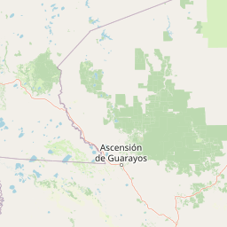
The reserve has a relatively short formal history, having been created in 2012 through Santa Cruz Departmental Law 98. The legislation established the Área Natural de Manejo Integrado Humedales del Norte as a departmental protected area, with an initial extent of approximately 490,051 hectares crossing the provinces of Ichilo, Guarayos, and Obispo Santistevan.
Its creation reflected growing awareness of the ecological importance of the floodplain wetlands in northern Santa Cruz and a departmental effort to safeguard hydrological and climatic functions that support both ecosystems and human communities in the lowlands.
From 2017 onward, the Gobierno Autónomo Departamental de Santa Cruz began pursuing international recognition of the reserve as a Ramsar Site. Although the formal inscription process is complex and involves coordination with the national government, the initiative signals a shift toward treating the area as a wetland of hemispheric, not just departmental, importance.
Área Natural de Manejo Integrado Humedales del Norte landscape and geographic character
The landscape of Humedales del Norte is defined by the dynamics of Amazonian floodplains. The terrain is largely flat to gently undulating, shaped by the rise and fall of rivers that inundate vast stretches of forest during the wet season. Slow-moving waterways, permanent and seasonal lagoons, and associated flood-tolerant forests form the structural backbone of the area.
Seasonal water level changes are one of the defining features of the landscape. During high-water periods, large forest tracts are submerged, creating complex aquatic and semi-aquatic environments. In drier months, the same terrain re-emerges as a mosaic of saturated soils, isolated pools, and channels that retain water for months. This alternation produces a shifting landscape that is neither purely terrestrial nor purely aquatic but a continually responsive floodplain system.
Surrounding the wetland core are forested transitions that gradually connect to drier terra firme forest and to agricultural landscapes that border the protected area. This gradient between flooded interior forest, river-edge vegetation, and upland forest underscores the importance of protecting the reserve at the scale necessary to maintain the natural hydrological pulse.
Área Natural de Manejo Integrado Humedales del Norte ecosystems, habitats, and plant life
Ecologically, the reserve belongs to the Amazonian floodplain ecoregion, a system characterized by high biological productivity driven by nutrient-rich waters and seasonal dynamics. Its habitats include permanently flooded forests, seasonally inundated forests, river channels, oxbow lakes, and emergent wetland vegetation, all interlinked within the larger Amazonian drainage.
The combination of permanent water and seasonal fluctuation creates a rich suite of microhabitats. Shaded forest streams, open-water lagoons, flooded grasslands, and saturated palm swamps each support distinct ecological communities. The reserve's continuity across such a large area is significant for ecological processes that depend on landscape-scale habitat connectivity, including fish movements, waterbird dispersal, and the breeding cycles of many floodplain species.
The wetland mosaic is also important for nutrient cycling. Leaf litter, sediment, and organic material carried by floodwaters contribute to the productivity of aquatic and riparian food webs, while forest cover stabilizes banks, filters water, and maintains the dark, tannin-rich conditions of forest streams. These processes together sustain a functioning Amazonian wetland system within the broader Bolivian Amazon.
Área Natural de Manejo Integrado Humedales del Norte wildlife and species highlights
The reserve's most emblematic wildlife presence is the Amazon river dolphin, locally known as the bufeo, which inhabits the rivers of the area. Its continued presence is widely regarded as an indicator of healthy river systems and is a point of regional pride and ecological interest.
The flooded forests, rivers, and lagoons also support a wide range of aquatic and semi-aquatic species typical of southwestern Amazonia, including various fish groups that migrate or reproduce in response to the flood pulse. The mosaic of habitats makes the area conducive to waterbirds and to forest species that tolerate seasonal flooding, both of which benefit from the connectivity that the reserve maintains.
Because the area is large and largely continuous with surrounding forested landscapes, it offers refuge for wildlife sensitive to human disturbance. The presence of long river corridors, intact flooded forest, and a relatively intact seasonal hydrology provides conditions that allow a more complete expression of Amazonian fauna than would be possible in fragmented or degraded landscapes.
Área Natural de Manejo Integrado Humedales del Norte conservation status and protection priorities
Conservation in Humedales del Norte emphasizes the protection of large-scale ecological and hydrological processes rather than single-species preservation. The 2012 creation of the area as an Área Natural de Manejo Integrado reflects this integrated approach, recognizing wetlands as systems that simultaneously provide habitat, regulate climate, and sustain water resources.
The reserve is positioned as a candidate Ramsar Site, an international designation managed under the Convention on Wetlands. Inscription would place it within a global framework for wetland conservation and bring additional standards of monitoring and management. Bolivia currently leads the world in cumulative Ramsar-designated area, and the addition of Humedales del Norte would further consolidate this status.
Like other forested protected areas in Bolivia, the reserve faces pressures from illegal settlement and indiscriminate logging, which are ongoing concerns for conservation management. Effective protection depends on maintaining the integrity of the floodplain dynamics and the surrounding forest, both of which are vulnerable to fragmentation and to changes in land use along the borders of the protected area.
Top sights and standout views in Área Natural de Manejo Integrado Humedales del Norte
Humedales del Norte is distinguished by the sheer scale of its floodplain wetlands, which collectively regulate climate, temperature, wind patterns, and the hydrological cycle across a major portion of northern Santa Cruz. Its 2012 founding marked a deliberate effort to protect these regulating functions at a meaningful landscape scale.
The presence of the bufeo, the Amazon river dolphin, lends the reserve a powerful wildlife symbol rooted in the regional Amazonian identity. Coupled with the ongoing pursuit of Ramsar recognition, the reserve stands out as a natural area where ecological function, hydrological importance, and conservation ambition converge.
Best time to visit Área Natural de Manejo Integrado Humedales del Norte
The experience of the area varies strongly with the seasonal flood cycle of the Amazonian lowlands. During high-water months, large parts of the forest flood, river channels expand, and traveling through the interior requires boats; wildlife tends to concentrate along waterways and in tree canopies. During lower-water months, access along rivers is easier in some reaches, exposed beaches and bars appear, and forest wildlife becomes more accessible along trails that cut through drier terrain.
For water-associated wildlife, including river dolphins and waterbirds, periods of transition between flood and low water can be particularly dynamic. Those interested in flooded forest landscapes generally favor the high-water season for the full expression of the wetland mosaic, while those focused on terra firme transitions and drier forest species may prefer months when the floodplain recedes.