Mori Atlas logo
National parkIsiboro Sécure National Park and Indigenous Territory

Discover the mapped boundaries and regional natural context of this Bolivian national park.

Isiboro Sécure National Park and Indigenous Territory: Protected Landscape and Geographic Atlas

(Territorio Indígena y Parque Nacional Isiboro Sécure)

Isiboro Sécure National Park and Indigenous Territory represents a significant protected national park entity within Bolivia. This atlas-focused page provides a detailed view of its geographic scope, helping users understand its placement within the country's diverse natural landscapes and its role as a protected area. Explore the mapped terrain and regional context that define this important Bolivian protected territory.

Amazon rainforestIndigenous territoryYungas ecoregionBiodiversity hotspotWetlandsNational park

Isiboro Sécure National Park and Indigenous Territory

National park

Park overview

Structured park overview, official facts, and landscape profile for Isiboro Sécure National Park and Indigenous Territory

Isiboro Sécure National Park and Indigenous Territory park facts, protected area profile, and essential visitor context
Review the core facts for Isiboro Sécure National Park and Indigenous Territory, including designation, size, terrain, visitor scale, habitats, and operating context in one park-focused overview.

About Isiboro Sécure National Park and Indigenous Territory

Isiboro Sécure National Park and Indigenous Territory represents a distinctive model of protected area management that integrates conservation objectives with the ancestral rights of indigenous communities. Located in northern Bolivia, the park encompasses a vast territory spanning the transition zone between the Andean foothills and the Amazon lowlands, creating a complex mosaic of ecosystems that support extraordinary biodiversity. The park's creation in 1965 reflected Bolivia's early efforts to establish a national park system, while its 1990 recognition as indigenous territory marked a significant milestone in the country's approach to indigenous land rights. Today, TIPNIS stands at the center of important conservation and development debates, facing pressures from agricultural colonization, infrastructure projects, and oil exploration that test the boundaries of protected area management and indigenous rights protections.

Quick facts and research context for Isiboro Sécure National Park and Indigenous Territory

TIPNIS covers approximately 1.37 million hectares in northern Bolivia, making it one of the country's largest protected areas. The park sits at the geographic intersection of the Cochabamba and Beni departments, spanning the transition between highland and lowland ecosystems. Four distinct ecosystems are protected within its boundaries: the flooded savannas of the Moxos plain, sub-Andean Amazonian forest, pre-Andean Amazonian forest, and the Bolivian-Peruvian Yungas. The park's rivers—the Isiboro, Sécure, and Ichoa—form part of the Mamoré River drainage system, which feeds into the broader Amazon Basin. The park was established by Supreme Decree 7401 in 1965 and gained indigenous territory status through Supreme Decree 22610 in 1990 following sustained advocacy by local communities.

Park context

Deeper park guide and search-rich context for Isiboro Sécure National Park and Indigenous Territory

Isiboro Sécure National Park and Indigenous Territory history, landscape, wildlife, and travel context
Explore Isiboro Sécure National Park and Indigenous Territory through its history, landscape character, ecosystems, wildlife, conservation priorities, cultural context, and seasonal travel timing in a structured park guide built for atlas discovery and search intent.

Why Isiboro Sécure National Park and Indigenous Territory stands out

TIPNIS is best known for its dual status as both a national park and indigenous territory, a rare designation that reflects Bolivia's commitment to recognizing indigenous land rights within conservation frameworks. The park protects critical habitat within the Bolivian Yungas, one of the world's most biodiverse regions and a recognized biodiversity hotspot. Its location at the ecological crossroads between the Andes and Amazon creates exceptional habitat diversity, supporting more than 1,500 documented species across major vertebrate groups. The park is also notable for the ongoing social and environmental conflicts surrounding development pressures, particularly the proposed Villa Tunari, San Ignacio de Moxos Highway that would bisect the territory, making TIPNIS a focal point for indigenous rights movements and environmental conservation debates in Bolivia.

Isiboro Sécure National Park and Indigenous Territory history and protected-area timeline

The establishment of TIPNIS as a national park occurred on November 22, 1965, through Supreme Decree 7401, making it one of Bolivia's earliest formally designated protected areas. For decades, the park existed primarily as a conservation space without formal recognition of the indigenous communities who had ancestrally inhabited the territory. The situation changed dramatically in the late 1980s and early 1990s as indigenous communities organized to assert their land rights. The Subcentral Indígena del TIPNIS was established in July 1988 to coordinate indigenous advocacy, and the Confederation of Indigenous Peoples of the Bolivian East organized the March for Territory and Dignity, applying sustained pressure on the government. These efforts culminated in Supreme Decree 22610 on September 24, 1990, which formally recognized the territory as Native Community Land. In 2009, following land clearance by the National Agrarian Reform Institute, operative collective title to approximately 1.09 million hectares was awarded to the Subcentral TIPNIS, though significant portions of the park remain contested between indigenous communities, agrarian colonists, and ranchers.

Isiboro Sécure National Park and Indigenous Territory landscape and geographic character

The physical landscape of TIPNIS encompasses remarkable topographic and ecological diversity, shaped by its position at the meeting point of several distinct geographical zones. The park includes vast flooded savannas of the Moxos plain, characterized by varied relief and seasonal inundation patterns that create a dynamic wetland environment similar to the llanos of Colombia and the Pantanal of southeastern Bolivia. Rolling terrain gives way to dense Amazonian forests as the landscape descends toward the lowland basin, while the park's eastern portions include portions of the Yungas, the humid forest zone that descends from the Andean highlands into the Amazon. Three major rivers—the Isiboro, Sécure, and Ichoa—drain the territory, flowing northward to join the Mamoré River system and ultimately the Amazon Basin. The Sécure River and the Isiboro River form the northern and southern boundaries respectively, while the Ichoa River flows through the central portion of the park. Laguna Bolivia, a major interior lake, provides an important wildlife observation site accessible by water or overland trails.

Isiboro Sécure National Park and Indigenous Territory ecosystems, habitats, and plant life

The ecological character of TIPNIS is defined by the remarkable diversity of habitats contained within its boundaries, reflecting the park's position at a critical biogeographic crossroads. Four major ecosystems characterize the territory: the seasonally flooded savannas of the Moxos plain, sub-Andean Amazonian forest, pre-Andean Amazonian forest, and the Bolivian-Peruvian Yungas. This mosaic of habitats creates exceptional biodiversity, with the Yungas portion representing one of the most species-rich biomes in the world. The river systems—the Isiboro, Sécure, and Ichoa—serve as critical aquatic corridors linking the different habitat types and providing essential resources for both wildlife and human communities. The drainage patterns correspond to two distinct bioregions: the Yungas Mountainous Humid Forest and the Madeira Humid Forest, each supporting characteristic species assemblages adapted to their specific environmental conditions.

Isiboro Sécure National Park and Indigenous Territory wildlife and species highlights

TIPNIS supports extraordinary wildlife diversity, with the park serving as a refuge for more than 1,500 documented vertebrate species across major taxonomic groups. The mammal population includes 218 documented species, representing a significant portion of Bolivia's mammalian diversity. Avian diversity is particularly remarkable, with 992 bird species recorded within the park's boundaries—a testament to the importance of the Yungas and Amazonian habitats as major bird migration routes and breeding areas. The amphibian fauna includes 157 species, while reptile diversity encompasses 131 documented species. The park's river systems support notable aquatic species, including populations of pink river dolphins that inhabit the Sécure and Isiboro rivers. The flooded savannas provide critical habitat for wetland-dependent species, while the forest interiors support diverse communities of primates, carnivores, and other forest-dwelling mammals.

Isiboro Sécure National Park and Indigenous Territory conservation status and protection priorities

TIPNIS faces significant conservation challenges that test the effectiveness of Bolivia's protected area management and indigenous land rights frameworks. The park has experienced substantial deforestation, particularly in the southern portion known as Polygon 7, where agricultural colonization by coca farmers has progressed since the 1970s. Government estimates suggest approximately 10% of the park has been cleared, with projections indicating that continuing colonization could remove up to 43% of forest cover by 2030. The proposed Villa Tunari–San Ignacio de Moxos Highway, which would bisect the park, has generated intense controversy and mobilization from indigenous communities and environmental advocates. Oil and gas exploration concessions also pose threats, with several blocks authorized within the park boundaries. While Law 180 of 2011 initially declared TIPNIS an intangible zone prohibiting highway construction, subsequent legislation in 2017 opened the door for infrastructure development and private investment, creating ongoing uncertainty about the park's protected status.

Isiboro Sécure National Park and Indigenous Territory cultural meaning and human context

The human dimension of TIPNIS is defined by the presence of three indigenous peoples who have ancestrally inhabited these lands and maintain their cultural traditions within the park's boundaries. The Tsimané (also known as Chimane), Yuracaré, and Mojeño-Trinitario peoples together numbered approximately 12,400 inhabitants at the 2001 census, distributed across 64 communities. These communities have maintained their traditional land use practices and cultural identities despite increasing pressures from external development interests. The indigenous population organized through the Subcentral Indígena del TIPNIS has played a central role in defending the territory against external threats, notably through the historic March for Territory and Dignity and subsequent mobilizations against the proposed highway. The southern portion of the park has been colonized since the 1970s by agricultural settlers, primarily coca farmers organized through the Federation of the Tropic of Cochabamba, creating complex social dynamics between indigenous communities and newcomer populations.

Top sights and standout views in Isiboro Sécure National Park and Indigenous Territory

TIPNIS stands as one of Bolivia's largest and most ecologically significant protected areas, encompassing a remarkable transition zone where Andean ecosystems give way to Amazonian forests. The park's dual designation as national park and indigenous territory represents a pioneering approach to conservation that recognizes both biodiversity protection and indigenous land rights. Its four distinct ecosystems—flooded savannas, sub-Andean and pre-Andean Amazonian forests, and the Yungas—support extraordinary biodiversity including nearly 1,000 bird species and 218 mammal species. The park's rivers and Laguna Bolivia provide exceptional wildlife observation opportunities, while the cultural presence of three indigenous peoples maintains living traditions within the territory. The ongoing social and environmental debates surrounding development pressures have made TIPNIS a symbol of indigenous rights and conservation challenges in Bolivia.

Best time to visit Isiboro Sécure National Park and Indigenous Territory

The optimal time to visit TIPNIS depends on the specific experiences sought, as the park's seasonal patterns affect both accessibility and wildlife viewing opportunities. The dry season from May to October generally offers easier navigation of rivers and more comfortable conditions for overland exploration, though water levels may affect access to interior areas like Laguna Bolivia. The wet season from November to April brings higher water levels that allow navigation of flooded areas and may improve access to certain wildlife observation sites. The shoulder months of April and May can offer a balance between favorable conditions and fewer visitors. For wildlife viewing, the drier months often concentrate animals around remaining water sources, while bird activity remains high throughout the year in this biodiverse region.

Park location guide

Geography guide, regional context, and park location map for Isiboro Sécure National Park and Indigenous Territory

Isiboro Sécure National Park and Indigenous Territory park geography, regions, and map view in Bolivia
Understand where Isiboro Sécure National Park and Indigenous Territory sits in Bolivia through a broader geographic reading of the surrounding landscape, nearby location context, and its mapped position within the national park landscape.

How Isiboro Sécure National Park and Indigenous Territory fits into Bolivia

Bolivia, officially the Plurinational State of Bolivia, is a landlocked country in central South America. It features diverse geography including the Andean mountain range, Amazonian plains, Gran Chaco, and the Pantanal wetland. The country has a population of approximately 11.4 million and is administratively divided into nine departments, with La Paz as the seat of government and Sucre as the constitutional capital.

Wider geography shaping Isiboro Sécure National Park and Indigenous Territory in Bolivia

Bolivia is located in central South America, bordered by Brazil to the north and east, Paraguay to the southeast, Argentina to the south, Chile to the southwest, and Peru to the west. The country is divided between a western Andean region and tropical lowlands to the east and north. It includes the Amazonian plain, Gran Chaco, temperate valleys, the high-altitude Altiplano plateau, and part of the Pantanal wetland along its eastern border.

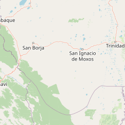
Map view of Isiboro Sécure National Park and Indigenous Territory

Use this park location map to pinpoint Isiboro Sécure National Park and Indigenous Territory in Bolivia, understand its exact geographic position, and read its mapped placement within the surrounding landscape more clearly.

Pigeon | © OpenStreetMap contributors

Location context for Isiboro Sécure National Park and Indigenous Territory

Beni DepartmentCochabamba Department
Park atlas

Trace regional protected-area geography, comparing diverse landscapes across Bolivia's Yungas and Amazon lowlands.

Explore Related Protected Areas Near Isiboro Sécure National Park and Indigenous Territory, Bolivia
Browse a curated list of national parks and protected areas situated near Isiboro Sécure National Park and Indigenous Territory. Discover diverse conservation landscapes across Bolivia, from Andean foothills to Amazonian lowlands and flooded savannas.
Watercolor illustration showing a mountain range with green fields, a river, and soft pastel colors
National parkCochabamba Department

Tunari National Park: Protected Landscape Atlas and Geographic Context

Mapped boundaries within Cochabamba Department's geography.

Tunari National Park represents a vital protected landscape within the Cochabamba Department of Bolivia. This page offers an atlas-centric exploration of the park's geographic boundaries, its relationship to the surrounding regional terrain, and its significance as a national park. Delve into the mapped context of Tunari National Park to understand its protected area status and its contribution to Bolivia's diverse geography.

Area
3,090 km²
Established
1992
IUCN
II
Relief
Mountain
National parkCochabamba Department

Carrasco National Park: National Park Status and Protected Landscape Geography

Explore mapped boundaries within Cochabamba Department.

Carrasco National Park, situated within the Cochabamba Department, represents a critical national park entity. This focus provides users with an atlas-centric view of its protected landscape, detailing its geographic significance and mapped features. Understand the park's terrain and regional context, offering a clear perspective on its conservation value and mapped presence.

Area
6,226 km²
Established
1991
IUCN
II
Relief
Mountain
National parkLa Paz Department

Cotapata National Park and Integrated Management Natural Area: A Protected Landscape in La Paz Department, Bolivia

Explore its mapped boundaries and regional geographic context.

Delve into the protected landscape identity of Cotapata National Park and Integrated Management Natural Area, situated within the La Paz Department of Bolivia. This entry provides essential geographic context, focusing on its mapped protected area status and its contribution to the regional landscape, ideal for atlas-based exploration and understanding Bolivia's conservation network.

Area
600 km²
Established
1993
IUCN
II
Scope
Terrestrial
National parkPotosí Department

Torotoro National Park: Paleontology and Karst Landscape Exploration in Bolivia

Discover prehistoric footprints within dramatic Andean canyon geography.

Torotoro National Park in the Potosí Department is a protected area distinguished by its rich paleontological significance and unique semi-arid mountain terrain. Featuring dramatic canyon systems plunging hundreds of meters deep, the park showcases thousands of Cretaceous dinosaur footprints alongside its complex karst topography, complete with caves and sinkholes, offering a profound glimpse into both ancient life and sculpted natural geography.

Area
165 km²
Established
1989
IUCN
II
Relief
Mountain
National parkSanta Cruz Department

Amboró National Park: Its Protected Area Identity and Geographic Context

Mapped boundaries and regional landscape details.

Amboró National Park is a designated national park situated within the Santa Cruz Department, Bolivia. This entry provides detailed insights into its protected landscape, focusing on its geographical significance and mapped boundaries. Users can explore how Amboró National Park fits into the broader regional geography, enhancing their understanding of conservation areas and mapped natural terrains for atlas-based research and discovery. Its specific location and protected status are crucial for understanding its ecological and geographic role.

Area
4,425 km²
Established
1984
IUCN
II
Relief
Mountain
National parkLa Paz Department

Madidi National Park: National Park Protected Landscape and Geographic Atlas Entry

Explore mapped boundaries and regional context in La Paz Department.

Madidi National Park is a designated national park situated in Bolivia's La Paz Department. This detail entry offers a focused perspective on its protected landscape, its specific geographic setting, and its role within the larger atlas of natural areas. Understand the park's mapped boundaries and its contribution to the regional geography, providing a foundation for structured discovery of Bolivia's protected lands.

Area
18,957.5 km²
Established
1995
IUCN
II
Relief
Mixed relief
National parkBolivia

Sajama National Park National Park: Bolivia's Mapped Protected Landscape for Geographic Exploration

Discover regional geography and mapped protected area context.

Sajama National Park represents a crucial protected area within the geography of Bolivia. This MoriAtlas entry focuses on its identity as a national park, detailing its mapped boundaries and its contribution to the regional atlas of protected lands. Understand the park's landscape context and its significance for geographic discovery within South America's diverse terrains.

Area
1,002 km²
Established
1939
IUCN
II
Relief
Mountain
National parkArica-Parinacota Region

Lauca National Park: Mapped Volcanic Terrain and High-Altitude Protected Landscapes

Explore the geography of this Arica-Parinacota Region national park.

Lauca National Park is a significant protected area in Chile's Arica-Parinacota Region, offering a unique glimpse into the dramatic geography of the high Andes. Its landscape is characterized by imposing volcanic formations, including Parinacota Volcano, and expansive altiplano terrain. This national park serves as a vital protected landscape, inviting detailed exploration of its mapped boundaries, diverse ecosystems, and remarkable natural features for those interested in geographic context and conservation.

Area
1,379 km²
Established
1970
IUCN
II
Visitors
12.1K annual

Common questions about visiting, size, designation, and location context for Isiboro Sécure National Park and Indigenous Territory

Isiboro Sécure National Park and Indigenous Territory FAQs for park facts, access, geography, and protected area context
Find quick answers about Isiboro Sécure National Park and Indigenous Territory, including protected-area facts, park geography, trail and visitor context, and how the park fits into its surrounding country and regional landscape.
MoriAtlas Explorer

Continue Your Protected Areas Search Across the Global Atlas

Deepen your exploration by continuing the structured search for national parks and protected areas worldwide. Utilize the comprehensive filtering capabilities to compare different conservation landscapes and refine your understanding of global park geography. Discover more about the distribution and characteristics of protected natural areas.

Global natural geography