Mori Atlas logo
National parkMadidi National Park

Discover the mapped boundaries and regional atlas context of this significant protected natural area.

Madidi National Park National Park: Protected Landscape and Geographic Context in La Paz Department

(Madidi National Park and Integrated Management Natural Area)

Madidi National Park represents a key protected landscape within Bolivia's La Paz Department. This page serves as the definitive entry point for understanding its protected-area identity, its mapped geographic boundaries, and its place within the broader regional natural terrain. Explore how this national park contributes to the atlas of conservation landscapes, offering structured discovery of its unique environmental context.

Amazon rainforestAndean cloud forestsBiodiversity hotspotIndigenous communitiesTropical wildlifeBirdwatching

Madidi National Park

National park

Park overview

Structured park overview, official facts, and landscape profile for Madidi National Park

Madidi National Park park facts, protected area profile, and essential visitor context
Review the core facts for Madidi National Park, including designation, size, terrain, visitor scale, habitats, and operating context in one park-focused overview.

About Madidi National Park

Madidi National Park represents one of the most significant conservation achievements in South America, protecting an extraordinary spectrum of ecosystems within a single protected boundary. The park straddles the dramatic ecological gradient where the Andean highlands descend into the Amazon basin, creating a mosaic of habitats that supports unparalleled biodiversity. From the cloud forests of the Yungas region where moisture-laden clouds drift through misty treetops, to the steamy lowland rainforests of the Tuichi River valley, Madidi encapsulates ecological zones that would typically require traveling thousands of kilometers to experience. The protected area was established in 1995 and subsequently expanded to include Integrated Management Natural Area status, reflecting Bolivia's commitment to preserving this irreplaceable natural heritage. The park's significance extends beyond its biological wealth to encompass remarkable cultural diversity, as indigenous communities including the Tacana, Ese Ejja, Tsimané, and Mosetén have inhabited these lands for generations, with the Toromona maintaining voluntary isolation from broader society.

Quick facts and research context for Madidi National Park

Madidi National Park occupies 18,957.5 square kilometers in the northwest La Paz Department of Bolivia, spanning three provinces: Franz Tamayo, Iturralde, and Abel Bautista Saavedra. The park encompasses both a national park zone and an Integrated Management Natural Area, with elevations ranging from 180 to 5,760 meters above sea level. The climate varies dramatically by altitude, from cold alpine conditions in the high Andes to tropical heat in the northern lowlands, with an average annual temperature of 26°C and precipitation averaging 716mm yearly. The wet season runs from October to March, while the dry season occurs from May to September. The park is accessible from Rurrenabaque via ferry across the Beni River to San Buenaventura.

Park context

Deeper park guide and search-rich context for Madidi National Park

Madidi National Park history, landscape, wildlife, and travel context
Explore Madidi National Park through its history, landscape character, ecosystems, wildlife, conservation priorities, cultural context, and seasonal travel timing in a structured park guide built for atlas discovery and search intent.

Why Madidi National Park stands out

Madidi is globally recognized as the most biodiverse national park on Earth, hosting over 8,000 vascular plant species, more than 1,254 bird species representing 14 percent of all known bird species, and extraordinary concentrations of mammals, amphibians, reptiles, and aquatic life. The park is the only known home of the Madidi titi monkey, a species discovered by biologist Robert Wallace and named after the GoldenPalace.com casino that funded its discovery through a $650,000 auction. The park spans the ecological transition between the Andes Mountains and Amazon Basin, protecting both the Bolivian Yungas cloud forests and Amazonian lowland rainforest in a single protected landscape.

Madidi National Park history and protected-area timeline

Madidi National Park was established on September 21, 1995, representing the culmination of growing recognition among Bolivian conservationists and international organizations that this region required formal protection. The park's creation came during a period of increased environmental awareness in Bolivia and represented a shift toward establishing large, ecologically connected protected areas that could sustain long-term biodiversity conservation. The original national park designation covered approximately 12,715 square kilometers, with an additional 6,242.5 square kilometers designated as Integrated Management Natural Area to accommodate sustainable use zones and indigenous community lands. Throughout its history, the park has attracted significant scientific attention, with the Missouri Botanical Garden's Madidi Project identifying at least 132 new plant species within its boundaries by 2010. The discovery of the Madidi titi monkey in the early 2000s brought international attention to the park's unique endemic species and demonstrated the ongoing potential for new biological discoveries in this region.

Madidi National Park landscape and geographic character

The physical landscape of Madidi National Park is defined by its extraordinary altitudinal range and the dramatic geological transition between the Andes and Amazon basin. The park encompasses steep Andean valleys carved by glacial forces, descending through cloud forest zones into the expansive lowland forests of the Beni River basin. The Tuichi River flows through the heart of the protected area, providing a vital corridor for wildlife and serving as the lifeblood of the surrounding ecosystems. The Bala Gorge, where the Beni River cuts through the Bala Mountain Range, represents one of the most spectacular geological features, though it has also become a focus of dam development concerns. The landscape includes lagoon systems such as Lake Chalalan, which inspired the name of the famous ecolodge, surrounded by dense tropical vegetation. The elevation gradient means that visitors traveling through the park experience radically different terrain, from paramo grasslands in the high zones to lush Amazonian rainforest in the lowlands.

Madidi National Park ecosystems, habitats, and plant life

The ecological complexity of Madidi stems from its position at the crossroads of multiple distinct biomes, creating conditions that support extraordinary species diversity. The park protects the Bolivian Yungas, a critically important cloud forest ecosystem that serves as a transition zone between Andean and Amazonian biodiversity, and the Bolivian montane dry forests which occupy the mid-elevation slopes. The Missouri Botanical Garden's ongoing research has documented more than 8,000 vascular plant species within the park, with many species new to science. The altitudinal range of nearly 5,800 meters means that virtually every major vegetation type from the tropical lowlands to the alpine zone finds representation within the protected boundary. Aquatic ecosystems are exceptionally rich, with the Beni and Tuichi rivers supporting diverse fish communities and the wetland areas providing critical habitat for numerous species.

Madidi National Park wildlife and species highlights

Madidi National Park's wildlife population represents one of the most remarkable assemblages of species found anywhere on Earth. The park hosts more than 1,254 bird species, representing approximately 14 percent of all bird species worldwide, making it a destination of extraordinary significance for ornithologists and birdwatchers. The Madidi titi monkey, discovered within the park and endemic to this region, stands as the most famous example of the park's unique fauna, named after GoldenPalace.com which funded park protection through its species naming rights. Large mammals include the jaguar, the elusive spectacled bear, the distinctive maned wolf, the valuable vicuña, and the aquatic-specialized giant otter. The park supports 272 mammal species, 496 fish species, 213 amphibian species, 204 reptile species, and over 120,000 arthropod species, with many species still awaiting scientific description.

Madidi National Park conservation status and protection priorities

Madidi National Park has been recognized by the Wildlife Conservation Society as the world's most biologically diverse national park, a designation that reflects decades of scientific documentation and the park's exceptional ecological significance. The protected area forms part of a transboundary conservation landscape connecting with Peruvian reserves, creating a large ecological corridor essential for species movement and ecosystem integrity. Conservation in Madidi faces significant challenges from proposed development projects, including the long-discussed Bala Dam which would flood approximately 2,000 square kilometers of the park and the Apolo-Ixiamas road project which could induce deforestation. The community-based ecotourism model, exemplified by the Chalalan Ecolodge, provides alternative economic benefits that support conservation by demonstrating that intact ecosystems generate sustainable income for local communities. The species naming auction for the Madidi titi monkey generated sufficient funds to permanently employ fourteen park guards, illustrating innovative approaches to conservation funding.

Madidi National Park cultural meaning and human context

Madidi National Park is home to diverse indigenous communities whose relationship with this landscape spans generations and whose cultural practices remain intertwined with the park's ecosystems. The Tacanan-speaking Tacana and Ese Ejja peoples, along with the related Tsimané and Mosetén communities, maintain traditional territories within and adjacent to the park boundaries. Many local inhabitants migrated from the Andean highlands and now speak Quechua alongside their native languages. The Toromona people maintain voluntary isolation within the park, continuing a tradition of self-determination that limits outside contact. The San José de Uchupiamonas community has developed internationally recognized community-based ecotourism enterprises including the Chalalan Ecolodge, demonstrating how indigenous communities can derive economic benefit from conservation while maintaining cultural practices and forest stewardship.

Top sights and standout views in Madidi National Park

Madidi offers unparalleled biodiversity exploration across an extraordinary elevational range, with the opportunity to experience Andean cloud forests, Amazonian lowland rainforest, and everything between in a single visit. The Madidi titi monkey represents one of the most recently discovered primates in the Americas and remains endemic to this region. Community-owned ecolodges like Chalalan provide culturally rich experiences while generating direct economic benefits for indigenous communities. The park supports more bird species than any other protected area on Earth, making it a bucket-list destination for serious birdwatchers. The transition from the Andes to the Amazon creates diverse habitats that support megafauna including jaguar, spectacled bear, and giant otter.

Best time to visit Madidi National Park

The optimal time to visit Madidi National Park depends on the specific experience sought, with the dry season from May to September offering easier access to lowland areas and more comfortable conditions for trekking in the forests. The wet season from October to March brings higher water levels that can improve river navigation and create lush, verdant conditions though some trails may become more difficult. The climate varies dramatically by elevation, with highland areas experiencing cold conditions year-round while the lowland Amazon zones remain warm and humid. Visitors planning multi-day stays at ecolodges should book well in advance, as the community-based tourism operations have limited capacity and operate seasonally.

Park location guide

Geography guide, regional context, and park location map for Madidi National Park

Madidi National Park park geography, regions, and map view in Bolivia
Understand where Madidi National Park sits in Bolivia through a broader geographic reading of the surrounding landscape, nearby location context, and its mapped position within the national park landscape.

How Madidi National Park fits into Bolivia

Bolivia, officially the Plurinational State of Bolivia, is a landlocked country in central South America. It features diverse geography including the Andean mountain range, Amazonian plains, Gran Chaco, and the Pantanal wetland. The country has a population of approximately 11.4 million and is administratively divided into nine departments, with La Paz as the seat of government and Sucre as the constitutional capital.

Wider geography shaping Madidi National Park in Bolivia

Bolivia is located in central South America, bordered by Brazil to the north and east, Paraguay to the southeast, Argentina to the south, Chile to the southwest, and Peru to the west. The country is divided between a western Andean region and tropical lowlands to the east and north. It includes the Amazonian plain, Gran Chaco, temperate valleys, the high-altitude Altiplano plateau, and part of the Pantanal wetland along its eastern border.

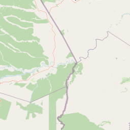
Map view of Madidi National Park

Use this park location map to pinpoint Madidi National Park in Bolivia, understand its exact geographic position, and read its mapped placement within the surrounding landscape more clearly.

Pigeon | © OpenStreetMap contributors

Location context for Madidi National Park

La Paz Department
Park atlas

Browse Surrounding Protected Landscapes and Compare Regional Park Geography Around the Bolivian Andes-Amazon Transition Zone

Explore Other National Parks and Protected Areas Near Madidi National Park in Bolivia
Delve deeper into the rich protected-area tapestry surrounding Madidi National Park, discovering other national parks and reserves across Bolivia's unique Andean and Amazonian landscapes. Compare the diverse park geography and conservation efforts that characterize this biologically rich transboundary region, extending your atlas exploration beyond a single protected entity.
National parkPeru

Bahuaja-Sonene National Park: A Major Amazon Frontier National Park in Peru's Geography

Explore its mapped protected landscape and diverse terrain.

Bahuaja-Sonene National Park is an extensive national park situated on the Amazon frontier in southern Peru, encompassing a crucial transition zone between lowland rainforest and higher-elevation forest ecosystems. Its diverse topography, from river valleys to mountainous slopes, creates varied natural landscapes. The park's protected boundaries are integral to the regional conservation strategy, offering a unique lens through which to study the mapped geography and ecological significance of this vast Amazonian protected area.

Area
10,914.2 km²
Established
1996
IUCN
II
Relief
Mixed relief
National parkLa Paz Department

Cotapata National Park and Integrated Management Natural Area: A Protected Landscape in La Paz Department, Bolivia

Explore its mapped boundaries and regional geographic context.

Delve into the protected landscape identity of Cotapata National Park and Integrated Management Natural Area, situated within the La Paz Department of Bolivia. This entry provides essential geographic context, focusing on its mapped protected area status and its contribution to the regional landscape, ideal for atlas-based exploration and understanding Bolivia's conservation network.

Area
600 km²
Established
1993
IUCN
II
Scope
Terrestrial
National parkBolivia

Isiboro Sécure National Park and Indigenous Territory: Bolivian Protected National Park Atlas

Mapped protected boundaries and regional landscape context.

Investigate Isiboro Sécure National Park and Indigenous Territory as a key protected national park within Bolivia's expansive geography. This resource offers detailed views of its mapped natural landscape and its regional significance as a protected area. Understand the park's geographic attributes and its contribution to the country's conservation atlas through structured map-based exploration.

Area
13,721.8 km²
Established
1965
IUCN
II
Relief
Mixed relief
Watercolor illustration showing a mountain range with green fields, a river, and soft pastel colors
National parkCochabamba Department

Tunari National Park: Protected Landscape Atlas and Geographic Context

Mapped boundaries within Cochabamba Department's geography.

Tunari National Park represents a vital protected landscape within the Cochabamba Department of Bolivia. This page offers an atlas-centric exploration of the park's geographic boundaries, its relationship to the surrounding regional terrain, and its significance as a national park. Delve into the mapped context of Tunari National Park to understand its protected area status and its contribution to Bolivia's diverse geography.

Area
3,090 km²
Established
1992
IUCN
II
Relief
Mountain
National parkCochabamba Department

Carrasco National Park: National Park Status and Protected Landscape Geography

Explore mapped boundaries within Cochabamba Department.

Carrasco National Park, situated within the Cochabamba Department, represents a critical national park entity. This focus provides users with an atlas-centric view of its protected landscape, detailing its geographic significance and mapped features. Understand the park's terrain and regional context, offering a clear perspective on its conservation value and mapped presence.

Area
6,226 km²
Established
1991
IUCN
II
Relief
Mountain
National parkMadre de Dios Region

Manu National Park: A National Park with Mapped Boundaries in Madre de Dios Region

Explore its protected landscape and regional geography.

Gain a detailed understanding of Manu National Park, a key protected area situated in Peru's Madre de Dios Region. This page offers in-depth information on its geographic context, allowing for focused exploration of its mapped terrain and its identity as a national park. Understand how this protected landscape contributes to the regional geography and provides a solid anchor for atlas-based research and discovery.

Area
17,162.9 km²
Established
1973
IUCN
II
Relief
Mixed relief
National parkBolivia

Sajama National Park National Park: Bolivia's Mapped Protected Landscape for Geographic Exploration

Discover regional geography and mapped protected area context.

Sajama National Park represents a crucial protected area within the geography of Bolivia. This MoriAtlas entry focuses on its identity as a national park, detailing its mapped boundaries and its contribution to the regional atlas of protected lands. Understand the park's landscape context and its significance for geographic discovery within South America's diverse terrains.

Area
1,002 km²
Established
1939
IUCN
II
Relief
Mountain
National parkPotosí Department

Torotoro National Park: Paleontology and Karst Landscape Exploration in Bolivia

Discover prehistoric footprints within dramatic Andean canyon geography.

Torotoro National Park in the Potosí Department is a protected area distinguished by its rich paleontological significance and unique semi-arid mountain terrain. Featuring dramatic canyon systems plunging hundreds of meters deep, the park showcases thousands of Cretaceous dinosaur footprints alongside its complex karst topography, complete with caves and sinkholes, offering a profound glimpse into both ancient life and sculpted natural geography.

Area
165 km²
Established
1989
IUCN
II
Relief
Mountain

Common questions about visiting, size, designation, and location context for Madidi National Park

Madidi National Park FAQs for park facts, access, geography, and protected area context
Find quick answers about Madidi National Park, including protected-area facts, park geography, trail and visitor context, and how the park fits into its surrounding country and regional landscape.
MoriAtlas Explorer

Continue Your Protected Areas Search Across the Global Atlas

Deepen your exploration by continuing the structured search for national parks and protected areas worldwide. Utilize the comprehensive filtering capabilities to compare different conservation landscapes and refine your understanding of global park geography. Discover more about the distribution and characteristics of protected natural areas.

Global natural geography