Mori Atlas logo
National parkCotapata National Park and Integrated Management Natural Area

Discover the mapped boundaries and regional context of this significant national park in La Paz Department.

Cotapata National Park and Integrated Management Natural Area: Bolivia's Protected Landscape Geography

(Parque Nacional y Área Natural de Manejo Integrado Cotapata)

Cotapata National Park and Integrated Management Natural Area represents a distinct protected landscape within Bolivia's La Paz Department. This atlas entry focuses on its geographic scope and protected area status, offering clear insights into its mapped boundaries and regional landscape context for a structured understanding of this significant national park.

Bolivia national parksYungas cloud forestAndean protected areasLa Paz Department parksIUCN Category IIIntegrated Management Natural Area

Cotapata National Park and Integrated Management Natural Area

National park

Park overview

Structured park overview, official facts, and landscape profile for Cotapata National Park and Integrated Management Natural Area

Cotapata National Park and Integrated Management Natural Area park facts, protected area profile, and essential visitor context

Review the core facts for Cotapata National Park and Integrated Management Natural Area, including designation, size, terrain, visitor scale, habitats, and operating context in one park-focused overview.

About Cotapata National Park and Integrated Management Natural Area

Cotapata National Park and Integrated Management Natural Area represents Bolivia's commitment to protecting the extraordinary biodiversity of the Yungas, a narrow band of cloud forest that straddles the eastern slopes of the Andes. This protected area encompasses a complex landscape of steep mountain terrain, deep valleys, and forest-covered ridges that characterize the transition between Andean and Amazonian ecological zones. The park's location in the northwestern portion of La Paz Department places it in one of the most geographically diverse regions of Bolivia, where elevational gradients create remarkable habitat diversity within relatively short distances. The Integrated Management designation reflects Bolivia's recognition that effective conservation in populated mountain regions requires balancing ecological protection with the sustainable needs of local communities. The park forms part of a larger network of protected areas that collectively work to preserve the Yungas corridor, which is recognized internationally as a biodiversity hotspot of global significance.

Quick facts and research context for Cotapata National Park and Integrated Management Natural Area

Cotapata National Park lies in the Yungas cloud forest biome of La Paz Department, Bolivia, approximately 50 kilometers from the city of La Paz. The protected area covers roughly 600 square kilometers, representing about 40 percent of the total designated natural area. Established on July 9, 1993 under Decree Supreme Nº23,547, the park is classified as IUCN Category II, indicating its status as a national park with primary protection objectives. The territory spans two provinces, Nor Yungas and Pedro Domingo Murillo, within the Coroico and La Paz municipalities.

Protection and recognition

Documented terrestrial designation frameworks and geographic conservation boundaries

Cotapata National Park and Integrated Management Natural Area Protection Status

Geographic records outline the terrestrial status and designated boundaries established for Cotapata National Park and Integrated Management Natural Area. Evaluating documented designation parameters helps geographers analyze regional conservation frameworks and map terrestrial protected landscapes accurately.

Protection details

Protection scope
Terrestrial
Transboundary protection
No
Park context

Deeper park guide and search-rich context for Cotapata National Park and Integrated Management Natural Area

Cotapata National Park and Integrated Management Natural Area history, landscape, wildlife, and travel context

Explore Cotapata National Park and Integrated Management Natural Area through its history, landscape character, ecosystems, wildlife, conservation priorities, cultural context, and seasonal travel timing in a structured park guide built for atlas discovery and search intent.

Why Cotapata National Park and Integrated Management Natural Area stands out

Cotapata is best known for its preservation of the Yungas cloud forest ecosystem, one of the most ecologically significant and threatened forest types in South America. The park protects a critical corridor of Andean foothill forests that serve as a biodiversity bridge between highland and lowland ecosystems. The region is renowned for its exceptional bird diversity, with numerous endemic species found in the cloud forest canopy and along the park's numerous waterways.

Cotapata National Park and Integrated Management Natural Area history and protected-area timeline

Cotapata National Park was established on July 9, 1993 through Decree Supreme Nº23,547, representing Bolivia's formal recognition of the Yungas region's ecological importance and the need for systematic protection. The creation of the park came during a period of increased environmental awareness in Bolivia during the late 20th century, when the country began expanding its protected area network to cover representative examples of its major ecosystems. The establishment of Cotapata followed the recognition that the Yungas cloud forests faced mounting pressures from agricultural expansion, logging, and infrastructure development. The Integrated Management Natural Area classification reflects a conservation approach that acknowledges the presence of human communities within and adjacent to the park boundaries, incorporating sustainable resource management alongside strict protection zones.

Cotapata National Park and Integrated Management Natural Area landscape and geographic character

The landscape of Cotapata National Park is characterized by the dramatic topography typical of the Yungas region, where the Andes Mountains transition sharply into the Amazon basin. Steep-sided valleys carved by mountain streams descend from the main Andean ridge, creating a terrain of ridges, hollows, and cascading waterways. The forest-covered slopes range from around 1,000 meters to above 3,000 meters in elevation, encompassing multiple ecological zones within the park's boundaries. Mist and clouds are common features of the landscape, particularly during the wet season, giving the Yungas its characteristic cloud forest appearance. The combination of high rainfall, steep terrain, and dense vegetation creates a landscape of exceptional visual diversity, with waterfalls, rock outcrops, and vista points offering striking scenery throughout the park.

Cotapata National Park and Integrated Management Natural Area ecosystems, habitats, and plant life

The Yungas cloud forests that Cotapata protects are among the most species-rich ecosystems in South America, supporting extraordinary levels of biodiversity despite their relatively limited geographic extent. The perpetual cloud cover and high humidity create ideal conditions for epiphytic plants, including numerous orchid and bromeliad species that carpet the forest canopy. The park's elevational range encompasses distinct ecological zones, from foothill forests dominated by hardwood species to higher-elevation cloud forests where mosses and ferns dominate the understory. The Yungas region serves as a critical biogeographic corridor, allowing species to migrate between Andean and Amazonian ecosystems in response to climate shifts. Rivers originating in the park feed into larger watershed systems that provide water resources for downstream communities in the La Paz region.

Cotapata National Park and Integrated Management Natural Area wildlife and species highlights

Cotapata National Park provides crucial habitat for numerous species of fauna, with particular significance for bird populations that depend on the Yungas cloud forest. The region supports over 400 bird species, including several that are endemic to the Yungas and found nowhere else on Earth. Mammals present in the park include various species of monkeys, including squirrel monkeys and howler monkeys that inhabit the forest canopy, along with larger mammals such as jaguars and pumas that require extensive territories. The park's streams and rivers support fish populations and provide habitat for amphibians that thrive in the moist cloud forest environment. Insect diversity is exceptionally high, with countless species of butterflies, beetles, and other invertebrates contributing to the ecosystem's complexity.

Cotapata National Park and Integrated Management Natural Area conservation status and protection priorities

The protection of Cotapata National Park contributes to broader conservation goals for the Yungas ecoregion, which is recognized as a global biodiversity hotspot facing significant threats from human activities. The park forms part of a network of protected areas that collectively aim to preserve the unique Yungas ecosystem, which has been heavily impacted by deforestation for agriculture, particularly in the lower elevations. Conservation efforts in the region address the challenge of protecting biodiversity while acknowledging the presence and needs of local communities who have historically inhabited the area. The Integrated Management approach allows for sustainable use of certain resources while maintaining core protection zones that preserve the most ecologically sensitive areas.

Cotapata National Park and Integrated Management Natural Area cultural meaning and human context

The Yungas region has been inhabited by indigenous communities for centuries, with the local population historically engaged in agriculture, particularly the cultivation of coca leaves and coffee. The area around Cotapata lies within traditional settlement patterns of Aymara-speaking communities who have maintained their connection to the land through generations. The region's proximity to La Paz has influenced its history, with the mountain valleys serving as access routes between the highland capital and the lower-lying Amazonian territories. Contemporary management of the park seeks to respect these historical connections while ensuring the long-term conservation of the region's natural heritage.

Top sights and standout views in Cotapata National Park and Integrated Management Natural Area

Cotapata National Park offers visitors the opportunity to experience one of South America's most biodiverse forest ecosystems relatively close to Bolivia's capital city. The park's trail systems allow exploration of cloud forest habitats, with opportunities to observe endemic bird species and experience the distinctive atmosphere of the Yungas. The dramatic mountain scenery, with its steep ridges and cascading waterfalls, provides scenic rewards for visitors willing to explore the park's interior. The protected area serves as an important watershed, with its forests regulating water flow to communities downstream in the La Paz basin.

Best time to visit Cotapata National Park and Integrated Management Natural Area

The most favorable time to visit Cotapata National Park typically falls during the dry season from May through October, when precipitation is lower and trail conditions are more suitable for hiking. However, the Yungas cloud forest retains its characteristic mist and moisture throughout much of the year, and visitors should be prepared for damp conditions regardless of the season. The wet season from November to April brings higher rainfall, which can make some trails more difficult to navigate but also results in lush, vibrant forest conditions. Birdwatching opportunities may vary seasonally, with some species more readily observable during particular times of year.
Monthly climate preview

Decadal temperature averages and daily precipitation rhythms across the protected terrain

Cotapata National Park and Integrated Management Natural Area Climate Normals

Long term climatology at an elevation of 3230 meters shows a stable thermal pattern with mean temperatures between 8.46 and 11.74 degrees Celsius alongside distinct seasonal precipitation shifts. Comparing the full twelve-month dataset highlights critical variations in monthly minimums, maximums, and daily rainfall averages across the protected terrain.
Annual mean10 °C
8 °C12 °C
Jan11°
Feb11°
Mar11°
Apr11°
May10°
Jun
Jul
Aug
Sep10°
Oct11°
Nov12°
Dec12°
Warmest month
November

11.7 °C

Coolest month
July

8.5 °C

Wettest month
January

4.8 mm/day

Driest month
July

0.5 mm/day

Park location guide

Geography guide, regional context, and park location map for Cotapata National Park and Integrated Management Natural Area

Cotapata National Park and Integrated Management Natural Area park geography, regions, and map view in Bolivia

Understand where Cotapata National Park and Integrated Management Natural Area sits in Bolivia through a broader geographic reading of the surrounding landscape, nearby location context, and its mapped position within the national park landscape.

How Cotapata National Park and Integrated Management Natural Area fits into Bolivia

Bolivia, officially the Plurinational State of Bolivia, is a landlocked country in central South America. It features diverse geography including the Andean mountain range, Amazonian plains, Gran Chaco, and the Pantanal wetland. The country has a population of approximately 11.4 million and is administratively divided into nine departments, with La Paz as the seat of government and Sucre as the constitutional capital.

Wider geography shaping Cotapata National Park and Integrated Management Natural Area in Bolivia

Bolivia is located in central South America, bordered by Brazil to the north and east, Paraguay to the southeast, Argentina to the south, Chile to the southwest, and Peru to the west. The country is divided between a western Andean region and tropical lowlands to the east and north. It includes the Amazonian plain, Gran Chaco, temperate valleys, the high-altitude Altiplano plateau, and part of the Pantanal wetland along its eastern border.

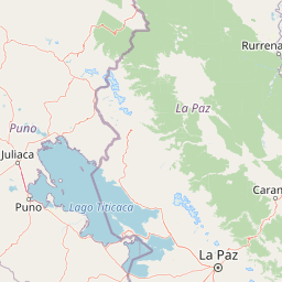
Map view of Cotapata National Park and Integrated Management Natural Area

Use this park location map to pinpoint Cotapata National Park and Integrated Management Natural Area in Bolivia, understand its exact geographic position, and read its mapped placement within the surrounding landscape more clearly.

Pigeon | © OpenStreetMap contributors

Location context for Cotapata National Park and Integrated Management Natural Area

La Paz Department
Recorded earthquake history

Review Cotapata National Park and Integrated Management Natural Area Seismic History

Explore a detailed record of seismic events associated with the surrounding geography of this protected area. MoriAtlas provides a clear, data-driven catalogue of historical earthquakes that have occurred near the park, allowing for a better understanding of regional seismic activity patterns.

Cotapata National Park Earthquake History

Catalogued events

4 events

Strongest magnitude

Magnitude 4.9

Most recent event

Nov 18, 2014

This history includes earthquakes recorded inside the park or within 50 km of its borders

Park atlas

Browse surrounding protected landscapes and compare Andean cloud forest ecosystems across Bolivia.

Explore Other National Parks and Protected Areas Near Cotapata National Park and Integrated Management Natural Area

Browse other national parks and protected areas related to Cotapata National Park and Integrated Management Natural Area, tracing their geographic spread across Bolivia's Yungas region. Compare nearby mountain forests, high-altitude Andean ecosystems, and critical biodiversity hotspots to gain broader regional context for conservation efforts and varied terrain.
National parkLa Paz
About 18 km away#1 closest

West

Parque Nacional Tuni Condoriri: Geographic Atlas of the Cordillera Real Protected Landscape

High-altitude mountain terrain and glacial lake systems in Bolivia

Spanning elevations between 4,500 and 6,200 meters, Parque Nacional Tuni Condoriri represents a primary example of high-Andean topography. The landscape is defined by the serrated Condoriri massif, a series of interconnected glacial lakes, and expansive high-altitude grasslands. This protected area remains a focal point for understanding the hydrological and geological processes shaping the mountain environments of the La Paz region.

Area
91.75 km²
Established
1942
Relief
Mountain
Climate
Alpine
National parkLa Paz Department
95 km away#2 closest

North

Madidi National Park: National Park Protected Landscape and Geographic Atlas Entry

Explore mapped boundaries and regional context in La Paz Department.

Madidi National Park is a designated national park situated in Bolivia's La Paz Department. This detail entry offers a focused perspective on its protected landscape, its specific geographic setting, and its role within the larger atlas of natural areas. Understand the park's mapped boundaries and its contribution to the regional geography, providing a foundation for structured discovery of Bolivia's protected lands.

Area
18,957.5 km²
Established
1995
IUCN
II
Relief
Mixed relief
Biosphere reserveBolivia
About 141 km away#3 closest

Northeast

Reserva de la Biosfera y Tierra Comunitaria de Origen Pilón Lajas Protected Landscape Atlas

Mapping the Andean Amazonian transition in northern Bolivia

Spanning from high mountain ridges to the river plains of the Beni, this protected area features a unique vertical gradient of ecosystems including cloud forests and terra firme. It represents a significant model for indigenous co governance and biodiversity protection within the broader Andean and Amazonian geographic context.

Area
4,000 km²
Established
1992
Relief
Mountain
Climate
Tropical
Watercolor illustration showing a mountain range with green fields, a river, and soft pastel colors
National parkCochabamba Department
151 km away#4 closest

Southeast

Tunari National Park: Protected Landscape Atlas and Geographic Context

Mapped boundaries within Cochabamba Department's geography.

Tunari National Park represents a vital protected landscape within the Cochabamba Department of Bolivia. This page offers an atlas-centric exploration of the park's geographic boundaries, its relationship to the surrounding regional terrain, and its significance as a national park. Delve into the mapped context of Tunari National Park to understand its protected area status and its contribution to Bolivia's diverse geography.

Area
3,090 km²
Established
1992
IUCN
II
Relief
Mountain
Protected areaBolivia
About 154 km away#5 closest

Northwest

Área Natural de Manejo Integrado Apolobamba: Protected Landscape Geography and Andean Terrain

High-altitude glacial geography and Andean-Amazonian transition zones

Located in the department of La Paz, this protected area features a rugged landscape defined by tectonic uplift and Quaternary glaciation. It safeguards critical high-Andean habitats, including peatlands and Polylepis woodlands, while providing a essential refuge for vicuña populations within its steeply dissected mountain topography.

Area
4,837.43 km²
Established
1972
Relief
Mountain
Climate
Alpine
National parkBolivia
About 191 km away#6 closest

East

Isiboro Sécure National Park and Indigenous Territory: Bolivian Protected National Park Atlas

Mapped protected boundaries and regional landscape context.

Investigate Isiboro Sécure National Park and Indigenous Territory as a key protected national park within Bolivia's expansive geography. This resource offers detailed views of its mapped natural landscape and its regional significance as a protected area. Understand the park's geographic attributes and its contribution to the country's conservation atlas through structured map-based exploration.

Area
13,721.8 km²
Established
1965
IUCN
II
Relief
Mixed relief
National parkBolivia
207 km away#7 closest

Southwest

Sajama National Park National Park: Bolivia's Mapped Protected Landscape for Geographic Exploration

Discover regional geography and mapped protected area context.

Sajama National Park represents a crucial protected area within the geography of Bolivia. This MoriAtlas entry focuses on its identity as a national park, detailing its mapped boundaries and its contribution to the regional atlas of protected lands. Understand the park's landscape context and its significance for geographic discovery within South America's diverse terrains.

Area
1,002 km²
Established
1939
IUCN
II
Relief
Mountain
Protected areaBeni Department
About 221 km away#8 closest

North

Área Protegida Municipal Rhukanrhuka: Mapping Amazonian Biodiversity and Riverine Terrain

A transitional protected landscape in the Beni Department of Bolivia

Spanning a vast transition from Andean slopes to the Llanos de Moxos floodplain, Área Protegida Municipal Rhukanrhuka protects a dynamic mosaic of white-water rivers, gallery forests, and tectonic lakes. This significant municipal reserve serves as a refuge for threatened species and sustains indigenous Maropa communities within its borders, anchoring an essential conservation corridor in the northern Amazon.

Area
8,594.51 km²
Established
2019
Relief
Lowland
Climate
Tropical

Common questions about visiting, size, designation, and location context for Cotapata National Park and Integrated Management Natural Area

Cotapata National Park and Integrated Management Natural Area FAQs for park facts, access, geography, and protected area context

Find quick answers about Cotapata National Park and Integrated Management Natural Area, including protected-area facts, park geography, trail and visitor context, and how the park fits into its surrounding country and regional landscape.
MoriAtlas Explorer

Continue Your Protected Areas Search Across the Global Atlas

Deepen your exploration by continuing the structured search for national parks and protected areas worldwide. Utilize the comprehensive filtering capabilities to compare different conservation landscapes and refine your understanding of global park geography. Discover more about the distribution and characteristics of protected natural areas.

Global natural geography