

Mori Atlas logo
National parkTunari National Park

Mapped boundaries and regional geographic context for this Bolivian national park.

Tunari National Park: National Park Protected Landscape Atlas and Geography

Tunari National Park stands as a significant protected area within Bolivia's Cochabamba Department, offering a unique vantage point for exploring natural landscapes and mapped geography. This dedicated entry provides an atlas-focused view of the park's protected boundaries, highlighting its regional setting and contributing to a broader understanding of conservation landscapes. Discover the geographic identity of Tunari National Park, a key component of Bolivia's protected areas.

Andean ecosystemsmountain protected areaBolivia national parkshighland conservationTunari Mountain Rangewatershed protection
Illustration of a mountainous landscape with cliffs, valleys, forests, and a waterfall under a partly cloudy sky

Tunari National Park

National park

Park overview

Structured park overview, official facts, and landscape profile for Tunari National Park

Tunari National Park park facts, protected area profile, and essential visitor context

Review the core facts for Tunari National Park, including designation, size, terrain, visitor scale, habitats, and operating context in one park-focused overview.

About Tunari National Park

Tunari National Park represents an important protected area in Bolivia's central highlands, established to preserve the natural integrity of the Tunari Mountain Range and its surrounding ecosystems. The park encompasses approximately 3,090 square kilometers of mountainous terrain, making it one of the larger protected areas in the Cochabamba Department. The landscape is characterized by rugged mountain terrain, deep valleys, and high-altitude plateaus typical of the Andean interior. The protected area serves multiple conservation functions, including watershed protection, biodiversity preservation, and maintenance of scenic landscapes that hold ecological and cultural significance for local communities. The park's establishment in 1992 reflected Bolivia's commitment to expanding its protected areas network during that period of national environmental policy development. However, the park faces ongoing environmental pressures, most notably from the Misicuni Dam project which, when completed, would flood significant portions of the park's territory, raising concerns about the long-term viability of the protected area's ecological integrity.

Quick facts and research context for Tunari National Park

Tunari National Park covers roughly 3,090 square kilometers in the central Bolivian highlands, centered on the Tunari Mountain Range in Cochabamba Department. The park was formally established in 1992 under Bolivia's national protected areas system. It is classified as an IUCN Category II protected area, reflecting its national park status and primary conservation purpose. The governing body is the Servicio Nacional de Áreas Protegidas (SENAP), Bolivia's national parks service. The park sits at coordinates approximately 17.25°S and 66.33°W in the Andean foothills.

Protection and recognition

Verifying official terrestrial protection records and global conservation registry status

Tunari National Park Protection Status and Conservation Designation

Analyze the official protection status and documented management framework established to safeguard the terrestrial environment of Tunari National Park. Accessing verified database records and global conservation registries provides clear geographic context regarding the official protection level of crucial regional landscapes.

Protection details

Protection scope
Terrestrial
Park context

Deeper park guide and search-rich context for Tunari National Park

Tunari National Park history, landscape, wildlife, and travel context

Explore Tunari National Park through its history, landscape character, ecosystems, wildlife, conservation priorities, cultural context, and seasonal travel timing in a structured park guide built for atlas discovery and search intent.

Why Tunari National Park stands out

Tunari National Park is best known for its dramatic mountain landscapes within the Tunari Mountain Range, one of the prominent highland systems in central Bolivia. The park protects diverse Andean ecosystems ranging from cloud forests in the lower elevations to alpine grasslands and rocky terrain at higher altitudes. It serves as an important watershed area providing water resources for the Cochabamba region and supports biodiversity characteristic of Bolivia's montane environments. The park's proximity to Cochabamba also makes it a significant green space for the region's residents.
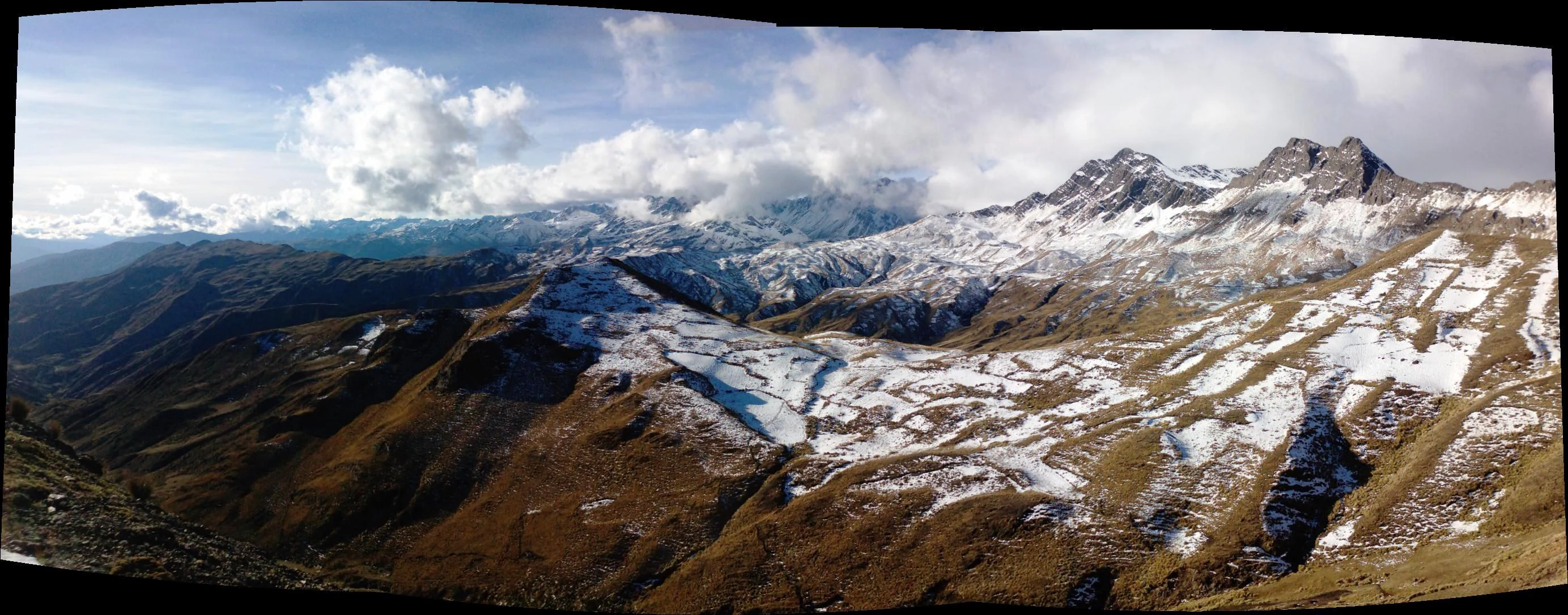
Panoramic landscape of snow-covered mountain peaks and rocky valleys under a partly cloudy sky
Panoramic view of Tunari Mountain range with snow-capped peaks and valleys under a partly cloudy sky

Tunari National Park history and protected-area timeline

Tunari National Park was established in 1992 as part of Bolivia's expanding national protected areas system during a period of increased environmental conservation activity in the country. The creation of the park reflected growing recognition of the need to protect the unique Andean ecosystems found in the Tunari Mountain Range, which represents a significant geographic feature in central Bolivia. The protected area was designated under Bolivia's protected areas legislation and placed under the management of the Servicio Nacional de Áreas Protegidas (SENAP), the national agency responsible for administering Bolivia's parks and reserves. The park's establishment came during a broader era of protected area expansion in Bolivia during the 1990s, when numerous new national parks and reserves were created to address biodiversity conservation concerns and fulfill international environmental commitments.

Tunari National Park landscape and geographic character

The Tunari National Park landscape is dominated by the Tunari Mountain Range, a prominent mountainous system in Bolivia's central highlands. The terrain features steep peaks, ridgelines, and valleys that characterize the Andean foothills in this region. Elevation ranges across the park create distinct environmental zones, from lower elevation areas supporting vegetation communities to higher alpine zones with rocky outcrops and grassland ecosystems. The mountainous topography influences local climate patterns and hydrology, with the range serving as an important watershed that channels water flow toward the surrounding lowlands and ultimately into larger river systems. The visual character of the park combines the dramatic silhouettes of Andean peaks with the more gentle contours of high-altitude grasslands and the denser vegetation found in sheltered valleys and cloud forest zones.

Tunari National Park ecosystems, habitats, and plant life

The ecosystems within Tunari National Park represent typical Andean environmental zones found in central Bolivia's highland regions. Montane grassland ecosystems dominate the higher elevations, characterized by tough grasses adapted to cool, often windy conditions. Cloud forest communities develop on the more humid slopes where moisture from intercepted cloud cover creates conditions suitable for denser forest growth. These forests typically feature a mix of tree species adapted to the subtropical highland environment, with epiphytes, ferns, and other moisture-loving plants contributing to the ecological complexity. The park's location within the broader Andean biodiversity hotspot means it supports species found nowhere else on Earth, though the specific species composition reflects the elevational range and geographic isolation of the Tunari Range. Watershed and hydrological functions are particularly important, with the park's terrain playing a role in water capture and storage that supports downstream water users in the Cochabamba region.

Tunari National Park wildlife and species highlights

The wildlife within Tunari National Park reflects the Andean character of the protected area, with species assemblages typical of Bolivia's highland environments. Birdlife includes various highland species adapted to grassland and rocky terrain habitats, while forest-dwelling species occupy the cloud forest zones in the more vegetated areas. The park likely supports populations of characteristic Andean mammals including various rodent species, Andean foxes, and possibly larger mammals such as deer species that inhabit the higher elevation zones. Reptile and amphibian diversity would be influenced by the availability of moisture in different habitat zones, with more species found in the humid forest areas and fewer in the more arid highland sections. The specific wildlife communities depend heavily on the habitat preservation maintained by the protected area status, which provides refuge from hunting and habitat conversion pressures that affect many other areas in the Cochabamba region.

Tunari National Park conservation status and protection priorities

Tunari National Park serves important conservation functions for Bolivia's central highlands, protecting representative examples of Andean mountain ecosystems within a region that has experienced significant human modification. The park's designation as an IUCN Category II protected area reflects its primary purpose of preserving natural landscapes and the biodiversity they support. Beyond species protection, the park provides critical watershed services, maintaining hydrological functions that benefit downstream users including the Cochabamba metropolitan area. However, the park's conservation status faces serious challenges from the planned Misicuni Dam project. When completed, the dam would flood portions of the protected area, directly contradicting the conservation principles underlying the park's establishment. This development pressure highlights the ongoing tension between infrastructure development and environmental protection in Bolivia, and raises questions about the long-term effectiveness of the protected area designation.

Tunari National Park cultural meaning and human context

The Tunari Mountain Range holds cultural significance for local communities in the Cochabamba region, reflecting the deep connections between Andean peoples and their highland environment. The landscapes within the park area have been part of the cultural geography of central Bolivia long before the protected area was established, with traditional land use practices shaped by the opportunities and constraints of the mountain environment. Communities in the surrounding areas maintain relationships with the land that include historical patterns of pastoral activity, agricultural use of valley floors and lower slopes, and resource collection from higher elevation zones. The park's establishment created new management frameworks that affect how these traditional relationships with the landscape can continue, requiring ongoing attention to how conservation objectives interact with community needs and cultural practices.

Top sights and standout views in Tunari National Park

Tunari National Park's primary highlight is the dramatic Tunari Mountain Range itself, a defining geographic feature of central Bolivia that provides scenic backdrop to the Cochabamba region. The park protects significant examples of Andean highland ecosystems, from cloud forests to alpine grasslands, within a relatively accessible distance from a major population center. The watershed functions of the mountain range represent an essential ecosystem service, providing water capture and regulation that supports thousands of people downstream. The park also represents Bolivia's conservation commitment in its central highlands, demonstrating the country's effort to preserve representative examples of its diverse environmental heritage. However, the ongoing threat from the Misicuni Dam project serves as a notable concern rather than highlight, as it poses direct risk to the park's ecological integrity.

Best time to visit Tunari National Park

The best time to visit Tunari National Park depends on the seasonal climate patterns of the Bolivian highlands. The dry season from May to October generally offers more stable weather conditions with clearer skies, though temperatures can be quite cold at higher elevations, especially during night hours. The wet season from November through April brings increased precipitation, which can make some trails more difficult to traverse but also brings lusher vegetation and more dramatic cloud formations in the mountain zones. Visitors interested in wildlife viewing may find different species more active during different seasons, while those concerned with scenic photography may prefer the clearer conditions of the dry season. The proximity to Cochabamba means the park can be visited as a day trip or extended excursion, though facilities within the protected area are likely limited.

Monthly climate preview

Long term temperature profiles and precipitation rhythms in the Cochabamba Department.

Tunari National Park Monthly Weather Normals and Climate Geography

Long term measurements at a representative elevation of 3,321 meters reveal that Tunari National Park experiences average monthly temperatures between 7.4 and 11.5 degrees Celsius. Accessing the complete twelve month dataset reveals detailed minimum and maximum temperature spreads alongside daily precipitation averages for deeper geographic comparison.
Annual mean10 °C
7 °C12 °C
Jan11°
Feb11°
Mar11°
Apr10°
May
Jun
Jul
Aug
Sep10°
Oct11°
Nov11°
Dec12°
Warmest month
December

11.5 °C

Coolest month
July

7.5 °C

Wettest month
January

3.8 mm/day

Driest month
July

0.2 mm/day

Park location guide

Geography guide, regional context, and park location map for Tunari National Park

Tunari National Park park geography, regions, and map view in Bolivia

Understand where Tunari National Park sits in Bolivia through a broader geographic reading of the surrounding landscape, nearby location context, and its mapped position within the national park landscape.

How Tunari National Park fits into Bolivia

Bolivia, officially the Plurinational State of Bolivia, is a landlocked country in central South America. It features diverse geography including the Andean mountain range, Amazonian plains, Gran Chaco, and the Pantanal wetland. The country has a population of approximately 11.4 million and is administratively divided into nine departments, with La Paz as the seat of government and Sucre as the constitutional capital.

Wider geography shaping Tunari National Park in Bolivia

Bolivia is located in central South America, bordered by Brazil to the north and east, Paraguay to the southeast, Argentina to the south, Chile to the southwest, and Peru to the west. The country is divided between a western Andean region and tropical lowlands to the east and north. It includes the Amazonian plain, Gran Chaco, temperate valleys, the high-altitude Altiplano plateau, and part of the Pantanal wetland along its eastern border.

Map view of Tunari National Park

Use this park location map to pinpoint Tunari National Park in Bolivia, understand its exact geographic position, and read its mapped placement within the surrounding landscape more clearly.

Pigeon | © OpenStreetMap contributors

Location context for Tunari National Park

Cochabamba Department
Recorded earthquake history

Explore the Historical Earthquake Records for Tunari National Park

Access the MoriAtlas archive to review recorded seismic events in the vicinity of the Tunari Mountain Range. Analyze historical magnitude, depth, and distance data for earthquake activity documented near the boundaries of this protected Bolivian landscape to better understand the regional seismic profile.

Tunari National Park Earthquake Records

Catalogued events

29 events

Strongest magnitude

Magnitude 6.2

Most recent event

May 16, 2026

This history includes earthquakes recorded inside the park or within 50 km of its borders

Explore Bolivia's Tunari National Park: Visualizing Andean Highland Ecosystems and Mountain Landscapes

Discover Tunari National Park Photos: Landscapes, Scenery, and Protected Area Views

Browse a curated collection of Tunari National Park photos to visually understand its dramatic mountain landscapes and diverse Andean ecosystems. Explore the visual character of its protected terrain, offering key insights into the highland scenery and unique habitats of central Bolivia.

Panoramic landscape of snow-covered mountain peaks and rocky valleys under a partly cloudy sky

Park atlas

Compare additional protected landscapes and trace the regional park geography across Bolivia's central highlands.

Browse National Parks and Protected Areas Near Tunari National Park, Bolivia

Continue your exploration of Bolivia's protected areas by browsing other national parks and protected landscapes found near Tunari National Park in the central highlands. Mapping these adjacent conservation zones provides valuable geographic context for comparing diverse Andean ecosystems and understanding the broader regional spread of protected terrain.
National parkCochabamba Department
11 km away#1 closest

East

Carrasco National Park: National Park Status and Protected Landscape Geography

Explore mapped boundaries within Cochabamba Department.

Carrasco National Park, situated within the Cochabamba Department, represents a critical national park entity. This focus provides users with an atlas-centric view of its protected landscape, detailing its geographic significance and mapped features. Understand the park's terrain and regional context, offering a clear perspective on its conservation value and mapped presence.

Area
6,226 km²
Established
1991
IUCN
II
Relief
Mountain
National parkPotosí Department
About 81 km away#2 closest

Southeast

Torotoro National Park: Paleontology and Karst Landscape Exploration in Bolivia

Discover prehistoric footprints within dramatic Andean canyon geography.

Torotoro National Park in the Potosí Department is a protected area distinguished by its rich paleontological significance and unique semi-arid mountain terrain. Featuring dramatic canyon systems plunging hundreds of meters deep, the park showcases thousands of Cretaceous dinosaur footprints alongside its complex karst topography, complete with caves and sinkholes, offering a profound glimpse into both ancient life and sculpted natural geography.

Area
165 km²
Established
1989
IUCN
II
Relief
Mountain
National parkBolivia
About 104 km away#3 closest

North

Isiboro Sécure National Park and Indigenous Territory: Bolivian Protected National Park Atlas

Mapped protected boundaries and regional landscape context.

Investigate Isiboro Sécure National Park and Indigenous Territory as a key protected national park within Bolivia's expansive geography. This resource offers detailed views of its mapped natural landscape and its regional significance as a protected area. Understand the park's geographic attributes and its contribution to the country's conservation atlas through structured map-based exploration.

Area
13,721.8 km²
Established
1965
IUCN
II
Relief
Mixed relief
National parkSanta Cruz Department
141 km away#4 closest

East

Amboró National Park: Its Protected Area Identity and Geographic Context

Mapped boundaries and regional landscape details.

Amboró National Park is a designated national park situated within the Santa Cruz Department, Bolivia. This entry provides detailed insights into its protected landscape, focusing on its geographical significance and mapped boundaries. Users can explore how Amboró National Park fits into the broader regional geography, enhancing their understanding of conservation areas and mapped natural terrains for atlas-based research and discovery. Its specific location and protected status are crucial for understanding its ecological and geographic role.

Area
4,425 km²
Established
1984
IUCN
II
Relief
Mountain
National parkLa Paz Department
151 km away#5 closest

Northwest

Cotapata National Park and Integrated Management Natural Area: A Protected Landscape in La Paz Department, Bolivia

Explore its mapped boundaries and regional geographic context.

Delve into the protected landscape identity of Cotapata National Park and Integrated Management Natural Area, situated within the La Paz Department of Bolivia. This entry provides essential geographic context, focusing on its mapped protected area status and its contribution to the regional landscape, ideal for atlas-based exploration and understanding Bolivia's conservation network.

Area
600 km²
Established
1993
IUCN
II
Scope
Terrestrial
Protected areaCochabamba
About 153 km away#6 closest

Southeast

Area Natural Lagarpampa: Protected Inter-Andean Landscapes and Regional Geography

Community-led conservation in the Cochabamba dry valleys.

Spanning over thirty thousand hectares, Area Natural Lagarpampa serves as a significant example of community-driven land protection. The geography features an intricate mix of semi-arid slopes, seasonally active watercourses, and dry-forest ravines that define this part of the Cochabamba highlands. This landscape supports a vital population of the red-fronted macaw, illustrating the intersection between rural agricultural heritage and specialized ecological preservation within the Andean valley system.

Area
303.08 km²
Established
2009
Relief
Upland
Climate
Arid
Protected landscapeChuquisaca
About 177 km away#7 closest

Southeast

Área natural de manejo integrado El Palmar: Protected Landscape Geography and Map

Andean mountain ecosystems and endemic palm habitat in Chuquisaca.

Investigate the complex geomorphology of Área natural de manejo integrado El Palmar, a protected area in the Cordillera Oriental of Bolivia. This atlas resource covers the interplay between high-altitude serranías, palm-filled quebradas, and the cultural heritage of the Yampara nation, offering a structured look at its protected boundaries and diverse Andean environment.

Area
594.8 km²
Established
1997
Relief
Mountain
Climate
Mediterranean
National parkLa Paz
About 186 km away#8 closest

Northwest

Parque Nacional Tuni Condoriri: Geographic Atlas of the Cordillera Real Protected Landscape

High-altitude mountain terrain and glacial lake systems in Bolivia

Spanning elevations between 4,500 and 6,200 meters, Parque Nacional Tuni Condoriri represents a primary example of high-Andean topography. The landscape is defined by the serrated Condoriri massif, a series of interconnected glacial lakes, and expansive high-altitude grasslands. This protected area remains a focal point for understanding the hydrological and geological processes shaping the mountain environments of the La Paz region.

Area
91.75 km²
Established
1942
Relief
Mountain
Climate
Alpine

Common questions about visiting, size, designation, and location context for Tunari National Park

Tunari National Park FAQs for park facts, access, geography, and protected area context

Find quick answers about Tunari National Park, including protected-area facts, park geography, trail and visitor context, and how the park fits into its surrounding country and regional landscape.
MoriAtlas Explorer

Continue Your Protected Areas Search Across the Global Atlas

Deepen your exploration by continuing the structured search for national parks and protected areas worldwide. Utilize the comprehensive filtering capabilities to compare different conservation landscapes and refine your understanding of global park geography. Discover more about the distribution and characteristics of protected natural areas.

Global natural geography