Mori Atlas logo
Protected areaÁrea Protegida Municipal Rhukanrhuka

Tracing the transition from Andean foothills to the vast riverine plains of Beni

Geographic Atlas and Mapped Landscapes of Área Protegida Municipal Rhukanrhuka in Bolivia

(Parque Municipal y Área Natural de Manejo Integrado Rhukanrhuka)

Área Protegida Municipal Rhukanrhuka represents a vital ecological bridge in the northern Bolivian Amazon where Andean-derived white-water rivers meet the expansive tectonic lakes and savanna mosaics of the Llanos de Moxos. This protected landscape encompasses a complex hydrological network including the Beni, Biata, and Hondo river corridors alongside significant water bodies like Lago Rogagua. The area functions as a critical sanctuary for endemic primates and rare bird populations, documenting the interplay between diverse Amazonian terrain and indigenous Tacana-language cultural territory.

Amazon rainforestwetlandswhite-water riverstectonic lakesgallery forestssavanna mosaic

Área Protegida Municipal Rhukanrhuka

Protected area

Park overview

Structured park overview, official facts, and landscape profile for Rhukanrhuka Municipal Protected Area

Rhukanrhuka Municipal Protected Area park facts, protected area profile, and essential visitor context

Review the core facts for Rhukanrhuka Municipal Protected Area, including designation, size, terrain, visitor scale, habitats, and operating context in one park-focused overview.

About Rhukanrhuka Municipal Protected Area

Rhukanrhuka Municipal Protected Area represents one of the largest municipal-scale conservation initiatives in the Bolivian Amazon. Located in the municipality of Reyes in the province of General José Ballivián, Beni department, it embodies both a conservation strategy and a recognition of the region's ecological and cultural importance at the bottom of the Andes and the top of the Llanos de Moxos.

The protected area occupies the southern half of the Reyes municipality and covers ecosystems that transition from the last Andean foothills into the flooded plains of the Moxos region. This geographic position places it within the mid-to-upper Madeira river basin, where the Beni and Mamoré sub-basins converge. White-water rivers fed by Andean erosion sculpt the western and southern landscape, while large tectonic lakes and savanna patches further east add complexity. The result is an unusually varied habitat matrix of gallery forests, riparian corridors, non-alcaline savannas, and seasonal floodplains.

Ecologically, Rhukanrhuka reflects the rapid biogeographic gradient typical of northern Bolivia. Although detailed biological inventories are still scarce, projections based on existing data and information from the Wildlife Conservation Society (WCS) suggest roughly 190 mammal species, 636 bird species, 162 reptile species, and 84 amphibian species may occur there, alongside around 220 fish species. These figures underline how the area functions as a biological bridge between Andean, piedmont, and lowland Amazonian ecosystems.

The protected area is integral to Bolivian conservation policy from both ecological and cultural perspectives. It hosts several species of high national and global concern, including the critically endangered wattled curassow, the two endemic Bolivian titi monkeys, the Bolivian river dolphin (bufeo), jaguar, puma, lowland tapir, marsh deer, and Bolivian anaconda. Recognizing its importance, the upper Río Negro basin within Rhukanrhuka has been formally classified as an Important Bird Area. Culturally, the area is home to the Maropa people, a Tacana-language indigenous community, and contains the Uaua-Uno archaeological site, the only such site in the broader region that has been studied, rescued in 2004.

Adjacent to the Bajo Madidi municipal conservation area and lying in close proximity to Madidi National Park, one of the most biodiverse protected areas on Earth, Rhukanrhuka extends the conservation corridor that links the Andes with the heart of the southern Amazon, while still operating under the local governance framework of the Reyes municipal government.

Quick facts and research context for Rhukanrhuka Municipal Protected Area

Administratively, Rhukanrhuka is a municipal protected area (Área Protegida Municipal) under the Government of Reyes, created in June 2019 through Municipal Law N°197. It covers more than 8,500 square kilometers within the northern Bolivian Amazon, spanning altitudes around 189 meters above sea level and ranging from the last Andean foothills to the floodplains of the Llanos de Moxos.

The area lies within the mid-to-upper Madeira river basin, between the Beni and Mamoré sub-basins, and is drained by white-water rivers such as the Beni, Biata, and Hondo, together with tectonic lakes aligned along the Bala-Rogagua line, including Lago Rogagua. It borders the Bajo Madidi municipal conservation area to the west, sits roughly 11 kilometers from Madidi National Park, and is bordered to the east by the Pampas del Río Yacuma municipal protected area.

Protection and recognition

Examine terrestrial protection scope, designation year, and documented recognition data.

Área Protegida Municipal Rhukanrhuka Protection Status and Designation History

Terrestrial protection status for Área Protegida Municipal Rhukanrhuka was established in 2019 under municipal authority. Official designation records detail the established conservation framework without international recognition sources.

Protection details

Protection scope
Terrestrial
Designated year
2019
Transboundary protection
No
Park context

Deeper park guide and search-rich context for Rhukanrhuka Municipal Protected Area

Rhukanrhuka Municipal Protected Area history, landscape, wildlife, and travel context

Explore Rhukanrhuka Municipal Protected Area through its history, landscape character, ecosystems, wildlife, conservation priorities, cultural context, and seasonal travel timing in a structured park guide built for atlas discovery and search intent.

Why Rhukanrhuka Municipal Protected Area stands out

Rhukanrhuka is best known as a transition-zone reserve where Andean foothills give way to the vast Llanos de Moxos, creating a mosaic of white-water riverine forests, non-alcaline savannas, and tectonic lakes. It is especially recognized for harboring one of the few documented populations of the wattled curassow (pava mamaco) in Bolivia, concentrated in the upper Río Negro basin. The area is equally distinguished as a refuge for Bolivia's two endemic titi monkeys, the reddish lucachi (Callicebus olallae) and the grayish lucachi (Callicebus modestus), which inspired the Maropa name of the protected area itself. The combination of threatened primates, endemic curassow populations, Andean-origin rivers, and indigenous Maropa territory gives Rhukanrhuka a clearly defined ecological and cultural identity within Bolivia's northern Amazon.
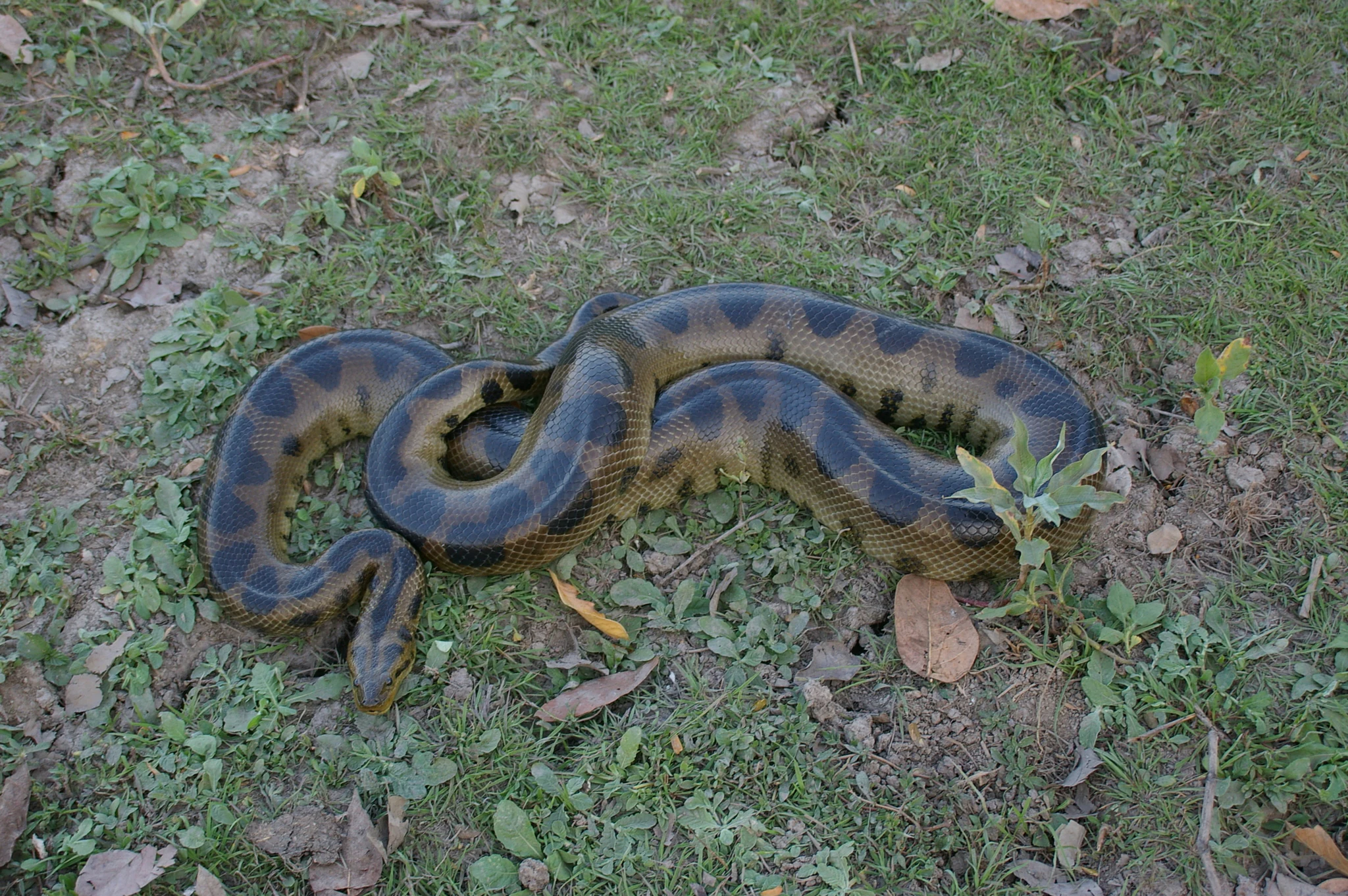
An anaconda with dark oval spots on its scales is coiled on a patch of grass and dirt.
A Beni anaconda resting on the ground in the Rhukanrhuka protected area.

Rhukanrhuka Municipal Protected Area history and protected-area timeline

The origins of Rhukanrhuka as a formally recognized protected area date back to a 2008 proposal by the municipal government of Reyes, which approved the creation of the Área Protegida Municipal Los Santos Reyes. That initiative aimed to promote tourism and conserve the natural resources of the municipality, but it failed to develop a stable legal foundation, did not carry out adequate consultation with local communities, and lacked management instruments.

In 2018, the proposal was reopened with a broader, more participatory approach. Local actors from different sectors of Reyes came together to revise the framework, and on 25 June 2019, the Área Protegida Municipal Rhukanrhuka was formally created through Municipal Law N°197. The new designation was inspired by the Maropa indigenous name for the lucachi monkeys, two species of titi monkeys endemic to Bolivia that live within the area, an intentional alignment between the park's identity and the indigenous cultural presence in its territory.

The creation of Rhukanrhuka marked a shift from a top-down tourism-oriented proposal to a more inclusive municipal conservation strategy. It also positioned Reyes alongside other Bolivian municipalities, such as Ixiamas and Santa Rosa de Yacuma, that have used municipal protected areas as instruments of decentralized biodiversity conservation in the northern Amazon.

Rhukanrhuka Municipal Protected Area landscape and geographic character

Rhukanrhuka occupies a broad transitional zone in the northern Bolivian Amazon, where the easternmost foothills of the Andes gradually disappear into the vast Llanos de Moxos floodplain. The terrain is relatively flat on a regional scale, reflecting the lowland character of the Beni department, but it is far from monotonous: small variations in elevation, river systems, geological substrates, and hydrology produce striking ecological contrast.

Hydrography shapes the landscape more than topography does. The protected area lies in the mid-to-upper portion of the Madeira river basin, between the sub-basins of the Beni and Mamoré rivers. White-water rivers originating from Andean erosion, including the Beni along the western boundary, the Biata crossing from southwest to northeast, and the Hondo in the south, carry heavy sediment loads that give their waters their characteristic turbid, light "white" color. These rivers cut through the forests and create extensive riverine corridors.

Meanwhile, the eastern part of Rhukanrhuka features a chain of deep tectonic lakes formed by the collapse of underlying bedrock along the Bala-Rogagua line. The largest of these is Lago Rogagua, followed by lakes such as San Lorenzo and Yusala. Their waters, like those of the surrounding rivers, are strongly seasonal, fluctuating with rainfall and the flooding cycles of the southern Amazon. Together, the erosional rivers of the west and the tectonic lakes of the east define a landscape that merges fluvial, lacustrine, and savanna environments into a single dynamic mosaic.

Rhukanrhuka Municipal Protected Area ecosystems, habitats, and plant life

Vegetation in Rhukanrhuka expresses the same transition that defines its physical setting. Roughly 19 vegetation units have been identified in the protected area, with forests of various types covering around 60 percent of the surface and savannas covering another 30 percent. Vegetation tied directly to rivers, lakes, and wetlands accounts for about 5 percent, while human-modified areas remain under half a percent, illustrating how the landscape is still largely in natural condition.

The most extensive forest formations are the complex of gallery and riparian vegetation associated with the white-water rivers of the Beni system, together with non-alcaline savannas of Beni that transition toward cerrado ecosystems. Forests are typically concentrated along the Beni and Río Negro corridors, while savannas dominate the central and eastern sectors. The combination of these formations creates a high-value habitat mosaic that supports both forest-dependent species and those adapted to open landscapes.

Floristic data on Rhukanrhuka are still developing, but historical riverine forest surveys show high species richness with a strong presence of legumes and palms. Local communities also use and recognize species such as motacú (a native palm), cacao, guayaba, and achachairú, while historically valuable timber species like mara (Swietenia macrophylla), cedro (Cedrela odorata), and roble (Amburana cearensis) have shaped long-standing patterns of forest use and pressure.

Rhukanrhuka Municipal Protected Area wildlife and species highlights

Rhukanrhuka's fauna reflects the convergence of ecosystems found across the Andes-to-Moxos transition. Roughly half of the mammal species documented within the area exhibit some degree of conservation threat, mainly driven by hunting and habitat loss, and the combination of forests and savannas supports both rare large mammals and a wide variety of smaller species.

Among the most emblematic mammals is the Bolivian river dolphin, the bufeo, a freshwater cetacean endemic to Bolivia's rivers. Other large mammals recorded in the area include the jaguar, puma, lowland tapir, and multiple deer species, including the marsh deer, the pampas deer or gama, the red brocket or huaso, and the gray brocket or urina. The protected area is also a key stronghold for Bolivia's two endemic titi monkeys, the reddish lucachi (Callicebus olallae) and the grayish lucachi (Callicebus modestus), both classified as endangered and central to the area's identity.

The avifauna is one of Rhukanrhuka's most distinctive features, with the area recognized as an Important Bird Area due to the presence of the wattled curassow, locally known as pava mamaco, whose only known Bolivian population lives in the upper basin of the Río Negro, within the protected area. The curassow is critically endangered both nationally and globally, mainly because of historical hunting and habitat fragmentation.

Aquatic and reptilian wildlife is also exceptional. Threatened reptiles include the black caiman, the spectacled caiman (locally called lagarto), the yellow-spotted river turtle (peta de río), and the Bolivian anaconda, a recently described species endemic to northern Bolivia. The fish fauna is still only partially documented, with estimates of more than 220 species, including important food fishes such as surubí catfish, piranhas, and the introduced paiche, with knowledge suggesting broader species concentrations in riparian forests and forest-savanna transition zones.

Rhukanrhuka Municipal Protected Area conservation status and protection priorities

Rhukanrhuka plays an important role in Bolivian conservation because of its size, its ecological position at the Andean-Moxos transition, and the number of threatened species it shelters. Covering around 8,500 square kilometers, it functions as a critical buffer and complement to neighboring protected areas, particularly the adjacent Bajo Madidi municipal conservation area and Madidi National Park, one of the most biodiverse protected areas on Earth, located only about 11 kilometers away. Together, they extend a continuous conservation corridor from the Andes into the western Amazon.

The protected area's conservation value is enhanced by its formal recognition as an Important Bird Area for the conservation of the wattled curassow, one of the most threatened large birds in South America. It is also a refuge for the two endemic Bolivian titi monkeys, whose populations are otherwise highly restricted. Threatened reptiles such as the Bolivian anaconda, black caiman, and yellow-spotted river turtle further highlight its importance as habitat for aquatic and wetland species.

Consistent with Bolivia's model of municipal-level protected areas, Rhukanrhuka is administered by the Government of Reyes under the framework of a Municipal Natural Area of Integrated Management. This governance model allows for the combination of strict conservation, sustainable use, and recognition of indigenous land use, including the presence of the Maropa people. While the area faces ongoing pressures from hunting, timber extraction, habitat fragmentation, and the introduction of species such as paiche, its formal establishment in 2019 represents an important step toward long-term protection of one of Bolivia's most ecologically rich northern Amazonian regions.

Rhukanrhuka Municipal Protected Area cultural meaning and human context

Rhukanrhuka is named using a word from the Maropa language, one of the Tacana-language family spoken by indigenous peoples of the northern Bolivian Amazon. The name directly refers to the lucachi monkeys, the two species of titi monkeys endemic to Bolivia that inhabit the area, a deliberate symbolic link between the protected area's identity and the indigenous communities that live within it.

The Maropa people are a Tacana-language indigenous group whose presence inside Rhukanrhuka adds an important human and cultural dimension to the conservation landscape. Their settlement in the area reinforces the protected area's character as a living territory with both biodiversity and ancestral cultural values.

Within Rhukanrhuka lies Uaua-Uno, the only archaeological site in the broader Reyes region that has been systematically investigated. Rescued (salvaged) in 2004, Uaua-Uno provides evidence of long-standing human occupation and gives the protected area an archaeological dimension that complements its ecological significance, though broader pre-Hispanic and historical context for the region is still being researched.

Top sights and standout views in Rhukanrhuka Municipal Protected Area

Rhukanrhuka combines three characteristics rarely found together at this scale: a continuous gradient from the Andes to the Moxos plains, the presence of multiple species of strong conservation concern, and an active indigenous Tacana-language community whose naming language is embedded in the protected area's identity.

Its white-water rivers, tectonic lakes, gallery forests, and savanna mosaics provide habitats for species as varied as the Bolivian river dolphin, jaguar, lowland tapir, endangered titi monkeys, the critically endangered wattled curassow, and the Bolivian anaconda. Together with the proximité of Madidi National Park and the Bajo Madidi municipal conservation area, these features make Rhukanrhuka a vital, living link in one of the most ecologically significant corridors in the Amazon.

Best time to visit Rhukanrhuka Municipal Protected Area

Rhukanrhuka's landscapes and water levels are strongly shaped by the seasonal pulse of the southern Amazon. The rainy season feeds the white-water rivers of the Beni system and raises the water levels of Lago Rogagua, San Lorenzo, and Yusala, expanding floodplains, increasing riverine habitat connectivity, and intensifying aquatic wildlife activity. The dry season contracts these water bodies and concentrates fauna around the remaining river channels, lakes, and forest-savanna edges, often making terrestrial wildlife easier to observe.

For visitors interested in aquatic ecosystems and flooded forests, the wetter months generally offer more dramatic river and lake scenery, while the drier months can provide clearer conditions for terrestrial wildlife viewing along forest edges and savanna patches. In both seasons, conditions reflect the area's strong ecological seasonality rather than a fixed tourism calendar, and timing choices depend primarily on whether the focus is rivers and lakes, terrestrial wildlife, or cultural exchange with local communities.
Monthly climate preview

Long-term temperature ranges and monthly precipitation averages for Beni Department

Área Protegida Municipal Rhukanrhuka Climate Normals and Annual Weather Patterns

Representative coordinates record measured monthly temperature swings from cooler midyear minimums to warmer late-year peaks alongside distinct precipitation shifts. Opening the complete climate profile reveals full twelve-month averages for detailed comparative analysis.
Annual mean25 °C
23 °C28 °C
Jan26°
Feb25°
Mar25°
Apr25°
May24°
Jun23°
Jul23°
Aug25°
Sep27°
Oct28°
Nov27°
Dec26°
Warmest month
October

27.9 °C

Coolest month
June

23.2 °C

Wettest month
February

9.1 mm/day

Driest month
August

1.7 mm/day

Park location guide

Geography guide, regional context, and park location map for Rhukanrhuka Municipal Protected Area

Rhukanrhuka Municipal Protected Area park geography, regions, and map view in Bolivia

Understand where Rhukanrhuka Municipal Protected Area sits in Bolivia through a broader geographic reading of the surrounding landscape, nearby location context, and its mapped position within the national park landscape.

How Rhukanrhuka Municipal Protected Area fits into Bolivia

Bolivia, officially the Plurinational State of Bolivia, is a landlocked country in central South America. It features diverse geography including the Andean mountain range, Amazonian plains, Gran Chaco, and the Pantanal wetland. The country has a population of approximately 11.4 million and is administratively divided into nine departments, with La Paz as the seat of government and Sucre as the constitutional capital.

Wider geography shaping Rhukanrhuka Municipal Protected Area in Bolivia

Bolivia is located in central South America, bordered by Brazil to the north and east, Paraguay to the southeast, Argentina to the south, Chile to the southwest, and Peru to the west. The country is divided between a western Andean region and tropical lowlands to the east and north. It includes the Amazonian plain, Gran Chaco, temperate valleys, the high-altitude Altiplano plateau, and part of the Pantanal wetland along its eastern border.

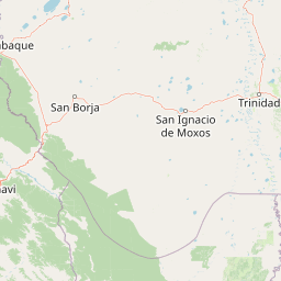
Map view of Rhukanrhuka Municipal Protected Area

Use this park location map to pinpoint Rhukanrhuka Municipal Protected Area in Bolivia, understand its exact geographic position, and read its mapped placement within the surrounding landscape more clearly.

Pigeon | © OpenStreetMap contributors

Location context for Rhukanrhuka Municipal Protected Area

Beni Department

Visualizing the white water rivers, tectonic lakes, and transitional savanna habitats

Área Protegida Municipal Rhukanrhuka Landscape Photos and Scenery

Explore detailed photographs of Área Protegida Municipal Rhukanrhuka to observe the unique transitional terrain where Andean foothills meet the vast Llanos de Moxos floodplain. Examining these protected area images provides a clear visual understanding of the complex gallery forests, riverine corridors, and wetland habitats defining the region.

An anaconda with dark oval spots on its scales is coiled on a patch of grass and dirt.

A close-up view of a large, vibrant yellow cacao pod growing directly from the trunk and branches of a cacao tree in a forest setting.

Park atlas

Compare surrounding protected landscapes and transitional Amazonian ecosystems

Parks Near Área Protegida Municipal Rhukanrhuka and Connected Regional Protected Areas

Browsing other parks near Área Protegida Municipal Rhukanrhuka reveals how lowland Amazonian forests connect with broader regional conservation networks. Examining adjacent protected areas provides deeper insight into northern Bolivian river basins and transitional wetland habitats.
A horizontal watercolor painting of a river landscape with lush green vegetation in the foreground and soft, hazy hills in the background.
Protected areaBeni
About 72 km away#1 closest

East

Área protegida municipal Pampas del río Yacuma: Protected Area and Wetland Geography

A large-scale municipal sanctuary in the Bolivian Amazon

This significant protected area encompasses the expansive floodable savannas of the Llanos de Moxos. Its mosaic of forest islands and riverine wetlands provides a critical refuge for endemic species and iconic Amazonian wildlife. The geography is shaped by the Yacuma River, creating a seasonal environment that bridges indigenous heritage with modern conservation land management.

Area
6,164.53 km²
Established
2007
Visitors
16K annual
Relief
Lowland
National parkLa Paz Department
About 76 km away#2 closest

Northwest

Madidi National Park: National Park Protected Landscape and Geographic Atlas Entry

Explore mapped boundaries and regional context in La Paz Department.

Madidi National Park is a designated national park situated in Bolivia's La Paz Department. This detail entry offers a focused perspective on its protected landscape, its specific geographic setting, and its role within the larger atlas of natural areas. Understand the park's mapped boundaries and its contribution to the regional geography, providing a foundation for structured discovery of Bolivia's protected lands.

Area
18,957.5 km²
Established
1995
IUCN
II
Relief
Mixed relief
A pale, soft-toned watercolor illustration of a calm river landscape with rolling hills in the background and sparse trees along the banks.
Biosphere reserveBolivia
About 93 km away#3 closest

South

Reserva de la Biosfera y Tierra Comunitaria de Origen Pilón Lajas Protected Landscape Atlas

Mapping the Andean Amazonian transition in northern Bolivia

Spanning from high mountain ridges to the river plains of the Beni, this protected area features a unique vertical gradient of ecosystems including cloud forests and terra firme. It represents a significant model for indigenous co governance and biodiversity protection within the broader Andean and Amazonian geographic context.

Area
4,000 km²
Established
1992
Relief
Mountain
Climate
Tropical
A horizontal watercolor painting depicting a soft-focus landscape with green hills, a winding river, and reddish marshy foreground vegetation.
Biosphere reserveBolivia
About 126 km away#4 closest

East

Reserva de Biosfera Estación Biológica del Beni: Protected Landscape and Geographic Atlas

Examining the Amazonian lowland mosaic of northern Bolivia

The Reserva de Biosfera Estación Biológica del Beni sits within the wide alluvial plains of the Llanos de Moxos. This protected area features a unique, flat terrain where tropical forest fragments persist as islands amidst seasonally flooded palm savannas, cyperaceous marshes, and shallow lagoons, providing a critical study area for Amazonian biodiversity.

Area
1,350 km²
Established
1982
Relief
Lowland
Climate
Tropical
Nature reserveBeni Department
About 141 km away#5 closest

East

Reserva natural Barba Azul: A Protected Savanna Sanctuary in the Beni Department

Mapping flooded grasslands and gallery forest ecosystems

Reserva natural Barba Azul stands as a key protected area within the Bolivian Amazon lowlands. This nature reserve, centered in the Beni Department, preserves a rare mosaic of motacú palm forests and seasonal wetlands that serve as a critical stronghold for endangered parrots and migratory shorebirds within the larger Llanos de Moxos region.

Area
110 km²
Established
2008
Relief
Lowland
Climate
Tropical
Regional parkBeni
About 159 km away#6 closest

Southeast

Parque regional Yacuma: Geographic Overview and Protected Landscape Mapping

Riparian ecosystems and flooded savanna terrain in Beni, Bolivia

Explore the expansive floodplain mosaic of Parque regional Yacuma, where the Yacuma and Beni river systems create a vital refuge for lowland wildlife. The park offers an essential view into the seasonal transitions of northern Bolivia, bridging pre-Andean forests and inundated savanna plains that define this significant regional conservation corridor.

Area
1,200 km²
Established
1990
Water
Major water bodies
National parkPeru
About 176 km away#7 closest

Northwest

Bahuaja-Sonene National Park: A Major Amazon Frontier National Park in Peru's Geography

Explore its mapped protected landscape and diverse terrain.

Bahuaja-Sonene National Park is an extensive national park situated on the Amazon frontier in southern Peru, encompassing a crucial transition zone between lowland rainforest and higher-elevation forest ecosystems. Its diverse topography, from river valleys to mountainous slopes, creates varied natural landscapes. The park's protected boundaries are integral to the regional conservation strategy, offering a unique lens through which to study the mapped geography and ecological significance of this vast Amazonian protected area.

Area
10,914.2 km²
Established
1996
IUCN
II
Relief
Mixed relief
A panoramic watercolor illustration of a mountain landscape with rolling green hills, pink distant peaks, and small green bushes in the foreground.
Protected areaBolivia
About 185 km away#8 closest

Southwest

Área Natural de Manejo Integrado Apolobamba: Protected Landscape Geography and Andean Terrain

High-altitude glacial geography and Andean-Amazonian transition zones

Located in the department of La Paz, this protected area features a rugged landscape defined by tectonic uplift and Quaternary glaciation. It safeguards critical high-Andean habitats, including peatlands and Polylepis woodlands, while providing a essential refuge for vicuña populations within its steeply dissected mountain topography.

Area
4,837.43 km²
Established
1972
Relief
Mountain
Climate
Alpine

Common questions about visiting, size, designation, and location context for Rhukanrhuka Municipal Protected Area

Rhukanrhuka Municipal Protected Area FAQs for park facts, access, geography, and protected area context

Find quick answers about Rhukanrhuka Municipal Protected Area, including protected-area facts, park geography, trail and visitor context, and how the park fits into its surrounding country and regional landscape.
MoriAtlas Explorer

Continue Your Protected Areas Search Across the Global Atlas

Deepen your exploration by continuing the structured search for national parks and protected areas worldwide. Utilize the comprehensive filtering capabilities to compare different conservation landscapes and refine your understanding of global park geography. Discover more about the distribution and characteristics of protected natural areas.

Global natural geography