
Mori Atlas logo
Protected areaÁrea protegida municipal Pampas del río Yacuma

Discover the expansive floodable savannas, gallery forests, and seasonal river networks of this Amazonian sanctuary.

Área protegida municipal Pampas del río Yacuma: Mapping the Llanos de Moxos Wetlands

(Área Protegida Municipal Pampas del río Yacuma)

Área protegida municipal Pampas del río Yacuma represents a massive municipal conservation landscape within the Beni Department of Bolivia. This protected area preserves a dynamic mosaic of floodable savannas, isolated forest islands, and riverine gallery forests that define the heart of the Llanos de Moxos ecoregion. The Yacuma River system serves as the primary hydrological driver, creating a seasonal landscape that supports significant biodiversity and endemic species within the Amazon basin.

wetlandsfloodable savannasLlanos de MoxosAmazon basinBoliviaBeni Department
A stylized digital illustration of a waterfall flowing down between two cliffs into a river, surrounded by a lush forest under a soft-colored sky.

Área protegida municipal Pampas del río Yacuma

Protected area

Park overview

Structured park overview, official facts, and landscape profile for Pampas del Yacuma Municipal Protected Area

Pampas del Yacuma Municipal Protected Area park facts, protected area profile, and essential visitor context

Review the core facts for Pampas del Yacuma Municipal Protected Area, including designation, size, terrain, visitor scale, habitats, and operating context in one park-focused overview.

About Pampas del Yacuma Municipal Protected Area

Pampas del Yacuma occupies a vast stretch of the Bolivian lowlands in the northern Beni Department, within the Llanos de Moxos, one of South America's most ecologically distinctive wetland landscapes. The protected area was created in 2007 through a municipal resolution, reflecting a strong local commitment to safeguarding the region's floodable ecosystems and ensuring that economic activities such as cattle ranching remain compatible with conservation.

The landscape is shaped by the annual pulse of the Yacuma River and its tributaries, which transform huge areas of savanna into shallow lagoons during the wet season and leave behind concentrated wildlife congregations as waters recede. This seasonal rhythm is central to the experience of the area and to its ecological function, drawing wildlife from across the region into a dynamic mosaic of flooded grasslands, forest islands, and gallery forests along the rivers.

Within the protected area's boundaries lie the town of Santa Rosa de Yacuma, several rural communities, and around one hundred seventy cattle estancias, illustrating how traditional land use has been woven into the reserve's management framework. The area also carries deep cultural significance, as the wider Llanos de Moxos region is associated with the ancestral Arawak civilization and remains home to Tacana indigenous communities whose presence predates modern borders.

At a global scale, Pampas del Yacuma stands out for its sheer size among municipal protected areas. It demonstrates how a single Bolivian municipality has taken responsibility for conserving one of the most ecologically important wetland complexes in the Amazon basin, while still supporting a working rural landscape shaped by cattle ranching and small communities.

Quick facts and research context for Pampas del Yacuma Municipal Protected Area

Pampas del Yacuma is a municipal-level protected area located in the Beni Department of Bolivia within the Llanos de Moxos ecoregion. It lies in the lowlands at a relatively low altitude, with a tropical climate marked by warm temperatures year-round. The reserve was established in 2007 by the municipal government of Santa Rosa de Yacuma under Resolution N°15/2007, with support from conservation organizations and USAID.

Although managed at the municipal level, the area is one of the largest municipal protected areas in the world, extending across a vast expanse of floodable savannas and wetlands. It contains rural communities and numerous cattle estancias, showing the integration of conservation goals with the traditional ranching culture of the Beni region.

Protection and recognition

Explore documented terrestrial conservation scope and official designation records.

Área protegida municipal Pampas del río Yacuma Protection Status and Recognition

Terrestrial protection status and management frameworks for Área protegida municipal Pampas del río Yacuma appear alongside verified administrative records. Conservation data compiles official designations and international recognition sources to support structured geographic research.

Protection details

Protection scope
Terrestrial
Transboundary protection
No
Park context

Deeper park guide and search-rich context for Pampas del Yacuma Municipal Protected Area

Pampas del Yacuma Municipal Protected Area history, landscape, wildlife, and travel context

Explore Pampas del Yacuma Municipal Protected Area through its history, landscape character, ecosystems, wildlife, conservation priorities, cultural context, and seasonal travel timing in a structured park guide built for atlas discovery and search intent.

Why Pampas del Yacuma Municipal Protected Area stands out

The park is best known for its enormous expanse of floodable savannas and wetlands in the heart of the Llanos de Moxos, which support an unusually rich assemblage of Amazonian wildlife. Among its most iconic inhabitants are the jaguar, the black caiman, the maned wolf (locally called borochi), the marsh deer, the giant armadillo, the harpy eagle, and the pink river dolphin, all of which thrive in the mosaic of grasslands, gallery forests, and seasonal lagoons. The reserve is also notable as a refuge for several species endemic to Bolivia, including two little-known titi monkeys and the blue-throated macaw. Its standing as one of the largest municipal protected areas anywhere reinforces its reputation as a benchmark case for locally driven conservation at a very large scale.
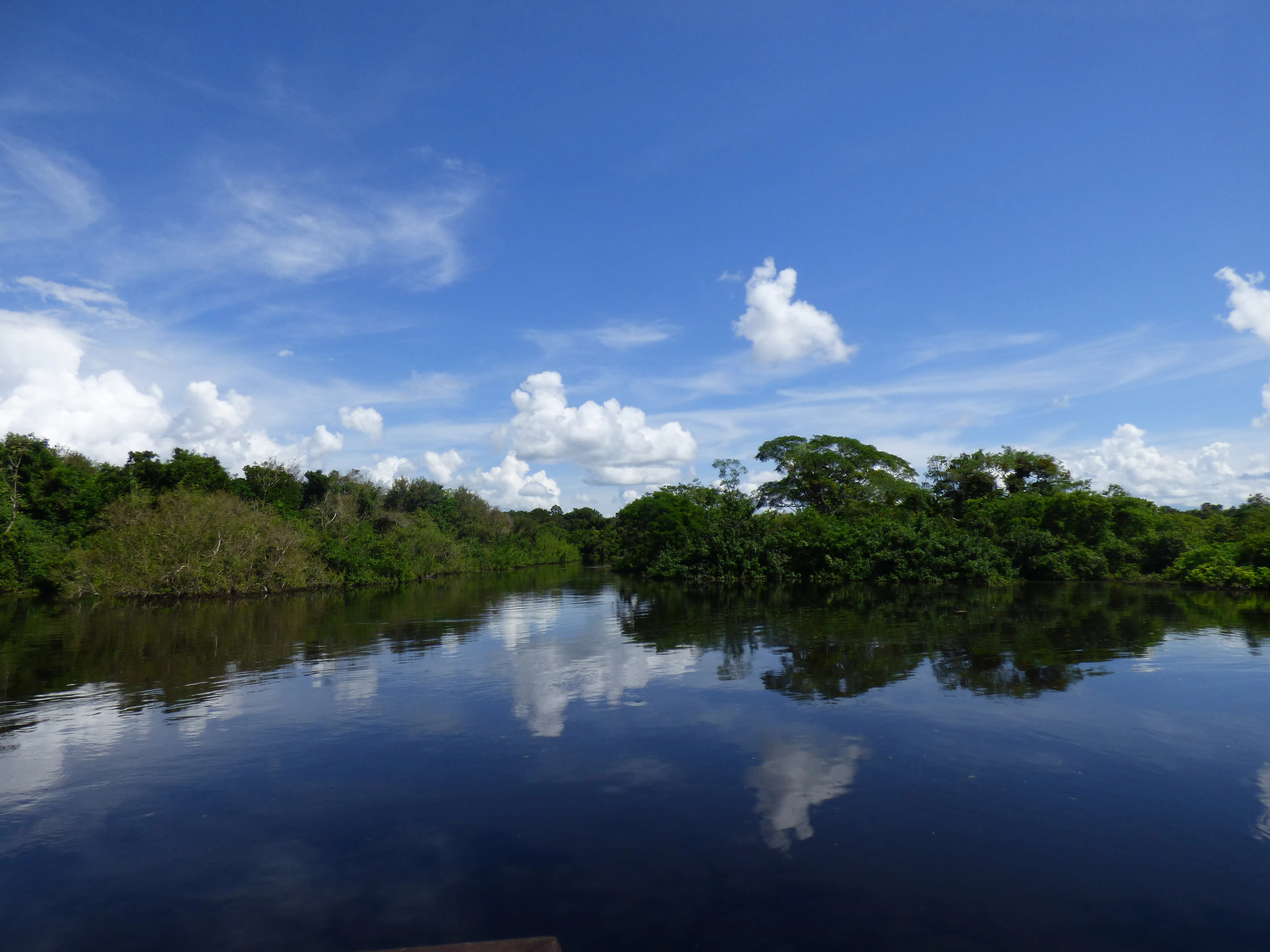
A wide view of a calm, dark river reflecting a bright blue sky with white clouds, bordered by dense tropical forest.
A calm, reflective view of the Yacuma River as it winds through the Amazonian floodplain.

Pampas del Yacuma Municipal Protected Area history and protected-area timeline

The modern protected area was formally established on July 8, 2007, when the municipal government of Santa Rosa de Yacuma issued Resolution N°15/2007. The decision to create the reserve was shaped by collaboration between the municipality, Bolivian conservation institutions, and the United States Agency for International Development (USAID). Their shared aim was to protect the floodable savannas, wetlands, and associated wildlife of the Beni lowlands in the face of expanding land use pressures.

Since its creation, the reserve has become one of the most prominent locally managed conservation areas in Bolivia, demonstrating that municipal governments can play a leading role in protecting large wetland landscapes. Its establishment also reflects a broader effort across the Llanos de Moxos to formalize protection for ecosystems that have historically supported both indigenous communities and the region's ranching economy.

Pampas del Yacuma Municipal Protected Area landscape and geographic character

The landscape of Pampas del Yacuma is defined by the flat, low-lying terrain of the Llanos de Moxos. Across its vast surface, open floodable savannas dominate, interspersed with raised forest islands, gallery forests along the rivers, and countless seasonal lagoons and channels. The altitude is relatively modest and uniform, producing expansive horizons where water, grass, and scattered woodland blend into a single, dynamic ecosystem.

The Yacuma River and its network of tributaries are the principal sculptors of this environment. During the wet season, rising waters convert large parts of the savanna into a patchwork of flooded grasslands and shallow pools. As the dry season advances, water levels fall and concentrate wildlife around remaining lagoons and river courses, creating some of the most productive wildlife-viewing conditions in the Bolivian Amazon.

Pampas del Yacuma Municipal Protected Area ecosystems, habitats, and plant life

Ecologically, the protected area sits within the Llanos de Moxos, a region renowned for its rich mosaic of wetlands, savannas, and tropical forests. The combination of permanent and seasonal water bodies with forest islands produces a landscape of extraordinary habitat diversity, supporting species that depend on aquatic environments, open grasslands, and closed-canopy forest within the same area.

The vegetation pattern is equally varied, ranging from open seasonally flooded grasslands and palm-dominated formations to patches of higher, more stable forest and riparian corridors of gallery trees. This structure creates a year-round varied ecosystem, where different habitats shift in importance with the rise and fall of water levels, supporting a wide array of wildlife and ecological processes throughout the annual cycle.

Pampas del Yacuma Municipal Protected Area wildlife and species highlights

Pampas del Yacuma harbors a remarkable cross-section of Amazonian and wetland fauna, including many threatened species that have become symbols of the reserve. Among the most notable are the jaguar, the black caiman, the giant armadillo, and the marsh deer, which depend on the mixture of forest islands and flooded grasslands. Large mammals such as the maned wolf (borochi) and the giant anteater also roam the area.

The reserve is similarly important for raptors and other birds, with the harpy eagle being a flagship species of Beni lowland forests. Wetland and grassland specialists such as the cock-tailed tyrant (yetapá) and the rhea (ñandú) are also present, reflecting the diversity of open-country and marsh habitats.

Aquatic wildlife is equally significant: the pink river dolphin inhabits the Yacuma River system, while river turtles contribute to the freshwater biodiversity of the region. Smaller, less well-known species also find refuge here, including the bush dog and several species endemic to Bolivia, such as two titi monkeys, the Beni titi and Ollala's titi monkey, and the striking blue-throated macaw. Together, these animals make Pampas del Yacuma one of the most wildlife-rich protected areas in the country.

Pampas del Yacuma Municipal Protected Area conservation status and protection priorities

The protected area was created specifically to safeguard the wetland and floodable savanna ecosystems of the Beni Department, which are among the most ecologically valuable yet most vulnerable habitats in the Bolivian Amazon. Annual flooding and seasonal drying sustain an extraordinary concentration of biodiversity, but also make the landscape sensitive to changes in land use, hydrology, and climate.

By formalizing protection at the municipal level, the reserve has provided a long-term framework for managing these ecosystems alongside the existing cattle ranching and rural community activities that define much of the area. Its role in sustaining threatened species such as the jaguar, black caiman, harpy eagle, and marsh deer gives Pampas del Yacuma considerable conservation importance at both national and regional scales.

Pampas del Yacuma Municipal Protected Area cultural meaning and human context

The broader Llanos de Moxos region is considered the ancestral home of the pre-Hispanic Arawak civilization and remains home to Tacana indigenous communities whose presence in the area predates contemporary national boundaries. Their long-standing relationship with the wetlands, rivers, and forests of the Beni lowlands is an integral part of the cultural landscape of Pampas del Yacuma.

In addition to its indigenous heritage, the area carries strong rural and ranching traditions. The presence of numerous cattle estancias and established farming communities inside the protected area reflects the deep historical connection between the people of the Beni and the management of the floodable savannas that surround them.

Top sights and standout views in Pampas del Yacuma Municipal Protected Area

Pampas del Yacuma stands out for the sheer scale of its protected wetlands, the exceptional density of Amazonian wildlife it sustains, and its pioneering status as one of the largest municipal protected areas in the world. The reserve's combination of floodable savannas, forest islands, and gallery forests creates a setting where jaguar, black caiman, giant otter, and pink river dolphin can all be found within the same landscape. Its role as a refuge for endemic Bolivian species, including two titi monkeys and the blue-throated macaw, adds an important dimension to its conservation value.

Best time to visit Pampas del Yacuma Municipal Protected Area

The character of a visit to Pampas del Yacuma is strongly shaped by the seasonal rhythm of the Llanos de Moxos. During the dry season, falling water levels concentrate wildlife around remaining lagoons and river channels, often making it easier to observe concentrations of mammals, birds, and caimans. The wet season, in contrast, transforms large parts of the savanna into shallow flooded plains, offering a very different but equally captivating perspective on the scale and dynamics of the wetland ecosystem. Warm temperatures are the norm year-round.

Monthly climate preview

Long term temperature and precipitation rhythm across representative lowland coordinates

Área protegida municipal Pampas del río Yacuma Climate Normals and Weather by Month

Representative coordinate records show sustained monthly warmth alongside pronounced wet and dry seasonal rainfall shifts across the terrain. Reviewing full twelve month climatology profiles provides deeper insight into measured temperature variations and precipitation averages.
Annual mean26 °C
24 °C29 °C
Jan26°
Feb26°
Mar26°
Apr26°
May25°
Jun24°
Jul24°
Aug26°
Sep28°
Oct29°
Nov28°
Dec27°
Warmest month
October

28.7 °C

Coolest month
June

24.1 °C

Wettest month
February

9.3 mm/day

Driest month
August

1.5 mm/day

Park location guide

Geography guide, regional context, and park location map for Pampas del Yacuma Municipal Protected Area

Pampas del Yacuma Municipal Protected Area park geography, regions, and map view in Bolivia

Understand where Pampas del Yacuma Municipal Protected Area sits in Bolivia through a broader geographic reading of the surrounding landscape, nearby location context, and its mapped position within the national park landscape.

How Pampas del Yacuma Municipal Protected Area fits into Bolivia

Bolivia, officially the Plurinational State of Bolivia, is a landlocked country in central South America. It features diverse geography including the Andean mountain range, Amazonian plains, Gran Chaco, and the Pantanal wetland. The country has a population of approximately 11.4 million and is administratively divided into nine departments, with La Paz as the seat of government and Sucre as the constitutional capital.

Wider geography shaping Pampas del Yacuma Municipal Protected Area in Bolivia

Bolivia is located in central South America, bordered by Brazil to the north and east, Paraguay to the southeast, Argentina to the south, Chile to the southwest, and Peru to the west. The country is divided between a western Andean region and tropical lowlands to the east and north. It includes the Amazonian plain, Gran Chaco, temperate valleys, the high-altitude Altiplano plateau, and part of the Pantanal wetland along its eastern border.

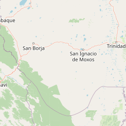
Map view of Pampas del Yacuma Municipal Protected Area

Use this park location map to pinpoint Pampas del Yacuma Municipal Protected Area in Bolivia, understand its exact geographic position, and read its mapped placement within the surrounding landscape more clearly.

Pigeon | © OpenStreetMap contributors

Location context for Pampas del Yacuma Municipal Protected Area

Beni

Visualizing the floodable savannas, wetlands, and wildlife habitats of northern Bolivia

Área protegida municipal Pampas del río Yacuma Landscape Photos and Scenery

Visual records capture the expansive floodable savannas, winding river channels, and gallery forests defining the terrain of Área protegida municipal Pampas del río Yacuma. Studying these field photographs provides a deeper understanding of the seasonal wetland habitats and lowland Amazonian ecosystems protected across the region.

A wide view of a calm, dark river reflecting a bright blue sky with white clouds, bordered by dense tropical forest.

A long-necked bird swimming in murky brown river water with a small fish in its beak.

Park atlas

Compare surrounding regional geography and connected Amazon basin conservation landscapes.

Parks Near Área protegida municipal Pampas del río Yacuma and Related Protected Areas

Browse other protected areas and wetland reserves located near Área protegida municipal Pampas del río Yacuma in northern Bolivia. Continuing into adjacent park records provides broader context on lowland floodable savannas, seasonal river networks, and regional wildlife habitats.
Nature reserveBeni Department
About 68 km away#1 closest

East

Reserva natural Barba Azul: A Protected Savanna Sanctuary in the Beni Department

Mapping flooded grasslands and gallery forest ecosystems

Reserva natural Barba Azul stands as a key protected area within the Bolivian Amazon lowlands. This nature reserve, centered in the Beni Department, preserves a rare mosaic of motacú palm forests and seasonal wetlands that serve as a critical stronghold for endangered parrots and migratory shorebirds within the larger Llanos de Moxos region.

Area
110 km²
Established
2008
Relief
Lowland
Climate
Tropical
Protected areaBeni Department
About 72 km away#2 closest

West

Área Protegida Municipal Rhukanrhuka: Mapping Amazonian Biodiversity and Riverine Terrain

A transitional protected landscape in the Beni Department of Bolivia

Spanning a vast transition from Andean slopes to the Llanos de Moxos floodplain, Área Protegida Municipal Rhukanrhuka protects a dynamic mosaic of white-water rivers, gallery forests, and tectonic lakes. This significant municipal reserve serves as a refuge for threatened species and sustains indigenous Maropa communities within its borders, anchoring an essential conservation corridor in the northern Amazon.

Area
8,594.51 km²
Established
2019
Relief
Lowland
Climate
Tropical
A horizontal watercolor painting depicting a soft-focus landscape with green hills, a winding river, and reddish marshy foreground vegetation.
Biosphere reserveBolivia
About 74 km away#3 closest

Southeast

Reserva de Biosfera Estación Biológica del Beni: Protected Landscape and Geographic Atlas

Examining the Amazonian lowland mosaic of northern Bolivia

The Reserva de Biosfera Estación Biológica del Beni sits within the wide alluvial plains of the Llanos de Moxos. This protected area features a unique, flat terrain where tropical forest fragments persist as islands amidst seasonally flooded palm savannas, cyperaceous marshes, and shallow lagoons, providing a critical study area for Amazonian biodiversity.

Area
1,350 km²
Established
1982
Relief
Lowland
Climate
Tropical
Regional parkBeni
About 118 km away#4 closest

Southeast

Parque regional Yacuma: Geographic Overview and Protected Landscape Mapping

Riparian ecosystems and flooded savanna terrain in Beni, Bolivia

Explore the expansive floodplain mosaic of Parque regional Yacuma, where the Yacuma and Beni river systems create a vital refuge for lowland wildlife. The park offers an essential view into the seasonal transitions of northern Bolivia, bridging pre-Andean forests and inundated savanna plains that define this significant regional conservation corridor.

Area
1,200 km²
Established
1990
Water
Major water bodies
A pale, soft-toned watercolor illustration of a calm river landscape with rolling hills in the background and sparse trees along the banks.
Biosphere reserveBolivia
About 128 km away#5 closest

Southwest

Reserva de la Biosfera y Tierra Comunitaria de Origen Pilón Lajas Protected Landscape Atlas

Mapping the Andean Amazonian transition in northern Bolivia

Spanning from high mountain ridges to the river plains of the Beni, this protected area features a unique vertical gradient of ecosystems including cloud forests and terra firme. It represents a significant model for indigenous co governance and biodiversity protection within the broader Andean and Amazonian geographic context.

Area
4,000 km²
Established
1992
Relief
Mountain
Climate
Tropical
National parkLa Paz Department
About 144 km away#6 closest

West

Madidi National Park: National Park Protected Landscape and Geographic Atlas Entry

Explore mapped boundaries and regional context in La Paz Department.

Madidi National Park is a designated national park situated in Bolivia's La Paz Department. This detail entry offers a focused perspective on its protected landscape, its specific geographic setting, and its role within the larger atlas of natural areas. Understand the park's mapped boundaries and its contribution to the regional geography, providing a foundation for structured discovery of Bolivia's protected lands.

Area
18,957.5 km²
Established
1995
IUCN
II
Relief
Mixed relief
A watercolor painting showing a soft, atmospheric landscape with a winding river, green banks, trees, and distant low hills against a white background.
Protected areaBeni Department
About 199 km away#7 closest

Southeast

Área Protegida Municipal Ibare-Mamoré: Geography and Protected Area Context

Riverine landscapes and wetlands in Bolivia's Beni Department

The Área Protegida Municipal Ibare-Mamoré encompasses a diverse range of ecosystems, from upland forests to open grasslands and shifting river channels. As a key conservation unit near the city of Trinidad, this area highlights the ecological importance of the Llanos de Moxos region through its interconnected aquatic and terrestrial habitats.

Area
256.08 km²
Established
2011
Relief
Lowland
Climate
Tropical
National parkBolivia
About 239 km away#8 closest

South

Isiboro Sécure National Park and Indigenous Territory: Bolivian Protected National Park Atlas

Mapped protected boundaries and regional landscape context.

Investigate Isiboro Sécure National Park and Indigenous Territory as a key protected national park within Bolivia's expansive geography. This resource offers detailed views of its mapped natural landscape and its regional significance as a protected area. Understand the park's geographic attributes and its contribution to the country's conservation atlas through structured map-based exploration.

Area
13,721.8 km²
Established
1965
IUCN
II
Relief
Mixed relief

Common questions about visiting, size, designation, and location context for Pampas del Yacuma Municipal Protected Area

Pampas del Yacuma Municipal Protected Area FAQs for park facts, access, geography, and protected area context

Find quick answers about Pampas del Yacuma Municipal Protected Area, including protected-area facts, park geography, trail and visitor context, and how the park fits into its surrounding country and regional landscape.
MoriAtlas Explorer

Continue Your Protected Areas Search Across the Global Atlas

Deepen your exploration by continuing the structured search for national parks and protected areas worldwide. Utilize the comprehensive filtering capabilities to compare different conservation landscapes and refine your understanding of global park geography. Discover more about the distribution and characteristics of protected natural areas.

Global natural geography