Mori Atlas logo
Protected landscapeÁrea Natural de Manejo Integrado Humedales del Norte

Mapped hydrological systems and seasonal wetland geography in northern Santa Cruz, Bolivia.

Área Natural de Manejo Integrado Humedales del Norte: Amazonian Floodplain and Protected Landscape

The Área Natural de Manejo Integrado Humedales del Norte comprises a significant Amazonian floodplain system spanning the Ichilo, Guarayos, and Obispo Santistevan provinces. This expansive protected landscape regulates essential regional hydrological cycles through a complex network of seasonal wetlands, flooded forests, and slow-moving rivers. The protected area serves as a critical buffer for climate and wind patterns across the northern lowlands of the Santa Cruz department.

Amazonian floodplainwetlandsprotected areaRamsar candidateSanta Cruz departmentflooded forest

Área Natural de Manejo Integrado Humedales del Norte

Protected landscape

Park overview

Structured park overview, official facts, and landscape profile for Área Natural de Manejo Integrado Humedales del Norte

Área Natural de Manejo Integrado Humedales del Norte park facts, protected area profile, and essential visitor context

Review the core facts for Área Natural de Manejo Integrado Humedales del Norte, including designation, size, terrain, visitor scale, habitats, and operating context in one park-focused overview.

About Área Natural de Manejo Integrado Humedales del Norte

Área Natural de Manejo Integrado Humedales del Norte stands as one of the most expansive wetland reserves in the Bolivian lowlands, occupying a strategic position where the Amazonian ecosystems of northern Santa Cruz converge across three provinces. Its sheer size, on the order of half a million hectares, reflects an effort to conserve a functioning landscape at a regional scale rather than a small ecological fragment. The reserve captures a mosaic of flooded forest, permanent and seasonal wetlands, river channels, and forested islands typical of southwestern Amazonia.

The value of the area lies in its hydrology. The wetlands store and release water across the seasonal cycle, moderating temperatures, buffering winds, and feeding streams and rivers that connect to broader Amazonian drainage networks. This makes the reserve significant not only for biodiversity but also for the wider environmental stability of northern Bolivia. The departmental government of Santa Cruz designated the area through Law 98 in 2012 specifically to safeguard these regulating functions, recognizing that the loss of wetlands would have consequences far beyond the immediate boundary of the reserve.

For conservation in Bolivia, Humedales del Norte is also notable as a candidate for international recognition. Efforts since 2017 have focused on attaining Ramsar Site status, which would place the reserve alongside Bolivia's extensive network of internationally recognized wetlands. The country's leading position in total Ramsar-designated area underscores the broader importance of the country's wetland heritage, and the inclusion of this reserve would further consolidate that standing in the context of Amazonian floodplain conservation.

Quick facts and research context for Área Natural de Manejo Integrado Humedales del Norte

Área Natural de Manejo Integrado Humedales del Norte is a large protected area in the Bolivian department of Santa Cruz, situated in the northern lowlands of the country. It crosses three provinces: Ichilo, Guarayos, and Obispo Santistevan.

The reserve lies within the Amazonian flooded forest ecoregion and consists predominantly of wetlands, river corridors, and seasonally inundated tropical forest. It was created in 2012 under Santa Cruz Departmental Law 98, with an extent of about 490,051 hectares.

Its principal town of reference is Ascensión de Guarayos. Administrative responsibility rests with the Gobierno Autónomo Departamental de Santa Cruz. Efforts to obtain Ramsar Site status have been underway since 2017.

Protection and recognition

Documented terrestrial protection scope and official designation metrics

Área Natural de Manejo Integrado Humedales del Norte Protection Status

Terrestrial protection status records establish the formal conservation framework and management scope established for Área Natural de Manejo Integrado Humedales del Norte. Documented administrative criteria outline the protected area designation details without referencing unverified international programs or external registry IDs.

Protection details

Protection scope
Terrestrial
Transboundary protection
No
Park context

Deeper park guide and search-rich context for Área Natural de Manejo Integrado Humedales del Norte

Área Natural de Manejo Integrado Humedales del Norte history, landscape, wildlife, and travel context

Explore Área Natural de Manejo Integrado Humedales del Norte through its history, landscape character, ecosystems, wildlife, conservation priorities, cultural context, and seasonal travel timing in a structured park guide built for atlas discovery and search intent.

Why Área Natural de Manejo Integrado Humedales del Norte stands out

The reserve is best known for protecting an extensive tract of Amazonian floodplain wetlands in northern Santa Cruz, including river systems that host the Amazon river dolphin, locally known as the bufeo. Its vast seasonally flooded forests and slow-moving rivers are central to the regional hydrological cycle and to climate regulation across the surrounding lowlands.

Área Natural de Manejo Integrado Humedales del Norte history and protected-area timeline

The reserve has a relatively short formal history, having been created in 2012 through Santa Cruz Departmental Law 98. The legislation established the Área Natural de Manejo Integrado Humedales del Norte as a departmental protected area, with an initial extent of approximately 490,051 hectares crossing the provinces of Ichilo, Guarayos, and Obispo Santistevan.

Its creation reflected growing awareness of the ecological importance of the floodplain wetlands in northern Santa Cruz and a departmental effort to safeguard hydrological and climatic functions that support both ecosystems and human communities in the lowlands.

From 2017 onward, the Gobierno Autónomo Departamental de Santa Cruz began pursuing international recognition of the reserve as a Ramsar Site. Although the formal inscription process is complex and involves coordination with the national government, the initiative signals a shift toward treating the area as a wetland of hemispheric, not just departmental, importance.

Área Natural de Manejo Integrado Humedales del Norte landscape and geographic character

The landscape of Humedales del Norte is defined by the dynamics of Amazonian floodplains. The terrain is largely flat to gently undulating, shaped by the rise and fall of rivers that inundate vast stretches of forest during the wet season. Slow-moving waterways, permanent and seasonal lagoons, and associated flood-tolerant forests form the structural backbone of the area.

Seasonal water level changes are one of the defining features of the landscape. During high-water periods, large forest tracts are submerged, creating complex aquatic and semi-aquatic environments. In drier months, the same terrain re-emerges as a mosaic of saturated soils, isolated pools, and channels that retain water for months. This alternation produces a shifting landscape that is neither purely terrestrial nor purely aquatic but a continually responsive floodplain system.

Surrounding the wetland core are forested transitions that gradually connect to drier terra firme forest and to agricultural landscapes that border the protected area. This gradient between flooded interior forest, river-edge vegetation, and upland forest underscores the importance of protecting the reserve at the scale necessary to maintain the natural hydrological pulse.

Área Natural de Manejo Integrado Humedales del Norte ecosystems, habitats, and plant life

Ecologically, the reserve belongs to the Amazonian floodplain ecoregion, a system characterized by high biological productivity driven by nutrient-rich waters and seasonal dynamics. Its habitats include permanently flooded forests, seasonally inundated forests, river channels, oxbow lakes, and emergent wetland vegetation, all interlinked within the larger Amazonian drainage.

The combination of permanent water and seasonal fluctuation creates a rich suite of microhabitats. Shaded forest streams, open-water lagoons, flooded grasslands, and saturated palm swamps each support distinct ecological communities. The reserve's continuity across such a large area is significant for ecological processes that depend on landscape-scale habitat connectivity, including fish movements, waterbird dispersal, and the breeding cycles of many floodplain species.

The wetland mosaic is also important for nutrient cycling. Leaf litter, sediment, and organic material carried by floodwaters contribute to the productivity of aquatic and riparian food webs, while forest cover stabilizes banks, filters water, and maintains the dark, tannin-rich conditions of forest streams. These processes together sustain a functioning Amazonian wetland system within the broader Bolivian Amazon.

Área Natural de Manejo Integrado Humedales del Norte wildlife and species highlights

The reserve's most emblematic wildlife presence is the Amazon river dolphin, locally known as the bufeo, which inhabits the rivers of the area. Its continued presence is widely regarded as an indicator of healthy river systems and is a point of regional pride and ecological interest.

The flooded forests, rivers, and lagoons also support a wide range of aquatic and semi-aquatic species typical of southwestern Amazonia, including various fish groups that migrate or reproduce in response to the flood pulse. The mosaic of habitats makes the area conducive to waterbirds and to forest species that tolerate seasonal flooding, both of which benefit from the connectivity that the reserve maintains.

Because the area is large and largely continuous with surrounding forested landscapes, it offers refuge for wildlife sensitive to human disturbance. The presence of long river corridors, intact flooded forest, and a relatively intact seasonal hydrology provides conditions that allow a more complete expression of Amazonian fauna than would be possible in fragmented or degraded landscapes.

Área Natural de Manejo Integrado Humedales del Norte conservation status and protection priorities

Conservation in Humedales del Norte emphasizes the protection of large-scale ecological and hydrological processes rather than single-species preservation. The 2012 creation of the area as an Área Natural de Manejo Integrado reflects this integrated approach, recognizing wetlands as systems that simultaneously provide habitat, regulate climate, and sustain water resources.

The reserve is positioned as a candidate Ramsar Site, an international designation managed under the Convention on Wetlands. Inscription would place it within a global framework for wetland conservation and bring additional standards of monitoring and management. Bolivia currently leads the world in cumulative Ramsar-designated area, and the addition of Humedales del Norte would further consolidate this status.

Like other forested protected areas in Bolivia, the reserve faces pressures from illegal settlement and indiscriminate logging, which are ongoing concerns for conservation management. Effective protection depends on maintaining the integrity of the floodplain dynamics and the surrounding forest, both of which are vulnerable to fragmentation and to changes in land use along the borders of the protected area.

Top sights and standout views in Área Natural de Manejo Integrado Humedales del Norte

Humedales del Norte is distinguished by the sheer scale of its floodplain wetlands, which collectively regulate climate, temperature, wind patterns, and the hydrological cycle across a major portion of northern Santa Cruz. Its 2012 founding marked a deliberate effort to protect these regulating functions at a meaningful landscape scale.

The presence of the bufeo, the Amazon river dolphin, lends the reserve a powerful wildlife symbol rooted in the regional Amazonian identity. Coupled with the ongoing pursuit of Ramsar recognition, the reserve stands out as a natural area where ecological function, hydrological importance, and conservation ambition converge.

Best time to visit Área Natural de Manejo Integrado Humedales del Norte

The experience of the area varies strongly with the seasonal flood cycle of the Amazonian lowlands. During high-water months, large parts of the forest flood, river channels expand, and traveling through the interior requires boats; wildlife tends to concentrate along waterways and in tree canopies. During lower-water months, access along rivers is easier in some reaches, exposed beaches and bars appear, and forest wildlife becomes more accessible along trails that cut through drier terrain.

For water-associated wildlife, including river dolphins and waterbirds, periods of transition between flood and low water can be particularly dynamic. Those interested in flooded forest landscapes generally favor the high-water season for the full expression of the wetland mosaic, while those focused on terra firme transitions and drier forest species may prefer months when the floodplain recedes.

Monthly climate preview

Long-term representative monthly temperature and precipitation rhythm

Área Natural de Manejo Integrado Humedales del Norte Climate Normals

Representative coordinates record distinct seasonal variations in monthly temperature and precipitation across the protected area. Examining the full twelve-month profile provides complete historical averages for evaluating long-term climate patterns.
Annual mean26 °C
23 °C29 °C
Jan26°
Feb26°
Mar26°
Apr25°
May24°
Jun23°
Jul23°
Aug26°
Sep28°
Oct29°
Nov28°
Dec27°
Warmest month
October

28.6 °C

Coolest month
June

23.3 °C

Wettest month
February

7.1 mm/day

Driest month
July

0.8 mm/day

Park location guide

Geography guide, regional context, and park location map for Área Natural de Manejo Integrado Humedales del Norte

Área Natural de Manejo Integrado Humedales del Norte park geography, regions, and map view in Bolivia

Understand where Área Natural de Manejo Integrado Humedales del Norte sits in Bolivia through a broader geographic reading of the surrounding landscape, nearby location context, and its mapped position within the national park landscape.

How Área Natural de Manejo Integrado Humedales del Norte fits into Bolivia

Bolivia, officially the Plurinational State of Bolivia, is a landlocked country in central South America. It features diverse geography including the Andean mountain range, Amazonian plains, Gran Chaco, and the Pantanal wetland. The country has a population of approximately 11.4 million and is administratively divided into nine departments, with La Paz as the seat of government and Sucre as the constitutional capital.

Wider geography shaping Área Natural de Manejo Integrado Humedales del Norte in Bolivia

Bolivia is located in central South America, bordered by Brazil to the north and east, Paraguay to the southeast, Argentina to the south, Chile to the southwest, and Peru to the west. The country is divided between a western Andean region and tropical lowlands to the east and north. It includes the Amazonian plain, Gran Chaco, temperate valleys, the high-altitude Altiplano plateau, and part of the Pantanal wetland along its eastern border.

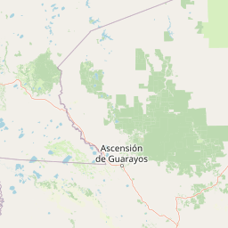
Map view of Área Natural de Manejo Integrado Humedales del Norte

Use this park location map to pinpoint Área Natural de Manejo Integrado Humedales del Norte in Bolivia, understand its exact geographic position, and read its mapped placement within the surrounding landscape more clearly.

Pigeon | © OpenStreetMap contributors

Location context for Área Natural de Manejo Integrado Humedales del Norte

Santa Cruz
Park atlas

Compare regional protected areas and surrounding Amazonian floodplain landscapes.

Other Parks Near Área Natural de Manejo Integrado Humedales del Norte

Browse nearby protected areas and adjacent lowland reserves to compare regional ecosystems beyond Área Natural de Manejo Integrado Humedales del Norte. Evaluating connected wetland geography helps place tropical river basins and conservation zones into a broader geographic perspective.
National parkCochabamba Department
About 123 km away#1 closest

Southwest

Carrasco National Park: National Park Status and Protected Landscape Geography

Explore mapped boundaries within Cochabamba Department.

Carrasco National Park, situated within the Cochabamba Department, represents a critical national park entity. This focus provides users with an atlas-centric view of its protected landscape, detailing its geographic significance and mapped features. Understand the park's terrain and regional context, offering a clear perspective on its conservation value and mapped presence.

Area
6,226 km²
Established
1991
IUCN
II
Relief
Mountain
Protected landscapeBeni
About 135 km away#2 closest

Northwest

Parque Municipal y Área Natural de Manejo Integrado Gran Mojos: Regional Geography

Protected floodplain ecosystems in the Beni department of Bolivia.

Analyze the spatial distribution of this large protected area located in the Mamoré River basin. Learn about its dual-designation structure, bridging core municipal forests with integrated management zones that preserve vital lowland Amazonian habitats and endemic biodiversity within the Llanos de Moxos ecoregion.

Area
5,804.3 km²
Established
2017
Relief
Lowland
Scope
Terrestrial
National parkSanta Cruz Department
About 138 km away#3 closest

South

Amboró National Park: Its Protected Area Identity and Geographic Context

Mapped boundaries and regional landscape details.

Amboró National Park is a designated national park situated within the Santa Cruz Department, Bolivia. This entry provides detailed insights into its protected landscape, focusing on its geographical significance and mapped boundaries. Users can explore how Amboró National Park fits into the broader regional geography, enhancing their understanding of conservation areas and mapped natural terrains for atlas-based research and discovery. Its specific location and protected status are crucial for understanding its ecological and geographic role.

Area
4,425 km²
Established
1984
IUCN
II
Relief
Mountain
A watercolor painting showing a soft, atmospheric landscape with a winding river, green banks, trees, and distant low hills against a white background.
Protected areaBeni Department
About 161 km away#4 closest

Northwest

Área Protegida Municipal Ibare-Mamoré: Geography and Protected Area Context

Riverine landscapes and wetlands in Bolivia's Beni Department

The Área Protegida Municipal Ibare-Mamoré encompasses a diverse range of ecosystems, from upland forests to open grasslands and shifting river channels. As a key conservation unit near the city of Trinidad, this area highlights the ecological importance of the Llanos de Moxos region through its interconnected aquatic and terrestrial habitats.

Area
256.08 km²
Established
2011
Relief
Lowland
Climate
Tropical
A soft watercolor painting showing a winding river through a valley with trees and palms on the banks and rolling hills in the background.
Nature reserveSanta Cruz
About 192 km away#5 closest

Southeast

Parque de Protección Ecológica del Río Piraí: Protected Geography and Riverine Landscapes

Nature reserve and flood-control corridor in Santa Cruz, Bolivia

This nature reserve encompasses a narrow, sediment-rich corridor following the Río Piraí. It protects representative lowland habitats including Chiquitano dry forest and gallery woodlands, while balancing vital flood-mitigation roles against the pressures of urban expansion. Explore the map of this unique alluvial landscape to understand its ecological significance and role in the regional geography of Santa Cruz.

Area
15.868 km²
Established
1991
Relief
Lowland
Climate
Tropical
National parkBolivia
About 213 km away#6 closest

West

Isiboro Sécure National Park and Indigenous Territory: Bolivian Protected National Park Atlas

Mapped protected boundaries and regional landscape context.

Investigate Isiboro Sécure National Park and Indigenous Territory as a key protected national park within Bolivia's expansive geography. This resource offers detailed views of its mapped natural landscape and its regional significance as a protected area. Understand the park's geographic attributes and its contribution to the country's conservation atlas through structured map-based exploration.

Area
13,721.8 km²
Established
1965
IUCN
II
Relief
Mixed relief
A watercolor painting showing a landscape of sandy dunes, small pools of water, and green vegetation against a white background.
Regional parkSanta Cruz
About 217 km away#7 closest

Southeast

Parque Regional Lomas de Arena: Protected Landscapes and Geographic Features

Inland dune and Chaco forest ecosystems in the Santa Cruz lowlands

Covering 14,000 hectares near Santa Cruz de la Sierra, Parque Regional Lomas de Arena showcases a rare inland sand dune field anchored by transitional Chaco forest and savanna. This protected area provides a unique window into the geography of the Bolivian lowlands, where lagoon habitats and sandy ridges create a distinct ecological mosaic that bridges historical Chané heritage with modern conservation efforts.

Area
140.759 km²
Established
1989
IUCN
V
Relief
Lowland
Wildlife reserveSanta Cruz
About 226 km away#8 closest

Northeast

Reserva de Vida Silvestre Ríos Blanco y Negro: Protected Area Geography and Landscape Map

Transitional lowland forests and river floodplains in Santa Cruz

The Reserva de Vida Silvestre Ríos Blanco y Negro protects a massive stretch of lowland forest in northeastern Bolivia. This area is characterized by its transitional ecology where dry forests meet the Amazon, shaped by the dynamic flooding of the San Pablo and Blanco rivers. Access this detailed geographic overview to understand the conservation significance and territorial extent of this critical wetland and forest environment.

Area
14,000 km²
Established
1990
Relief
Lowland
Climate
Tropical

Common questions about visiting, size, designation, and location context for Área Natural de Manejo Integrado Humedales del Norte

Área Natural de Manejo Integrado Humedales del Norte FAQs for park facts, access, geography, and protected area context

Find quick answers about Área Natural de Manejo Integrado Humedales del Norte, including protected-area facts, park geography, trail and visitor context, and how the park fits into its surrounding country and regional landscape.
MoriAtlas Explorer

Continue Your Protected Areas Search Across the Global Atlas

Deepen your exploration by continuing the structured search for national parks and protected areas worldwide. Utilize the comprehensive filtering capabilities to compare different conservation landscapes and refine your understanding of global park geography. Discover more about the distribution and characteristics of protected natural areas.

Global natural geography