
Mori Atlas logo
Wildlife reserveRiverside Mountains Wilderness

Examining the rugged mountain peaks, desert washes, and river corridor geography within this protected wilderness

Riverside Mountains Wilderness: A Geologically Distinctive Desert Protected Landscape in California

Riverside Mountains Wilderness sits along the eastern edge of the Colorado Desert in California, offering a protected landscape defined by steep craggy interiors and broad, gently sloping bajadas. This desert reserve protects a diverse mosaic of rocky mountain terrain, narrow canyons, and dry wash systems positioned immediately west of the Colorado River. The area provides essential habitat for sensitive desert cactus species and localized mule deer populations, anchoring its significance as a geological feature within the Maria Fold and Thrust Belt.

desert wildernessBLM wildernessColorado DesertSonoran DesertColorado River corridorrugged mountains
Digital illustration of a mountain valley featuring a waterfall cascading down rocky cliffs into a winding river that flows through green fields, with stylized evergreen trees in the foreground.

Riverside Mountains Wilderness

Wildlife reserve

Park overview

Structured park overview, official facts, and landscape profile for Riverside Mountains Wilderness

Riverside Mountains Wilderness park facts, protected area profile, and essential visitor context

Review the core facts for Riverside Mountains Wilderness, including designation, size, terrain, visitor scale, habitats, and operating context in one park-focused overview.

About Riverside Mountains Wilderness

Riverside Mountains Wilderness occupies a compact but visually dramatic stretch of the California desert, where the Riverside Mountains rise abruptly from the surrounding Colorado Desert lowlands. The wilderness takes in roughly 24,004 acres of public land managed by the Bureau of Land Management, with the Colorado River tracing its eastern edge across the Arizona border. The protected area sits near Vidal Junction in the Lower Colorado River Valley, southeast of the Turtle Mountains and north of the Big Maria Mountains, placing it at the heart of a series of small desert ranges that define regional scenery in far eastern Riverside County.

The landscape within the wilderness is defined by contrast. Broad, gently sloping bajadas, formed by accumulated sediment at the base of the mountains, give way to steep and rugged interior terrain as elevations rise toward numerous small peaks. Washes emerging from canyons divide the lower bajadas, creating a network of dry drainages that shape movement through the area and contribute to its rough, dissected appearance. Although the mountains themselves are modest in elevation, with the highest point reaching approximately 2,252 feet, their exposed rocky faces and frequent crags give the range a notably rugged character for its size.

Beyond its surface scenery, the wilderness carries significant geological value as part of the Maria Fold and Thrust Belt. The range preserves exposures of both the upper and lower plates of a major detachment fault and metamorphic core complex system associated with Miocene-age crustal extension. The underlying geological history includes Cretaceous-age north-south compression and later extension along the Colorado River corridor, producing an unusual structural setting that distinguishes these mountains from much of the surrounding North American Cordillera. This combination of desert mountain scenery, river-bordering geography, and complex bedrock geology gives Riverside Mountains Wilderness a distinctive identity among California's BLM wilderness areas.

Quick facts and research context for Riverside Mountains Wilderness

Riverside Mountains Wilderness is a 24,004-acre BLM-managed desert wilderness in Riverside County, California, established in 1994. It sits along the Colorado River in the Lower Colorado River Valley and falls within both the Colorado Desert and Sonoran Desert regions. The terrain ranges from gentle bajadas to steep, craggy interior peaks, with the high point of the underlying Riverside Mountains reaching roughly 2,252 feet. Geologically, the range is part of the Maria Fold and Thrust Belt and contains exposures of both upper and lower plates of a major detachment fault system. The wilderness is also notable for sensitive plant species, including foxtail cactus and California barrel cactus, and for a small resident herd of desert mule deer.

Protection and recognition

Examine terrestrial protection scope and documented conservation status details.

Riverside Mountains Wilderness Protection Status and Geographic Designation

Riverside Mountains Wilderness maintains a documented terrestrial protection scope within its designated natural landscape boundary. Factual records outline administrative governance parameters without referencing unverified international recognition programs or external funding frameworks.

Protection details

Protection scope
Terrestrial
Transboundary protection
No
Park context

Deeper park guide and search-rich context for Riverside Mountains Wilderness

Riverside Mountains Wilderness history, landscape, wildlife, and travel context

Explore Riverside Mountains Wilderness through its history, landscape character, ecosystems, wildlife, conservation priorities, cultural context, and seasonal travel timing in a structured park guide built for atlas discovery and search intent.

Why Riverside Mountains Wilderness stands out

Riverside Mountains Wilderness is best known for its rugged, craggy desert peaks rising just west of the Colorado River, and for its position within the Maria Fold and Thrust Belt, one of the most geologically distinctive regions in the California desert. The wilderness showcases a classic transition between steep rocky mountain interiors and broad desert bajadas, threaded with washes emerging from narrow canyons. It is also recognized for protecting sensitive Sonoran and Colorado Desert plant species, particularly the foxtail cactus and California barrel cactus, in a relatively small but ecologically meaningful BLM-managed landscape.
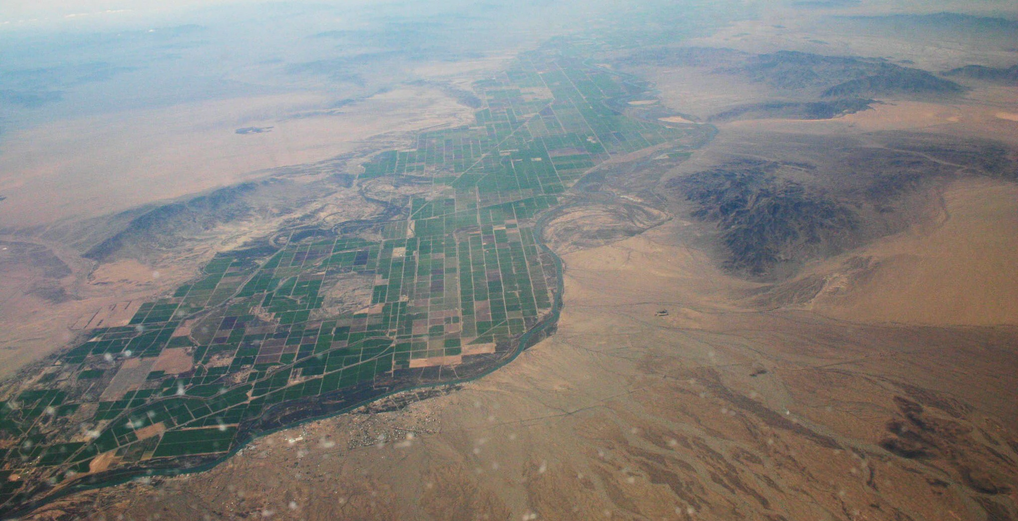
An oblique aerial view looking south over Parker Valley, showing a stark contrast between green agricultural fields and surrounding brown desert landscape.
An aerial view of the Parker Valley area, featuring irrigated agricultural land alongside the arid terrain of the Riverside Mountains.

Riverside Mountains Wilderness history and protected-area timeline

Riverside Mountains Wilderness was formally established in 1994 as part of the broader system of Bureau of Land Management wilderness designations across the California desert. Its establishment recognized the outstanding geological, scenic, and ecological values of the Riverside Mountains, a small but rugged range that had long been part of the public lands surrounding the Lower Colorado River Valley. Management responsibility fell to the BLM, which continues to administer the area within the framework of desert wilderness conservation.

The mountains themselves have a much longer geological history, having formed as part of the Maria Fold and Thrust Belt during Cretaceous crustal shortening, and later reshaped by Miocene-age extension that exposed deep metamorphic rocks through detachment faulting. These features, rather than any single human historical event, form the deeper history of the landscape preserved by the wilderness designation.

Riverside Mountains Wilderness landscape and geographic character

The landscape of Riverside Mountains Wilderness is built around the contrast between broad desert bajadas and the steep, craggy interior of the Riverside Mountains. Bajadas, the gently sloped aprons of sediment that fan outward from the mountain base, dominate much of the lower terrain. As elevation increases, these slopes give way to rugged hills and numerous small peaks whose exposed rocks lend the range its rough, broken appearance.

Washes cut through the bajadas, emerging from canyons higher in the range and creating natural pathways between rocky ridges and open desert flats. The overall effect is a tightly woven mosaic of dry drainages, rocky slopes, and sheltered canyon pockets, all within a small geographic footprint. With the Colorado River running along the eastern side of the range, the wilderness blends classic interior desert mountain scenery with the visual impact of an adjacent major river corridor.

Riverside Mountains Wilderness ecosystems, habitats, and plant life

Ecologically, Riverside Mountains Wilderness sits at an interesting interface between the Colorado Desert and the Sonoran Desert, two regional subdivisions of the broader North American warm desert system. This positioning gives the area transitional desert vegetation patterns, with plant communities shaped by low elevation, aridity, and the moderating influence of the nearby Colorado River corridor.

The bajadas and rocky slopes support a mix of desert scrub and cactus-dominated plant assemblages typical of the southeastern California desert. Canyon microhabitats and shaded rock outcrops provide refuge for more specialized vegetation, while the washes function as ecological corridors that concentrate both moisture and biological activity. The wilderness also harbors sensitive plant species whose limited distributions contribute to the conservation value of the area.

Riverside Mountains Wilderness wildlife and species highlights

Wildlife in Riverside Mountains Wilderness reflects the broader pattern of the California desert, where animal populations are often sparse but well adapted to extreme aridity and rocky terrain. The most frequently highlighted resident species is a small herd of mule deer in the local desert subspecies, sometimes referred to as burro deer. These animals move through the washes, bajadas, and rugged slopes of the range, using the varied terrain for cover and forage.

The proximity of the Colorado River adds another dimension to the area's wildlife character, as visitors and wildlife alike move between the mountains and the river's edge. Reptiles, small mammals, and a range of desert-adapted bird species typical of the Sonoran and Colorado Deserts are likely present across the varied habitat mosaic, though the wilderness is most specifically noted for its deer population and the sensitive plant communities on which desert wildlife depends.

Riverside Mountains Wilderness conservation status and protection priorities

Riverside Mountains Wilderness was designated in 1994 to protect a representative desert mountain landscape under Bureau of Land Management stewardship, balancing wilderness character with long-term conservation of geological and biological resources. The wilderness preserves a relatively intact example of the rugged terrain, bajadas, and canyon systems that define the Riverside Mountains, while also safeguarding habitats for sensitive desert species.

A particular focus of conservation attention is the protection of two sensitive cactus species, the foxtail cactus and the California barrel cactus, both of which are highlighted as important elements of the area's botanical value. The wilderness also supports a small, locally significant herd of desert mule deer, reinforcing the importance of habitat connectivity and minimal disturbance across the range. By placing these features within a formal wilderness designation, the BLM helps ensure that future management maintains the area's ecological and geological integrity.

Riverside Mountains Wilderness cultural meaning and human context

The Riverside Mountains Wilderness lies within a part of the California desert that has long been tied to travel, settlement, and crossing points along the Colorado River. The nearby community of Vidal and the broader Vidal Junction area served as small-scale waypoints in the Lower Colorado River Valley, with the river itself functioning as a historic corridor between California and Arizona. The mountains themselves have been part of the regional backdrop for this desert travel and settlement pattern, though the wilderness today is valued primarily for its natural and geological character rather than for concentrated cultural development within its boundaries.

Top sights and standout views in Riverside Mountains Wilderness

Among the strongest distinguishing features of Riverside Mountains Wilderness are its numerous rugged peaks, dense network of washes, and the sharply contrasting transition from broad bajadas to steep interior crags. The Colorado River's close parallel along the eastern edge gives the wilderness a striking river-to-mountain visual relationship uncommon among California desert preserves. The area's position within the Maria Fold and Thrust Belt also makes it a noteworthy destination for understanding the unusual geological history of the southeastern California desert, while its populations of sensitive cacti and desert mule deer anchor its biological significance.

Best time to visit Riverside Mountains Wilderness

Like much of the southeastern California desert, Riverside Mountains Wilderness experiences very hot summers and mild winters, and the cooler months generally offer the most comfortable conditions for exploring the area's bajadas, washes, and rocky interior terrain. Winter and early spring typically bring lower temperatures and clearer skies, with Spring also bringing conditions that may showcase seasonal changes in desert vegetation.

Summer heat in this part of the Colorado Desert can be intense, especially in the open bajada zones, so most visitors find the cooler half of the year far more suitable for longer hikes or extended exploration. Wildlife observation and appreciation of the surrounding river landscape also tend to be easier when temperatures are moderate, making the non-summer months the most broadly appealing window for a meaningful visit.
Monthly climate preview

Long-term representative monthly temperature and precipitation data for Riverside Mountains Wilderness

Riverside Mountains Wilderness Climate Normals and Annual Temperature Rhythm

Representative coordinate records show measured multi-year monthly temperature variations and precipitation averages across Riverside Mountains Wilderness. Opening the complete twelve-month profile provides detailed weather by month data and comprehensive long-term climatology metrics.
Annual mean23 °C
11 °C35 °C
Jan12°
Feb14°
Mar17°
Apr21°
May26°
Jun31°
Jul35°
Aug34°
Sep31°
Oct24°
Nov16°
Dec11°
Warmest month
July

34.7 °C

Coolest month
December

11 °C

Wettest month
February

0.8 mm/day

Driest month
June

0 mm/day

Park location guide

Geography guide, regional context, and park location map for Riverside Mountains Wilderness

Riverside Mountains Wilderness park geography, regions, and map view in United States of America

Understand where Riverside Mountains Wilderness sits in United States of America through a broader geographic reading of the surrounding landscape, nearby location context, and its mapped position within the national park landscape.

How Riverside Mountains Wilderness fits into United States of America

The United States of America is a federal presidential republic and one of the world's largest countries by area and population. It consists of 50 states across a vast territory spanning multiple time zones, with its capital in Washington, D.C. and largest city in New York City. The nation has a diverse economy, influential political system, and significant cultural and military presence globally.

Wider geography shaping Riverside Mountains Wilderness in United States of America

The United States occupies a vast territory in North America, bordered by Canada to the north and Mexico to the south. The 48 contiguous states stretch from the Atlantic to the Pacific Ocean, while Alaska occupies the northwestern region and Hawaii is an archipelago in the Pacific. The country encompasses diverse terrain including the Rocky Mountains, Appalachian Mountains, Great Plains, and extensive river systems.

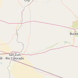
Map view of Riverside Mountains Wilderness

Use this park location map to pinpoint Riverside Mountains Wilderness in United States of America, understand its exact geographic position, and read its mapped placement within the surrounding landscape more clearly.

Pigeon | © OpenStreetMap contributors

Visual reference guide highlighting desert bajadas, rocky mountain terrain, and protected river-bordering habitats

Riverside Mountains Wilderness Photos and Rugged Desert Landscape Scenery

Visual documentation reveals the stark contrast between broad desert bajadas and steep rocky peaks within Riverside Mountains Wilderness. Detailed protected area imagery exposes canyon networks, sensitive cactus habitats, and the unique geological character along the Colorado River corridor.

An oblique aerial view looking south over Parker Valley, showing a stark contrast between green agricultural fields and surrounding brown desert landscape.

Park atlas

Compare adjacent protected areas and regional desert geography

Parks Near Riverside Mountains Wilderness and Surrounding Desert Landscapes

Browse protected areas and rugged desert terrain surrounding Riverside Mountains Wilderness. Expanding the geographic scope reveals connected conservation landscapes and regional park networks.
National parkCalifornia
About 67 km away#1 closest

West

Joshua Tree National Park: Mapped Protected Landscape and Regional Geography in California

Explore unique park boundaries and natural terrain across Southern California.

Joshua Tree National Park is a vital protected area in California, known for its distinctive natural landscape and geographic setting. This entry provides detailed information on the park's mapped boundaries and the unique terrain it encompasses, serving as a key point for atlas exploration of protected lands. Understand the regional geography and the specific character of this significant national park.

Area
3,217.9 km²
Established
1994
IUCN
II
Visitors
3.1M annual
Wildlife reserveCalifornia
About 107 km away#2 closest

South

Indian Pass Wilderness: Protected Sonoran Desert Geography and Terrain Mapping

Analyzing desert mountain slopes and riparian corridors in California

Indian Pass Wilderness represents a key protected-area unit where the arid Chocolate Mountains descend into the Lower Colorado River Valley. The area is defined by its dramatic drainage patterns, including Julian Wash, and its role as a transition zone between desert upland and riparian edge, serving as a critical study for understanding southwestern desert geography and protected landscape boundaries.

Area
131.19 km²
Established
1994
IUCN
Ib
Relief
Mountain
Wildlife reserveCalifornia
About 111 km away#3 closest

South

Little Picacho Wilderness: Exploring the Protected Volcanic Terrain and Desert Geography

A rugged wilderness reserve in southeastern California

Little Picacho Wilderness is a protected desert landscape located along the lower Colorado River corridor. The area is defined by dramatic volcanic ridges, Picacho Peak, and extensive arid desert washes. This wildlife reserve serves as an important refuge for desert bighorn sheep, desert tortoises, and free-roaming wild horse herds, offering a clear window into the rugged geography of the Sonoran Desert.

Area
154.65 km²
Established
1994
IUCN
Ib
Relief
Mountain
A soft watercolor illustration depicting a panoramic desert landscape with prominent rugged purple mountains in the background, rolling green hills in the midground, and saguaro cacti in the foreground.
Wildlife reserveArizona
About 112 km away#4 closest

Southeast

Eagletail Mountains Wilderness: Mapping Arizona Sonoran Desert Protected Areas

Remote ridgelines and desert basin geography in central Arizona.

Analyze the desert mountain terrain of the Eagletail Mountains Wilderness. This protected area features jagged rocky peaks, open desert plains, and a unique position near the Bouse Wash headwaters, making it a key study for Arizona desert geography and arid-land preservation.

Area
407 km²
IUCN
Ib
Relief
Mountain
Climate
Arid
Wildlife reserveArizona
About 114 km away#5 closest

North

Mount Nutt Wilderness: Mapping the Volcanic Canyons and Desert Landscapes of Arizona

A protected wilderness area in the central Black Mountains

Mount Nutt Wilderness offers a dramatic look at high desert topography, characterized by fortress-like volcanic formations and deeply incised canyons. This protected area in northwestern Arizona provides essential habitat for desert bighorn sheep while showcasing the contrast between sun-baked mesas and lush, spring-fed riparian zones.

Area
114 km²
Established
1990
IUCN
Ib
Water
Minor water
A watercolor painting showing a soft-toned landscape with a winding river in the foreground, a forested middle ground, and rolling mountains in the distance.
Protected landscapeUnited States of America
About 127 km away#6 closest

North

Lake Mead National Recreation Area: Desert Reservoir and Protected Landscape Atlas

United States protected geography and reservoir terrain

Spanning the lower Colorado River, Lake Mead National Recreation Area represents a unique convergence of desert ecosystems and large-scale water management. Its geography includes extensive reservoir shorelines, deep canyon corridors, and volcanic basin terrain that provide a foundational look at the arid environments of the American Southwest. The area remains a significant study of how engineered water features alter and interact with complex desert landscapes.

Area
6,053.31 km²
Established
1936
IUCN
V
Visitors
6.4M annual
Watercolor painting of a desert scene with rolling hills in the background and saguaro cacti in the foreground.
Wildlife reserveMaricopa County
About 133 km away#7 closest

East

Hummingbird Springs Wilderness: A Protected Sonoran Desert Landscape in Maricopa County

Rugged mountain terrain and desert wash networks

Spanning more than 31,000 acres, Hummingbird Springs Wilderness serves as a core protected area in the Sonoran Desert. The geography encompasses the Belmont Mountains, providing a stark contrast of arid peaks and sandy basins that extend through western Maricopa County. This roadless wilderness represents an essential connection between adjacent protected lands, maintaining a vast and isolated desert environment shaped by centuries of geological forces.

Area
126.26 km²
Established
1990
IUCN
Ib
Relief
Mountain
Watercolor painting of a calm lake surrounded by green forests and distant mountain ridges.
Protected areaArizona
About 160 km away#8 closest

East

Prescott National Forest: Geographic Overview of Arizona Protected Landscapes and Wilderness

Regional geography and protected terrain map of the Bradshaw Mountains

Spanning over one million acres, Prescott National Forest represents a defining outdoor landscape in Arizona. The terrain transitions from high desert chaparral to dense ponderosa pine forests, featuring eight distinct wilderness areas, rugged canyon systems, and essential watershed corridors that shape the regional ecology near Prescott.

Area
5,100 km²
Established
1908
Relief
Mountain
Climate
Temperate

Common questions about visiting, size, designation, and location context for Riverside Mountains Wilderness

Riverside Mountains Wilderness FAQs for park facts, access, geography, and protected area context

Find quick answers about Riverside Mountains Wilderness, including protected-area facts, park geography, trail and visitor context, and how the park fits into its surrounding country and regional landscape.
MoriAtlas Explorer

Continue Your Protected Areas Search Across the Global Atlas

Deepen your exploration by continuing the structured search for national parks and protected areas worldwide. Utilize the comprehensive filtering capabilities to compare different conservation landscapes and refine your understanding of global park geography. Discover more about the distribution and characteristics of protected natural areas.

Global natural geography