
Mori Atlas logo
Nature reserveRöhrsberg - Hasenwinkel - Mühlberg

Analyzing the geological boundaries of limestone hills, dolomite ridges, and beech forests.

Röhrsberg - Hasenwinkel - Mühlberg: A Protected Nature Reserve in the Thuringian Landscape

(FFH-Gebiet Röhrsberg – Hasenwinkel – Mühlberg)

The Röhrsberg - Hasenwinkel - Mühlberg protected area encompasses a diverse geological mosaic within the western Eichsfeld region of Thuringia. This site comprises fragmented forest and open habitats, featuring wave-limestone hills and Zechstein dolomite ridges that support extensive beech woodlands, juniper heaths, and calcareous grasslands. Its geography serves as a vital transition zone, anchoring local conservation networks through specialized habitats for diverse bat populations and orchid-rich flora.

Natura 2000beech forestcalcareous grasslandjuniper heathlimestonedolomite
A flat vector illustration showing a sunny, mountainous landscape with limestone cliffs, evergreen trees, and a grassy meadow in the foreground.

Röhrsberg - Hasenwinkel - Mühlberg

Nature reserve

Park overview

Structured park overview, official facts, and landscape profile for Röhrsberg, Hasenwinkel, Mühlberg

Röhrsberg, Hasenwinkel, Mühlberg park facts, protected area profile, and essential visitor context

Review the core facts for Röhrsberg, Hasenwinkel, Mühlberg, including designation, size, terrain, visitor scale, habitats, and operating context in one park-focused overview.

About Röhrsberg, Hasenwinkel, Mühlberg

Röhrsberg – Hasenwinkel – Mühlberg is a compact yet ecologically dense Natura 2000 site in the far west of Thuringia, tucked between small villages such as Gerbershausen, Röhrig, Wahlhausen, and Asbach-Sickenberg and stretching toward the border with Hesse. The site encompasses two distinct landscape units: in the northeast, the Röhrsberg itself, a wave-limestone (Wellenkalk) hill, and in the southwest, the Hasenwinkel, a roughly three-kilometre-long Zechstein ridge with steep flanks and a crest of dolomite rock.

Forest is the heart of the protected area. About 379 hectares are covered by beech-dominated woodland, with Hainsimsen beech forest, Waldmeister beech forest, and Central European orchid-rich calcareous beech forest all represented. The conservation status of the first two is rated good, while the orchid-rich variant is in moderate to poor condition. Open habitats are scarcer, making up roughly 24 hectares of grassland on 83 separate plots, yet they are disproportionately important for biodiversity, with juniper heaths, calcareous semi-dry meadows, and grassy complexes interspersed with limestone pioneer vegetation forming intricate small-scale mosaics.

What elevates the site beyond a typical beech forest reserve is the layered network of protection that encloses it: a Habitats Directive site at the European level, a nature reserve at the regional level, a bird protection area binding large forest and open-landscape bird species, a broad landscape protection area, and a nature park embracing the wider Werrabergland. Documented management plans for forests and open land were completed in 2014 and 2018 respectively, guiding the long-term preservation of what is one of the most geologically diverse slices of the Unteres Werrabergland.

Quick facts and research context for Röhrsberg, Hasenwinkel, Mühlberg

Röhrsberg – Hasenwinkel – Mühlberg is a 451-hectare Fauna-Flora-Habitat area within the Natura 2000 ecological network of the European Union, located in the western Landkreis Eichsfeld in Thuringia, Germany. It was proposed by the Thuringian Ministry of the Environment in September 2000 and formally confirmed as part of the network in December 2004, with binding conservation targets set by the Thüringer Natura 2000-Erhaltungsziele-Verordnung of May 2008.

The site lies at elevations between roughly 250 m at the Mühlberg and 370 m at the Röhrsberg, and is composed of two separate but nearby protected areas: the Röhrsberg area in the northeast and the Hasenwinkel in the southwest. It overlaps with the Hasenwinkel nature reserve (Thuringia's protected-area number 8), the EU bird protection area Werrabergland südwestlich Uder, the Obereichsfeld landscape protection area, and the Eichsfeld-Hainich-Werratal nature park. Its IUCN category is IV, identifying it as a Habitat/Species Management Area.

Protection and recognition

Explore documented terrestrial protection metrics and official Natura 2000 listings.

Röhrsberg - Hasenwinkel - Mühlberg Protection Status and Designated Recognition Data

Röhrsberg - Hasenwinkel - Mühlberg maintains a documented terrestrial protection status established in 2008 with associated Natura 2000 recognition records. Visitors can examine the official conservation designations and administrative history tied to this protected area.

International recognition

Protection details

Protection scope
Terrestrial
Designated year
2008
Transboundary protection
No
WDPA ID
555519951
Park context

Deeper park guide and search-rich context for Röhrsberg, Hasenwinkel, Mühlberg

Röhrsberg, Hasenwinkel, Mühlberg history, landscape, wildlife, and travel context

Explore Röhrsberg, Hasenwinkel, Mühlberg through its history, landscape character, ecosystems, wildlife, conservation priorities, cultural context, and seasonal travel timing in a structured park guide built for atlas discovery and search intent.

Why Röhrsberg, Hasenwinkel, Mühlberg stands out

The site is best known for combining large, structurally rich beech forests on Buntsandstein and Muschelkalk with rare calcareous open habitats, including priority orchid-rich limestone beechwoods, juniper heaths, semi-dry grassland, and exposed dolomite rock. It is also recognized for its significance for bat conservation, especially the Bechstein's bat, the greater mouse-eared bat, and the lesser horseshoe bat. Within the Natura 2000 network, the protected area stands out for the mosaic of forest and open calcareous habitats set against the geological backdrop of the lower Werra hill country and the Eichsfeld cuestas.
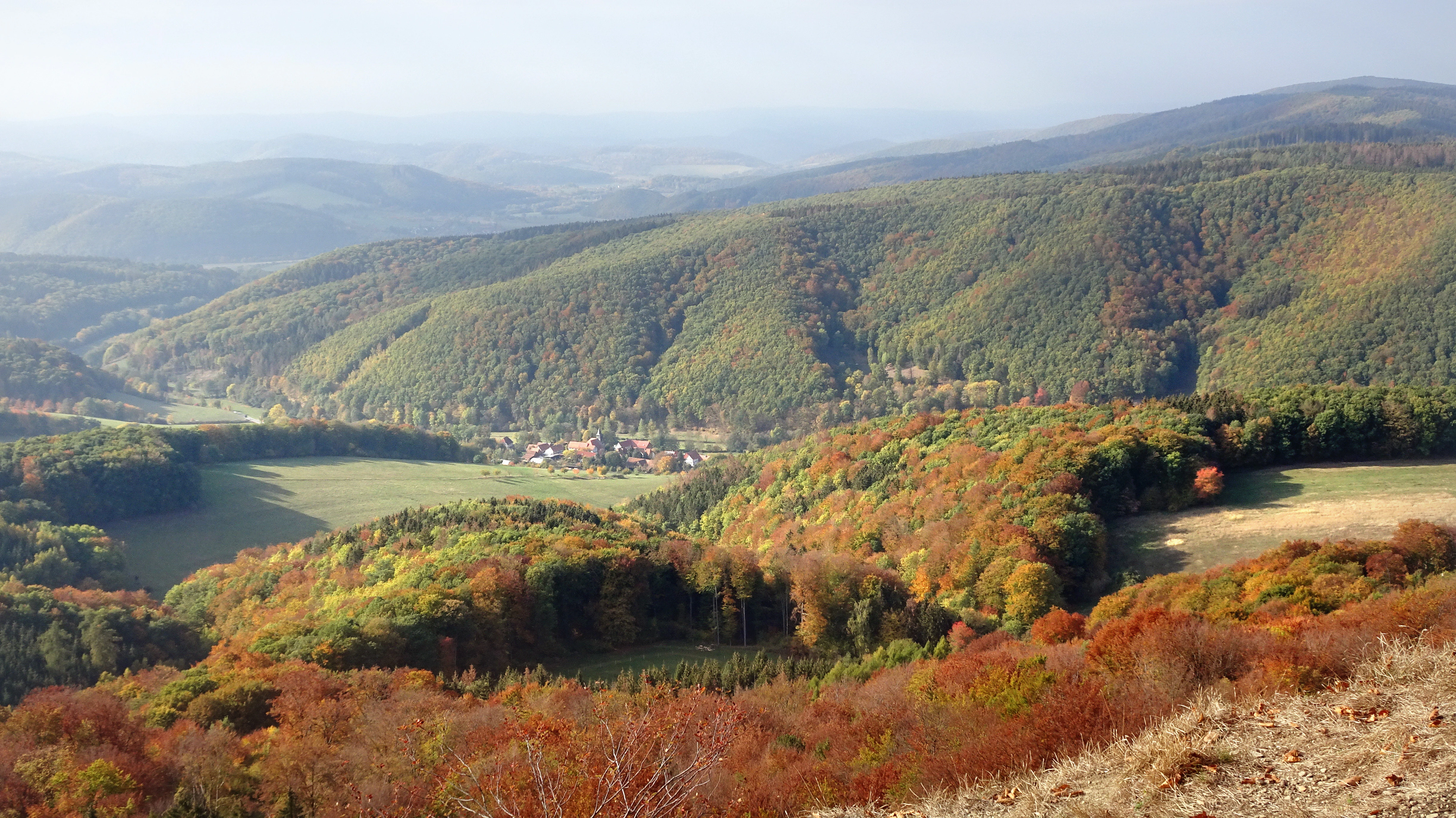
A wide aerial view of a valley with a small village surrounded by forested mountain slopes displaying autumn colors.
View of the village of Dietzenrode nestled in the valley surrounded by the forested slopes of the nature reserve.

Röhrsberg, Hasenwinkel, Mühlberg history and protected-area timeline

The Hasenwinkel, the older and more storied part of the site, was recognized for protection early in the 20th century, becoming the first area in the Eichsfeld to be placed under informal protection around 1920 because of its distinctive flora. In 1939, by order of the Prussian Regierungspräsident in Erfurt, it was formally declared a nature reserve under the Reich Nature Conservation Law, at a time when centuries of sheep grazing had kept its dolomite ridge largely treeless and its semi-dry grassland richly diverse.

The wider site came under formal protection much later. On the proposal of the Thuringian Ministry for the Environment, a large forest and grassland complex in the Landkreis Eichsfeld was reported to the European Commission in September 2000 as a candidate Fauna-Flora-Habitat area. The European Union confirmed its inclusion in Natura 2000 in December 2004, after which the Thuringian Natura 2000 Conservation Objectives Ordinance of 29 May 2008 set out binding preservation objectives. These objectives emphasize the large-scale beech forests, the linkage to the Dietzenrode bat roost, the calcareous grasslands and juniper heaths, and the dolomite rocks and calcareous tufa springs.

Forest inventories for management planning were coordinated by ThüringenForst in Gotha and published in 2014, followed by an open-land survey led by the Thüringer Landesanstalt für Umwelt und Geologie in 2017 and 2018. Within the same period, the larger Eichsfeld-Hainich-Werratal nature park had been provisionally secured under the GDR National Park Programme in March 1990 and was finally designated by Thuringian regulation in December 2011, further embedding the site in a regional conservation landscape.

Röhrsberg, Hasenwinkel, Mühlberg landscape and geographic character

The protected area sits in a transitional zone where the rolling Muschelkalk and Buntsandstein plateaus of the Eichsfeld meet the deeply incised Werra valley hill country. Elevations range from about 250 m at the Mühlberg near Wahlhausen to around 370 m at the summit of the Röhrsberg, with the Hasenwinkel ridge punctuating the southwestern portion of the site.

The Röhrsberg is a freestanding hill formed from wave-limestone (Wellenkalk), the kind of resistant residual landform characteristic of the western Eichsfeld. Across the site, the Hasenwinkel rises as a roughly three-kilometre-long, ridge-like spine of Zechstein dolomite with steep slopes on each side, shaped along the western boundary fault of a small tectonic trough. South of the Hasenwinkel, the Höhberg extends as a Buntsandstein ridge with rocky northern flanks, while the Mühlberg near Wahlhausen anchors the southern end of the protected landscape.

This combination produces a terrain that shifts abruptly from closed beech forest on gentle slopes to grassy crests, exposed dolomite rock, and sheltered cliff faces. The contrast between the dark woodland, pale limestone outcrops, and warm juniper heath is the visual signature of the area and the reason it stands out within the broader Werrabergland.
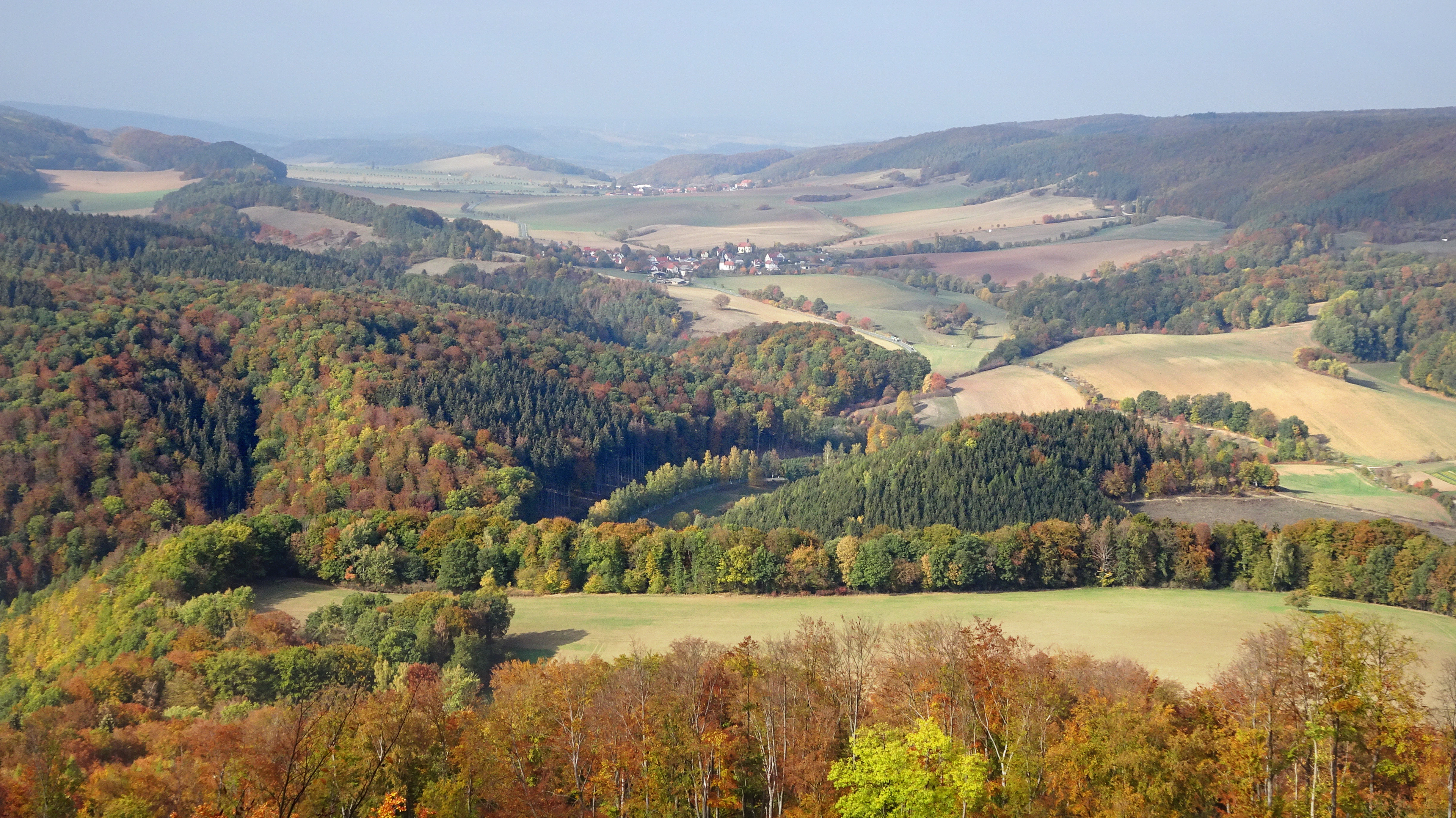
A wide, high-angle view of a rolling, forested valley in autumn with a small village nestled in the distance and colorful deciduous trees.
Autumn landscape view of the hills and valleys near Fretterode, showcasing the characteristic terrain of the Obereichsfeld region.

Röhrsberg, Hasenwinkel, Mühlberg ecosystems, habitats, and plant life

Ecologically, the protected area is defined by its unusually rich overlap of beech forest and calcareous open-land habitat types. About 379 hectares of woodland cover the majority of the site, dominated by European beech and growing across both Buntsandstein and Muschelkalk substrates, with mixed and coniferous stands making up smaller proportions.

Three beech forest habitat types of European importance are well represented: Hainsimsen beech forest (roughly 57 hectares, rated in good conservation status), Waldmeister beech forest (about 37 hectares, also in good condition), and Central European orchid-rich calcareous beech forest (about 32 hectares, in moderate to poor condition). Where the forest opens onto the dolomite crest of the Hasenwinkel or onto the calcareous slopes of the Röhrsberg, the woodland gives way to a mosaic of juniper heaths, semi-dry calcareous grassland, and mown meadows, with conspicuous complexes where heaths, dry grassland, limestone cliffs, and pioneer swards meet within just a few metres.

Priority habitat types include base-rich rupestrian grasslands, orchid-rich calcareous dry grasslands, and calcareous tufa springs; together they carry heightened European protection because much of their global range lies within the European Union. Exposed limestone rocks with fissure vegetation, spring-fed flushes, and streams with submerged aquatic vegetation further diversify the open-land habitats and contribute to the geological and ecological complexity of the protected area.
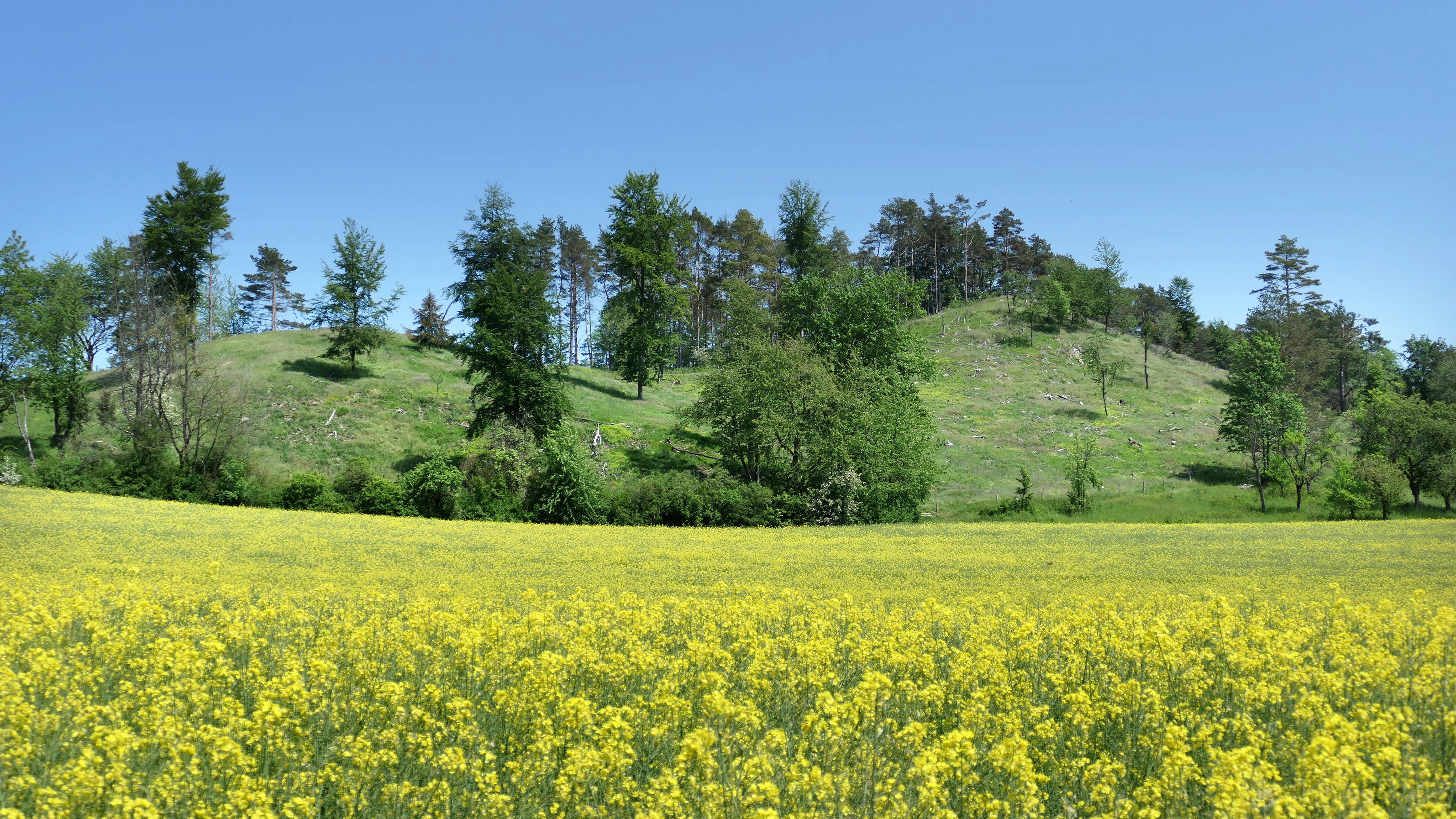
A wide landscape view of a yellow rapeseed field in front of a grassy, wooded hill under a clear blue sky.
A field of flowering yellow rapeseed in the foreground with the Zechstein ridge of the Hasenwinkel nature reserve in the background.

Röhrsberg, Hasenwinkel, Mühlberg wildlife and species highlights

Wildlife is a central reason for the site's Natura 2000 designation. Bat conservation lies at the core of the protection regime, with the Bechstein's bat and the greater mouse-eared bat listed under Annex II of the Habitats Directive and targeted for the establishment of special areas of conservation. The lesser horseshoe bat, along with the Daubenton's bat, Natterer's bat, brown long-eared bat, and grey long-eared bat, is listed under Annex IV as a strictly protected species across Europe.

The wider bird community reflects the site's overlap with the much larger EU bird protection area Werrabergland südwestlich Uder. Forest-dependent species include the black woodpecker, grey-headed woodpecker, middle spotted woodpecker, and Tengmalm's owl, while open and edge habitats support the red kite, black kite, European roller (Coracias), red-backed shrike, great grey shrike, common quail, European turtle dove, and common kingfisher. Eagle owls breed in the surrounding cliffs, and the area is a regional stronghold for these and other Annex I species.

Invertebrate diversity is unusually high for a site of this size. Among the butterflies recorded are the large purple emperor, fiery fritillary, silver-washed fritillary, marbled white, large heath, scare fritillary, and several blue and copper species, with many of them classified as endangered or near-threatened on national or regional red lists. Nocturnal moths include the yellow-green pug, hummingbird hawk-moth relatives, and several hawk and toothed moths dependent on juniper and oak woodland, while ground beetles such as Carabus species and burnet moths such as the sainfoin and thyme burnets complement the insect fauna.
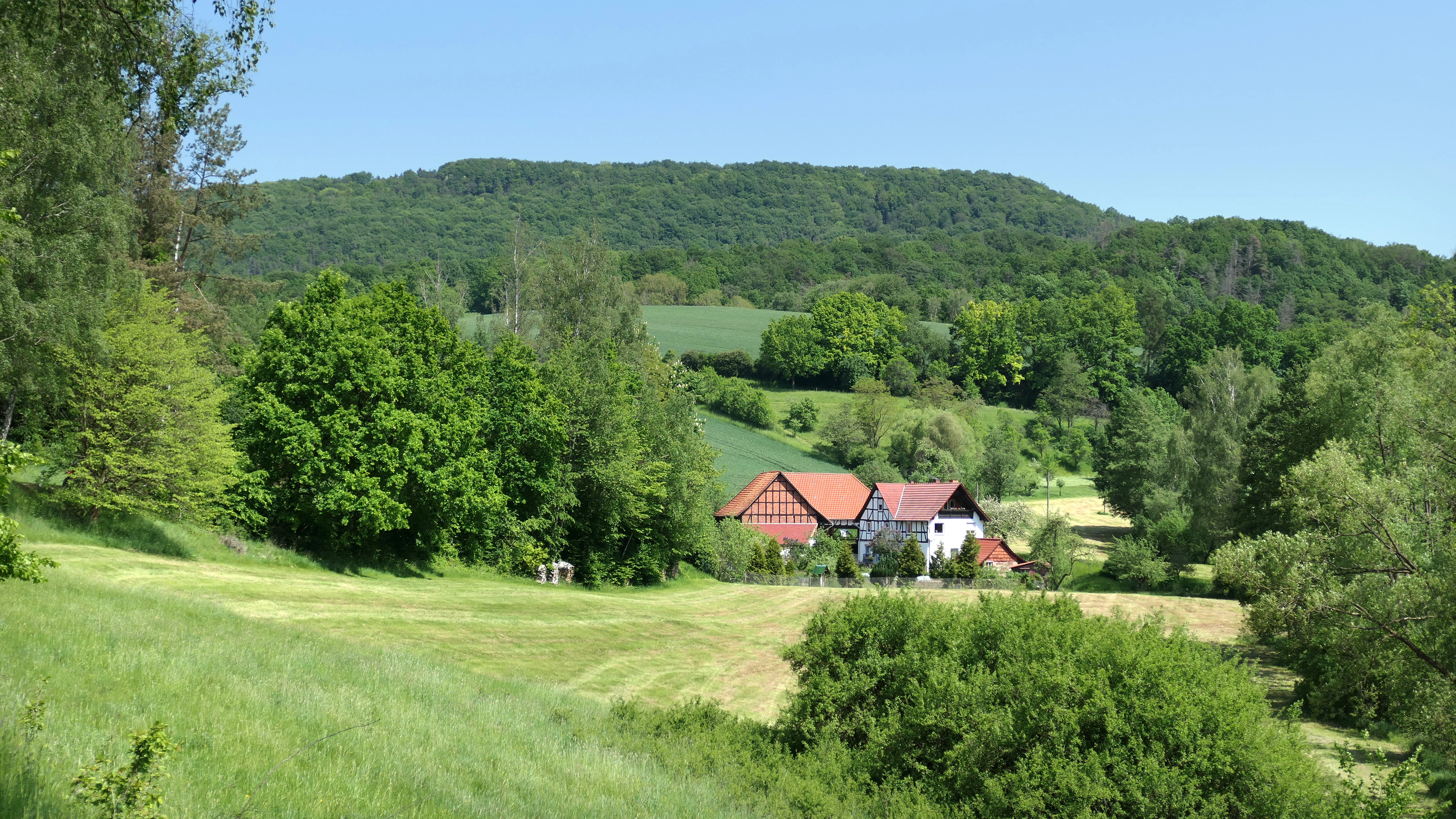
A green, rolling landscape with a forested hill in the background and a traditional half-timbered house nestled in the valley.
A scenic view of the Röhrsberg landscape near the Stubenmühle.

Röhrsberg, Hasenwinkel, Mühlberg conservation status and protection priorities

Conservation significance operates at multiple layers. As a Natura 2000 site, Röhrsberg – Hasenwinkel – Mühlberg contributes to the European Union's effort to maintain biodiversity through a connected network of protected areas, with its conservation objectives focused on the large beech forests, the functional link with the Dietzenrode bat roost in private houses, and the mosaic of calcareous grasslands and special geological features.

At the national level within Germany, several Habitats Directive Annex II and Annex IV bat species have key populations here, including some of the most habitat-sensitive species in central Europe. The Hasenwinkel, designated as a nature reserve since 1939, anchors the southwestern portion of the area and is one of the oldest formal nature reserves in the Eichsfeld. Surrounding the site, the broad Obereichsfeld landscape protection area and the extensive Eichsfeld-Hainich-Werratal nature park extend the conservation context into a 858-square-kilometre regional landscape.

Management planning reflects the layered designation: the forest plan was coordinated by the Forstliches Forschungs- und Kompetenzzentrum Gotha in 2014, and the open-land plan was completed by SALIX for the Thüringer Landesanstalt für Umwelt und Geologie in 2018. Together these plans address habitat maintenance for orchids and calcareous grasslands, bat roost protection, visitor information, and the long-term ecological balance between forest succession and traditional open-land management.

Röhrsberg, Hasenwinkel, Mühlberg cultural meaning and human context

The protected landscape is woven through centuries of human land use. The Hasenwinkel in particular was shaped by intensive sheep grazing that, through the late medieval and early modern periods, kept the dolomite ridge largely free of woody vegetation and produced the species-rich semi-dry grassland that justified its early 20th-century protection. The local limestone, dolomite, and gypsum geology, along with abundant springs, also encouraged small-scale milling and settlement patterns, hinted at in place names such as the Stubenmühle and Mühlberg.

The site is part of the broader Eichsfeld cultural landscape, a historically Catholic borderland between Thuringia and Hesse whose identity is closely tied to its small villages, agricultural traditions, and isolated woodlands. Today the area functions as both a working rural landscape and a destination for visitors interested in geology and biodiversity, with the Hasenwinkel featured as a stop on a geological route through the Eichsfeld-Hainich-Werratal nature park.

Top sights and standout views in Röhrsberg, Hasenwinkel, Mühlberg

The two separated but adjacent protected parts of the site, the Röhrsberg hill with its wave-limestone forests and the Hasenwinkel ridge with its dolomite rocks and calcareous grassland, together form a compact geological cross-section of the western Eichsfeld and lower Werra hill country. Their combination of nearly 379 hectares of beech forest, priority orchid-rich calcareous beechwoods, juniper heaths, semi-dry meadows, and exposed rock outcrops creates a habitat density rarely matched in such a small Natura 2000 site.

Equally important is the site's role in regional conservation infrastructure: it links an early 20th-century nature reserve with a modern European Habitats Directive site, a bird protection area, a landscape protection area, and a large nature park. For visitors, the 2.3-kilometre circular walk around the Hasenwinkel, with resting benches and interpretive panels, opens up this layered conservation story.

Best time to visit Röhrsberg, Hasenwinkel, Mühlberg

The protected area is accessible year-round via hiking and farm tracks, but its character shifts noticeably with the seasons. Late spring and early summer, roughly from May through June, are typically the most rewarding period for visitors interested in botany, when orchids in both the calcareous beechwoods and semi-dry grasslands are in flower and the beech canopy is still light enough for understorey plants to be seen clearly. In high summer, the exposed dolomite rocks of the Hasenwinkel become warm and dry, drawing many of the butterfly and burnet moth species for which the area is known.

Autumn brings intense colour to the mixed beech forests on the Buntsandstein and Muschelkalk slopes, and winter opens views across the snow-dusted ridges and outcrops that are otherwise hidden by foliage. The circular trail around the Hasenwinkel is most pleasant in mild weather; visitors should generally avoid trampling the semi-dry grasslands after heavy rain, when the thin soils over the dolomite are easily damaged.

Monthly climate preview

Long term temperature and precipitation patterns across representative terrain coordinates

Röhrsberg - Hasenwinkel - Mühlberg Climate Normals and Weather by Month

Historical climate records for Röhrsberg - Hasenwinkel - Mühlberg outline measured monthly averages for temperature and precipitation from 1991 to 2020. Examining the complete twelve month data profile reveals broader seasonal shifts and long term environmental rhythms across the protected area.
Annual mean8 °C
-1 °C18 °C
Jan-1°
Feb
Mar
Apr
May12°
Jun16°
Jul18°
Aug18°
Sep14°
Oct
Nov
Dec
Warmest month
July

18.2 °C

Coolest month
January

-0.9 °C

Wettest month
July

2.6 mm/day

Driest month
April

1.5 mm/day

Park location guide

Geography guide, regional context, and park location map for Röhrsberg, Hasenwinkel, Mühlberg

Röhrsberg, Hasenwinkel, Mühlberg park geography, regions, and map view in Germany

Understand where Röhrsberg, Hasenwinkel, Mühlberg sits in Germany through a broader geographic reading of the surrounding landscape, nearby location context, and its mapped position within the national park landscape.

How Röhrsberg, Hasenwinkel, Mühlberg fits into Germany

Germany is a federal republic in Western and Central Europe with a population of over 83 million across sixteen constituent states. It is Europe's largest economy by nominal GDP and a major global exporter and importer. The capital is Berlin, and the country borders Denmark, Poland, Czech Republic, Austria, Switzerland, France, Luxembourg, Belgium, and the Netherlands.

Wider geography shaping Röhrsberg, Hasenwinkel, Mühlberg in Germany

Germany is located in Western and Central Europe, spanning 357,022 km². It borders Denmark to the north, Poland and the Czech Republic to the east, Austria and Switzerland to the south, and France, Luxembourg, Belgium, and the Netherlands to the west. The country has coastlines on the Baltic Sea and North Sea to the north, with the Alps located in the southern region.

Map view of Röhrsberg, Hasenwinkel, Mühlberg

Use this park location map to pinpoint Röhrsberg, Hasenwinkel, Mühlberg in Germany, understand its exact geographic position, and read its mapped placement within the surrounding landscape more clearly.

Pigeon | © OpenStreetMap contributors

Location context for Röhrsberg, Hasenwinkel, Mühlberg

Thuringia
Recorded earthquake history

Explore Historical Earthquake Records for Röhrsberg - Hasenwinkel - Mühlberg

Examine the recorded seismic history associated with the Röhrsberg - Hasenwinkel - Mühlberg landscape. MoriAtlas provides a clear view of historical earthquake events by their epicentre distance, allowing for a better understanding of documented activity patterns within this protected area of Thuringia.

Röhrsberg - Hasenwinkel - Mühlberg Earthquake History

Catalogued events

4 events

Strongest magnitude

Magnitude 3.6

Most recent event

Oct 25, 2006

This history includes earthquakes recorded inside the park or within 50 km of its borders

Visual exploration of limestone ridges, beech forests, and dolomite rock habitats

Röhrsberg - Hasenwinkel - Mühlberg Photos, Scenery, and Protected Landscape Views

Visual records reveal the diverse terrain and protected habitats spanning the Röhrsberg - Hasenwinkel - Mühlberg protected area. Detailed photography highlights the striking contrasts between closed beech woodlands, exposed dolomite outcrops, and open calcareous grasslands.

A wide aerial view of a valley with a small village surrounded by forested mountain slopes displaying autumn colors.

Two prominent, jagged dolomite rock outcrops rise from a grassy slope, surrounded by coniferous trees under a clear blue sky.

A wide, high-angle view of a rolling, forested valley in autumn with a small village nestled in the distance and colorful deciduous trees.

A wide landscape view of a yellow rapeseed field in front of a grassy, wooded hill under a clear blue sky.

A green, rolling landscape with a forested hill in the background and a traditional half-timbered house nestled in the valley.

A wide view of a vibrant green meadow and deciduous forest covering a sloping hillside under a bright sky.

Park atlas

Compare adjacent forest reserves, limestone hills, and regional conservation areas.

Parks Near Röhrsberg - Hasenwinkel - Mühlberg and Surrounding Protected Landscapes

Browsing other protected areas near Röhrsberg - Hasenwinkel - Mühlberg reveals connected beech forests and limestone ridges across the surrounding region. Extending the geographic comparison clarifies regional habitat patterns and terrain transitions in the lower Werra hill country.
A horizontal watercolor illustration showing a soft, panoramic landscape with rolling green hills, small clumps of trees, and rocky formations on a white background.
Nature reserveLandkreis Eichsfeld
Mapped location lies within the park boundary#1 closest

Northwest

Hasenwinkel bei Fretterode: Protected Dolomite Ridge and Juniper Heath in Landkreis Eichsfeld

Nature reserve geography and landscape analysis

The Hasenwinkel bei Fretterode nature reserve is characterized by a prominent dolomite ridge rising above the agricultural lands of Landkreis Eichsfeld. This site offers an look at historically grazed calcareous grasslands and rocky outcrops. Our mapping covers its extent as a vital component of the regional protected-area network, showcasing its ecological importance and distinctive geology.

Area
0.062 km²
Established
1939
IUCN
IV
Relief
Upland
Wide watercolor illustration of green trees and hills with purple mountains in the background under a pale sky.
Nature reserveThuringia
0.7 km away#2 closest

Southeast

Stein, Rachelsberg, Gobert: A Protected Limestone Landscape in Western Thuringia

Mapping a historic nature reserve and beech forest complex

Stein, Rachelsberg, Gobert stands as a key protected area within Thuringia. This nature reserve offers deep insights into limestone ridge geography, historic border woodland continuity, and diverse habitats ranging from dry grasslands to tufa springs and orchid-rich beech forests.

Area
7.16 km²
Established
1999
IUCN
IV
Relief
Mountain
A soft watercolor illustration depicting a winding river landscape with lush trees and rolling hills in the background.
Nature reserveLandkreis Eichsfeld
About 2 km away#3 closest

West

Kelle, Teufelskanzel Nature Reserve: Geographic Overview and Protected Area Atlas

Steep slopes and sandstone ridges in Landkreis Eichsfeld

Situated along the Höheberg ridge in Thuringia, Kelle, Teufelskanzel represents a vital 200 hectare nature reserve. Its geography is defined by deep V-shaped valleys, dramatic rock outcrops like the Teufelskanzel, and a dense mix of deciduous forests that form part of the historic Inner German Border conservation zone.

Area
2.002 km²
Established
1996
IUCN
IV
Relief
Mountain
Nature reserveThuringia
About 2.6 km away#4 closest

Southeast

Stein, Rachelsberg Nature Reserve: Mapped Muschelkalk Terrain in Thuringia

Protected low mountain hills and forested karst landscapes

The Stein, Rachelsberg nature reserve in Thuringia represents a protected mosaic of Muschelkalk ridges and Buntsandstein valleys. Its geography is defined by strongly broken relief, rocky outcrops, and a unique ring of forested summits including the Dieberg and Goburg, forming an essential link in regional conservation networks across the Thuringia and Hesse border.

Area
5.06 km²
Established
2023
Relief
Mountain
Climate
Temperate
Watercolor painting of a green landscape with rolling hills, a winding path or stream, and trees on both sides against a light background.
Nature reserveWerra-Meißner-Kreis
About 4.3 km away#5 closest

Southeast

Kalkklippen südlich des Iberges Nature Reserve and Muschelkalk Landscape Atlas

Protected beech forests and active landslide topography

This nature reserve in Werra-Meißner-Kreis reveals an active Muschelkalk ridge characterized by steep limestone cliffs and boulder-strewn talus slopes. Study the site's unique ecological composition, featuring noble hardwood-rich beech forests and native European yew populations that highlight the region's complex natural history and geological significance.

Area
0.473 km²
Established
1995
IUCN
IV
Watercolor painting of a rolling forested ridge under a pale sky.
Nature reserveThuringia
About 4.5 km away#6 closest

Northeast

Lengenberg Nature Reserve: A Geographical Overview of the Eichsfeld Ridge

Protected beech and yew woodlands in Thuringia, Germany

The Lengenberg Nature Reserve forms a prominent, fully forested ridge within the Eichsfeld region of Thuringia. Renowned for hosting one of the most substantial yew populations in central Europe, the reserve showcases a geological transition between shell limestone and red sandstone. This mapping of the terrain provides insight into the ecological structure of the Eichsfeld-Hainich-Werratal area.

Area
0.26 km²
Established
1961
Relief
Mountain
Climate
Temperate
Watercolor painting of a pastoral landscape with light green hills in the distance, a field with flowering pink trees, and a pale green meadow in the foreground.
Nature reserveWerra-Meißner-Kreis
4.6 km away#7 closest

West

Ebenhöhe-Liebenberg Nature Reserve: Geography and Protected Habitat Mapping

Protected calcareous forests and dry grassland mosaic

Explore the mapped boundaries and natural terrain of the Ebenhöhe-Liebenberg nature reserve. This site provides a critical habitat mosaic including orchid-rich beech woodlands, nutrient-poor grasslands, and sandstone outcrops that form a significant conservation area within the Hessian highlands.

Area
142.48 km²
Established
1995
IUCN
IV
Relief
Upland
A soft, minimalist watercolor painting of rolling hills and trees set against a white background.
Nature reserveHessen
7.6 km away#8 closest

South

Bilstein im Höllental: Protected Diabase Cliff and Ravine Forest in Hessen

Geological landscape and Natura 2000 protected area

Discover the geographic significance of Bilstein im Höllental, a nature reserve in the Werra-Meißner-Kreis that showcases a rare juxtaposition of warm rock refuges and cool, shaded ravine environments. The reserve protects significant cliff-dwelling plant communities and traces of medieval history upon its 284-meter diabase summit, providing a focused example of geological resistance shaping valley terrain.

Area
0.032 km²
Established
1960
IUCN
IV
Relief
Mountain

Common questions about visiting, size, designation, and location context for Röhrsberg, Hasenwinkel, Mühlberg

Röhrsberg, Hasenwinkel, Mühlberg FAQs for park facts, access, geography, and protected area context

Find quick answers about Röhrsberg, Hasenwinkel, Mühlberg, including protected-area facts, park geography, trail and visitor context, and how the park fits into its surrounding country and regional landscape.
MoriAtlas Explorer

Continue Your Protected Areas Search Across the Global Atlas

Deepen your exploration by continuing the structured search for national parks and protected areas worldwide. Utilize the comprehensive filtering capabilities to compare different conservation landscapes and refine your understanding of global park geography. Discover more about the distribution and characteristics of protected natural areas.

Global natural geography