
Mori Atlas logo
Protected areaRookery Islands

Analyzing the protected rocky terrain and avian breeding habitats along the Mawson Coast

Rookery Islands Protected Area: Mapped Coastal Geography and Polar Landscape Context

The Rookery Islands comprise a scattered chain of rocky outcrops located within western Holme Bay, directly off the Mawson Coast of Mac. Robertson Land. This protected area represents a critical polar seascape characterized by low-relief terrain and essential nesting grounds for Adélie penguins and various petrel species. Positioned between the Southern Ocean and the distant snowy profiles of the David and Masson ranges, these islands serve as an internationally recognized site for observing seabird ecology within the Antarctic Treaty System.

Antarctic islandsHolme BayMawson CoastMac. Robertson LandAdélie penguinsSouthern giant petrels

Rookery Islands

Protected area

Park overview

Structured park overview, official facts, and landscape profile for Rookery Islands

Rookery Islands park facts, protected area profile, and essential visitor context

Review the core facts for Rookery Islands, including designation, size, terrain, visitor scale, habitats, and operating context in one park-focused overview.

About Rookery Islands

The Rookery Islands are a dispersed archipelago of around seventy-five rocks and small islands nestled in the western reaches of Holme Bay along the Mawson Coast of Mac. Robertson Land, in East Antarctica. The group lies north of the David Range and Masson Range, two of the prominent mountain systems that rise behind the Mawson Coast, and occupies a stretch of cold, open ocean bordered by rock, ice, and seasonal sea ice.

The largest islands in the group are Giganteus Island in the north-west, measuring roughly six hundred meters long by four hundred meters wide, and Rookery Island in the south, about one kilometer long and two hundred and fifty meters wide. Across the rest of the chain, the islands remain rocky and low, with most rising between ten and thirty meters above the sea. The tallest point reaches around sixty meters, on Rookery Island itself, while Giganteus Island rises to roughly twenty-five meters.

Beyond their physical character, the Rookery Islands carry a clear ecological identity shaped by one of the most pristine, lightly visited stretches of the East Antarctic coast. Australia's Mawson research station, the closest permanent human outpost, sits about fifteen kilometers to the east in Holme Bay, leaving the Rookery Islands effectively undisturbed by daily human activity. The combination of low rocky terrain, coastal exposures, and proximity to productive polar waters creates ideal conditions for dense seabird colonies of multiple species.

The group is now embedded in a layered conservation framework that operates on both Antarctic and global scales. It is administered under the Antarctic Treaty System, designated as Antarctic Specially Protected Area No. 102, and listed by BirdLife International as an Important Bird Area. Those protections keep the islands a benchmark site for monitoring seabird populations along an otherwise vast and difficult-to-survey coastline.

Quick facts and research context for Rookery Islands

The Rookery Islands are an uninhabited group of around seventy-five islands and rocks in western Holme Bay, East Antarctica, off the Mawson Coast of Mac. Robertson Land. Their terrain is uniformly rocky and low, generally between ten and thirty meters above sea level, with the larger islands reaching up to sixty meters. The nearest permanent settlement is the Australian research station Mawson, roughly fifteen kilometers to the east.

The group is administered under the Antarctic Treaty System and is designated as Antarctic Specially Protected Area No. 102. It is also listed as an Important Bird Area by BirdLife International, an elevation above the ordinary Antarctic coastline that works to protect colonies of Adélie penguins, several petrel species, and other seabirds.

Protection and recognition

Examine documented conservation frameworks and administrative boundaries for Rookery Islands.

Rookery Islands Protection Status and Management Scope Overview

Rookery Islands protection status details outline mixed management scopes and administrative boundaries across the designated landscape. Recorded preservation measures provide essential baseline data for analyzing conservation frameworks and international recognition records.

Protection details

Protection scope
Mixed
Transboundary protection
No
Park context

Deeper park guide and search-rich context for Rookery Islands

Rookery Islands history, landscape, wildlife, and travel context

Explore Rookery Islands through its history, landscape character, ecosystems, wildlife, conservation priorities, cultural context, and seasonal travel timing in a structured park guide built for atlas discovery and search intent.

Why Rookery Islands stands out

The Rookery Islands are best known as one of the southernmost known breeding sites for southern giant petrels, a species that does not nest anywhere else in the surrounding region. The island group is also important for its Adélie penguin colony and its mixed assemblage of petrels and skuas nesting among low rocky terrain near the Antarctic coastline. The islands' careful tier of protections has made them a small but important reference area for studying seabird populations along the Mawson Coast, particularly because the surrounding waters and ice keep human disturbance extremely low.
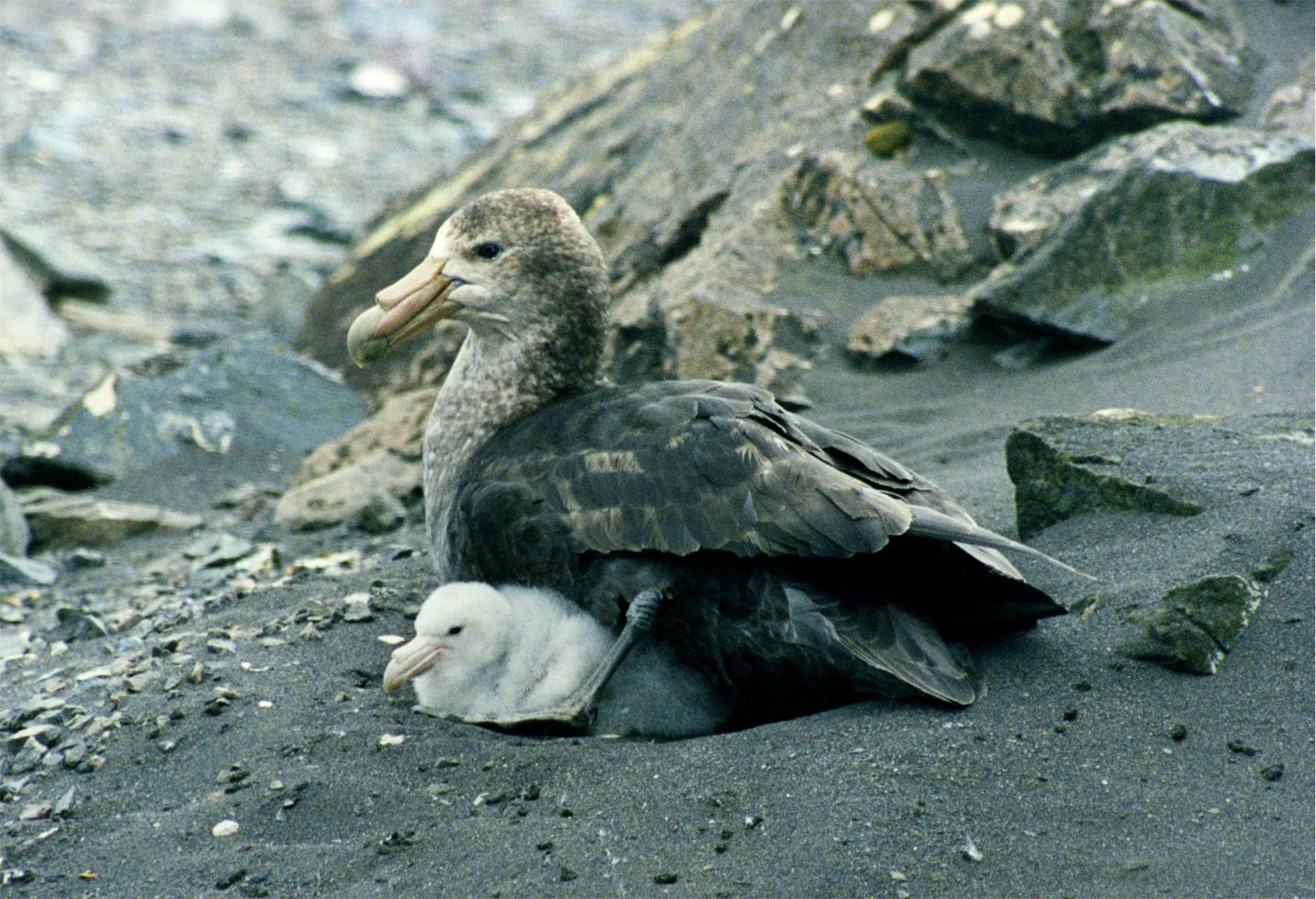
A large greyish-brown adult southern giant petrel sitting on dark, rocky ground with a small, fluffy white chick tucked beside it.
A southern giant petrel resting with its chick on the rocky shores of Rookery Islands.

Rookery Islands landscape and geographic character

The Rookery Islands sit within a striking polar seascape where rock meets sea ice along the Mawson Coast. The larger landmasses of East Antarctica rise inland as the David Range and Masson Range, while the islands themselves form a low scattered fringe between open water and the continent. The result is a layered view from afar: distant snowy peaks, broken coastal ice, and a constellation of dark rocky islands in the foreground.

The terrain of the islands is uniformly rocky and of low relief, an arrangement that exposes the rocks to wind, spray, and seasonal ice but provides the elevated, clear ground that seabirds prefer for nesting. Giganteus Island anchors the north-west of the group with a rounded profile around twenty-five meters in height, while Rookery Island dominates the south with ridges reaching up to sixty meters, giving the southern end of the chain the most pronounced topography. Smaller islands throughout the group generally rise between ten and thirty meters, creating a varied but consistently low silhouette.

Rookery Islands ecosystems, habitats, and plant life

The islands belong to the cold, ice-influenced marine environment of the Mawson Coast, where seasonal sea ice, open water, and rocky coastline combine to support rich polar seabird life. Vegetation on the islands is limited by Antarctic conditions, and the biological richness of the area is concentrated around the breeding seabirds that use the rocks as nesting substrate.

The ecosystem is fundamentally marine-based, fed by the productivity of the surrounding Southern Ocean. The islands function as raised, ice-free refuges where breeding adults can nest above the waves while foraging in nearby cold, nutrient-rich waters. The combination of open ocean access and undisturbed nesting terrain gives the Rookery Islands an ecological character distinct from nearby ice-bound or continental sites.

Rookery Islands wildlife and species highlights

The Rookery Islands support breeding colonies of Adélie penguins, Cape petrels, snow petrels, Wilson's storm petrels, Antarctic skuas, and southern giant petrels. Adélie penguins are the most prominent species in terms of the site's formal conservation recognition, with the colony forming the principal basis for the islands' Important Bird Area listing by BirdLife International.

The southern giant petrel is the most distinctive feature of the islands' fauna from a regional perspective. The Rookery Islands sit at the southern limit of this species' breeding range, and southern giant petrels do not breed elsewhere in the surrounding region. The presence of multiple petrel species, alongside predatory skuas, creates a layered seabird community in which ground-nesting petrels, ice-edge penguins, and scavenging birds interact across the rocky terrain of the small islands.

Rookery Islands conservation status and protection priorities

The Rookery Islands carry one of the more concentrated conservation profiles anywhere along the Mawson Coast. The group is administered under the Antarctic Treaty System and is formally designated as Antarctic Specially Protected Area No. 102, an Antarctic Specially Protected Area designation that imposes strict controls on access and activity to safeguard the islands' ecological values. The 89-hectare site has also been recognized internationally as an Important Bird Area by BirdLife International, principally because of its Adélie penguin colony.

That combination of protections reflects the islands' broader environmental importance. They support a diverse breeding seabird community in an otherwise sparsely monitored stretch of East Antarctic coastline, including southern giant petrels at the southern limit of their range. The layered recognition gives the site value as a reference area for tracking changes in seabird populations and environmental conditions in a region where data collection is difficult.

Top sights and standout views in Rookery Islands

The Rookery Islands hold a small but distinctive place in Antarctic conservation because of the layered recognition they have received, from Antarctic Specially Protected Area status under the Antarctic Treaty System to formal recognition as an Important Bird Area by BirdLife International. The Adélie penguin colony is the foundation of that international recognition, while the southern giant petrel colony gives the site regional significance as a breeding location at the southern edge of the species' range.

Together, those qualities make the islands a useful benchmark for the Mawson Coast and a useful contrast point for other Antarctic seabird sites. Their low rocky terrain, dense petrel and penguin colonies, and protected status combine to make a profile that is small in area but ecologically meaningful.

Monthly climate preview

Long-term monthly temperature ranges and precipitation patterns for Mac. Robertson Land

Rookery Islands Climate Normals, Annual Temperature and Precipitation Profiles

Representative coordinate measurements record substantial seasonal temperature shifts alongside stable low monthly precipitation totals throughout the year. Examining the full monthly climate normals provides deeper context regarding long-term thermal conditions across the protected landscape.
Annual mean-15 °C
-22 °C-4 °C
Jan-4°
Feb-7°
Mar-13°
Apr-18°
May-20°
Jun-20°
Jul-21°
Aug-22°
Sep-21°
Oct-17°
Nov-9°
Dec-5°
Warmest month
January

-3.9 °C

Coolest month
August

-21.7 °C

Wettest month
February

1 mm/day

Driest month
September

0.7 mm/day

Park location guide

Geography guide, regional context, and park location map for Rookery Islands

Rookery Islands park geography, regions, and map view in Antarctica

Understand where Rookery Islands sits in Antarctica through a broader geographic reading of the surrounding landscape, nearby location context, and its mapped position within the national park landscape.

How Rookery Islands fits into Antarctica

Centered on the South Pole, Antarctica is the highest, driest, coldest and windiest continent. Almost all of its land is buried beneath ice, yet its coasts and surrounding ocean sustain globally significant colonies of penguins, seals and seabirds.

Wider geography shaping Rookery Islands in Antarctica

The continent surrounds the geographic South Pole and is separated from other landmasses by the Southern Ocean. A vast ice sheet conceals mountain ranges, basins and plains, exceeds four kilometres in thickness in places and flows outward through glaciers and floating ice shelves. The Transantarctic Mountains divide East and West Antarctica, while the Antarctic Peninsula reaches north toward South America.

Map view of Rookery Islands

Use this park location map to pinpoint Rookery Islands in Antarctica, understand its exact geographic position, and read its mapped placement within the surrounding landscape more clearly.

Pigeon | © OpenStreetMap contributors

Location context for Rookery Islands

Mac. Robertson Land

Examine protected-area terrain, coastal seascapes, and seabird nesting environments across the archipelago.

Rookery Islands Photos and Scenery: Visualizing Polar Landscapes and Habitats

Visual records capture the low rocky terrain, broken sea ice, and scattered island groups defining the Mawson Coast. Detailed photography reveals nesting habitats for Adélie penguins and southern giant petrels within a strictly guarded polar ecosystem.

A large greyish-brown adult southern giant petrel sitting on dark, rocky ground with a small, fluffy white chick tucked beside it.

Park atlas

Compare regional protected landscapes and polar coastal habitats

Explore Other Parks and Protected Areas Near Rookery Islands

Browse nearby national parks and related protected areas to examine broader ecological patterns across the Mawson Coast. Expanding the geographic comparison reveals how isolated coastal seabird sanctuaries connect within the wider Antarctic region.
Wildlife reserveAntarctica
About 73 km away#1 closest

West

Taylor Rookery Wildlife Reserve: Antarctic Protected Landscape and Research Site

Mapping a unique land-based penguin colony on the Mawson Coast.

Located on the Mawson Coast of East Antarctica, Taylor Rookery is a protected wildlife reserve of high scientific importance. This site serves as a vital benchmark for emperor penguin population studies, featuring a rare landscape of rocky outcrops that support land-based breeding. Its unique geography, framed by Taylor Glacier and the Colbeck Archipelago, provides a stable environment for observing one of the most monitored polar colonies in the region.

Area
0.26 km²
Relief
Lowland
Climate
Polar
Access
Remote access
Protected areaMac. Robertson Land
About 177 km away#2 closest

East

Scullin Monolith Protected Area in East Antarctica: Coastal Geography and Habitat Atlas

Ice-free coastal terrain and regional seabird breeding grounds

Scullin Monolith represents a singular landmark of exposed rock along the glaciated coastline of Mac. Robertson Land. Stretching from Mikkelsen Peak toward Douglas Bay, this crescent-shaped promontory remains essential for understanding East Antarctic coastal geography and the dense avian populations that rely on its rare snow-free terrain and protective vertical cliffs.

Established
1931
Relief
Upland
Climate
Polar
Access
Remote access
Protected areaEast Antarctica
About 613 km away#3 closest

Southeast

Amanda Bay Protected Area: Geography and Coastal Ice Mapping in East Antarctica

Glacial inlets, emperor penguin colonies, and stable sea ice

Amanda Bay offers a focused look at the remote East Antarctic coastline, characterized by the Hovde Glacier, Flatnes Ice Tongue, and recurring stable sea ice. This protected area serves as a vital habitat for thousands of emperor penguins and illustrates the complex relationship between glacial cliffs and coastal marine environments across the Prydz Bay margin.

Area
18 km²
Established
1957
Relief
Lowland
Climate
Polar
Protected areaAntarctica
About 2,039 km away#4 closest

East

Frazier Islands Protected Area: Geographic Boundaries and Antarctic Coastal Context

Rocky island terrain within the Vincennes Bay coastal region

Examine the rugged profile of the Frazier Islands, a group of three ice-free rocky outcrops rising from the Southern Ocean. Their protected status and specialized role as a rare continental seabird breeding ground offer a distinct lens into the regional geography and conservation landscapes of East Antarctica.

Relief
Lowland
Climate
Polar
Access
Remote access
Scope
Marine
Protected areaAntarctica
About 2,043 km away#5 closest

East

Ardery Island: Protected Coastal Geography and Antarctic Seabird Habitats

Rugged terrain and avian conservation in the Windmill Islands

Ardery Island represents a compact, rocky protected area within the Antarctic landscape. Known for its steep cliffs and essential seabird colonies, this island serves as a focal point for ecological study along the Budd Coast, offering a distinct example of high-latitude coastal geography.

Relief
Upland
Climate
Polar
Access
Remote access
Scope
Mixed
Protected areaAntarctica
About 2,053 km away#6 closest

East

Clark Peninsula: Antarctic Protected Landscape and Coastal Geographic Atlas

Ice-free rocky terrain on the Budd Coast of Wilkes Land

Clark Peninsula provides a window into the unique geography of East Antarctica, featuring exposed rocky outcrops, coastal coves, and significant glacial moraines. As a dedicated protected area, the site supports long-term ecological research and provides a critical habitat for seabird colonies, offering a detailed look at the interface between continental ice and the Southern Ocean.

Area
9.4 km²
Relief
Lowland
Climate
Polar
Access
Remote access
Nature reserveWestern Cape
About 2,697 km away#7 closest

Northwest

Prince Edward Islands Nature Reserve: Subantarctic Volcanic Landscape and Marine Geography

Remote volcanic terrain and protected ocean boundaries in the southern Indian Ocean.

Discover the geographic profile of the Prince Edward Islands, an uninhabited volcanic nature reserve. Analyze the rugged cliff-lined coastlines, peat-covered uplands, and the surrounding marine protected area that safeguards essential habitats for penguins and threatened seabird species in the southern Indian Ocean.

Area
343 km²
Established
2003
Relief
Mountain
Climate
Tropical
A pale, minimalist watercolor illustration of soft rolling green hills, a tree line, and a body of water in the foreground, against a plain white background.
Protected areaAustralian Antarctic Territory
About 3,210 km away#8 closest

Southeast

Mawson's Huts Protected Area: Antarctic Heritage and Coastal Geographic Landscape

Historic polar structures in the Australian Antarctic Territory

Located at Cape Denison, Mawson's Huts represents a rare preserved footprint of the Heroic Era of Antarctic exploration. The site encompasses specialized scientific buildings set against a challenging coastal landscape, offering insight into the logistical history of polar science within the Australian Antarctic Territory.

Established
1912
Relief
Lowland
Climate
Polar
Access
Remote access

Common questions about visiting, size, designation, and location context for Rookery Islands

Rookery Islands FAQs for park facts, access, geography, and protected area context

Find quick answers about Rookery Islands, including protected-area facts, park geography, trail and visitor context, and how the park fits into its surrounding country and regional landscape.
MoriAtlas Explorer

Continue Your Protected Areas Search Across the Global Atlas

Deepen your exploration by continuing the structured search for national parks and protected areas worldwide. Utilize the comprehensive filtering capabilities to compare different conservation landscapes and refine your understanding of global park geography. Discover more about the distribution and characteristics of protected natural areas.

Global natural geography