Mori Atlas logo
Wildlife reserveRough Mountain Wilderness

Mapping the rugged ridgelines and steep forested terrain of this secluded wilderness area

Rough Mountain Wilderness: A Protected Appalachian Landscape in Western Virginia

(Rough Mountain Wilderness Area)

Rough Mountain Wilderness represents a pristine protected area spanning approximately 9,300 acres of high-relief Appalachian terrain. Situated across Bath and Alleghany Counties in western Virginia, this wildlife reserve follows the spine of a sharp forested ridge climbing toward Griffin Knob. The landscape is defined by continuous, steep inclines and limited water sources, creating a unique environment where natural processes dominate undisturbed forest ecosystems.

Appalachian wildernessU.S. Wilderness Areanational forestrugged terrainridge and valleyremote hiking

Rough Mountain Wilderness

Wildlife reserve

Park overview

Structured park overview, official facts, and landscape profile for Rough Mountain Wilderness

Rough Mountain Wilderness park facts, protected area profile, and essential visitor context

Review the core facts for Rough Mountain Wilderness, including designation, size, terrain, visitor scale, habitats, and operating context in one park-focused overview.

About Rough Mountain Wilderness

Rough Mountain Wilderness is a federally designated Wilderness Area located in the Alleghany Highlands of western Virginia, within the broader Appalachian landscape managed by the George Washington and Jefferson National Forests. Despite its relatively compact size, the wilderness anchors a rugged and largely untapped portion of the Warm Springs Ranger District, where steep ridge terrain, forest cover, and limited infrastructure combine to create an unusually quiet protected setting.

The area centers on the long ridge system of Rough Mountain, with slopes that climb steadily from lower elevations near 1,150 feet to a high point at Griffin Knob at roughly 2,842 feet. The terrain throughout is characterized by steep inclines, dense forest, and few gentle or flat areas that would naturally invite large numbers of visitors. This physiographic profile has shaped every aspect of how the wilderness is experienced today.

Recreation in Rough Mountain Wilderness is defined more by absence than abundance. The wilderness contains only one established hiking trail, the Crane Trail, which extends approximately three miles through the area but cannot be used as a simple through-hike because private homes and hunting camps block the western connection to Virginia State Route 42. The eastern trailhead sits beside active railroad tracks leased by the Buckingham Branch Railroad from CSX Transportation, meaning visitors must navigate around potential access restrictions from either direction. Reliable water sources are also located outside the wilderness boundary, and the steep slopes make suitable campsites scarce.

As a result, the wilderness sees concentrated use primarily during hunting season, when local hunters become its most regular visitors. Outside that period, Rough Mountain Wilderness remains one of the quietest and least-trafficked wilderness areas in Virginia, offering a landscape that retains a strong sense of natural isolation within an otherwise managed national forest system.

Quick facts and research context for Rough Mountain Wilderness

Rough Mountain Wilderness was established in 1987 and is managed by the George Washington and Jefferson National Forests as part of the Warm Springs Ranger District. Covering roughly 9,300 acres across the Bath and Alleghany county line, the area is classified as an IUCN Category Ib wilderness area, reflecting its undeveloped and ecologically intact character.

Elevation within the wilderness ranges from approximately 1,150 feet along its lower slopes to about 2,842 feet at Griffin Knob, the highest point. Despite its modest footprint, the terrain is exceptionally steep, with slopes climbing toward the central ridgeline of Rough Mountain. Access is limited to a single official trail, and reliable water sources lie just outside the wilderness boundary, reinforcing the area's reputation for isolation.

Park context

Deeper park guide and search-rich context for Rough Mountain Wilderness

Rough Mountain Wilderness history, landscape, wildlife, and travel context

Explore Rough Mountain Wilderness through its history, landscape character, ecosystems, wildlife, conservation priorities, cultural context, and seasonal travel timing in a structured park guide built for atlas discovery and search intent.

Why Rough Mountain Wilderness stands out

Rough Mountain Wilderness is best known for its extraordinary solitude within the George Washington and Jefferson National Forests. The area has been described as containing possibly the loneliest hike in Virginia and possibly the most remote trailhead in the entire George Washington National Forest, partly because the sole established trail ends at private property and railroad tracks that complicate traditional access. The wilderness is also recognized for its sharply steep Appalachian terrain, with slopes climbing toward the long ridgeline of Rough Mountain and reaching their summit at Griffin Knob. This combination of rugged topography and restricted access creates an environment where the forest ecosystem remains largely undisturbed by regular recreational use outside of hunting season.

Rough Mountain Wilderness history and protected-area timeline

Rough Mountain Wilderness was formally designated in 1987, adding another small but rugged piece to the broader system of protected forest landscapes within the George Washington and Jefferson National Forests. Its establishment reflected a recognition that some of the steepest, most inaccessible terrain along Rough Mountain merited long-term protection from roadbuilding, mechanized use, and other forms of development.

The wilderness sits within a long human-use landscape shaped by Appalachia's logging, hunting, rail, and small-farm heritage. Today, traces of that legacy persist in the form of private holdings, hunting camps, and active rail lines that border the wilderness and influence how visitors approach it. The Crane Trail itself reflects this history, with its eastern terminus adjacent to railroad tracks and its western end blocked by private residential and recreational properties near Virginia State Route 42.

Since its designation, Rough Mountain Wilderness has remained one of the least-developed wilderness areas in the region. Without reliable in-wilderness water or established campgrounds, and with only one trail, the area has effectively been left to function as a near-wilderness preserve, allowing forest conditions and wildlife patterns to continue largely outside the rhythms of regular recreational pressure.

Rough Mountain Wilderness landscape and geographic character

Rough Mountain Wilderness sits within the folded, ridge-and-valley terrain of the central Appalachian highlands of western Virginia. The wilderness follows the spine of Rough Mountain, a long forested ridge that gives the area its name and shapes every view from inside the protected boundary. The ridge rises from lower forested slopes near 1,150 feet up to a high point of approximately 2,842 feet at Griffin Knob, producing consistent vertical relief across the entire area.

Slopes throughout the wilderness are consistently steep, generally rising sharply toward the central ridgeline. There are few benches, saddles, or broad gaps that soften the terrain, and consequently very little flat ground suitable for camping or extended stops. The result is a landscape of continuous forested incline, broken by the narrow crest of the ridge itself.

Drainage and water features within the wilderness are limited, with the most reliable sources located just outside the protected boundary. This scarcity of internal water shapes both the ecology and the visitor experience. The Crane Trail, the area's only marked path, threads through this steep terrain along an out-and-back route of roughly three miles, crossing the kind of landscape that rewards persistence and quiet movement more than speed or distance.

Rough Mountain Wilderness ecosystems, habitats, and plant life

Rough Mountain Wilderness preserves a representative slice of forested Appalachian terrain typical of the higher elevations of western Virginia. The steep slopes and ridgeline support a continuous canopy of mixed hardwood and conifer forest characteristic of the George Washington and Jefferson National Forests, with elevation and aspect influencing species composition across the wilderness.

Because the area has historically received very low levels of foot traffic outside of hunting season, much of its forest cover and understory retains a relatively undisturbed character. The lack of established campsites, limited internal water, and absence of trail networks have allowed natural processes such as tree fall regeneration, leaf-litter accumulation, and seasonal understory development to proceed with minimal human influence.

The protection of steep, contiguous forest under wilderness status also maintains habitat connectivity with the surrounding national forest lands, allowing the broader ecosystem to function as part of a larger forested landscape that extends well beyond the wilderness boundary.

Rough Mountain Wilderness wildlife and species highlights

Wildlife in Rough Mountain Wilderness reflects the typical patterns of forested Appalachian habitat in the George Washington National Forest. The continuous tree cover, steep terrain, and minimal human disturbance provide cover and foraging habitat for white-tailed deer, wild turkey, black bear, and a wide range of smaller woodland mammals common to the region. Songbirds and other forest-interior bird species are expected throughout the canopy and understory.

Hunting is the activity most associated with the wilderness, and deer populations in particular are part of why the area sees more concentrated seasonal use than at other times of year. The wilderness's quiet, low-traffic conditions outside of hunting season also support broader patterns of wildlife movement across the surrounding national forest, linking Rough Mountain with adjacent unroaded and forested terrain.

Rough Mountain Wilderness conservation status and protection priorities

Rough Mountain Wilderness plays a meaningful conservation role within the George Washington and Jefferson National Forests by protecting a block of steep, mostly unroaded forest from development, timber management, and mechanized recreation. Its 1987 designation as a U.S. Wilderness Area places it within the highest tier of federal land protection, requiring the area to be managed so as to preserve its wilderness character over the long term.

The wilderness contributes to the broader conservation value of the surrounding national forest by maintaining habitat continuity and protecting the integrity of the ridge. Because access is intentionally limited and use remains low outside of hunting season, the area functions as a refuge where forest dynamics and wildlife behavior can proceed with minimal recreational disruption.

The limited in-wilderness water, scarcity of campsites, and presence of only one short trail all reinforce the wilderness's conservation function, ensuring that the steep slopes and ridgeline of Rough Mountain remain largely shaped by natural processes rather than infrastructure.

Rough Mountain Wilderness cultural meaning and human context

Rough Mountain Wilderness lies within a region of western Virginia long shaped by Appalachian land use traditions, including hunting camps, small private homesteads, seasonal cabins, and a network of railroad corridors. The presence of private homes and hunting camps near the western trailhead, and the active Buckingham Branch Railroad and CSX Transportation line near the eastern trailhead, reflect the enduring human footprint around the wilderness.

Although the protected area itself is undeveloped, the surrounding landscape carries a strong heritage of resource-based land use, including timber, hunting, and rail transport that opened the broader Bath and Alleghany highlands over the past centuries. The wilderness today represents a deliberate counterpoint to that legacy: a piece of the same Appalachian terrain preserved in an unmanaged, roadless condition for the long term.

Top sights and standout views in Rough Mountain Wilderness

Rough Mountain Wilderness is defined by two overriding qualities: remoteness and ruggedness. Its single short trail, limited interior water, and steep, ridgeline topography make it one of the least-trafficked wilderness areas in Virginia, and it has been described as offering possibly the loneliest hike in the state via the rough ridge approach to Griffin Knob.

Perhaps its strongest highlight is the sense of quiet forest immersion. The combination of wilderness protection, difficult access, and modest trail infrastructure produces an environment where visitors are more likely to encounter solitude, dense forest, and expansive ridge views than crowds or formal recreation facilities.

Best time to visit Rough Mountain Wilderness

Because Rough Mountain Wilderness is so lightly used, seasonality shapes the experience less in terms of crowds and more in terms of weather, foliage, and the rhythms of the surrounding forest. Spring and early summer bring fresh green canopy along the ridgeline and generally moderate conditions for the steep ascent and descent required by the Crane Trail. Autumn brings classic Appalachian foliage color that draws visitors to the broader region, though Rough Mountain's lack of easy overlooks means this season is best appreciated by those prepared for a more strenuous visit.

Late fall and winter, particularly during hunting season, are the times when the wilderness sees its highest use, as local hunters access the area more regularly. Anyone visiting during this period should be prepared to share the landscape and to follow appropriate safety practices, while visitors seeking maximum solitude may prefer shoulder seasons with milder weather and fewer users.

Monthly climate preview

Long-term representative point measurements tracking annual temperature and precipitation rhythm

Rough Mountain Wilderness Climate Normals and Monthly Temperature Patterns

Representative coordinate records show measured long-term monthly temperature and precipitation patterns across Rough Mountain Wilderness. Examining the complete twelve-month climatology profile reveals detailed variations in average minimum and maximum temperatures throughout the year.
Annual mean10 °C
-2 °C22 °C
Jan-2°
Feb-1°
Mar
Apr10°
May15°
Jun19°
Jul22°
Aug21°
Sep18°
Oct11°
Nov
Dec
Warmest month
July

21.6 °C

Coolest month
January

-2.1 °C

Wettest month
May

3.7 mm/day

Driest month
October

2.4 mm/day

Park location guide

Geography guide, regional context, and park location map for Rough Mountain Wilderness

Rough Mountain Wilderness park geography, regions, and map view in United States of America

Understand where Rough Mountain Wilderness sits in United States of America through a broader geographic reading of the surrounding landscape, nearby location context, and its mapped position within the national park landscape.

How Rough Mountain Wilderness fits into United States of America

The United States of America is a federal presidential republic and one of the world's largest countries by area and population. It consists of 50 states across a vast territory spanning multiple time zones, with its capital in Washington, D.C. and largest city in New York City. The nation has a diverse economy, influential political system, and significant cultural and military presence globally.

Wider geography shaping Rough Mountain Wilderness in United States of America

The United States occupies a vast territory in North America, bordered by Canada to the north and Mexico to the south. The 48 contiguous states stretch from the Atlantic to the Pacific Ocean, while Alaska occupies the northwestern region and Hawaii is an archipelago in the Pacific. The country encompasses diverse terrain including the Rocky Mountains, Appalachian Mountains, Great Plains, and extensive river systems.

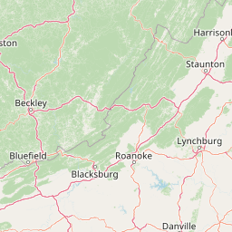
Map view of Rough Mountain Wilderness

Use this park location map to pinpoint Rough Mountain Wilderness in United States of America, understand its exact geographic position, and read its mapped placement within the surrounding landscape more clearly.

Pigeon | © OpenStreetMap contributors

Location context for Rough Mountain Wilderness

Alleghany CountyBath CountyVirginia
Recorded earthquake history

Explore Recorded Earthquake History Near Rough Mountain Wilderness

Access the historical seismic catalogue for the area surrounding Rough Mountain Wilderness to view recorded event magnitudes and epicentre distances. This database serves as a reference for historical activity within the Appalachian ridge and valley terrain.

Rough Mountain Wilderness Earthquake History

Catalogued events

2 events

Strongest magnitude

Magnitude 3.5

Most recent event

Apr 22, 1991

This history includes earthquakes recorded inside the park or within 50 km of its borders

Park atlas

Compare surrounding regional forests, rugged ridge terrain, and connected wilderness reserves

Explore Parks Near Rough Mountain Wilderness and Related Appalachian Protected Areas

Browse other protected areas near Rough Mountain Wilderness to examine neighboring Appalachian forest reserves and ridge terrain. Continuing into adjacent national forest lands provides broader geographic context for regional conservation systems.
Wildlife reserveVirginia
3.4 km away#1 closest

Southeast

Rich Hole Wilderness: Appalachian Wildlife Reserve and Forest Geography

Protected cove hardwood forest in western Virginia

Rich Hole Wilderness represents a protected high quality forest landscape located within the James River Ranger District. This area spans steep, narrow hollows and high ridge crests, providing critical habitat and showcasing old growth timber specimens. Use this resource to understand the park terrain, drainage patterns, and its position within the broader Appalachian forest network of western Virginia.

Area
26.1 km²
Established
1988
IUCN
Ib
Relief
Mountain
Watercolor painting showing layers of soft green hills and mountain ridges fading into a light hazy background.
Protected landscapeWest Virginia
25 km away#2 closest

North

Monongahela National Forest: Protected Appalachian Landscapes and Regional Geography

Mapping West Virginia wilderness and mountain terrain

Monongahela National Forest protects nearly one million acres of the central Appalachian Mountains. This massive federally managed landscape is defined by the Allegheny Front, the highest peak in the Allegheny range at Spruce Knob, and iconic geological formations like Seneca Rocks. The region represents a vital intersection of climate, hydrology, and biodiversity in the eastern United States, housing eight distinct wilderness areas and complex high-altitude ecosystems.

Area
3,727.8 km²
Established
1920
Visitors
3M annual
Relief
Mountain
A wide watercolor illustration showing rolling mountains in pastel shades of pink, purple, and green, with a line of trees and a reflective body of water in the foreground, framed by bare tree branches on the sides.
Protected areaVirginia
36 km away#3 closest

Southeast

James River Face Wilderness: Mapping the Topography of Virginia's Blue Ridge Protected Landscapes

Geographic overview of mountain wildlands and boulder fields

Spanning over 8,900 acres, James River Face Wilderness serves as a vital protected area within the Appalachian mountain chain. The landscape contains steep creek drainages, vertical ridgelines, and significant geological formations such as the Devils Marbleyard, offering a comprehensive study of central Virginia's complex forest ecosystems and rugged mountain terrain.

Area
36.05 km²
Established
1975
IUCN
Ib
Relief
Mountain
A soft watercolor illustration depicting a stream flowing through a forested valley with mountain ridgelines in the background.
Wildlife reserveUnited States of America
About 50 km away#4 closest

Northeast

Ramseys Draft Wilderness: Appalachian Ridge and Valley Protected Landscape and Map Atlas

Examining wilderness boundaries and mountain stream geography in Virginia

Located in western Virginia, Ramseys Draft Wilderness is a federal protected area characterized by its extreme vertical relief and rugged Appalachian topography. Spanning from the main crest of Shenandoah Mountain to the valley floor, this wilderness serves as a vital corridor for high-elevation forest ecosystems, native brook trout, and neotropical migrant birds.

Area
26.38 km²
Established
1984
Relief
Mountain
Climate
Temperate
Wildlife reserveNelson County
51 km away#5 closest

East

Priest Wilderness: A Deep Dive Into Appalachian Mountain Geography and Protected Forest Boundaries

High elevation ridge terrain in Nelson County, Virginia.

Priest Wilderness stands as a signature protected area in the Blue Ridge Mountains, defined by a dramatic 3,000 foot vertical gain and dense, mature hardwood forests. This documentation maps the rugged ridge and hollow topography that characterizes one of the most significant wilderness sections along the central Appalachian trail corridor.

Area
23.17 km²
Established
2000
IUCN
Ib
Relief
Mountain
Watercolor painting of rolling hills, trees, and a river in a scenic landscape
National parkVirginia
70 km away#6 closest

Northeast

Shenandoah National Park: National Park Protected Landscape and Geography

Mapped terrain and protected area context in Virginia.

Shenandoah National Park is a designated national park in Virginia, offering a rich exploration of its protected landscape and geographic features. This page provides detailed atlas-oriented information, focusing on the park's mapped boundaries and its role within the regional geography. Discover the natural terrain and spatial identity of this important US protected area, ideal for understanding park landscapes.

Area
811.176 km²
Established
1935
IUCN
II
Visitors
1.7M annual
Wildlife reserveVirginia
76 km away#7 closest

Southwest

Mountain Lake Wilderness: Protected Appalachian Geography and Mountain Landscapes

High-elevation wetlands and ridge-line geography in Virginia

Mountain Lake Wilderness protects a compact yet biologically diverse landscape where cool, moist conditions support rare mountain bogs and red spruce forests. This protected area along the Eastern Continental Divide features rocky outcrops like White Rocks and War Spur Overlook, providing panoramic views of the surrounding Ridge and Valley terrain within the Jefferson National Forest.

Area
44.66 km²
Established
1984
IUCN
Ib
Relief
Mountain
A wide, panoramic watercolor illustration showing a row of green trees, faint mountains in the background, and grass reeds in the foreground left against a white background.
Wildlife reserveWest Virginia
79 km away#8 closest

North

Laurel Fork South Wilderness: Protected Appalachian Highlands and Forested Terrain

High elevation forest and creek drainage geography

Laurel Fork South Wilderness features a dense, unbroken stretch of Appalachian forest within West Virginia. This protected landscape is defined by its deep narrow hollows and high ridgelines, representing a vital example of mid elevation mountain terrain and recovering forest ecosystems within the Monongahela National Forest.

Area
23.41 km²
Established
1983
IUCN
Ib
Relief
Mountain

Common questions about visiting, size, designation, and location context for Rough Mountain Wilderness

Rough Mountain Wilderness FAQs for park facts, access, geography, and protected area context

Find quick answers about Rough Mountain Wilderness, including protected-area facts, park geography, trail and visitor context, and how the park fits into its surrounding country and regional landscape.
MoriAtlas Explorer

Continue Your Protected Areas Search Across the Global Atlas

Deepen your exploration by continuing the structured search for national parks and protected areas worldwide. Utilize the comprehensive filtering capabilities to compare different conservation landscapes and refine your understanding of global park geography. Discover more about the distribution and characteristics of protected natural areas.

Global natural geography