

Mori Atlas logo
Nature reserveRüdigsdorfer Schweiz

Discover the geologic features, sinkholes, and dry valleys defining this rare German nature reserve.

Rüdigsdorfer Schweiz: Mapping the Protected Gypsum Karst Landscape of Northern Thuringia

(Naturschutzgebiet Rüdigsdorfer Schweiz)

Rüdigsdorfer Schweiz represents the last intact gypsum karst area within Thuringia, showcasing a distinctive topography of low summits and dissolution-formed sinkholes near the Harz mountains. This nature reserve preserves a complex mosaic of soluble bedrock features and habitats that reflect thousands of years of geological activity. Through this geographic atlas, observe how the delicate karst surface, including dry valleys and irregular ridges, forms a protected landscape of significant ecological value in central Germany.

gypsum karstkarst landscapehill landscapenature reservehabitat protection areabird protection area

Rüdigsdorfer Schweiz

Nature reserve

Park overview

Structured park overview, official facts, and landscape profile for Rüdigsdorfer Schweiz

Rüdigsdorfer Schweiz park facts, protected area profile, and essential visitor context

Review the core facts for Rüdigsdorfer Schweiz, including designation, size, terrain, visitor scale, habitats, and operating context in one park-focused overview.

About Rüdigsdorfer Schweiz

Rüdigsdorfer Schweiz is a karst-dominated hill landscape situated on the southern edge of the Harz in the German state of Thuringia, just northeast of the town of Nordhausen. Although its summits reach only modest elevations, with the Buchholzer Berg at about 350 meters as the highest point, the area is geologically distinctive because its underlying Permian Zechstein rocks are dominated by gypsum, a mineral that dissolves relatively easily in groundwater. Over long periods, this dissolution has carved the region into a network of sinkholes, dry valleys, caves, and subtle hill ridges that give the landscape an unusual character for central Germany.

The landscape belongs to a tradition of small, scenic German areas nicknamed "Schweizen," a term historically used for miniature, rugged-looking countryside. In this case, the scenic interest is not altitudinal but structural: visitors encounter a varied surface texture shaped by karst processes, with the villages of Rüdigsdorf and Petersdorf sitting within the gently westward-tilting terrain. The area is bordered by several small rivers, including the Zorge to the west and the Helme to the south, while a series of minor streams such as the Roßmannsbach rise within the landscape itself.

Ecologically, Rüdigsdorfer Schweiz is the most important surviving gypsum karst complex in Thuringia. Gypsum karst habitats support specialized plant communities and invertebrate faunas that depend on the unusual chemistry and microtopography of dissolving rock, and these habitats have been substantially reduced across central Europe by quarrying. The area therefore carries protective status at several levels, combining a national nature reserve designation with European habitat and bird protection frameworks that extend beyond the immediate reserve into the wider South Harz gypsum karst region.

The area's identity is also closely tied to the debate over future gypsum extraction. Roughly a third of the original natural landscape was removed by mining during the twentieth century, and a renewed push to expand quarrying in the mid-2000s met with sustained local resistance. This history gives Rüdigsdorfer Schweiz a conservation profile that mixes geological fragility, ecological rarity, and active civic engagement, while the path of the Karstwanderweg, a long-distance themed trail illustrating karst landforms, runs through the area and reinforces its role as a place where landscape and human awareness intersect.

Quick facts and research context for Rüdigsdorfer Schweiz

Rüdigsdorfer Schweiz is a hill landscape located in the southernmost foothills of the Harz in Thuringia, Germany, within the Landkreis Nordhausen around the villages of Rüdigsdorf and Petersdorf near Nordhausen. Its highest point is the Buchholzer Berg at roughly 350 meters above sea level, and its terrain belongs naturally to the South Harz Zechstein Belt, a region defined by soluble Permian gypsum and anhydrite deposits.

The area is Thuringia's last intact gypsum karst landscape and was designated a nature reserve in 1957, covering around 3 square kilometers of its core. Broader European recognition comes from an overlapping Fauna-Flora-Habitat site covering about 6.7 square kilometers and the multi-part Südharzer Gipskarst bird protection area of nearly 29 square kilometers, underscoring its regional importance for both karst habitats and birdlife.

Protection and recognition

Examine the official conservation framework and protected area records for Rüdigsdorfer Schweiz.

Rüdigsdorfer Schweiz Protection Status and Designated Area Record

Rüdigsdorfer Schweiz holds recorded protected area status governed by international database standards for conservation geography. Review the documented administrative records and baseline designation details maintained for this protected landscape.

Protection details

WDPA ID
165239
Park context

Deeper park guide and search-rich context for Rüdigsdorfer Schweiz

Rüdigsdorfer Schweiz history, landscape, wildlife, and travel context

Explore Rüdigsdorfer Schweiz through its history, landscape character, ecosystems, wildlife, conservation priorities, cultural context, and seasonal travel timing in a structured park guide built for atlas discovery and search intent.

Why Rüdigsdorfer Schweiz stands out

Rüdigsdorfer Schweiz is best known as Thuringia's last intact gypsum karst area, a landscape defined by the slow dissolution of soluble rock rather than by dramatic mountain elevation. Visitors and researchers associate the area with its dense concentration of karst surface forms, including sinkholes, small collapse features, and dry valleys, all set within a landscape of low, rounded hills rather than high peaks. The region is also recognized for the way it combines karst terrain with multiple layers of formal protection, from a state nature reserve to European habitat and bird protection designations. The combination of geological fragility, ecological value, and a long-running local effort to resist renewed gypsum mining gives the area a distinctive identity among Germany's many small landscapes called "Schweizen."
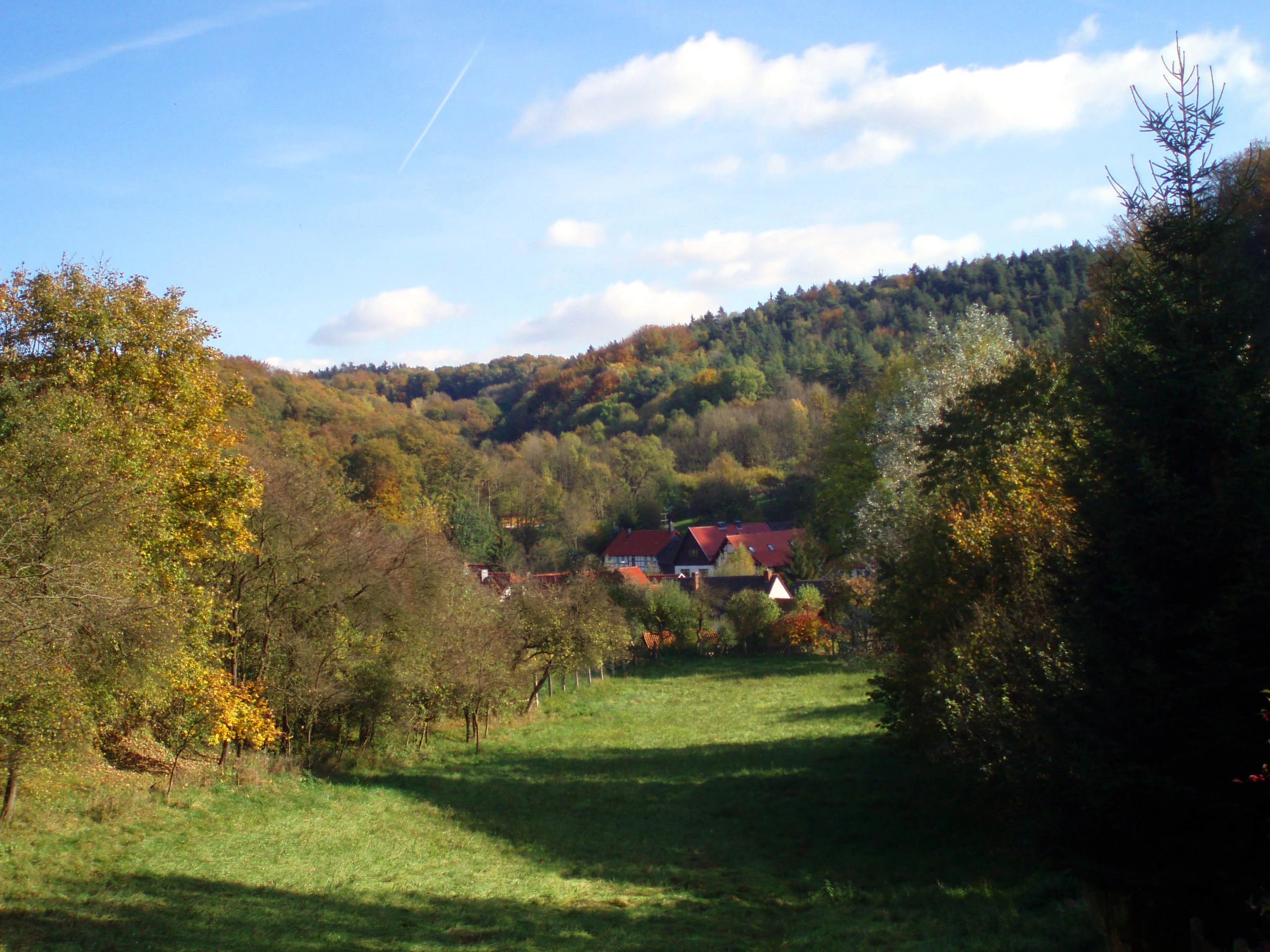
Rudigsdorfer Schweiz landscape
A view of the Rudigsdorfer Schweiz landscape, a protected natural area in Germany.

Rüdigsdorfer Schweiz history and protected-area timeline

The Rüdigsdorfer Schweiz has a conservation history that stretches back more than half a century. The core of the landscape was formally designated as a nature reserve in 1957, reflecting early recognition of the rarity and ecological value of Thuringia's gypsum karst terrain. Over the following decades, the area's significance grew as comparable karst landscapes elsewhere in the region were degraded by industrial activity or land-use change.

The twentieth century also brought serious losses: roughly one third of the original natural landscape was destroyed by gypsum quarrying. By the early 2000s, plans emerged to resume large-scale extraction within the surviving karst area, but local residents organized sustained opposition, and the proposals were blocked. Despite this success, the gypsum industry has continued to express interest in future mining, leaving the protection of the landscape an ongoing concern rather than a settled matter.

In addition to its natural history, the area played a small role during the First World War, when a Landwehr regiment was stationed in the Rüdigsdorfer Schweiz. While this military episode is a minor part of the area's overall story, it reflects the way the landscape, like many rural parts of Germany, became absorbed into wider events of the twentieth century before returning to its quieter identity as a protected natural area.

Rüdigsdorfer Schweiz landscape and geographic character

Physically, Rüdigsdorfer Schweiz is a gently rolling hill landscape rather than a mountain range. Its highest elevation, the Buchholzer Berg, reaches only about 350 meters above sea level, but the terrain has an unusually varied surface for such low ground. This is because the underlying geology belongs to the South Harz Zechstein Belt, where layers of Permian gypsum and anhydrite lie close to the surface and dissolve in groundwater, producing a textbook suite of gypsum karst landforms.

Among the most visible features are the numerous Erdfälle, or sinkholes, that pock the surface where underground cavities have collapsed. These features, combined with shallow dry valleys and subtle hill ridges shaped by differential dissolution, give the landscape a broken, irregular topography that contrasts with the smoother surrounding lowlands. The terrain tilts gently toward the west and southwest, so that drainage is broadly organized in that direction.

The area is surrounded and partly drained by a network of small rivers. To the west flows the Zorge, while to the south lies the Helme, and to the east runs the Krebsbach. Several smaller streams rise within the landscape itself, including the Roßmannsbach, the Orbach, and the Harzfeldgraben. The combination of low elevation, soluble bedrock, and active stream incision produces the characteristic gypsum karst scenery that makes the area distinctive within the broader Harz region.

Rüdigsdorfer Schweiz ecosystems, habitats, and plant life

Ecologically, Rüdigsdorfer Schweiz represents a rare and increasingly precious type of habitat in central Germany. Because soluble gypsum bedrock weathers in distinctive ways, gypsum karst supports plant and animal communities adapted to unusual soil chemistry, periodic surface disturbance from sinkhole collapse, and the dry, rocky microhabitats that develop around exposed gypsum outcrops. These conditions are uncommon elsewhere in Thuringia, which is why the surviving intact karst here is considered the state's last example of its kind.

Beyond its geological specialities, the area functions as part of a wider ecological network across the South Harz. Its protection designations are layered: the core nature reserve is complemented by a larger Fauna-Flora-Habitat site that stretches well beyond the immediate reserve into surrounding woodland, and by an extensive multi-part bird protection area covering nearly 29 square kilometers of the regional gypsum karst landscape. These overlapping designations reflect the area's importance not only for its specialist karst flora and fauna, but also for bird species associated with the broader mosaic of rocky slopes, dry grasslands, and forest patches that the South Harz supports.

The result is a landscape in which geological processes and ecological value are tightly intertwined. The same dissolution that creates sinkholes and dry valleys also sustains the microhabitats that many specialized species depend on, and protecting the surface means protecting the underground drainage system and the plant communities it sustains.

Rüdigsdorfer Schweiz wildlife and species highlights

The wildlife profile of Rüdigsdorfer Schweiz is shaped by the unusual combination of karst terrain, varied microhabitats, and extensive surrounding woodland. The area's inclusion in the larger Südharzer Gipskarst bird protection area indicates that the wider landscape is significant for birdlife, with the mosaic of rocky slopes, dry valleys, and forest patches providing breeding and feeding habitat for a range of species typical of the South Harz region.

Within the gypsum karst itself, the dry, sun-exposed rocky surfaces and the disturbance regimes created by sinkhole formation provide microhabitats for invertebrates and plant species that are unusual in this part of Germany. Although the area is too small to host large mammal populations on its own, it functions as an important element of a wider ecological corridor linking the southern Harz foothills with surrounding protected areas of the Landkreis Nordhausen, including reserves such as Harzfelder Holz and Sattelköpfe.

Rüdigsdorfer Schweiz conservation status and protection priorities

Conservation is central to the identity of Rüdigsdorfer Schweiz. The core of the landscape has been protected as the Naturschutzgebiet Rüdigsdorfer Schweiz since 1957, an unusually long-standing designation that reflects early awareness of the area's geological and ecological value. This national-level protection is reinforced by two significant European designations: a Fauna-Flora-Habitat site covering roughly 6.7 square kilometers, and inclusion in the seven-part Südharzer Gipskarst Special Protection Area, which spans close to 29 square kilometers of the broader regional karst landscape.

The international recognition of the area is rooted in the rarity of intact gypsum karst in Thuringia and, more broadly, in central Germany. Roughly a third of the natural landscape here was removed by gypsum quarrying during the twentieth century, and proposals to resume industrial extraction in the early 2000s galvanised local opposition. The campaign against renewed mining became a defining moment for the reserve and ensured that the area maintains a high public profile as an example of community-driven conservation. Although the gypsum industry retains an interest in future extraction, the layered protective status of the landscape provides a strong formal basis for its continued preservation, and the area's position along the Karstwanderweg helps connect its geological story with broader public engagement.

Rüdigsdorfer Schweiz cultural meaning and human context

The cultural identity of Rüdigsdorfer Schweiz is closely tied to the small villages that sit within and around it, particularly the Nordhausen districts of Rüdigsdorf and Petersdorf, which form the human heart of the landscape. Like many "Schweiz" areas in Germany, the name reflects a tradition of designating locally beloved scenery with an affectionate, alpine-sounding nickname, even when elevations are modest.

The area's twentieth-century history includes both industrial transformation and a moment of military use during the First World War, when a Landwehr regiment was stationed in the landscape. More recently, the community's organized resistance to renewed gypsum quarrying in the early 2000s has become an important part of the area's contemporary identity, linking local civic traditions with modern conservation activism.

Top sights and standout views in Rüdigsdorfer Schweiz

Rüdigsdorfer Schweiz offers a rare combination of compact scale and layered ecological significance, making it a distinctive destination for those interested in karst landscapes and conservation history. Its highest point, the Buchholzer Berg, offers gentle views across a surface dotted with sinkholes and dry valleys, while the area's protected status guarantees that the surrounding mosaic of rocky slopes, dry habitats, and woodland remains largely intact.

Key strengths include its role as Thuringia's last intact gypsum karst area, its long-running nature reserve designation, and its placement within larger European habitat and bird protection networks. The Karstwanderweg, which passes through the landscape, adds a thematic dimension, inviting visitors to read the surface of the area as the product of slow geological processes rather than dramatic mountain building.

Best time to visit Rüdigsdorfer Schweiz

As a low hill landscape in central Germany, Rüdigsdorfer Schweiz can be appreciated in any season, but spring and early summer tend to bring out the contrast between fresh vegetation on the slopes and the bare, pale surfaces of gypsum outcrops and sinkhole edges. Late spring is also a rewarding time for birdlife, given the area's inclusion in the broader Südharzer Gipskarst bird protection area.

Autumn offers a quieter atmosphere, when forest colours deepen across the surrounding woodland and the karst surface features stand out clearly under lower light. Winter can be cold and occasionally snowy, but the open hilltops and exposed gypsum slopes remain accessible in conditions typical of the southern Harz foothills, providing a stark but still legible view of the landscape's structure.

Monthly climate preview

Long-term representative temperature and precipitation averages recorded at Thuringia

Rüdigsdorfer Schweiz Climate Normals and Annual Temperature Rhythm

Representative coordinates track measured annual temperature and precipitation norms across twelve distinct monthly intervals. Devolving full monthly data records reveals complete temperature ranges and precipitation distributions for analytical comparison.
Annual mean8 °C
-1 °C18 °C
Jan-1°
Feb-1°
Mar
Apr
May12°
Jun15°
Jul18°
Aug18°
Sep13°
Oct
Nov
Dec
Warmest month
July

17.7 °C

Coolest month
January

-1.4 °C

Wettest month
July

2.8 mm/day

Driest month
April

1.5 mm/day

Park location guide

Geography guide, regional context, and park location map for Rüdigsdorfer Schweiz

Rüdigsdorfer Schweiz park geography, regions, and map view in Germany

Understand where Rüdigsdorfer Schweiz sits in Germany through a broader geographic reading of the surrounding landscape, nearby location context, and its mapped position within the national park landscape.

How Rüdigsdorfer Schweiz fits into Germany

Germany is a federal republic in Western and Central Europe with a population of over 83 million across sixteen constituent states. It is Europe's largest economy by nominal GDP and a major global exporter and importer. The capital is Berlin, and the country borders Denmark, Poland, Czech Republic, Austria, Switzerland, France, Luxembourg, Belgium, and the Netherlands.

Wider geography shaping Rüdigsdorfer Schweiz in Germany

Germany is located in Western and Central Europe, spanning 357,022 km². It borders Denmark to the north, Poland and the Czech Republic to the east, Austria and Switzerland to the south, and France, Luxembourg, Belgium, and the Netherlands to the west. The country has coastlines on the Baltic Sea and North Sea to the north, with the Alps located in the southern region.

Map view of Rüdigsdorfer Schweiz

Use this park location map to pinpoint Rüdigsdorfer Schweiz in Germany, understand its exact geographic position, and read its mapped placement within the surrounding landscape more clearly.

Pigeon | © OpenStreetMap contributors

Location context for Rüdigsdorfer Schweiz

Thuringia

Visual reference of rolling hill terrain, sinkholes, and protected habitats

Rüdigsdorfer Schweiz Photos, Landscape Scenery, and Gypsum Karst Views

Photographic records reveal the distinct gypsum karst topography, rolling hills, and rare dry valleys that define Rüdigsdorfer Schweiz. Visual observation clarifies how geological dissolution shapes the surface terrain and protected natural habitats across the region.

Rudigsdorfer Schweiz landscape

Park atlas

Compare adjacent terrain and regional conservation areas in the southern Harz foothills.

Parks Near Rüdigsdorfer Schweiz and Surrounding Protected Landscapes to Explore

Browse other parks near Rüdigsdorfer Schweiz to compare similar gypsum karst formations and low mountain fringe habitats. Expanding the search reveals connected protected landscapes across the surrounding region for deeper geographical study.
Nature reserveThuringia
About 5.9 km away#1 closest

East

Alter Stolberg Nature Reserve: Mapping the Karst Landscapes of the South Harz

A study of Zechstein geology and forested ridge geography in Thuringia

The Alter Stolberg serves as a primary example of karst topography within the South Harz Zechstein Belt, offering a compact and heavily wooded plateau landscape. This protected area includes distinct geological features like the Heimkehle gypsum cave and historical medieval ruins, illustrating the integration of natural processes and cultural history in central Germany. Explore the geographic boundaries and terrain characteristics that define this essential protected area.

Area
6.233 km²
Established
1961
IUCN
IV
Relief
Upland
Nature reserveThuringia
About 12 km away#2 closest

Northwest

Vogelherd Nature Reserve: Montane Beech Forest Landscape in Thuringia, Germany

Protected forest geography in the northern Harz mountains.

Vogelherd is a significant nature reserve located in the Harz mountains of Thuringia. It serves as a vital reference area for upper montane forest ecology, showcasing how acidic bedrock and high elevation shape the transition between beech and spruce woodland populations.

Area
0.151 km²
Established
1961
IUCN
IV
Nature reserveThuringia
About 16 km away#3 closest

Southwest

Wöbelsburg Nature Reserve: Protected Plateau Landscapes and Geography in Thuringia, Germany

Mapped shell limestone escarpment and Iron Age hillfort site.

Wöbelsburg offers a focused look at the rugged Muschelkalk terrain characteristic of the northwestern Hainleite. As a protected nature reserve, the site features a prominent mountain spur that drops steeply toward the Wipper lowland, providing a clear example of geological undercutting and plateau formation in central Germany.

Area
0.659 km²
Established
1961
Relief
Upland
Water
Minor water
Nature reserveThuringia
About 18 km away#4 closest

Southwest

Westliche Hainleite Nature Reserve: Mapping the Protected Ridgeline Landscapes of Northern Thuringia

A study of forest escarpments, erosional valleys, and Natura 2000 ecological connectivity

Westliche Hainleite is a protected nature reserve in Thuringia defined by its steep ridgeline escarpments and transitionary geography between the Hainleite range and the Dün hills. This area preserves a mosaic of woodland, cliff, and slope habitats, maintaining essential ecological continuity across the northern German hill country. Its topography is characterized by deep erosional gullies and named summits like Der Berg, which create a distinctive vertical profile within the regional landscape.

Area
9.459 km²
Established
2004
IUCN
IV
Protected areaThuringia
About 20 km away#5 closest

Southwest

Bleicheröder Berge: Geographic Profile and Protected Landscape Context in Thuringia

Mapping the forested ridges and Muschelkalk geology of the Thuringian region.

Investigate the Bleicheröder Berge as a vital protected area in Thuringia. This resource outlines the range's formation as a series of isolated hill remnants, its fossil-bearing limestone cliffs, and the botanical diversity characterizing its beech forests and rare orchid populations.

Area
16 km²
Relief
Mountain
Climate
Temperate
Access
Easy access
Nature reserveThuringia
About 21 km away#6 closest

West

Sülzensee, Mackenröder Wald: A Detailed Look at Thuringia's Protected Nature Reserve

Exploring the beech forest landscapes and stream-carved terrain of northern Thuringia.

Sülzensee, Mackenröder Wald is a protected nature reserve in northern Thuringia known for its expansive beech forests and diverse geological foundation. Spanning over 280 hectares, the area features undulating ridges, deep-cut stream valleys, and a unique position atop the Elbe-Weser watershed. This geography-focused overview details the reserve's status as a corridor for wildlife and its significant role in regional habitat conservation.

Area
2.802 km²
Established
2000
IUCN
IV
Watercolor illustration of a mountainous landscape with forests and a winding path
National parkLower Saxony
About 23 km away#7 closest

Northwest

Harz National Park: A Mapped Protected Landscape in Lower Saxony's Mountains

Explore geographic boundaries and regional terrain.

Harz National Park is a protected area defined by its unique mountain landscape and extensive forests in Lower Saxony, Germany. This MoriAtlas entry details its geographic scope, allowing for exploration of its mapped boundaries and its place within the regional geography. Understand the terrain, from its highest peaks to its alpine bogs, offering a structured view of this significant protected landscape for atlas-based discovery.

Area
247 km²
Established
2006
IUCN
II
Visitors
4M annual
Protected landscapeThuringia
About 25 km away#8 closest

Southeast

Naturpark Kyffhäuser: Protected Landscape and Regional Geography in Thuringia

Explore ridges, gypsum karst, and wetland migration sites.

Naturpark Kyffhäuser stands as a unique protected landscape in Thuringia, bridging the gap between dramatic gypsum massifs and expansive agricultural lowlands. Its geography includes the notable Hainleite and Windleite ridges, alongside diverse habitats ranging from dry steppe slopes to the internationally recognized Kelbra reservoir. This detailed view examines the topographical and ecological features that define the park within the Unstrut catchment area.

Area
305 km²
Relief
Upland
Climate
Temperate
Access
Access unknown

Common questions about visiting, size, designation, and location context for Rüdigsdorfer Schweiz

Rüdigsdorfer Schweiz FAQs for park facts, access, geography, and protected area context

Find quick answers about Rüdigsdorfer Schweiz, including protected-area facts, park geography, trail and visitor context, and how the park fits into its surrounding country and regional landscape.
MoriAtlas Explorer

Continue Your Protected Areas Search Across the Global Atlas

Deepen your exploration by continuing the structured search for national parks and protected areas worldwide. Utilize the comprehensive filtering capabilities to compare different conservation landscapes and refine your understanding of global park geography. Discover more about the distribution and characteristics of protected natural areas.

Global natural geography