Mori Atlas logo
State or regional parkSan Patricio State Forest

Mapping the secondary subtropical moist forest and surviving mogote terrain of Puerto Rico

San Patricio State Forest: A Protected Karst Landmark within San Juan Metropolitan Geography

San Patricio State Forest serves as a vital protected area within the dense urban fabric of San Juan, Puerto Rico. This site preserves a significant portion of the Northern Karst belt, featuring a rare surviving mogote that anchors the local landscape. Visitors and researchers can examine the intersection of secondary subtropical moist forest, restored native vegetation, and urban conservation efforts within this distinct tropical lowland ecosystem.

urban forestkarst landscapemogotesubtropical moist forestsecondary forestprotected urban green space

San Patricio State Forest

State or regional park

Park overview

Structured park overview, official facts, and landscape profile for San Patricio State Forest

San Patricio State Forest park facts, protected area profile, and essential visitor context

Review the core facts for San Patricio State Forest, including designation, size, terrain, visitor scale, habitats, and operating context in one park-focused overview.

About San Patricio State Forest

San Patricio State Forest is a compact, legally protected forest enclave inside the urban fabric of San Juan, Puerto Rico. It belongs to the island's public forest system, which consists of twenty state forests managed by the Puerto Rico Department of Natural and Environmental Resources. With an area of about 70 cuerdas, roughly 68 acres, it is the smallest protected area in that system, yet it carries a significance far beyond its size because of where it sits, what it preserves, and how it came into being.

The forest occupies part of the Gobernador Piñero district of San Juan, between the neighborhoods of Villa Borinquen, Caparra Heights, and the Borinquen Towers complex. Public access is available from Roosevelt Avenue and Ensenada Street, and the urban setting is one of its defining characteristics. Rather than being a remote wilderness reserve, San Patricio is a working city forest with visitor infrastructure, an information center, parking, accessible facilities, picnic gazebos, a plant nursery, and a network of interpretative trails. It is open to the public by appointment, free of admission, and serves as a venue for environmental education, research activities, and community events.

Ecologically, San Patricio is a second-growth subtropical moist forest, meaning its current tree cover has developed on land that was previously cleared and used for different purposes. Because of that history, much of the vegetation is of exotic origin, including ornamental and pioneer species typical of disturbed Caribbean lowlands. The higher and rockier ground, particularly around the surviving mogote, retains a more native character and has been used as a refuge for endangered Puerto Rican species that have been intentionally introduced into the forest for conservation. Geologically, the site belongs to the Northern Karst belt of northern Puerto Rico, with underlying alluvial clays, calcarenite, fossil-rich limestone of the Cibao Formation, and chalky deposits typical of the region.

The broader significance of San Patricio lies in the story of how an abandoned urban tract was restored, claimed, and legally restored to natural cover. The land was once a farm known as Finca San Patricio, was later taken over by the U.S. Army, briefly used for housing during the mid-twentieth century, and then left vacant as the city expanded around it. In 1998, environmental advocates and residents pushed for formal protection, and in August 2000 the forest was proclaimed by executive order and assigned to the DRNA for recreation and scientific research. After Hurricane Maria in 2017 forced a temporary closure, the site was revitalized and reopened in April 2021, continuing its role as a living piece of green infrastructure inside one of the Caribbean's most densely populated metropolitan areas.

Quick facts and research context for San Patricio State Forest

San Patricio State Forest is a roughly 70-acre second-growth subtropical moist forest located inside the city of San Juan, Puerto Rico, and is the smallest unit in the Puerto Rico state forest system. It is administered by the Puerto Rico Department of Natural and Environmental Resources (DRNA) and is classified within the Puerto Rican moist forests ecoregion as defined by the World Wildlife Fund.

The forest sits within the Northern Karst geological province of Puerto Rico, where its terrain includes alluvial fan deposits, calcarenite and chalky limestones, and exposures of the fossil-rich Cibao Formation. Its most recognizable feature is a single surviving mogote on the northern edge, originally one of three karst hills on the site, that is visible from many parts of San Juan and Guaynabo and supports a native plant community unusual for an otherwise secondary-growth urban forest.

Protection and recognition

Documented terrestrial protection history and conservation framework

San Patricio State Forest Protection Status and Designated Year

San Patricio State Forest holds established terrestrial protection status dating from the year 2000. Verified administrative records outline the formal designation history and management scope governing the protected landscape.

Protection details

Protection scope
Terrestrial
Designated year
2000
Transboundary protection
No
Park context

Deeper park guide and search-rich context for San Patricio State Forest

San Patricio State Forest history, landscape, wildlife, and travel context

Explore San Patricio State Forest through its history, landscape character, ecosystems, wildlife, conservation priorities, cultural context, and seasonal travel timing in a structured park guide built for atlas discovery and search intent.

Why San Patricio State Forest stands out

San Patricio State Forest is best known for its striking survival as an urban forest in the middle of San Juan, anchored by a single mogote, a steep residual limestone hill characteristic of Puerto Rico's Northern Karst, that still rises above the surrounding neighborhoods. The forest's identity is shaped by the contrast between a largely exotic secondary canopy of flamboyant, pink trumpet tree, and African tulip tree, and the pockets of native flora such as the endangered matabuey and Puerto Rican manac that have been reintroduced onto the rocky higher ground around the mogote. It is also widely recognized as a birdwatching site in the metropolitan area, hosting at least 33 bird species, including nine endemics such as the Puerto Rican bullfinch, Puerto Rican woodpecker, Puerto Rican oriole, Adelaide's warbler, and the green mango hummingbird. The combination of karst geology, reestablished forest cover, and easy public access makes it a small but distinctive natural area within Puerto Rico's capital region.
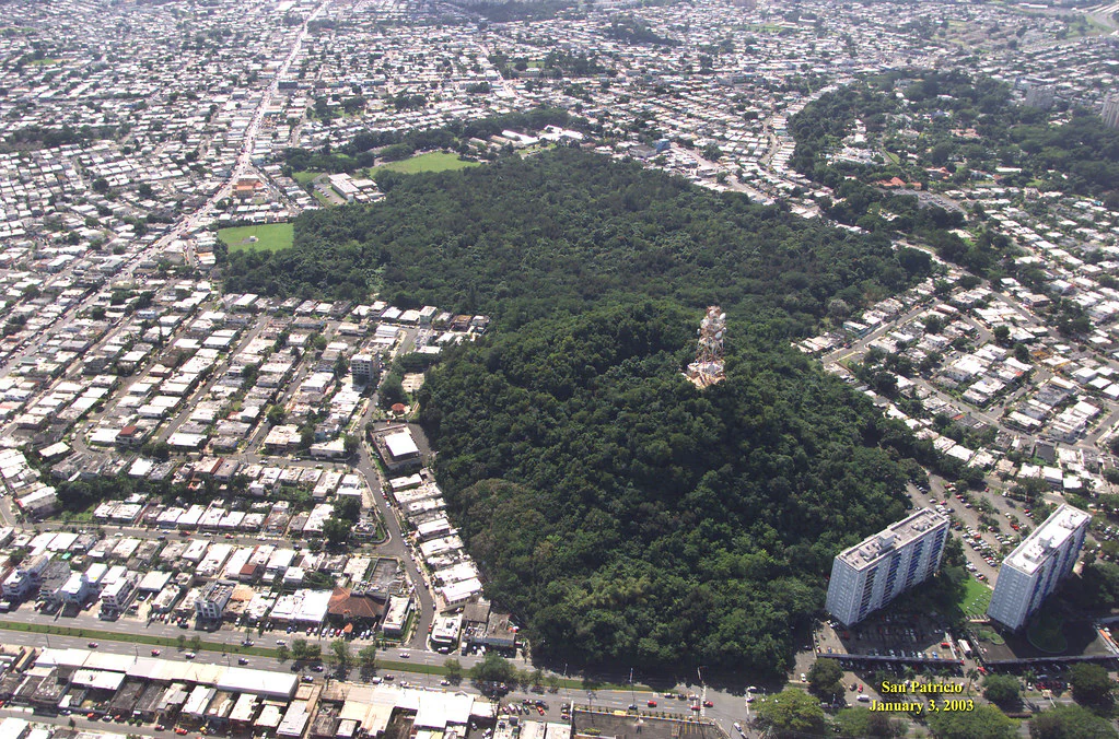
An aerial perspective of a dense green forest surrounded by a residential urban landscape in San Juan, featuring a prominent, elevated limestone hill.
An aerial view of San Patricio State Forest in San Juan, Puerto Rico, showing the protected urban forest and limestone hill.

San Patricio State Forest history and protected-area timeline

The land that is now San Patricio State Forest has a layered human history. Before becoming a forest, the property was a working farm known as Finca San Patricio, used for agriculture and cattle grazing on the northern edge of what would become greater San Juan. In the original landscape of the site, three mogotes, the characteristic steep-sided karst hills of Puerto Rico's Northern Karst, rose above the surrounding terrain. Two of those hills were quarried away to make room for the construction of the Villa Borinquen neighborhood and the Borinquen Towers residential complex, leaving only the third mogote, the one that today defines the skyline of the forest.

In the twentieth century, the remaining land was acquired by the U.S. Army with the intention of building additional housing for personnel at nearby Fort Buchanan. By 1960 the military withdrew and left behind a cluster of residences. As San Juan experienced rapid population growth and urban sprawl in 1962, much of the surrounding native forest was cleared for new development, and the area that would become San Patricio was similarly threatened. The only section that survived intact was the rough ground around the last remaining mogote, which was less practical to develop. Between 1974 and 1999, most of the abandoned army residences were demolished, leaving tracts of empty land that, over time, were slowly recolonized by trees and shrubs. The site was at that point owned by the governmental Corporation for Housing and Urban Development, or CRUV, today the Puerto Rico Department of Housing, which had planned social-interest housing that was never built.

By the late 1990s, the area was widely regarded as one of the last green zones left in San Juan. In 1998, a local environmental group called Ciudadanos Pro Bosque San Patricio, together with scientists and neighborhood residents, began campaigning for official protection of the land. Their efforts led, on August 3, 2000, to an executive order proclaiming the forest and assigning it to the Puerto Rico Department of Natural and Environmental Resources, or DRNA, for management, recreation, and scientific research. After Hurricane Maria caused severe damage in 2017, the forest was closed for repairs and revitalization, ultimately reopening to the public in April 2021.

San Patricio State Forest landscape and geographic character

San Patricio State Forest sits within the Northern Karst region of Puerto Rico, a belt of limestone terrain shaped by the dissolution of soluble rock and visible across many parts of the island's northern coast and interior. The forest's surface geology reflects this regional setting, with three principal geological units present: alluvial fan deposits made of red sandy and silty clays; water-deposited limestone composed of calcarenite and chalky limestone rock; and exposures of the Cibao Formation, a fossil-rich unit made up of chalk, soft limestone, and sandy clay.

The most visually distinctive feature of the forest, and the element that has come to define it in the urban skyline, is its surviving mogote. Mogotes are steep-sided residual hills that remain after the surrounding limestone has eroded away, and they are a signature landform of the Northern Karst. Originally there were three mogotes on the site, but two were quarried during mid-century urban construction. The lone remaining mogote on the northern edge of the forest still hosts a communications tower and acts as a visual landmark visible from many parts of San Juan and the neighboring municipality of Guaynabo. Today, this mogote and the rocky high ground around it provide the rough terrain on which the forest's native plant species are concentrated.

San Patricio State Forest ecosystems, habitats, and plant life

San Patricio is a second-growth subtropical moist forest, meaning that the current woody cover has developed on land that was previously cleared and used for other purposes, rather than being an untouched primary forest. The ecosystem falls within the Puerto Rican moist forests ecoregion as classified by the World Wildlife Fund, a regional category that reflects a humid tropical climate, warm temperatures year-round, and a tree cover dominated by broadleaf species adapted to seasonal rainfall patterns.

Because the forest grew back on disturbed land, much of its plant cover is of exotic origin, consisting of pioneer and ornamental species typical of secondary Caribbean lowlands. Flamboyant, pink trumpet tree, also called Puerto Rican oak, and the invasive African tulip tree are among the most common species in the canopy. In contrast, the rockier and higher portions of the forest, particularly those associated with the mogote and its ledges, support a more characteristically native flora. Endangered or threatened native species have been deliberately introduced to the forest for conservation, including the elegant goetzea, locally called matabuey, and the Puerto Rican manac, a palm species, both of which have successfully adapted to the site's conditions.

The forest hosts an estimated seventy species of trees in total. Beneath the canopy, the combination of red clay alluvial deposits, calcarenite, and highly fossiliferous Cibao Formation limestone gives rise to pockets of unusual microhabitat, supporting both exotic regrowth and relict native vegetation in close proximity. This combination of secondary forest maturation, native refugia on rocky terrain, and small-scale karst features makes San Patricio a useful site for studying how tropical urban forests recover and what role karst outcrops play in preserving native species in heavily developed landscapes.

San Patricio State Forest wildlife and species highlights

San Patricio State Forest is widely appreciated as a birdwatching site, with at least thirty-three bird species recorded on the property. Nine of those species are endemic to Puerto Rico and found nowhere else in the world, giving the small forest an outsized ornithological value. Among the endemics present are the Puerto Rican bullfinch, the Puerto Rican screech owl, the Puerto Rican woodpecker, the Puerto Rican oriole, the Puerto Rican flycatcher, the Puerto Rican spindalis, Adelaide's warbler, the Puerto Rican vireo, and the green mango hummingbird. The combination of secondary forest, karst terrain, native vegetation patches around the mogote, and a protected status that limits disturbance makes the site a reliable green-space refuge for these species inside San Juan.

The forest also supports a rich amphibian community. Three species of coqui frogs occur in the forest, including the common coqui, the whistling coqui, and the red-eyed coqui, locally known as churi. Other amphibians commonly encountered are the white-lipped frog and the cane toad. Reptiles are also well represented, with species such as the Puerto Rican racer, the Puerto Rican ground lizard, the crested anole, and the Puerto Rican anole living in the understory and on rocky surfaces. The Puerto Rican boa, an endangered snake endemic to the island, has also been documented within the forest.

The presence of the elegant goetzea and Puerto Rican manac among the plants, together with an endangered endemic boa among the reptiles, gives San Patricio a conservation profile that is unusually weighted toward rare native species for a forest of such small size and urban location.

San Patricio State Forest conservation status and protection priorities

San Patricio State Forest matters from a conservation perspective because it preserves a small but ecologically meaningful piece of native and recovering nature inside the densely populated metropolitan area of San Juan. The forest protects approximately seventy species of trees and a known thirty-three bird species, of which nine are Puerto Rican endemics, giving the site a biodiversity density that is significant for an urban protected area. It also shelters endangered native species that have been deliberately introduced for conservation, including the elegant goetzea and the Puerto Rican manac, and supports populations of the endangered Puerto Rican boa. By protecting these populations and the habitats they depend on, the forest functions as a refuge for species that have lost much of their natural range elsewhere on the island.

The conservation value of the site is amplified by its karst context. As part of the Northern Karst belt, San Patricio preserves outcrops and exposures of the fossil-rich Cibao Formation, calcarenite, and chalky limestone that support native plant communities unusual for an urban setting. The remaining mogote acts as a natural refugium where native species can persist in rocky terrain less affected by human alteration, while the surrounding secondary forest demonstrates how tropical woodlands can regenerate on abandoned urban land when given legal protection and time.

The official proclamation of the forest on August 3, 2000, by executive order and the transfer of management responsibility to the Puerto Rico Department of Natural and Environmental Resources formalized the conservation role of the site. Its stated purposes include recreation and scientific research, and the forest supports ongoing scientific studies of urban ecology, native species recovery, and tropical forest regeneration. After destruction caused by Hurricane Maria in 2017, the forest was closed and then actively revitalized before reopening in April 2021, reflecting an ongoing institutional commitment to maintaining this small but strategic protected area inside the capital region.

San Patricio State Forest cultural meaning and human context

San Patricio State Forest has a strong local identity tied to the urban communities that surround it. The forest is sometimes referred to as a bosque urbano, an urban forest, emphasizing its role as a green commons rather than a distant wilderness. It borders long-established San Juan neighborhoods such as Villa Borinquen, Caparra Heights, and the Borinquen Towers complex, and many of those communities have direct ties to the forest's recent history. It was residents and local environmental advocates from these neighborhoods, organized through the group Ciudadanos Pro Bosque San Patricio, who led the late-1990s campaign that ultimately produced the forest's legal protection in 2000.

The site also carries a layered memory of land use in mid-twentieth-century Puerto Rico. Before becoming a forest, it was a farm, then an army housing site, then an abandoned urban tract that residents watched slowly return to green. The decline of the original mogotes, two of which were destroyed to make room for housing developments, is part of the same cultural story of urban expansion that the surviving forest now stands against. Today, the forest is integrated into community life as a site for environmental events and educational programs, and it functions as a shared natural landmark visible from many parts of San Juan and Guaynabo, anchoring a sense of place for the surrounding city.

Top sights and standout views in San Patricio State Forest

The highlights of San Patricio State Forest center on the unlikely survival of a karst landscape inside one of the Caribbean's largest metropolitan areas, anchored by the lone remaining mogote that now serves as a recognizable green landmark on the San Juan skyline. The forest's seventy acres of second-growth subtropical moist forest support an estimated seventy tree species and at least thirty-three bird species, with nine Puerto Rican endemics making the small site disproportionately valuable for urban birdwatching and conservation. Reintroductions of endangered native plants such as the elegant goetzea and the Puerto Rican manac, alongside the presence of the endangered Puerto Rican boa, reinforce the site's role as a refuge for species that have lost most of their natural habitat elsewhere on the island.

Best time to visit San Patricio State Forest

San Patricio State Forest sits in a humid tropical climate where temperatures are warm year-round and seasonal variation mostly comes from rainfall patterns rather than temperature swings. The cooler and drier months of the northern Caribbean, generally falling in the late winter and early spring, tend to offer more comfortable conditions for walking the forest's interpretative trails and for birdwatching, since bird activity is often easier to observe when the understory is less saturated and the trails are in good condition.

The late summer and early fall bring the highest risk of tropical storms and hurricanes, a reality made clear by the damage Hurricane Maria inflicted on the forest in 2017 and the multi-year closure and revitalization that followed. Because of this, visits during the peak of hurricane season carry more uncertainty. For most visitors, the calmer and drier season will provide the most reliable experience, while recognizing that the forest itself remains ecologically active throughout the year thanks to its subtropical setting and the variety of bird and amphibian life it supports.
Monthly climate preview

Long term average temperature and monthly precipitation rhythm for San Patricio State Forest

San Patricio State Forest Climate Normals and Annual Temperature Patterns

Representative coordinate records show average monthly temperatures ranging from twenty five to twenty eight degrees Celsius alongside varying daily precipitation rates throughout the year. Examining the full twelve month climate profile reveals complete monthly averages and detailed precipitation normals for San Patricio State Forest.
Annual mean27 °C
25 °C28 °C
Jan25°
Feb25°
Mar25°
Apr26°
May27°
Jun27°
Jul28°
Aug28°
Sep28°
Oct27°
Nov26°
Dec25°
Warmest month
August

27.9 °C

Coolest month
January

24.9 °C

Wettest month
September

6 mm/day

Driest month
February

2.3 mm/day

Park location guide

Geography guide, regional context, and park location map for San Patricio State Forest

San Patricio State Forest park geography, regions, and map view in Puerto Rico

Understand where San Patricio State Forest sits in Puerto Rico through a broader geographic reading of the surrounding landscape, nearby location context, and its mapped position within the national park landscape.

How San Patricio State Forest fits into Puerto Rico

Puerto Rico is a Caribbean archipelago and island territory of the United States, classified as an unincorporated and organized territory under commonwealth status. Located in the North Atlantic Ocean east of the Dominican Republic, it serves as a significant cultural and economic hub in the region. The territory maintains its own constitution, governor, and legislative assembly while being represented in Congress by a resident commissioner.

Wider geography shaping San Patricio State Forest in Puerto Rico

Puerto Rico is a Caribbean island archipelago located in the North Atlantic Ocean, approximately 1,600 kilometers southeast of Florida. The main island spans about 177 kilometers in length and 65 kilometers in width, with a total land area of approximately 8,868 km². The terrain ranges from coastal plains to mountainous interior regions, with the highest point at Cerro Punta reaching 1,338 meters. The island is bordered by the Atlantic Ocean and Caribbean Sea.

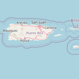
Map view of San Patricio State Forest

Use this park location map to pinpoint San Patricio State Forest in Puerto Rico, understand its exact geographic position, and read its mapped placement within the surrounding landscape more clearly.

Pigeon | © OpenStreetMap contributors

Visual reference of limestone mogotes, native habitats, and urban forest terrain

San Patricio State Forest Photos, Karst Landscapes, and Scenery

San Patricio State Forest photos reveal the striking karst terrain, surviving limestone mogote, and secondary canopy sheltered within the capital. Visual documentation clarifies how protected native flora and urban wildlife inhabit the rugged limestone environment.

An aerial perspective of a dense green forest surrounded by a residential urban landscape in San Juan, featuring a prominent, elevated limestone hill.

Park atlas

Compare nearby regional reserves, tropical moist forests, and connected limestone landscapes

Explore Protected Areas and Parks Near San Patricio State Forest in Puerto Rico

Browsing parks near San Patricio State Forest reveals connected protected landscapes across the surrounding region, expanding the scope of local conservation geography. Evaluating adjacent natural reserves provides deeper context for urban forest ecology, regional karst geology, and native species distribution.
Watercolor painting of a coastal landscape with green hills, wetlands, and distant mountains in a soft palette.
State or regional parkLoíza
About 14 km away#1 closest

East

Piñones State Forest: Mapped Geography and Protected Coastal Terrain in Loíza, Puerto Rico

Coastal mangrove reserve and protected forestland

Piñones State Forest is a significant protected area on the northern coast of Puerto Rico. This reserve features a low-lying landscape defined by intricate mangrove systems, coastal dunes, and rare endemic plant populations. Its proximity to the San Juan metropolitan area provides an important ecological buffer, offering a unique opportunity to map and study the intersection of Caribbean coastal woodlands and protected natural boundaries.

Relief
Lowland
Climate
Tropical
Access
Easy access
Scope
Terrestrial
Watercolor painting of a tropical mountain landscape with lush vegetation and palm trees in the foreground and rolling hills in the background.
State or regional parkPuerto Rico
About 34 km away#2 closest

South

Carite State Forest: Volcanic Mountain Geography and Protected Watersheds in Puerto Rico

Mapping the Sierra de Cayey ecosystem and river headwaters.

Carite State Forest protects 2,600 hectares of rugged, volcanic mountain landscape in southeastern Puerto Rico. Known for its subtropical moist forest and high-elevation dwarf zones, the terrain provides a critical habitat for rare endemic species. The forest serves as a vital hydrological watershed, sustaining regional river systems through its complex network of ravines and forested mountain slopes.

Area
26 km²
Established
1935
Relief
Mountain
Climate
Tropical
State or regional parkPuerto Rico
About 50 km away#3 closest

East

Ceiba State Forest: Mapping the Coastal Wetlands and Reefs of Eastern Puerto Rico

Coastal mangrove ecosystems and protected wetland habitats

Ceiba State Forest represents a critical coastal protected area in Puerto Rico, known for its dense mangrove ecosystems and adjacent coral reef environments. The reserve provides a compact, interconnected study of tidal wetlands and sandy shorelines. Use this structured profile to examine the geographic characteristics and protected boundaries that define this important avian sanctuary and coastal zone.

Area
1.42 km²
Established
1979
IUCN
Ia
Relief
Lowland
State or regional parkPuerto Rico
About 52 km away#4 closest

Southwest

Los Tres Picachos State Forest: A Geographic Guide to Puerto Rico's Mountain Protected Areas

Cloud forests, volcanic terrain, and watershed protection

Los Tres Picachos State Forest encompasses a striking landscape in the Puerto Rican interior, marked by deep river valleys and its namesake triple peaks. This atlas feature provides insights into the forest's layered ecological zones and its role as a crucial hydrological anchor for the Toro Negro and Cialitos river systems within the Cordillera Central.

Established
1999
Relief
Mountain
Climate
Tropical
Access
Remote access
State or regional parkPuerto Rico
About 52 km away#5 closest

South

Aguirre State Forest: Protected Coastal and Mangrove Geography in Southern Puerto Rico

Explore the estuarine terrain and tidal salt pond boundaries.

Aguirre State Forest encompasses a protected coastal mosaic of mangrove forests and salt-tolerant vegetation across the southern coast of Puerto Rico. This record outlines the forest's role as a primary node in the Jobos Bay estuarine system, characterized by low lying tidal channels and hypersaline flats that provide habitat for diverse avian and marine species within its protected borders.

Area
9.68 km²
Established
1918
Relief
Lowland
Climate
Tropical
A wide watercolor illustration showing a forest scene with trees in the foreground, a winding path or river, and green hills in the background.
Nature reservePuerto Rico
About 53 km away#6 closest

West

Cambalache Forest Reserve: A Detailed Look at Northern Puerto Rico Karst Geography

Protected karst landscape and forest mosaic

Focusing on the rugged limestone mogotes that define the Northern Karst Belt, Cambalache Forest Reserve serves as a vital protected area for endemic flora and fauna. This record provides geographic context on its low-elevation forest structure, the ecological significance of its varied microclimates, and its role as a persistent research site since the mid-twentieth century.

Established
1943
Relief
Upland
Access
Easy access
Scope
Terrestrial
Watercolor painting of a hilly, green landscape featuring rolling mountains in the distance and vegetation in the foreground.
State or regional parkUnited States of America
About 63 km away#7 closest

Southwest

Cerrillos State Forest: Protected Subtropical Woodland and Reservoir Geography

Foothill landscapes and watershed features in Ponce, Puerto Rico

This protected area features a mix of tabonuco forest and water-based recreational terrain. Spanning the slopes of the Cordillera Central foothills, the forest encompasses the Cerrillos River and the man-made Lake Cerrillos reservoir, offering a distinct example of subtropical moist forest ecology within the United States commonwealth system.

Area
0.79 km²
Established
1996
Relief
Upland
Climate
Subtropical
State or regional parkUnited States of America
About 65 km away#8 closest

West

Río Abajo State Forest: Mapping the Karst Terrain and Protected Landscapes of Puerto Rico

Protected karst landscape and regional forest geography

Río Abajo State Forest serves as an essential example of Caribbean karst ecosystems, defined by its steep limestone mogotes, hidden ravines, and extensive sinkhole networks. Located in the northern karst belt of Puerto Rico, the forest provides deep insight into complex subterranean drainage patterns and serves as a primary hub for endangered species recovery within its uniquely broken, three-dimensional terrain.

Area
14.1 km²
Established
1943
Relief
Upland
Climate
Tropical

Common questions about visiting, size, designation, and location context for San Patricio State Forest

San Patricio State Forest FAQs for park facts, access, geography, and protected area context

Find quick answers about San Patricio State Forest, including protected-area facts, park geography, trail and visitor context, and how the park fits into its surrounding country and regional landscape.
MoriAtlas Explorer

Continue Your Protected Areas Search Across the Global Atlas

Deepen your exploration by continuing the structured search for national parks and protected areas worldwide. Utilize the comprehensive filtering capabilities to compare different conservation landscapes and refine your understanding of global park geography. Discover more about the distribution and characteristics of protected natural areas.

Global natural geography