
Mori Atlas logo
Nature reserveScheidelberger Woog

Understanding the hydrological landscape, river confluence, and protected peat-rich basin boundaries

Scheidelberger Woog Nature Reserve: A Protected Moorland Mosaic in Rhineland-Palatinate

(Naturschutzgebiet Scheidelberger Woog)

The Scheidelberger Woog nature reserve serves as a critical conservation site within the Kaiserslautern district of Rhineland-Palatinate, encompassing a unique mosaic of wet meadows, peat cuttings, and sedge marshes. Fed by the confluence of the Glan and Schwarzbach rivers, this lowland moor landscape offers a quiet, water-dominated terrain that preserves traditional wetland ecosystems and rare plant communities. The area remains a essential component of the western Palatinate moor network, characterized by its slow-moving waters and characteristic alder-birch woodland fringes.

wetlandmoornature reservepeatlandriver confluenceGlan
A flat-design digital illustration showing a winding river in the foreground, with trees and bushes along the banks, leading toward a tall waterfall flowing between large, rocky mountains under a stylized sun.

Scheidelberger Woog

Nature reserve

Park overview

Structured park overview, official facts, and landscape profile for Scheidelberger Woog

Scheidelberger Woog park facts, protected area profile, and essential visitor context

Review the core facts for Scheidelberger Woog, including designation, size, terrain, visitor scale, habitats, and operating context in one park-focused overview.

About Scheidelberger Woog

The Scheidelberger Woog is a nature reserve in the Landstuhler region of Rhineland-Palatinate, situated within the Kaiserslautern district. Established in 1987, its boundary runs across parts of Hütschenhausen and the neighbouring municipality of Bruchmühlbach-Miesau. With an area of around 232 hectares, it belongs to a group of protected sites that together conserve the lowland moor systems of the western Palatinate.

The reserve's central feature is a Woog, a term used in this part of Germany for a still or slow-moving body of water, through which both the Glan and the Schwarzbach flow. This hydrological meeting point shapes the character of the entire protected area. The surrounding lowland has been shaped by centuries of peat cutting and traditional wet grassland use, leaving behind a varied terrain of peat pits, marshy meadows, reed beds, tall sedge stands, ditches, ponds, small watercourses, and patches of alder and birch woodland.

The site's conservation value is strongly tied to this habitat mosaic. The mix of open water, reed-fringed banks, wet meadows, scrubby field margins, and damp woodland creates conditions for plant and animal communities that depend on undisturbed moist ground. The reserve's designation specifically aims to safeguard these habitats together with their associated rare plant species and the threatened fauna that depend on them, viewing the Woog and its surroundings as an interconnected ecological system rather than a collection of separate features.

In the wider regional context, the Scheidelberger Woog sits alongside other protected areas such as the Landstuhler Bruch, the Rodenbacher Bruch, and the Östliche Pfälzer Moorniederung. Together these sites form a chain of wetland reserves stretching across the Westpfälzer Moorniederung, safeguarding one of the most extensive areas of lowland moor habitat in Rhineland-Palatinate. This regional context reinforces the reserve's significance: while modest in size on its own, it contributes to a larger conservation network that protects the landscape's hydrology, its peat-forming processes, and its characteristic species assemblages.

Quick facts and research context for Scheidelberger Woog

Scheidelberger Woog is a designated nature reserve in the Kaiserslautern district of Rhineland-Palatinate, in southwestern Germany. It covers approximately 232 hectares across parts of the municipalities of Hütschenhausen and Bruchmühlbach-Miesau and has been protected since 1987.

The reserve protects a section of the West Palatinate moor lowland, centred on the still water of the Woog at the confluence of the Glan and the Schwarzbach. Its mosaic of peat cuttings, wet meadows, reed beds, ponds, and alder-birch woodland gives it strong significance for regional biodiversity conservation.

Protection and recognition

Examine documented terrestrial protection history and conservation scope.

Scheidelberger Woog Protection Status and International Recognition

Scheidelberger Woog maintains a documented terrestrial protection status within global conservation databases. Systematic records outline the management framework and associated designation details for this protected natural landscape.

Protection details

Protection scope
Terrestrial
Transboundary protection
No
WDPA ID
165376
Park context

Deeper park guide and search-rich context for Scheidelberger Woog

Scheidelberger Woog history, landscape, wildlife, and travel context

Explore Scheidelberger Woog through its history, landscape character, ecosystems, wildlife, conservation priorities, cultural context, and seasonal travel timing in a structured park guide built for atlas discovery and search intent.

Why Scheidelberger Woog stands out

Scheidelberger Woog is best known for its mosaic of lowland moor habitats and the still water where the Glan and Schwarzbach rivers meet. The reserve preserves a rich mixture of peat cuttings, reed and sedge communities, wet meadows, small ponds, and damp woodland that is increasingly rare in the western Palatinate. It is also recognised as part of the broader Westpfälzer Moorniederung, a network of protected moor lowland sites that together safeguard one of southwestern Germany's most distinctive wetland landscapes.
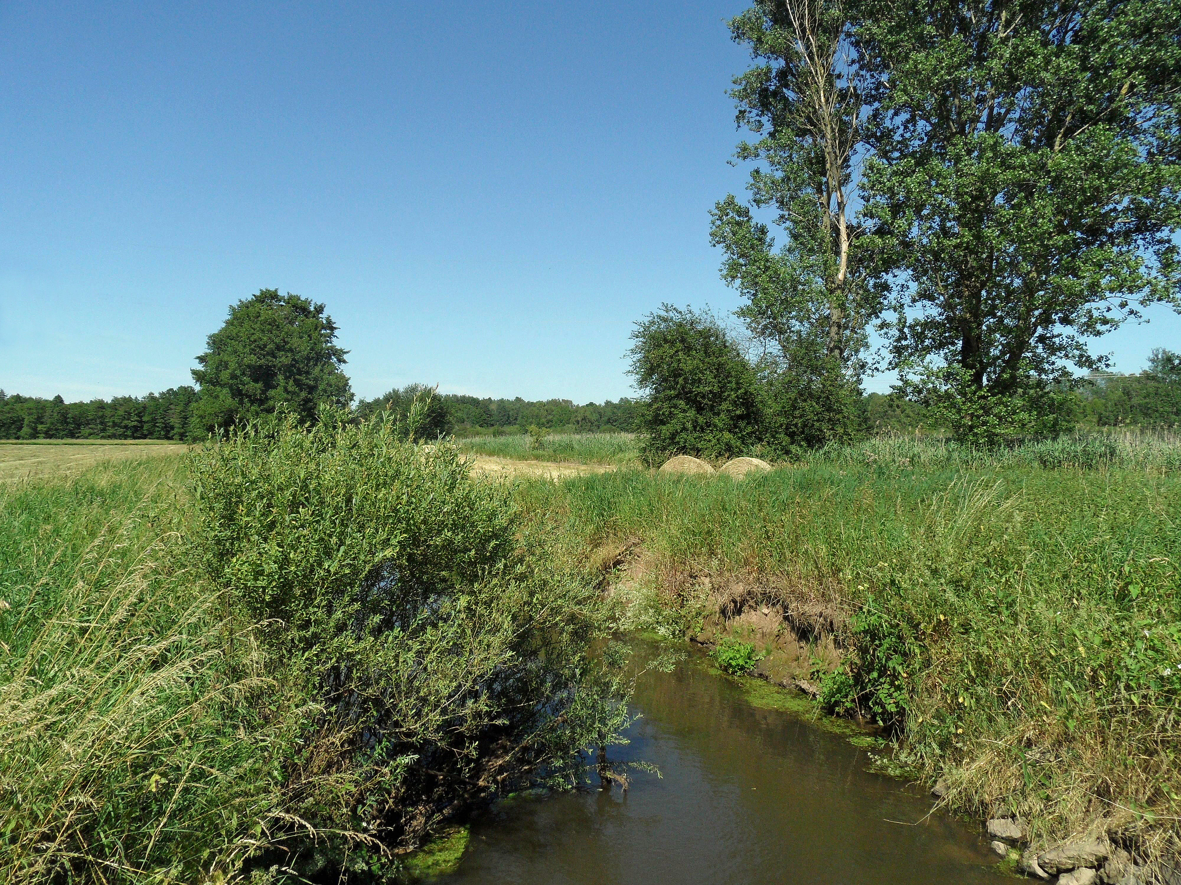
A small, calm stream flows through a lush, green wetland area surrounded by trees and grasses under a clear blue sky.
A view of the wetland landscape within the Scheidelberger Woog nature reserve.

Scheidelberger Woog history and protected-area timeline

The Scheidelberger Woog was formally protected as a nature reserve (Naturschutzgebiet) in 1987, with the designation recorded under the identifier 335091 in Rhineland-Palatinate's nature conservation registry. Its establishment was part of broader efforts in the region to safeguard the remaining fragments of the West Palatinate moor lowlands, which had been reduced and degraded by centuries of peat extraction, agricultural drainage, and land conversion.

The landscape itself, however, is far older than its protected status. The peat soils, wet meadows, and slow-moving water bodies of the area developed over long periods under the influence of the Glan and the Schwarzbach and their floodplain dynamics. Traditional land use, including peat cutting for domestic fuel, grazing on damp meadows, and limited reed and hay harvesting, helped shape the open, varied character of the habitat mosaic that the reserve now seeks to preserve.

By the late twentieth century, the ecological importance of these surviving fragments was increasingly recognised in West German conservation policy. The 1987 designation of the Scheidelberger Woog reflects this shift, locking in protection for an area whose value lies as much in its historical land-use pattern as in its underlying geology and hydrology.

Scheidelberger Woog landscape and geographic character

The landscape of the reserve is defined by a flat to gently undulating lowland basin shaped by the Glan and the Schwarzbach rivers. The hydrological heart is the Woog itself, a still or slow-moving water body at the junction of the two watercourses, whose fluctuating levels influence the surrounding ground conditions. The water's quiet surface, bordered by reed and sedge stands, gives the area a distinctly wetland character that sets it apart from the surrounding agricultural and forested Palatinate countryside.

Surrounding the Woog is a fine-grained mosaic of peat cuttings, wet and moist meadows, tall-sedge marshlands, reed beds, small ponds and pools, and a network of ditches, brooks, and natural water margins. Field margins and rough transitions between habitats add further structural variety. In places, wet woodland of alder and birch breaks up the open ground, while scattered grazing pastures continue the traditional open character of the landscape.

The overall impression is of a damp, open lowland shaped by both natural flooding patterns and long human use. Peat-rich soils and shallow groundwater create surfaces that feel soft and waterlogged for much of the year, and even drier patches retain the marks of old peat diggings. The terrain lacks dramatic relief, but its subtle variation of wet hollows, reed thickets, and quiet ponds gives the landscape its distinctive ecological texture.

Scheidelberger Woog ecosystems, habitats, and plant life

The Scheidelberger Woog protects a representative section of the West Palatinate moor lowland, one of the more important wetland complexes remaining in southwestern Germany. Its habitats include peat bogs and former peat cuttings, wet and moist grasslands, reed and sedge communities, ponds, ditches, slow-moving stretches of the Glan and the Schwarzbach, and patches of alder-birch wet woodland.

This mosaic is ecologically significant because it combines habitats at different stages of development and successional states, from open water and bare peat surfaces through reed beds and sedge marsh to damp woodland and grazed meadows. Such complexity supports a wide range of species that depend on specific moisture, vegetation structure, and water chemistry conditions.

The reserve also functions as part of a wider ecological network. Through its connections to neighbouring protected areas along the Glan and within the broader Pfälzer Moorniederung, it helps maintain ecological processes such as water flow, peat formation, and species dispersal across the regional wetland system. Its small size is offset by its integration into that larger landscape, giving individual species more room to move and populations more resilience against local disturbance.

Scheidelberger Woog wildlife and species highlights

While the source material does not list specific species, the habitat mosaic described in the nature reserve's designation text points to a community shaped by moisture, vegetation structure, and the transitional edges between open water, reed beds, marshland, and damp woodland. Such conditions in this part of the Palatinate typically support amphibian populations in ponds and ditches, waterbirds using the open water and reeds, and a range of wetland-dependent invertebrates in the sedge and reed stands.

The alder and birch woodland bordering the moister areas provides habitat for woodland and edge species, while the field margins and rough transitions between meadow and scrub add further structural diversity. The reserve's conservation rationale specifically emphasises rare and threatened fauna associated with these habitats, recognising that the ecological value of the site lies as much in its animal communities as in its plant life.

The wider moor lowland network of which the Scheidelberger Woog forms part is known in regional conservation planning as an important stronghold for wetland-associated wildlife in Rhineland-Palatinate, suggesting that the reserve plays a meaningful, if understated, role in maintaining populations at a regional scale.

Scheidelberger Woog conservation status and protection priorities

The reserve's conservation rationale centres on protecting the peat-forming wetland landscape of the western Palatinate moor lowlands as an interconnected system rather than as isolated features. The official designation text highlights the importance of the site's peat deposits, peat cuttings, wet and moist meadows, reed beds, sedge marshes, field margins, alder-birch woodland, grazing pastures, ponds, and watercourses as habitats for rare and threatened plant and animal species.

By buffering these habitats from agricultural intensification, drainage, and further peat extraction, the 1987 designation aimed to maintain the hydrology and soil conditions on which the entire habitat mosaic depends. Protection of the Woog itself, as a still water at the confluence of the Glan and the Schwarzbach, is central to this effort because it anchors the surrounding groundwater levels.

At a regional scale, the Scheidelberger Woog contributes to the conservation of the Westpfälzer Moorniederung, a network of lowland moor reserves including the Landstuhler Bruch and the Östliche Pfälzer Moorniederung. Together these sites maintain ecological connectivity and landscape-scale processes that no single reserve could preserve alone, giving the Scheidelberger Woog significance out of proportion to its modest individual area.

Scheidelberger Woog cultural meaning and human context

The cultural dimension of the Scheidelberger Woog lies in its long history of traditional land use. The peat-rich soils of the West Palatinate lowlands were historically worked for domestic fuel through small-scale peat cutting, a practice that left behind the fragmented pattern of peat pits, ditches, and pond-like depressions that still shape the reserve today.

Top sights and standout views in Scheidelberger Woog

The standout features of the Scheidelberger Woog are its quiet Woog at the confluence of the Glan and the Schwarzbach, the surrounding peat-cutting terrain, and the fine-grained mosaic of reed beds, sedge marsh, wet meadows, ponds, and alder-birch woodland. These elements together form one of the more characteristic surviving examples of the West Palatinate moor lowland.

Best time to visit Scheidelberger Woog

Given the reserve's wetland character, visits will generally be most rewarding in late spring and summer, when reed beds, sedge stands, and wet meadows are in active growth and water levels are typically at their most stable. In cooler months, the damp lowland atmosphere and open water can feel quieter and more subdued, while frost and mist often emphasise the still, low-lying nature of the landscape.

Monthly climate preview

Long-term representative point measurements tracking monthly averages across the protected terrain

Scheidelberger Woog Climate Normals, Annual Temperature and Precipitation Rhythm

Representative coordinate records show measured variations in average monthly temperature and precipitation for Scheidelberger Woog. Examining the complete twelve-month climatology profile provides deeper insight into long-term environmental patterns.
Annual mean9 °C
0 °C19 °C
Jan
Feb
Mar
Apr
May13°
Jun17°
Jul19°
Aug19°
Sep14°
Oct
Nov
Dec
Warmest month
July

19.2 °C

Coolest month
January

-0.2 °C

Wettest month
December

2.4 mm/day

Driest month
April

1.5 mm/day

Park location guide

Geography guide, regional context, and park location map for Scheidelberger Woog

Scheidelberger Woog park geography, regions, and map view in Germany

Understand where Scheidelberger Woog sits in Germany through a broader geographic reading of the surrounding landscape, nearby location context, and its mapped position within the national park landscape.

How Scheidelberger Woog fits into Germany

Germany is a federal republic in Western and Central Europe with a population of over 83 million across sixteen constituent states. It is Europe's largest economy by nominal GDP and a major global exporter and importer. The capital is Berlin, and the country borders Denmark, Poland, Czech Republic, Austria, Switzerland, France, Luxembourg, Belgium, and the Netherlands.

Wider geography shaping Scheidelberger Woog in Germany

Germany is located in Western and Central Europe, spanning 357,022 km². It borders Denmark to the north, Poland and the Czech Republic to the east, Austria and Switzerland to the south, and France, Luxembourg, Belgium, and the Netherlands to the west. The country has coastlines on the Baltic Sea and North Sea to the north, with the Alps located in the southern region.

Map view of Scheidelberger Woog

Use this park location map to pinpoint Scheidelberger Woog in Germany, understand its exact geographic position, and read its mapped placement within the surrounding landscape more clearly.

Pigeon | © OpenStreetMap contributors

Location context for Scheidelberger Woog

Rhineland-Palatinate

Visual reference collection showcasing local wetland habitats and river terrain

Scheidelberger Woog Photos, Scenery, and Protected Landscape Views

Visual documentation captures the flat lowland basin, quiet water bodies, and diverse moor habitats characteristic of Scheidelberger Woog. Photographic records provide clear insight into the complex mosaic of reed beds, damp meadows, and peat cuttings shaping the local protected environment.

A small, calm stream flows through a lush, green wetland area surrounded by trees and grasses under a clear blue sky.

Park atlas

Compare nearby wetland reserves, lowland moors, and connected regional conservation landscapes.

Exploring Other Parks Near Scheidelberger Woog and Surrounding Protected Areas

Browsing other protected areas near Scheidelberger Woog reveals related wetland habitats, river confluences, and peatland ecosystems across the western Palatinate. Expanding the geographic comparison helps place local conservation networks into a broader regional landscape context.
Nature reserveRhineland-Palatinate
Mapped location lies within the park boundary#1 closest

East

Westricher Moorniederung Nature Reserve: Protected Wetland and Moorland Atlas

Mapping low-lying basin landscapes and riparian corridors in the German Palatinate.

Spanning 40 kilometers between the Bliesaue and Kaiserslautern, the Westricher Moorniederung protects an intricate network of bogs, marsh zones, and alluvial forests. This lowland basin acts as a vital ecological link within Rhineland-Palatinate, defined by its drainage systems and diverse mire habitats. Gain insight into the regional geography and protected land boundaries that define this significant wetland system.

Area
21.52 km²
Established
1998
IUCN
IV
A minimalist watercolor illustration featuring a green treeline, soft rolling hills, and a calm body of water in warm light tones on a white background.
Protected landscapeRhineland-Palatinate
About 1 km away#2 closest

East

Landstuhler Bruch Protected Landscape: Regional Geography and Mapped Wetland Basin

Exploring the historic moorland basin of the Westpfalz

Situated in the Westpfalz region of Rhineland-Palatinate, the Landstuhler Bruch is a gentle lowland depression marked by a complex history of drainage and conservation. This protected area offers deep insight into the regional geology, preserved wetland pockets, and hydrological networks that define the local landscape. Understanding this basin provides a window into the intersection of cultural heritage and active ecological restoration in southwestern Germany.

Area
67 km²
Established
1985
IUCN
V
Relief
Lowland
A watercolor painting showing a green valley with a meandering river, low hills in the distance, and light pink clouds in the sky.
Nature reserveRhineland-Palatinate
About 2.1 km away#3 closest

Northwest

Glanniederung bei Elschbach: Protected River Floodplains and Wetland Geography

Nature reserve habitat and riparian landscape mapping

Spanning the Glan river valley in Rhineland-Palatinate, this nature reserve conserves a vital mosaic of wet meadows, reed beds, and near-natural stream courses. Gain insight into the regional conservation geography of this Palatinate habitat management area, where floodplain landforms define the ecological character of the protected valley floor.

Area
0.533 km²
Established
1987
IUCN
IV
Relief
Lowland
A soft watercolor painting of a wetland landscape with a gentle shoreline, grassy foreground, scattered trees, and distant hills under a pale sky.
Nature reserveRheinland-Pfalz
About 3.3 km away#4 closest

East

Schachenwald Nature Reserve: Geographic Overview and Protected Landscape Boundaries

Mapping the sand dunes and wetland terrain of Rheinland-Pfalz

Schachenwald functions as a vital nature reserve in the Kaiserslautern district, distinguished by its tightly knit combination of dry, sandy dune forests and damp alder swamp woodlands. The reserve highlights the complex interaction between weathered Buntsandstein ridge geology and bog-influenced lowlands, providing a clear window into the ecological diversity of the regional landscape.

Area
0.638 km²
Established
1987
IUCN
IV
Relief
Lowland
Nature reserveRheinland-Pfalz
About 4.5 km away#5 closest

Southwest

Neuwoogmoor Nature Reserve: Protected Peatland and Wetland Landscape Mapping in Rheinland-Pfalz

Essential geographic data on this historic Palatinate mire system.

Neuwoogmoor serves as a crucial nature reserve in Rheinland-Pfalz, protecting one of the few remaining peat moorland fragments in the Landstuhler Bruch. The site encompasses a diverse mosaic of bog pools, reed beds, and bog woodland that create an intimate and highly structured wetland terrain. This detailed entry provides geographic context on its protected status, hydrological features, and role as a habitat for rare plant communities in the western Palatinate landscape.

Area
0.6 km²
Established
1986
IUCN
IV
Relief
Lowland
A soft watercolor illustration depicting rolling green hills and meadows with subtle hints of pink flora, set against a pale background.
Nature reserveRhineland-Palatinate
About 13 km away#6 closest

South

Battweiler Höhe Nature Reserve: Mapped Protected Landscapes and Ridge Geography in Germany

A vital calcareous grassland habitat in the Zweibrücken hill country

Battweiler Höhe preserves a rare strip of semi-dry, lime-rich grassland on a gentle hill ridge in the Südwestpfalz district. This nature reserve in Rhineland-Palatinate exemplifies specialized habitat conservation, protecting a mosaic of meadows and forest edges that support uncommon plant species like pasqueflowers and orchids. The site is a significant link in the broader regional biotope network, maintaining its ecological health through traditional land management.

Area
0.244 km²
Established
2003
Nature reserveRheinland-Pfalz
About 15 km away#7 closest

East

Täler und Verlandungszone am Gelterswoog: Nature Reserve and Wetland Geography

A mosaic of lakes, mires, and stream valleys in Rheinland-Pfalz

Located in the Palatinate Forest, this protected nature reserve centers on the western shores of the Gelterswoog lake. It conserves a rare assembly of habitats including peat-forming moorland, reeds, and narrow forested valleys that provide essential breeding grounds for protected dragonfly species.

Area
0.554 km²
Established
1997
A soft, artistic watercolor painting showing a wide, tranquil wetland scene with soft green and yellow hues, distant rolling hills, and patches of trees and vegetation in a floodplain environment.
Protected landscapeSaarland
About 16 km away#8 closest

Southwest

Beeder Bruch Protected Landscape: Blies River Floodplain and Wetland Geography in Saarland

A managed riverine sanctuary in the Bliesgau Biosphere Reserve

Beeder Bruch is a formally recognized protected landscape in Saarland, defined by the extensive floodplain of the Blies river. The site integrates wet meadows, riparian forests, and reedbeds, serving as a key European bird protection zone. Visitors can explore the mapped terrain, which utilizes conservation grazing to maintain essential wetland habitats and support local biodiversity within the Bliesgau region.

Area
127 km²
Established
2015
IUCN
V

Common questions about visiting, size, designation, and location context for Scheidelberger Woog

Scheidelberger Woog FAQs for park facts, access, geography, and protected area context

Find quick answers about Scheidelberger Woog, including protected-area facts, park geography, trail and visitor context, and how the park fits into its surrounding country and regional landscape.
MoriAtlas Explorer

Continue Your Protected Areas Search Across the Global Atlas

Deepen your exploration by continuing the structured search for national parks and protected areas worldwide. Utilize the comprehensive filtering capabilities to compare different conservation landscapes and refine your understanding of global park geography. Discover more about the distribution and characteristics of protected natural areas.

Global natural geography