
Mori Atlas logo
Nature reserveSeußlitzer und Gauernitzer Gründe

Tracing the dry slopes, wooded brook ravines, and riverside terrain of this essential Saxon nature reserve.

Seußlitzer und Gauernitzer Gründe Nature Reserve: Mapped Protected Landscapes in the Sachsen Elbe Valley

(Naturschutzgebiet Seußlitzer und Gauernitzer Gründe)

Seußlitzer und Gauernitzer Gründe represents a significant mosaic of protected land situated along the Elbe River in Sachsen, Germany. This nature reserve comprises two distinct geographic parcels that safeguard steep sun-exposed slopes, deciduous woodland corridors, and sheltered brook ravines. Its landscape composition offers a vital look into the habitat connectivity of the Upper Elbe valley and the structured conservation of calcareous dry grasslands within the region.

nature reserveElbe valleydry grasslandscalcareous slopesdeciduous forestbrook valleys
A minimalist, flat-style vector illustration depicting a wide mountain valley with evergreen forests, a small waterfall, and a river flowing through the center under a light sky.

Seußlitzer und Gauernitzer Gründe

Nature reserve

Park overview

Structured park overview, official facts, and landscape profile for Seußlitzer und Gauernitzer Gründe

Seußlitzer und Gauernitzer Gründe park facts, protected area profile, and essential visitor context

Review the core facts for Seußlitzer und Gauernitzer Gründe, including designation, size, terrain, visitor scale, habitats, and operating context in one park-focused overview.

About Seußlitzer und Gauernitzer Gründe

Seußlitzer und Gauernitzer Gründe is a compact but ecologically rich nature reserve in the Elbe valley of Saxony, just upstream of the historic town of Meißen. Although it covers only a few hundred hectares, the reserve captures some of the most characteristic terrain of the Saxon Elbe valley: steep, often south-facing slopes dissected by narrow brook valleys, with patches of dry grassland interspersed among diverse deciduous forest.

The reserve consists of two distinct parcels. The Seußlitzer Gründe lie east of the village of Diesbar-Seußlitz on the right bank of the Elbe, forming part of the eastern Elbe hill landscape. Across the river, the Gauernitzer Gründe stretch between Gauernitz and Scharfenberg on the left bank, occupying left-Elbian stream valleys and slopes that descend toward the river.

By protecting both sides of the Elbe in this section, the reserve anchors a broader network of European protected sites. Its terrain overlaps with multiple Habitats Directive (FFH) and Birds Directive (SPA) zones that follow the Elbe corridor from Schöna to Mühlberg, as well as a series of left-Elbian stream valleys. This makes the reserve an important local component of larger cross-border conservation efforts along the Elbe.

Quick facts and research context for Seußlitzer und Gauernitzer Gründe

Seußlitzer und Gauernitzer Gründe is a designated Naturschutzgebiet in Saxony, with the official designation code D 02. The reserve spans around 357 hectares across two non-contiguous sites straddling the Elbe River in Landkreis Meißen. One section, the Seußlitzer Gründe, lies on the right bank of the Elbe east of Diesbar-Seußlitz, while the Gauernitzer Gründe section sits on the left bank between Gauernitz and Scharfenberg. Parts of both sections overlap with European Habitats Directive (FFH) sites and European Bird Directive (SPA) zones along the Elbe valley, placing the reserve within the larger Saxon Elbe protected-area network.

Protection and recognition

Review documented terrestrial protection scope and international recognition records.

Seußlitzer und Gauernitzer Gründe Protection Status and Governance

Seußlitzer und Gauernitzer Gründe holds recorded terrestrial protection status within the global database. Official records outline management scope and international recognition details where available.

Protection details

Protection scope
Terrestrial
Transboundary protection
No
WDPA ID
14532
Park context

Deeper park guide and search-rich context for Seußlitzer und Gauernitzer Gründe

Seußlitzer und Gauernitzer Gründe history, landscape, wildlife, and travel context

Explore Seußlitzer und Gauernitzer Gründe through its history, landscape character, ecosystems, wildlife, conservation priorities, cultural context, and seasonal travel timing in a structured park guide built for atlas discovery and search intent.

Why Seußlitzer und Gauernitzer Gründe stands out

The reserve is best known for protecting the steep Elbe slopes and small brook valleys west and east of Meißen, where dry grasslands, scrub, and varied deciduous woodland grow on sunny, often calcareous terrain. These slopes form a typical stretch of the Saxon Elbe hill landscape and contribute significantly to the habitat mosaic of the Upper Elbe valley. The combination of two separate parcels on opposite Elbe banks is also a defining feature of the protected area.
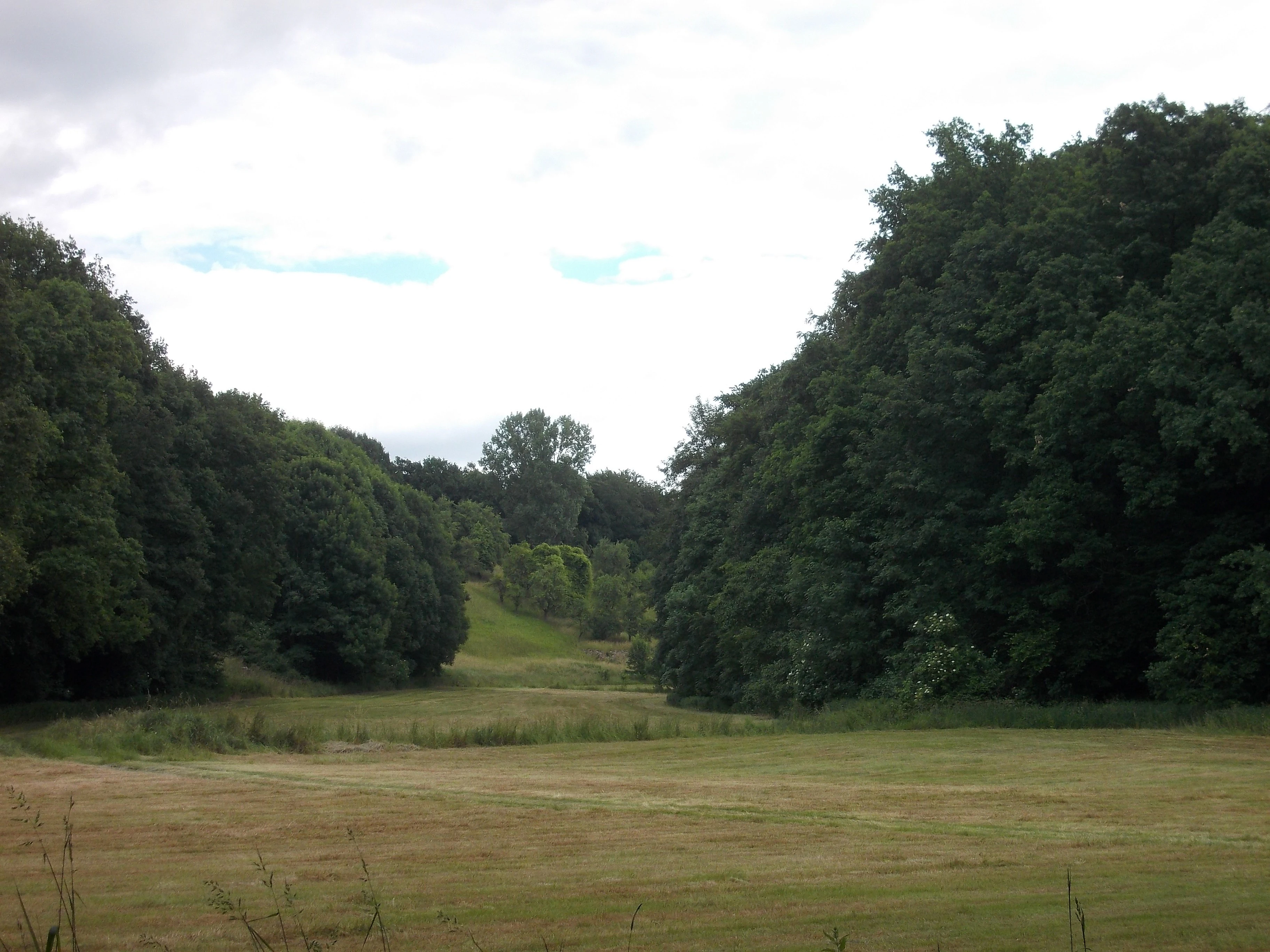
A wide view of a grassy meadow valley flanked by dense deciduous forests on both sides under an overcast sky.
A view of the Seußlitzer Grund, a valley within the Seußlitzer und Gauernitzer Gründe nature reserve in Saxony.

Seußlitzer und Gauernitzer Gründe history and protected-area timeline

Seußlitzer und Gauernitzer Gründe gained formal nature reserve status on 17 December 2013 through an ordinance issued by the Landratsamt Meißen, with the designation published in the Saxon Law Gazette in early 2014. The reserve was established as Naturschutzgebiet number D 02 in the Landkreis Meißen.

Its creation reflects a broader Saxon effort to consolidate protection of the Elbe valley landscape, where scattered parcels of dry grassland, deciduous forest, and Elbe-facing slopes had long held high ecological value. By joining the dry slopes and small valleys east of Diesbar-Seußlitz with the wooded stream valleys between Gauernitz and Scharfenberg under a single reserve designation, the regional authority brought a coherent piece of the Elbe valley under active habitat management rather than relying on the patchwork status of earlier protections.

Seußlitzer und Gauernitzer Gründe landscape and geographic character

The landscape of the Seußlitzer und Gauernitzer Gründe is shaped by the Elbe and the steep terrain that rises from its banks. On the right (north-eastern) side of the river, the Seußlitzer Gründe occupy an arm of the Elbe hill country east of Diesbar-Seußlitz, where slopes drop toward the river and small wooded valleys cut back into the surrounding plateau.

On the opposite, left bank, the Gauernitzer Gründe lie within a series of short stream valleys flowing down toward the Elbe between Gauernitz and Scharfenberg. These valleys, such as the Eichhörnchengrund near Gauernitz, combine narrow, shaded ravine bottoms with sunnier upper slopes, producing a strong contrast between cool, moist wooded corridors and drier, herb-rich slopes above.

Seußlitzer und Gauernitzer Gründe ecosystems, habitats, and plant life

The reserve protects a habitat mosaic typical of the Saxon Elbe valley. Sunny slopes support dry calcareous grassland, semi-dry meadow communities, thermophilic scrub, and scattered orchard-meadow transitions, while shaded ravine bottoms and valley flanks host structurally rich deciduous forest dominated by beech and oak. The narrow valleys among the Gauernitzer Gründe add small streams and moist deciduous woodland, increasing local habitat diversity within a compact area.

This alternation of hot, dry slopes and cool, shaded valleys creates favourable conditions for a wide range of plant and invertebrate communities within a small footprint. The ecological value of the reserve is closely tied to this fine-scale variation in slope, aspect, and moisture rather than to any single large habitat type.

Seußlitzer und Gauernitzer Gründe wildlife and species highlights

The structural diversity of the reserve, ranging from dry grassland and scrub on open slopes to mature deciduous forest in shaded valleys, supports a correspondingly varied fauna. Warm, herb-rich slopes and forest edges host insects associated with calcareous grassland habitats, while the wooded ravines and broader forest stands provide nesting habitat and shelter for woodland birds typical of the Saxon Elbe hill landscape.

Because the reserve lies within several European Birds Directive sites along the Elbe valley, it also contributes to the broader conservation of birdlife using the Elbe corridor as a migration and wintering route. Its location ensures that its wildlife interest extends beyond the steep slopes themselves into the wider floodplain and valley network.

Seußlitzer und Gauernitzer Gründe conservation status and protection priorities

The principal conservation importance of the Seußlitzer und Gauernitzer Gründe lies in its role as a protected refuge for the dry grassland and deciduous forest habitats of the Saxon Elbe valley. By bringing together two separate parcels on either side of the Elbe, the reserve helps maintain habitat continuity across the river corridor, a critical feature for populations of plants, invertebrates, and birds that depend on both slope and valley environments.

Much of the reserve overlaps with European Habitats Directive sites, including the large Elbe valley FFH area stretching from Schöna to Mühlberg, a dedicated Seußlitzer Gründe FFH site, and the left-Elbian stream valleys between Dresden and Meißen. The reserve also contributes to European Birds Directive zones covering the Elbtal between Schöna and Mühlberg, the Seußlitzer Elbhügelland und Golk area, and the left-Elbian brook valleys. This integration into the Natura 2000 network gives the reserve significance well beyond its modest size and places it within one of central Europe's most important riverine conservation landscapes.

Seußlitzer und Gauernitzer Gründe cultural meaning and human context

The reserve lies within a stretch of the Elbe valley long associated with wine-growing, small farming villages, and historic Saxon estates. Villages such as Diesbar-Seußlitz, Gauernitz, and Scharfenberg sit at the margins of the protected slopes, and traditional land uses including vineyards, orchards, and small-scale forestry have shaped the surrounding landscape for centuries. The resulting mosaic of villages, fields, and forested slopes gives the protected area a strong regional identity even though it is managed primarily for natural habitat conservation.

Top sights and standout views in Seußlitzer und Gauernitzer Gründe

The Seußlitzer and Gauernitzer parcels together protect two contrasting faces of the Saxon Elbe valley: a right-bank Elbe hillside landscape east of Diesbar-Seußlitz, and a system of left-bank brook ravines between Gauernitz and Scharfenberg. The reserve's inclusion in multiple Natura 2000 sites gives the local habitat patchwork a much larger conservation footprint along the Upper Elbe.

Best time to visit Seußlitzer und Gauernitzer Gründe

Late spring and early summer are typically the most rewarding times to experience the reserve, when dry-grassland slopes are in flower and woodland birds are active in the ravines. Autumn brings vivid leaf colour to the deciduous forest and soft light over the steep slopes above the Elbe. Cooler months offer quieter conditions and good visibility of the landscape structure, though winter weather can make the steep valley terrain more difficult to access on foot.

Monthly climate preview

Long term temperature and precipitation patterns across representative coordinates

Seußlitzer und Gauernitzer Gründe Climate and Monthly Weather Normals

Seußlitzer und Gauernitzer Gründe records measured monthly temperature ranges and precipitation rates derived from multi year station climatology. Examining the complete twelve month profile provides deeper insight into the long term weather averages established for this protected territory.
Annual mean9 °C
-1 °C19 °C
Jan-1°
Feb
Mar
Apr
May13°
Jun17°
Jul19°
Aug19°
Sep14°
Oct
Nov
Dec
Warmest month
July

18.9 °C

Coolest month
January

-1.4 °C

Wettest month
July

2.8 mm/day

Driest month
April

1.3 mm/day

Park location guide

Geography guide, regional context, and park location map for Seußlitzer und Gauernitzer Gründe

Seußlitzer und Gauernitzer Gründe park geography, regions, and map view in Germany

Understand where Seußlitzer und Gauernitzer Gründe sits in Germany through a broader geographic reading of the surrounding landscape, nearby location context, and its mapped position within the national park landscape.

How Seußlitzer und Gauernitzer Gründe fits into Germany

Germany is a federal republic in Western and Central Europe with a population of over 83 million across sixteen constituent states. It is Europe's largest economy by nominal GDP and a major global exporter and importer. The capital is Berlin, and the country borders Denmark, Poland, Czech Republic, Austria, Switzerland, France, Luxembourg, Belgium, and the Netherlands.

Wider geography shaping Seußlitzer und Gauernitzer Gründe in Germany

Germany is located in Western and Central Europe, spanning 357,022 km². It borders Denmark to the north, Poland and the Czech Republic to the east, Austria and Switzerland to the south, and France, Luxembourg, Belgium, and the Netherlands to the west. The country has coastlines on the Baltic Sea and North Sea to the north, with the Alps located in the southern region.

Map view of Seußlitzer und Gauernitzer Gründe

Use this park location map to pinpoint Seußlitzer und Gauernitzer Gründe in Germany, understand its exact geographic position, and read its mapped placement within the surrounding landscape more clearly.

Pigeon | © OpenStreetMap contributors

Location context for Seußlitzer und Gauernitzer Gründe

Sachsen

Photographic reference for steep Elbe slopes, dry calcareous grasslands, and wooded ravines.

Visual Exploration of Seußlitzer und Gauernitzer Gründe: Landscapes, Scenery, and Protected Habitats

Visual records capture the steep dry slopes, wooded brook valleys, and varied deciduous forest that define the terrain of Seußlitzer und Gauernitzer Gründe. Photographic observation reveals the distinct topography and habitat patchwork across both banks of the Upper Elbe valley.

A wide view of a grassy meadow valley flanked by dense deciduous forests on both sides under an overcast sky.

A dirt hiking path running alongside a narrow stream through a deciduous forest with sparse spring foliage.

Park atlas

Compare adjacent river valleys, hillside habitats, and regional protected landscapes

Explore Parks Near Seußlitzer und Gauernitzer Gründe and Surrounding Protected Areas

Browsing other parks near Seußlitzer und Gauernitzer Gründe reveals broader ecological patterns across the Upper Elbe valley. Analyzing surrounding protected areas provides essential regional context for the varied terrain and dry slope ecosystems of Saxony.
Nature reserveSachsen
About 4.5 km away#1 closest

Southeast

Winzerwiese und Gosebruch: Protected Nature Reserve and Valley Geography in Sachsen

Mapping protected wet meadows and floodplain woodlands

Winzerwiese und Gosebruch is a distinctive nature reserve in Sachsen, Germany, centered on a small valley along the Gosebach stream. This protected area creates a dense mosaic of wet meadow, marshy woodland, and dry deciduous forest, offering a significant look at the region's diverse botanical landscape and river-valley geography.

Area
0.116 km²
Established
1967
IUCN
IV
Nature reserveSaxony
About 9.5 km away#2 closest

Southwest

Trockenhänge südöstlich Lommatzsch: A Protected Dry-Slope Landscape in Saxony, Germany

Mapping rare grasslands and oak woodland habitats

Trockenhänge südöstlich Lommatzsch encompasses a unique network of non-contiguous parcels across the Ketzerbach valley. Formed on resilient Meißner monzonite bedrock, these sheltered slopes support threatened plant communities and high-value invertebrate habitats, standing as a critical protected fragment amidst the surrounding intensive agricultural landscape of Saxony.

A soft watercolor painting depicting a pale, hazy landscape with green grassy fields, light green trees, and distant faint mountains under a pastel sky.
Protected areaSaxony
About 15 km away#3 closest

North

Gohrischheide und Elbniederterrasse Zeithain: Geography and Protected Area Overview

Analyzing the inland dunes and dry heath landscape of the Elbe river terrace

Discover the unique geography of Gohrischheide und Elbniederterrasse Zeithain in Saxony, a protected area known for its expansive inland dunes and dry heath habitats. This region represents a rare combination of post-glacial sand landscapes and semi-open forest mosaics that reflect long-term ecological evolution and distinct regional environmental conditions.

Area
28.47 km²
Established
2011
Relief
Lowland
Climate
Temperate
A watercolor painting showing a calm pond with a small island of green trees and distant rolling hills under a soft pink and yellow sky.
Nature reserveMeißen District
About 19 km away#4 closest

East

Frauenteich Moritzburg: Mapping the Protected Wetland Landscapes of Meißen District

Glacial pond basins and diverse forest habitats in Saxony.

Frauenteich Moritzburg serves as a core component of Saxony's pond landscape, protecting a rich sequence of shoreline vegetation and open water. Its geography reflects the results of ancient glacial activity, creating a unique environment where sandy ridges and wet meadows coexist. This nature reserve provides essential refuge for bird populations, making it a focal point for understanding the natural, protected terrain within the broader Meißen District environment.

Area
2.02 km²
Established
1954
IUCN
IV
Relief
Lowland
A horizontal watercolor illustration showing a calm pond in the foreground, with lush green vegetation on the banks and rolling hills in the background under a soft sky.
Nature reserveMeißen
About 19 km away#5 closest

Southeast

Dippelsdorfer Teich Nature Reserve: Geographic Insights and Landscape Context

Historic Saxon pond management and regional protected landscape.

The Dippelsdorfer Teich serves as a primary example of historical pond construction and nature protection in the northern Dresden countryside. This 69 hectare reservoir captures a blend of ecological, cultural, and recreational values within the Meißen region. Users can examine its physical layout, the dam structure, and the integration of heritage transport within this managed lowland environment.

Area
0.69 km²
Established
1528
Relief
Lowland
Scope
Terrestrial
A horizontal watercolor painting showing a soft, atmospheric wetland scene with green meadows, tall grasses, distant tree lines, and a pale pink and yellow sky.
Nature reserveBrandenburg
About 21 km away#6 closest

North

Kleine Röder Nature Reserve: Mapped Wetland Geography and Protected Landscape in Brandenburg

A vital Elbe-Mulde lowland corridor near Bad Liebenwerda

The Kleine Röder Nature Reserve functions as a major ecological link in northeastern Germany, protecting a 385 hectare mosaic of fens, wet meadows, and alluvial forests. This site is defined by its water-dominated terrain and its role as a habitat corridor in the Elbe-Mulde lowland, encompassing both rare wetland flora and the historic Kosilenzien Slavic ringwall within its official boundaries.

Area
3.65 km²
Established
2011
IUCN
IV
Nature reserveSachsen
About 24 km away#7 closest

East

Waldmoore bei Großdittmannsdorf: A Protected Wetland Landscape in Sachsen, Germany

Mapping forest mires and rare swamp woodland habitats

Waldmoore bei Großdittmannsdorf represents a carefully maintained nature reserve in eastern Germany, spanning roughly 93 hectares of forest mire and bog structures. The site supports a rare transition of swamp woodland, sedge-rich wet stands, and spring flushes within the Laußnitzer Heide. As a designated Natura 2000 area, it plays a key role in safeguarding regional wetland connectivity and providing a refuge for specialist flora and fauna in the Saxon landscape.

Area
0.935 km²
Established
2000
IUCN
IV
Nature reserveFreistaat Sachsen
About 31 km away#8 closest

Southeast

Windberg Nature Reserve: Mapping the Forested Ridge and Protected Landscape of Saxony

Geology, mining heritage, and protected oak-beech forest ecosystems

Windberg serves as the prominent local landmark for Freital, defined by its elongated forested plateau and complex tectonic geography. This nature reserve offers a study in the intersection of environmental conservation and human industrial history, featuring Saxony's deepest cave and varied habitats within the eastern Ore Mountains foothills.

Established
1967
Relief
Mountain
Climate
Temperate
Access
Easy access

Common questions about visiting, size, designation, and location context for Seußlitzer und Gauernitzer Gründe

Seußlitzer und Gauernitzer Gründe FAQs for park facts, access, geography, and protected area context

Find quick answers about Seußlitzer und Gauernitzer Gründe, including protected-area facts, park geography, trail and visitor context, and how the park fits into its surrounding country and regional landscape.
MoriAtlas Explorer

Continue Your Protected Areas Search Across the Global Atlas

Deepen your exploration by continuing the structured search for national parks and protected areas worldwide. Utilize the comprehensive filtering capabilities to compare different conservation landscapes and refine your understanding of global park geography. Discover more about the distribution and characteristics of protected natural areas.

Global natural geography