
Mori Atlas logo
Protected areaGohrischheide und Elbniederterrasse Zeithain

Examining the ecological terrain, inland dunes, and protected habitat boundaries in eastern Saxony

Gohrischheide und Elbniederterrasse Zeithain Protected Area: Geography and Landscape Atlas

(Naturschutzgebiet Gohrischheide und Elbniederterrasse Zeithain)

Gohrischheide und Elbniederterrasse Zeithain represents a significant protected area located on the lower terrace of the River Elbe in Saxony. This territory spans diverse habitats including open sandy inland dunes, dry heaths, and pine forests that have been shaped by historical land use and recurring natural events. The site serves as a vital Natura 2000 protected landscape, offering a unique opportunity to study the intersection of regional geography, habitat conservation, and environmental dynamics in a semi-open steppe environment.

inland dunesdry heathlowland terracepine forestdry-warm semi-open landformer military training area
A flat-style digital illustration featuring a meadow with tall grasses, a line of coniferous and deciduous trees, and large jagged mountains in the background under a soft pastel sky, including a small waterfall on a mountain face.

Gohrischheide und Elbniederterrasse Zeithain

Protected area

Park overview

Structured park overview, official facts, and landscape profile for Gohrischheide und Elbniederterrasse Zeithain

Gohrischheide und Elbniederterrasse Zeithain park facts, protected area profile, and essential visitor context

Review the core facts for Gohrischheide und Elbniederterrasse Zeithain, including designation, size, terrain, visitor scale, habitats, and operating context in one park-focused overview.

About Gohrischheide und Elbniederterrasse Zeithain

Gohrischheide und Elbniederterrasse Zeithain is a notable protected landscape in the Landkreis Meißen in the Free State of Saxony, in eastern Germany. It lies within the Elbe lowland (Elbniederung), just a few kilometers north of the village of Zeithain and close to the border with the state of Brandenburg. The reserve spans parts of the municipalities of Zeithain and Wülknitz, as well as the Nauwalde area belonging to the town of Gröditz. To the north, across the state border, it adjoins the related Brandenburg protected area known as NSG Gohrische Heide, so the broader heath and dune complex in effect extends across both states.

The protected landscape covers about 2,847 hectares. Its core ecological value lies in a relatively large, open, dry habitat mosaic: inland dunes with open grasslands, dry heaths, and dry-warm semi-open land (Halboffenland), embedded within a wider pine-dominated forest matrix on the lower terrace of the Elbe. The site officially hosts Habitats Directive habitat types of community importance, especially inland dunes with open grasslands and dry heaths. A roughly 454-hectare special protection zone within the reserve is explicitly reserved for ecological succession and development.

The reserve is integrated into several overlapping layers of protection. It is simultaneously a Naturschutzgebiet under Saxony state law, an FFH area under the EU Habitats Directive, and a European Bird Protection Area. The IUCN management category assigned to it is Category IV, reflecting active habitat and species management. The forest district belongs to Staatsbetrieb Sachsenforst, and day-to-day nature reserve administration is shared with the Königsbrücker Heide.

For visitors, the landscape is partially accessible. In 2014, marked visitor trails were laid out in selected peripheral areas, and a six-meter-high wooden observation tower was built to allow limited viewing of the wider heath. Large parts of the interior, however, remain restricted because of persistent munitions contamination from the former Truppenübungsplatz Zeithain, a military training ground where the settlement of Gohrisch itself was abandoned in 1895. This combination of openness, ecological sensitivity, restricted access, and ongoing fire risk gives the reserve a distinctive and unusually layered identity.

Quick facts and research context for Gohrischheide und Elbniederterrasse Zeithain

Gohrischheide und Elbniederterrasse Zeithain is a Saxon nature reserve designated under the German Naturschutzgebiets status (NSG) and classified as an IUCN Category IV Habitat/Species Management Area. Its NSG identifier is D 95 and its World Database on Protected Areas entry is WDPA 318447. It was legally established on 11 January 2011 by ordinance of the Landratsamt Meißen. The reserve is part of the Natura 2000 network as both an FFH site (Nr. 4545-304) and a European Bird Protection Area (Nr. 4545-451), and contains Habitats Directive habitat types "inland dunes with open grasslands" and "dry heaths." The forest district is administered by Staatsbetrieb Sachsenforst, under the NSG administration of Königsbrücker Heide / Gohrischheide.

Protection and recognition

Documented terrestrial protection scope, international recognition sources, and conservation designation facts.

Gohrischheide und Elbniederterrasse Zeithain Protection Status and Natura 2000 Recognition

Gohrischheide und Elbniederterrasse Zeithain maintains a documented terrestrial protection scope backed by official Natura 2000 recognition sources. Detailed conservation designations and international administrative records provide a structured framework for this protected area.

International recognition

Protection details

Protection scope
Terrestrial
Transboundary protection
No
WDPA ID
318447
Core area
4.54 km²
Park context

Deeper park guide and search-rich context for Gohrischheide und Elbniederterrasse Zeithain

Gohrischheide und Elbniederterrasse Zeithain history, landscape, wildlife, and travel context

Explore Gohrischheide und Elbniederterrasse Zeithain through its history, landscape character, ecosystems, wildlife, conservation priorities, cultural context, and seasonal travel timing in a structured park guide built for atlas discovery and search intent.

Why Gohrischheide und Elbniederterrasse Zeithain stands out

The reserve is best known for its large inland dune and dry heath complex on the Elbe lowland terrace, a rare habitat combination in Saxony tightly linked to the former military training area at Zeithain. It is also notable for recurring, sometimes very large wildfires, which have repeatedly transformed the landscape and made it a focal point for fire management in the region. The combination of pale sandy soils, dry open habitats, inland dunes, pine forest, and protected Habitats Directive features gives the site a distinctive open, semi-steppe character unusual in central Europe. On top of this ecological profile, the area carries a strong cultural and infrastructural layer: a long period of military use, continuing munitions contamination in the soil, and therefore considerable constraints on access, monitoring, and rescue operations. Together, these traits make it a textbook example of how a former weapons range can become a place of high conservation value and, at the same time, of acute fire risk.
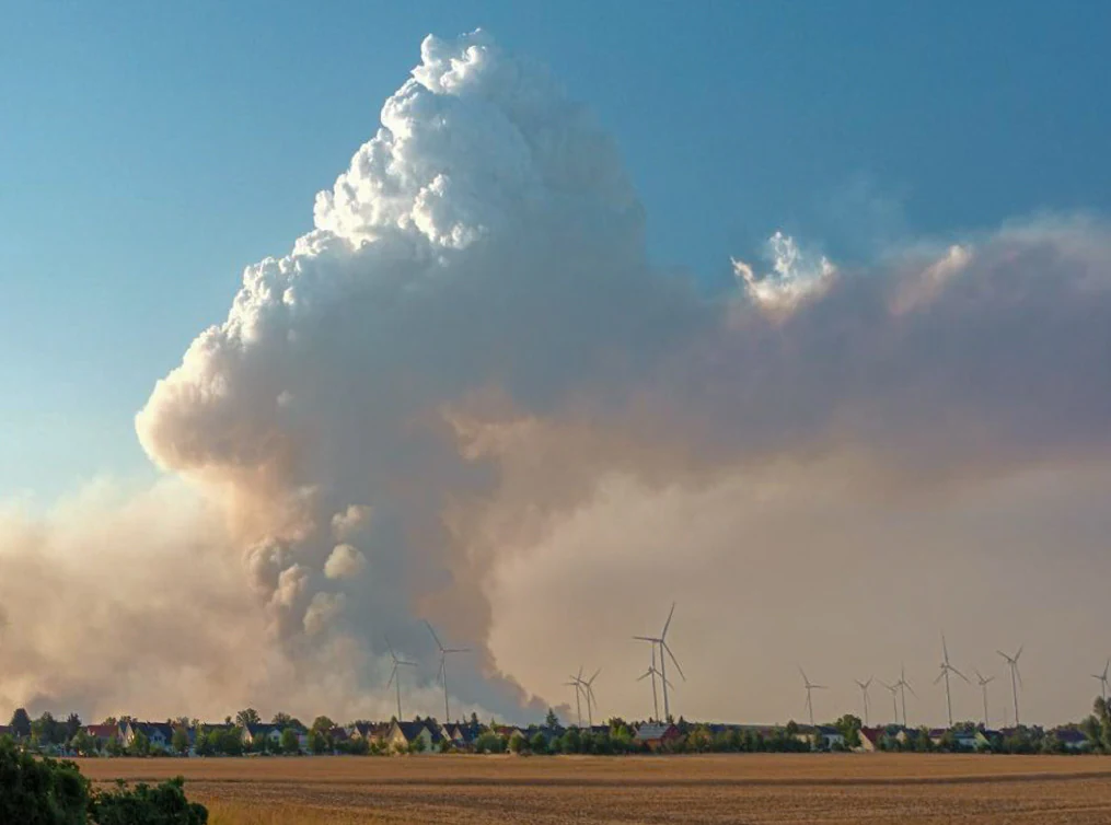
A massive plume of white and gray smoke rises into a clear blue sky above a flat horizon with wind turbines and a small residential settlement in the distance.
A large smoke plume from a forest fire in the Gohrischheide, visible from the distance near Zeithain.

Gohrischheide und Elbniederterrasse Zeithain history and protected-area timeline

The place name Gohrischheide preserves older landscape history that predates the reserve itself. The heath is named after the lost settlement of Gohrisch, a Vorwerk first mentioned in 1474 as "Gorisch." In 1895, the village was abandoned when the area was incorporated into the Truppenübungsplatz Zeithain, a large military training ground, and the surrounding heath became decades of restricted, almost inaccessible landscape. The name itself is thought to derive from an Old Sorbian root "*goriti," meaning "to burn," which is an early linguistic echo of the fire ecology that still defines the site today.

Modern protection is more recent. The Gohrischheide und Elbniederterrasse Zeithain was formally designated as a Naturschutzgebiet on 11 January 2011 through an ordinance issued by the Landratsamt Meißen (SächsGVBl. p. 45). At the same time, the area was incorporated into the EU Natura 2000 system as FFH-Gebiet Nr. 4545-304 and as the European Bird Protection Area Nr. 4545-451 "Gohrischheide." Today the forest administration of the area belongs to Staatsbetrieb Sachsenforst, with nature reserve administration tied to the Königsbrücker Heide / Gohrischheide unit.

A second, more turbulent chapter of the reserve's history has been written by fire. In late June 2022, a suspected arson-triggered ground fire burned at least 900 hectares of heath, forest, and farmland, including about 350 hectares on the Brandenburg side, and was described as the worst wildfire in Saxony in roughly thirty years. A smaller fire followed in 2023 in the southeastern part of the Gohrischheide.

The most dramatic fire came in July 2025, during the wider European drought and heat wave of that year. On 1 July 2025, fire broke out again in the munitions-contaminated zone; by 14 July, roughly 2,400 hectares, more than three quarters of the Gohrischheide, had burned. According to the forest service, recovery to the original ecological state is expected to take thirty to thirty-five years, until roughly 2055 to 2060, and the future ecosystem will not be identical to the pre-fire forest. Yet another fire in 2026, during the June 2026 European heat wave, burned around 16 hectares across multiple ignition points, underscoring that fire has become a recurring, defining force in the reserve's recent history.

Gohrischheide und Elbniederterrasse Zeithain landscape and geographic character

The landscape of Gohrischheide und Elbniederterrasse Zeithain is shaped by the Elbe's lower terrace, a flat to gently undulating plain of Pleistocene and post-glacial sands. Pale sandy soils dominate, and in many places they form inland dunes, low ridges, and open sandy flats. These are the substrate for the reserve's most distinctive combination of habitats: inland dunes with open grasslands, dry heaths, and patches of dry-warm semi-open land. Pine forest, shaped by past land use and the long closure of the former weapons range, surrounds and interleaves with these open areas.

The terrain is broadly open and dry, with horizons that stretch far in clear weather and a steppe-like, almost eastern European feel. Because much of the area remained inaccessible for over a century, the dune and heath features have been able to persist on a scale rarely seen elsewhere in Saxony. The openness also makes the area spectacular for fires: large flames can travel quickly over open sand and dry heath when weather conditions turn hot and windy.

Human infrastructure is intentionally minimal. The most visible built feature for visitors is a six-meter wooden observation tower erected in 2014 along the periphery, designed to give an overview of the surrounding heath without entering the most sensitive core. Beyond that, there are marked trails along selected edges of the reserve. The flatness, openness, and interrupted mosaic of forest and open sand give the protected area a distinctly different visual character from the more hilly landscapes usually associated with Saxony.

Gohrischheide und Elbniederterrasse Zeithain ecosystems, habitats, and plant life

Ecologically, the reserve is a textbook example of a dry, sandy inland ecosystem in central Europe. Its most valuable features are habitats of community importance under the EU Habitats Directive, specifically inland dunes with open grasslands and dry heaths. These habitats interlock with dry-warm semi-open land, whose plant communities include relict populations of purple mullein, Verbascum phoeniceum, a species the conservation plan explicitly aims to safeguard. The broader vegetation pattern is one of scattered open dunes and heaths embedded within pine-dominated forest on the Elbe lowland terrace.

Management of the area recognizes that some of the most valuable elements of the landscape only persist if natural processes are allowed to run their course. A 454-hectare special protection zone inside the reserve is therefore explicitly set aside for ecological succession and habitat development, rather than for direct human management. This approach is meant to maintain the open, dry character of the dunes and heaths even as the surrounding forest matures.

Fire is increasingly part of the ecological story. Major wildfires in 2022 and especially July 2025 burned through much of the heath and forest, creating large areas of post-fire early-succession habitat. Forest officials have noted that the post-fire ecosystem will not be fully identical to the original one, but will instead develop into a different, dynamic mosaic of open ground, regenerating heath, and young forest. In ecological terms, the reserve is therefore not a static conserved landscape but a changing one, shaped by sand, sunlight, dryness, and recurring fire.

Gohrischheide und Elbniederterrasse Zeithain wildlife and species highlights

The reserve's wildlife profile is closely tied to its open, dry habitats and its large size. The European Bird Protection Area designation (Nr. 4545-451 "Gohrischheide") reflects the importance of the heath and dune complex for bird species that depend on open dry land, low vegetation, and forest edge structure. The combination of inland dunes, dry heaths, scattered pine, and post-fire regeneration creates a varied mosaic of nesting and foraging conditions across a relatively continuous area, which is unusually rare in Saxony.

Among the most notable botanical-faunal signals is the dry-warm semi-open habitat, which supports sensitive plant communities including Verbascum phoeniceum. The invertebrate fauna associated with such open sandy habitats, including species specialized in warm, bare ground, is part of why the EU has designated the Habitats Directive habitat types as a community-wide priority. The size and openness of the area, along with limited public access, also means that wildlife in the deeper interior is largely undisturbed by recreation.

The reserve's populations exist in a fire-shaped landscape. Recurring large-scale wildfires in 2022 and 2025 reset ecological conditions over thousands of hectares, which in turn affects how wildlife uses the area in the years following each fire. Species that thrive in early post-fire successional habitat benefit from such openings, while species dependent on older pine forest or stable heath face shifts in habitat availability. This dynamic is now an integral part of the reserve's wildlife story, rather than an exceptional disruption of it.

Gohrischheide und Elbniederterrasse Zeithain conservation status and protection priorities

Gohrischheide und Elbniederterrasse Zeithain is a multi-layered conservation site, protected simultaneously under state, federal-European, and international frameworks. At the regional level it is a Naturschutzgebiet under Saxony's protected-area law, legally established in 2011. At the European level it is part of the Natura 2000 network as an FFH-Gebiet (Nr. 4545-304) and as a European Bird Protection Area (Nr. 4545-451), placing its most important habitats and bird populations under EU-level protection. Internationally, the World Database on Protected Areas lists the site under WDPA entry 318447, and IUCN manages it as a Category IV area, defined as a Habitat/Species Management Area.

The conservation value of the reserve lies in the persistence of inland dunes with open grasslands and dry heaths on the Elbe lowland terrace, habitat types that are scarce across central Europe. A roughly 454-hectare core zone is deliberately set aside for ecological succession and development, reflecting a management philosophy that aims to let natural dry-habitat dynamics continue rather than to actively cultivate them. Relict plant populations, including Verbascum phoeniceum, are specifically targeted for long-term safeguarding within this framework.

A defining conservation challenge is the intersection of high habitat value with high fire risk. The site has experienced repeated large-scale wildfires in 2022, 2023, 2025, and 2026, with the July 2025 event burning more than 2,400 hectares, more than three quarters of the Gohrischheide itself. Fire management here is complicated by widespread munitions contamination from the former military training ground, which limits access and complicates suppression. From a conservation perspective, fire is both a threat, because recovery to the original state will take decades, and a long-term ecological driver that reshapes the open, dry mosaic the reserve was created to protect.

Gohrischheide und Elbniederterrasse Zeithain cultural meaning and human context

Culturally, the reserve carries the memory of a landscape that was long closed to civilian life. The expansive heath takes its name from the lost settlement of Gohrisch, itself first mentioned in 1474 as "Gorisch," which was abandoned in 1895 to make room for the Truppenübungsplatz Zeithain military training ground. For roughly the next century, what is now a public nature reserve was effectively a weapons range, and only since 2011 has it been managed primarily as a conservation site.

Several place-name and regional identity threads run through the cultural context. The name Gohrischheide is believed to derive from an Old Sorbian root "*goriti," meaning "to burn," a striking local linguistic echo of the very fire dynamics that have shaped the area in modern times. Linguistically and culturally, the reserve sits in the broader Sorbian-German contact zone of eastern Saxony. Administratively it lies in Landkreis Meißen, between the peripheral communities of Zeithain, Wülknitz, and Gröditz/Nauwalde.

Human interaction with the landscape today is intentionally limited and carefully framed. Marked visitor trails and a wooden observation tower were added in selected peripheral areas in 2014, providing the public with some access while keeping the core, munitions-affected landscape undisturbed. The recent major wildfires have also become part of the cultural memory of the region, especially the July 2025 event, which reshaped the reserve at landscape-scale and prompted wider debate about climate adaptation and emergency funding in Saxony.

Top sights and standout views in Gohrischheide und Elbniederterrasse Zeithain

Gohrischheide und Elbniederterrasse Zeithain stands out as one of the largest lowland heath and inland dune complexes in Saxony, set on the Elbe's lower river terrace. Its protection spans multiple layers, from Saxon NSG status to EU Habitats Directive and Birds Directive sites, centered on the habitats of inland dunes with open grasslands, dry heaths, and dry-warm semi-open land. A 454-hectare core zone is dedicated to ecological succession and development.

The reserve is also defined by its recent fire history. Repeated large-scale wildfires in 2022, 2023, 2025, and 2026, including the July 2025 fire that burned more than 2,400 hectares, have made it a regional focal point for climate-related fire management. Combined with continuing munitions contamination from its former military use, this gives the site a distinctive character as both a high-value conservation landscape and a working example of how fire, ecology, and human history intersect in Saxony today.

Best time to visit Gohrischheide und Elbniederterrasse Zeithain

Late spring and early summer typically offer the most favorable conditions for experiencing the Heath character of the reserve, when flowering plants of the dry-warm semi-open land, including Verbascum phoeniceum, are visible and the open dune landscape contrasts strongly with the surrounding pine forest. Early morning and late afternoon light tends to bring out the pale sandy tones of the inland dunes, while cooler, calmer days are generally better for walking the marked peripheral trails and using the observation tower.

Hot, dry summer days highlight the other defining character of the area: fire risk. In recent years, major wildfires have occurred precisely during such heat and drought periods, including late June 2022 and early July 2025. Visitors should be aware that access may be restricted during active fire events or high fire-warning periods, and that large interior areas remain off-limits at all times because of munitions contamination. Spring and autumn are generally the most comfortable and safest windows for visiting the accessible edges of the reserve.

Monthly climate preview

Long-term temperature ranges and monthly precipitation patterns across representative terrain

Gohrischheide und Elbniederterrasse Zeithain Climate Normals and Weather by Month

Historical climate data for Gohrischheide und Elbniederterrasse Zeithain reveals measured annual temperature variations and monthly precipitation averages from representative coordinates. Comprehensive twelve-month climate profiles provide deeper analytical depth for regional temperature ranges and precipitation trends.
Annual mean9 °C
-1 °C20 °C
Jan-1°
Feb
Mar
Apr
May14°
Jun18°
Jul20°
Aug20°
Sep15°
Oct
Nov
Dec
Warmest month
July

20 °C

Coolest month
January

-0.7 °C

Wettest month
July

2.6 mm/day

Driest month
April

1.1 mm/day

Park location guide

Geography guide, regional context, and park location map for Gohrischheide und Elbniederterrasse Zeithain

Gohrischheide und Elbniederterrasse Zeithain park geography, regions, and map view in Germany

Understand where Gohrischheide und Elbniederterrasse Zeithain sits in Germany through a broader geographic reading of the surrounding landscape, nearby location context, and its mapped position within the national park landscape.

How Gohrischheide und Elbniederterrasse Zeithain fits into Germany

Germany is a federal republic in Western and Central Europe with a population of over 83 million across sixteen constituent states. It is Europe's largest economy by nominal GDP and a major global exporter and importer. The capital is Berlin, and the country borders Denmark, Poland, Czech Republic, Austria, Switzerland, France, Luxembourg, Belgium, and the Netherlands.

Wider geography shaping Gohrischheide und Elbniederterrasse Zeithain in Germany

Germany is located in Western and Central Europe, spanning 357,022 km². It borders Denmark to the north, Poland and the Czech Republic to the east, Austria and Switzerland to the south, and France, Luxembourg, Belgium, and the Netherlands to the west. The country has coastlines on the Baltic Sea and North Sea to the north, with the Alps located in the southern region.

Map view of Gohrischheide und Elbniederterrasse Zeithain

Use this park location map to pinpoint Gohrischheide und Elbniederterrasse Zeithain in Germany, understand its exact geographic position, and read its mapped placement within the surrounding landscape more clearly.

Pigeon | © OpenStreetMap contributors

Location context for Gohrischheide und Elbniederterrasse Zeithain

Saxony

Visualizing the inland dunes, dry heaths, and protected lowland terrain

Gohrischheide und Elbniederterrasse Zeithain Landscape Photos and Scenery

Visual records capture the expansive open sand landscapes, pine forests, and dry heath habitats that define the reserve. Examining these protected area views reveals the flat river terrace terrain and distinct ecological character shaped by natural succession and fire history.

A massive plume of white and gray smoke rises into a clear blue sky above a flat horizon with wind turbines and a small residential settlement in the distance.

A wide, flat landscape view of an open heath covered in low grasses and shrubs, with a line of trees on the horizon under a cloudy sky.

Park atlas

Compare surrounding regional geography, lowland river terraces, and neighboring nature reserves

Parks Near Gohrischheide und Elbniederterrasse Zeithain and Related Protected Areas

Browsing neighboring protected areas and regional reserves provides deeper geographic context for the unique inland dune and dry heath habitats found around Gohrischheide und Elbniederterrasse Zeithain. Expanding the conservation view across surrounding Saxon lowland landscapes helps visitors trace connected ecosystems, regional terrain patterns, and broader natural reserves.
A horizontal watercolor painting showing a soft, atmospheric wetland scene with green meadows, tall grasses, distant tree lines, and a pale pink and yellow sky.
Nature reserveBrandenburg
1.4 km away#1 closest

North

Kleine Röder Nature Reserve: Mapped Wetland Geography and Protected Landscape in Brandenburg

A vital Elbe-Mulde lowland corridor near Bad Liebenwerda

The Kleine Röder Nature Reserve functions as a major ecological link in northeastern Germany, protecting a 385 hectare mosaic of fens, wet meadows, and alluvial forests. This site is defined by its water-dominated terrain and its role as a habitat corridor in the Elbe-Mulde lowland, encompassing both rare wetland flora and the historic Kosilenzien Slavic ringwall within its official boundaries.

Area
3.65 km²
Established
2011
IUCN
IV
A soft, light-toned watercolor painting of a low, rolling landscape with green hills, sparse vegetation, and a suggestion of wetland or pond in the foreground.
Nature reserveSachsen
About 15 km away#2 closest

South

Seußlitzer und Gauernitzer Gründe: Protected Nature Reserve Map and Landscape Overview

Regional geography and habitat boundaries in the Sachsen Elbe valley.

Spanning steep slopes and narrow brook valleys on both sides of the Elbe, Seußlitzer und Gauernitzer Gründe is a defining nature reserve in Sachsen. This protected area supports a diverse mix of dry herbaceous vegetation and mature deciduous forest, serving as a critical component of the local ecological network within the broader Upper Elbe landscape.

Area
3.57 km²
Established
2013
IUCN
IV
Relief
Upland
Nature reserveSaxony
About 19 km away#3 closest

South

Trockenhänge südöstlich Lommatzsch: A Protected Dry-Slope Landscape in Saxony, Germany

Mapping rare grasslands and oak woodland habitats

Trockenhänge südöstlich Lommatzsch encompasses a unique network of non-contiguous parcels across the Ketzerbach valley. Formed on resilient Meißner monzonite bedrock, these sheltered slopes support threatened plant communities and high-value invertebrate habitats, standing as a critical protected fragment amidst the surrounding intensive agricultural landscape of Saxony.

A minimalist watercolor painting showing a horizontal landscape with patches of green forest and hints of marshy or open terrain against a white background.
Protected landscapeBrandenburg
About 19 km away#4 closest

Northeast

Naturpark Niederlausitzer Heidelandschaft: A Protected Landscape in Brandenburg

Mapping the glacial remnants and industrial heritage of a German lowland nature park

Naturpark Niederlausitzer Heidelandschaft offers an insightful look into the transformation of Brandenburg lowlands, where sessile oak forests, wet meadows, and post mining residual waters create a singular ecological mosaic. This destination captures the contrast between remnants of the last ice age and the deliberate rewilding of former opencast pits, providing a deep view into regional landscape evolution.

Area
484.3 km²
Established
1996
Relief
Lowland
Climate
Temperate
Nature reserveSachsen
About 19 km away#5 closest

Southeast

Winzerwiese und Gosebruch: Protected Nature Reserve and Valley Geography in Sachsen

Mapping protected wet meadows and floodplain woodlands

Winzerwiese und Gosebruch is a distinctive nature reserve in Sachsen, Germany, centered on a small valley along the Gosebach stream. This protected area creates a dense mosaic of wet meadow, marshy woodland, and dry deciduous forest, offering a significant look at the region's diverse botanical landscape and river-valley geography.

Area
0.116 km²
Established
1967
IUCN
IV
Nature reserveBrandenburg
About 25 km away#6 closest

North

Alte Elster und Rieke: Protected Floodplain and River Geography in Brandenburg

Nature reserve featuring old river arms and wetland mosaics.

The Alte Elster und Rieke nature reserve represents one of the few surviving near-natural floodplain remnants along the Schwarze Elster river. This area supports a rich network of ponds, reed beds, and wet meadows that serve as a crucial refuge for wetland plants and wildlife within the otherwise heavily regulated Elbe-Elster lowland landscape.

Area
1.756 km²
Established
1981
IUCN
IV
Relief
Lowland
Nature reserveBrandenburg
26 km away#7 closest

Northeast

Welkteich Nature Reserve: Brandenburg Industrial Legacy and Protected Habitat Mapping

Mapping a unique mosaic of post-mining terrain and historic pond systems

Located in the district of Oberspreewald-Lausitz, Welkteich represents a distinct example of how industrial-era mining scars and artificial ridges can evolve into protected nature reserves. The site serves as a vital ecological corridor, featuring a dense interspersion of aquatic basins, forest patches, and dry ground that provides a sanctuary for diverse species within the broader Brandenburg landscape.

Area
1.13 km²
Established
1981
IUCN
IV
Relief
Lowland
A soft watercolor painting of a green, marshy landscape with a winding waterway and rolling hills in the background.
Nature reserveSaxony
About 26 km away#8 closest

Northwest

Großer Teich Torgau: A Protected Saxon Reservoir and Historic Wetland Map

Exploring the medieval pond culture and nature reserve boundaries in Saxony

Located in northern Saxony, Großer Teich Torgau is a rare surviving medieval fish pond that functions as a nature reserve and flood management reservoir. This protected landscape contains shallow water zones, historic earthen dam structures, and surrounding marshlands that illustrate centuries of continuous human and natural interaction within the regional geography.

Area
1.75 km²
Established
1484
Relief
Lowland
Scope
Terrestrial

Common questions about visiting, size, designation, and location context for Gohrischheide und Elbniederterrasse Zeithain

Gohrischheide und Elbniederterrasse Zeithain FAQs for park facts, access, geography, and protected area context

Find quick answers about Gohrischheide und Elbniederterrasse Zeithain, including protected-area facts, park geography, trail and visitor context, and how the park fits into its surrounding country and regional landscape.
MoriAtlas Explorer

Continue Your Protected Areas Search Across the Global Atlas

Deepen your exploration by continuing the structured search for national parks and protected areas worldwide. Utilize the comprehensive filtering capabilities to compare different conservation landscapes and refine your understanding of global park geography. Discover more about the distribution and characteristics of protected natural areas.

Global natural geography