
Mountain saddles
Park geography
Examine the recorded land area, mountain elevation metrics, and diverse watershed features.
Structured Geographic and Terrain Profile of Shasta–Trinity National Forest in California
This geographic profile details the physical characteristics of Shasta–Trinity National Forest in California. Access data on its total land area of 8942 square kilometers, high-altitude mountain terrain reaching 4322 meters, and extensive network of interior streams including the South Fork Trinity River.
Northern California's largest national forest, encompassing Mount Shasta, Shasta Lake, and the Trinity Alps.
Shasta, Trinity National Forest
Shasta–Trinity National Forest is a federally protected forest in northern California and the largest national forest in the state. It spans parts of six counties and covers roughly 2.2 million acres, an area large enough to contain entire mountain ranges, dozens of lakes, and thousands of miles of streams. The forest is defined by two iconic geographic anchors: Mount Shasta, a 14,179-foot stratovolcano dominating the east side of the forest, and Shasta Lake, California's largest reservoir, fringed by nearly 370 miles of shoreline. The forest lies at the meeting point of the Klamath Mountains and the southern Cascade Range, producing a remarkable gradient of vegetation that runs from oak and chaparral foothills all the way up to subalpine rock and alpine meadows. Five congressionally designated wilderness areas fall within its boundaries, including the Trinity Alps and Mount Shasta wildernesses, preserving corridors of relatively untouched mountain territory in an otherwise heavily modified region of California. Managed by the U.S. Forest Service, Shasta–Trinity is a working landscape that combines timber production, watershed protection, recreation, and conservation. It serves as a year-round outdoor destination, supporting everything from lake-based recreation at Shasta Lake to backcountry trips along more than 460 miles of trails, including a long stretch of the Pacific Crest Trail.
- Location
- United States of America
- Park type
- Protected landscape
- Established
- 1954
- Area
- 8,942.9 km²
- Highest point
- 4,322 m
Location overview
National Protected Area Records for California and the United States
Geographic Overview and Regional Location of Shasta–Trinity National Forest
Shasta–Trinity National Forest is located within the United States of America and the state of California. Official administrative records outline its recorded regional memberships and high-level geographic status.
- Countries
- United States of America
- Regions
- California
- Primary location
- California
- Geographic setting
- Inland
Boundary and coordinates
Interactive boundary geometry and recorded area measurements
Shasta–Trinity National Forest Boundary Map and Spatial Extent
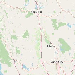
Mapped geographic outlines provide spatial context for the protected area. Structured boundary facts detail total land area spans and coordinate limits without surveying precision.
- Boundary area
- 10,963.1 km²
- Boundary perimeter
- 2,150.9 km
- Northernmost point
- 41.5832° N
- Southernmost point
- 40.0753° N
- Easternmost point
- 121.5238° W
- Westernmost point
- 123.5863° W
- Geographic centre
- 40.9203° N, 122.6497° W
- North–south span
- 167.4 km
- East–west span
- 174 km
Elevation and terrain
Track peak altitude metrics and documented internal stream networks.
Shasta–Trinity National Forest Elevation Profile and Mountain Terrain Mapping
Recorded elevation records place the highest point at 4322 meters across this mountain park terrain. Associated feature cards detail individual streams located within the protected boundary.
- Highest point
- 4,322 m
Selected named natural features
Viewpoints
Overlook
Mountain saddles
Whalan Summit
Mountain saddles
Damnation Pass
1,304 m
Mountain saddles
Ramshorn Summit
1,553.9 m
Mountain saddles
Sanford Pass
1,348 m
Environmental setting
Temperate mountain relief and major water features across diverse protected terrain
Shasta–Trinity National Forest Environmental Setting and Landscape Classifications
Recorded landscape features and temperate climate zones frame the physical setting across mountain relief and major water networks. Linked categories connect stored environmental classifications to related protected-area destinations.
- Relief
- Mountain
- Climate
- Temperate
- Water
- Major water bodies
Landscape features
Mountains · Valleys · Forest · Woodland · Grassland · Wetland · Lakes · Rivers · Volcano
Park atlas
Compare regional mountain ranges, volcanic highlands, and connected forest reserves
Parks Near Shasta–Trinity National Forest and Surrounding Protected Landscapes
Browsing other protected areas near Shasta–Trinity National Forest reveals broader regional connectivity across northern California mountain terrain. Comparing adjacent wilderness zones and volcanic reserves provides deeper geographic context for the surrounding Klamath and Cascade ecosystems.

Protected landscapeCalifornia
Park boundaries overlap#1 closest
East

Lassen National Forest: Mapped Geography and Protected Landscapes of Northern California
Volcanic terrain and expansive old growth ecosystems
Lassen National Forest represents a vast protected landscape in Northern California, defined by its severe volcanic geology and resilient conifer forests. This atlas entry provides essential geographic context regarding the forest boundaries, the volcanic rim of Mount Tehama, and the intricate river systems shaping the region. Explore the terrain, from accessible lava tubes to the wilderness areas preserved within this significant mountain corridor.
- Area
- 4,331.53 km²
- Established
- 1905
- Relief
- Mountain
- Climate
- Temperate
Protected landscapeCalifornia
Park boundaries overlap#2 closest
South
Mendocino National Forest: Mapping California's Remote Protected Mountain Landscape
Examining wilderness boundaries and rugged coastal terrain
Mendocino National Forest serves as a significant protected area in California, known for being the only national forest in the state without major paved access. Its terrain spans 913,000 acres of mountain peaks, deep river canyons, and old-growth conifer forests. Home to the unique tule elk population at Lake Pillsbury, this landscape provides a rare example of wilderness isolation, complex geothermal features, and rugged, largely untouched northern coastal topography.
- Area
- 3,696.02 km²
- Established
- 1907
- Relief
- Mountain
- Climate
- Mediterranean
Protected landscapeCalifornia
Park boundaries overlap#3 closest
Northeast
Modoc National Forest: Protected Landscape and Warner Mountains Geography
High desert volcanic terrain in northeastern California
Modoc National Forest encompasses a massive expanse of volcanic plateaus and rugged mountain ridges in the northeastern corner of California. This protected area offers significant geographic variety, transitioning from arid sagebrush basins to lush, high-elevation conifer forests. It serves as a vital natural landscape, home to the South Warner Wilderness and large stands of old-growth timber, reflecting the unique geologic history of the regional lava flows.
- Area
- 6,695.09 km²
- Established
- 1904
- Relief
- Mountain
- Access
- Moderate access
Wildlife reserveCalifornia
Park boundaries overlap#4 closest
Northeast
Mount Shasta Wilderness: A Geographic Profile of California Volcanic and Alpine Landscapes
Mapping protected volcanic peaks and glacial ecosystems
Deeply explore the protected geography of Mount Shasta Wilderness, a 38,200-acre reserve in Northern California. This record details the park's stratovolcano foundations, glacial terrain, and forested corridors, offering a clear view of the complex landforms and boundary systems that define this significant high-elevation protected area.
- Area
- 155 km²
- Established
- 1984
- IUCN
- Ib
- Relief
- Mountain
Protected areaCalifornia
Park boundaries overlap#5 closest
Northwest
Six Rivers National Forest: Exploring Protected River Valleys and Mountain Terrain in California
A regional protected area spanning California river systems
Six Rivers National Forest defines much of the rugged landscape in northwestern California. Named for the six major river drainages within its borders, the area features a unique combination of coastal forests, deep river canyons, and high-country ridges that offer significant insight into the region's broader geographic and ecological character.
- Area
- 3,875.2 km²
- Established
- 1947
- Relief
- Mountain
- Climate
- Mediterranean
Protected landscapeCalifornia
5.1 km away#6 closest
East
Whiskeytown, Shasta, Trinity National Recreation Area: Geographic and Protected Landscape Overview
Mapped terrain across northern California reservoir units
Investigate the environmental character of Whiskeytown, Shasta, Trinity National Recreation Area, spanning from the expansive waters of Shasta Lake to the forested ridges of the Whiskeytown unit. This atlas entry details the interplay between large-scale reservoir management, riparian habitats, and the transition from Mediterranean chaparral to high-elevation conifer forests in California.
- Area
- 99,588 km²
- Established
- 1965
- IUCN
- V
- Visitors
- 1.5M annual
Protected landscapeCalifornia
19 km away#7 closest
North
Marble Mountain Wilderness: Exploring Protected Mountain Landscapes in Northern California
Klamath Mountains Wilderness and Alpine Geography
Spanning hundreds of thousands of acres, Marble Mountain Wilderness offers a dense concentration of subalpine fir, deep glacial lakes, and steep drainage basins. This northern California protected landscape provides an atlas of rugged ridges and marble-toned peaks that represent one of the most ecologically diverse backcountry areas in the region.
- Area
- 978.3 km²
- Established
- 1964
- IUCN
- Ib
- Relief
- Mountain
National parkCalifornia
32 km away#8 closest
Northwest
Redwood National and State Parks: Protected Landscape Geography and Mapped Boundaries
Explore California's protected area atlas.
Gain a structured understanding of Redwood National and State Parks as a protected national park within the geographic context of California. This dedicated page focuses on its mapped boundaries and protected landscape identity, offering critical atlas-level insights for regional geography exploration and conservation land context. Discover how this protected area fits into the larger mapped terrain.
- Area
- 562.88 km²
- Established
- 1968
- IUCN
- V
- Visitors
- 458.4K annual
MoriAtlas Explorer
Explore the Mapped Geography and Protected Landscapes of Shasta–Trinity National Forest
Continue your geographic exploration into the complex terrain of Shasta–Trinity National Forest. MoriAtlas provides a clear view of the mountain ranges, reservoir systems, and vast wilderness boundaries that define this essential Northern California protected landscape.
Browse next
Global natural geography
Explore related park routes
Explore MoriAtlas Global ParksBrowse All MoriAtlas ParksGlobal Park Map DiscoveryMoriAtlas: Browse All CountriesBrowse All MoriAtlas ContinentsNational Park Environment AtlasGrand Canyon National Park AtlasYellowstone National Park AtlasYosemite National Park Atlas and GeographySerengeti National Park AtlasGalápagos National Park Protected LandscapeBanff National Park Geography and AtlasKruger National Park Atlas EntryUluṟu-Kata Tjuṯa National Park AtlasExplore Uluru-Kata Tjuta National Park GeographyPlitvice Lakes National Park AtlasFiordland National Park Protected LandscapeGreat Smoky Mountains National Park AtlasAfghanistan National Parks and Protected AreasAlbania National Parks and Protected AreasAlgeria National Parks and Protected AreasAmerican Samoa National Parks and Protected AreasAndorra National Parks and Protected AreasAngola National Parks and Protected AreasAntarctica National Parks and Protected AreasAntigua and Barbuda Park List