Mori Atlas logo
Nature reserveSinngrund

A detailed geographic atlas of wet meadows, near-natural river corridors, and floodplain ecosystems.

Sinngrund Nature Reserve: Mapping the Protected River Valley Landscapes of Landkreis Main-Spessart

Sinngrund represents a protected corridor along the lower Sinn river valley, defined by its extensive wet meadows, relict oxbow waters, and fragmented floodplain forests. The landscape serves as a critical habitat for specialized botanical populations and local beaver colonies within the Naturpark Spessart. This atlas entry provides a comprehensive geographic perspective on the reserve boundaries and its ecological role within the wider Main-Spessart district.

wet meadowriver valleyfloodplainsnake's head fritillarybeaver habitatNaturpark Spessart

Sinngrund

Nature reserve

Park overview

Structured park overview, official facts, and landscape profile for Sinngrund Nature Reserve

Sinngrund Nature Reserve park facts, protected area profile, and essential visitor context

Review the core facts for Sinngrund Nature Reserve, including designation, size, terrain, visitor scale, habitats, and operating context in one park-focused overview.

About Sinngrund Nature Reserve

Sinngrund is a nature reserve in the Landkreis Main-Spessart in Lower Franconia, Bavaria, and represents one of the most meadow-rich conservation areas along the Sinn river. The reserve runs through the lower portion of the Sinn valley, the same name being shared by the river and the valley, and sits within the larger Naturpark Spessart, a long-established mixed forest and cultural landscape of central Germany.

The protected site covers about 379 hectares, organized into eight geographically distinct subsections that are separated by roads, settlements such as Obersinn, Mittelsinn, Burgsinn, Rieneck, and Schaippach, and by the Hanover-Würzburg high-speed railway line. To the north, the Bavarian reserve transitions into the Hessian Sinnwiesen von Altengronau, extending the ecological corridor across state borders.

Ecologically, Sinngrund is shaped by the near-natural Sinn river, which meanders through a wide meadow valley and has left behind oxbow waters and fragments of alluvial forest along the valley floor. These wetland features create the conditions for some of Germany's most important lowland meadow habitats and serve as the foundation for the reserve's conservation priorities in flora and fauna.

The reserve is administered by the Bayerisches Landesamt für Umwelt and is registered in international databases as both a protected area and a Natura 2000 site, with overlapping designation as an FFH (Flora-Fauna-Habitat) area of about 409 hectares. This layered protection reflects both the botanical rarity and the broader habitat value of the Sinn valley system.

Quick facts and research context for Sinngrund Nature Reserve

Sinngrund is a nature reserve (Naturschutzgebiet) in Bavaria, Germany, established in April 1999 under the protection designation NSG-00559.01. The reserve occupies roughly 379 hectares within the Naturpark Spessart and overlaps with the larger FFH (Habitats Directive) site of about 409 hectares.

The protected landscape lies in the lower valley of the Sinn river, between Obersinn and Gemünden am Main, and is divided into eight sections. Its ecological significance is tied to wet meadows, floodplain forest remnants, and a near-natural river course that sustains specialized plant species and supports an important beaver population in the Spessart.

Protection and recognition

Documented terrestrial protection framework and Natura 2000 records for Sinngrund

Sinngrund Protection Status and International Recognition Data

Sinngrund maintains a documented terrestrial protection scope backed by official Natura 2000 recognition records. Structured administrative data outlines the conservation framework and designation history associated with this protected area.

International recognition

Protection details

Protection scope
Terrestrial
Transboundary protection
No
WDPA ID
319114
Park context

Deeper park guide and search-rich context for Sinngrund Nature Reserve

Sinngrund Nature Reserve history, landscape, wildlife, and travel context

Explore Sinngrund Nature Reserve through its history, landscape character, ecosystems, wildlife, conservation priorities, cultural context, and seasonal travel timing in a structured park guide built for atlas discovery and search intent.

Why Sinngrund Nature Reserve stands out

Sinngrund is best known for holding Germany's largest native population of the snake's head fritillary (Fritillaria meleagris), a spring-flowering bulb whose checkered purple flowers are an icon of traditional wet meadows. The same valley also supports the only known Bavarian occurrence of the hair-leaved water fennel (Oenanthe peucedanifolia), a rare wetland specialist. Beyond its botanical pedigree, the reserve is recognized as a focal area for the beaver population in the Spessart, reflecting the restoration value of its near-natural river, oxbow waters, and floodplain habitats. Together these qualities make Sinngrund a flagship site for conservation of lowland riverine meadow ecosystems in central Germany.
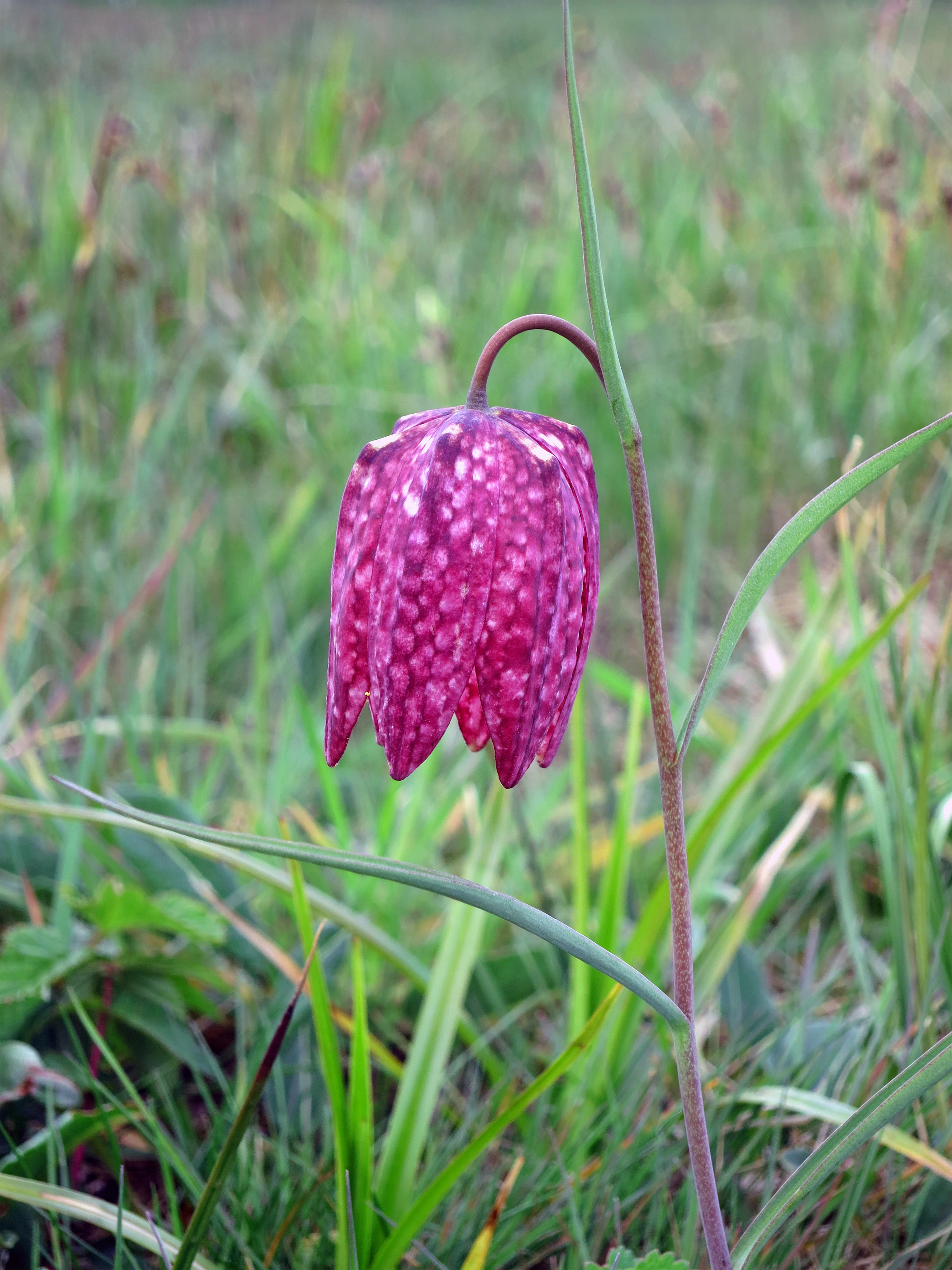
A close up of a single purple, checkered snake's head fritillary flower hanging from a slender green stem in a grassy meadow.
A snake's head fritillary blooming in the damp meadows of the Sinngrund nature reserve.

Sinngrund Nature Reserve history and protected-area timeline

Sinngrund was formally designated as a nature reserve in April 1999, marking the legal recognition of a long-standing ecological importance along the lower Sinn river. The designation established the eight-part protected area in the Landkreis Main-Spessart as an official NSG (Naturschutzgebiet) under Bavarian conservation law.

The reserve was structured to account for the practical fragmentation of the valley, where settlements, the state road Staatsstraße 2304, and the high-speed Hannover-Würzburg railway line divide the meadows into discrete sections. Conserving these sections as a single designated unit reflects an understanding of the valley as one ecological corridor rather than as isolated farmland patches.

Following designation, Sinngrund also became part of the Natura 2000 network as a Flora-Fauna-Habitat site, broadening its protection from a national nature reserve to a transnational habitat conservation framework. The overlap of designations underpins ongoing efforts to maintain the valley's wet meadows, oxbow waters, and floodplain forest remnants as a connected ecological system.

Sinngrund Nature Reserve landscape and geographic character

The landscape of Sinngrund is defined by the broad, gently sloping meadow valley of the Sinn river in the Naturpark Spessart. The river runs close to its natural condition here, cutting a wide alluvial corridor between forested uplands of the Spessart highlands and opening out toward the Main valley near Gemünden am Main.

The valley floor is dominated by open wet meadows and pastures, interrupted by shallow oxbow channels and backwaters left by the river's natural shifting. Scattered fragments of floodplain forest line these old channels, preserving patches of alder and other wetland trees that contrast with the surrounding grassland.

Surrounding the valley, the Spessart presents a wooded backdrop typical of central German low mountain country, with mixed forest along the slopes. The protected area is visually modest in scale but ecologically distinct, and the contrast between the wide, open, water-shaped valley floor and the darker, forested slopes is a defining element of the Sinngrund scenery.

Sinngrund Nature Reserve ecosystems, habitats, and plant life

Sinngrund protects one of Bavaria's most important lowland riverine meadow complexes. The core ecological character is built around near-natural river dynamics, resulting in a mosaic of wet meadows, oxbow waters, and remnant floodplain forest along the Sinn.

Seasonally flooded and permanently moist grasslands dominate the open valley floor, supporting a range of specialized meadow plants adapted to periodic inundation and nutrient-rich alluvial soils. These wet meadows are the foundation of Sinngrund's botanical importance and provide habitat continuity for moisture-dependent invertebrates and birds.

The floodplain woodland fragments contribute structural diversity, while the varied hydrology, with active channels, stagnant oxbows, and saturated soils, sustains a multi-layered habitat mosaic. This combination of grassland, water, and woodland makes the reserve a stronghold for wetland biodiversity within the otherwise forest-dominated Spessart region.

Sinngrund Nature Reserve wildlife and species highlights

Sinngrund is most notable as a focal area for the Eurasian beaver (Castor fiber) in the Spessart, benefiting from the near-natural river course, the network of oxbow waters, and the protective fringe of floodplain vegetation. The valley provides both foraging habitat and stable denning sites, supporting a regionally important beaver population.

The wet meadows, oxbow channels, and remaining floodplain forest also create habitat for a variety of wetland-associated fauna, including amphibians, dragonflies, and bird species tied to open water and marshy grassland. The continuity of these habitat types across the eight reserve sections, despite their fragmentation by roads and railway, helps maintain viable wildlife populations along the Sinn.

The reserve's botanical richness, anchored by the snake's head fritillary and the hair-leaved water fennel, also supports pollinator and invertebrate communities adapted to traditional, extensively managed meadows. Together these elements give Sinngrund a high ecological density disproportionate to its modest size.

Sinngrund Nature Reserve conservation status and protection priorities

Sinngrund carries substantial conservation value as one of Bavaria's most important sites for the protection of traditional wet meadow ecosystems. Its designation as a nature reserve in 1999 and its designation as an FFH (Flora-Fauna-Habitat) area reflect both national and European-level recognition of the valley's ecological significance.

The reserve protects Germany's largest autochthonous population of the snake's head fritillary (Fritillaria meleagris), a species strongly associated with undisturbed, traditionally managed wet meadows, as well as the only known Bavarian occurrence of the rare hair-leaved water fennel (Oenanthe peucedanifolia). These populations elevate Sinngrund from a local meadow protection site to a site of national botanical importance.

At the same time, the reserve secures a near-natural stretch of the Sinn river with associated oxbow systems and floodplain forest relics, providing refuge for beavers and other wetland-dependent species. The cross-border continuity with the Hessian Sinnwiesen von Altengronau further strengthens the conservation network along the river, helping maintain ecological processes across administrative boundaries.

Sinngrund Nature Reserve cultural meaning and human context

The Sinngrund lies along a traditional rural corridor in the Spessart region of Lower Franconia, where villages such as Obersinn, Mittelsinn, Burgsinn, and Rieneck have shaped the valley landscape for centuries. The meadows of the Sinn river are a product of long-standing agricultural use, with extensive hay production and grazing having created and maintained the very open habitats that the reserve now protects.

Small towns like Rieneck, dominated by its historic castle, and the surrounding villages give the valley a distinct local cultural identity rooted in the river, agricultural land use, and the forested Spessart uplands. The presence of state infrastructure, including the Hannover-Würzburg high-speed railway, also narrates the modern intersection of the valley's traditional landscape with contemporary transport corridors.

Today, Sinngrund reflects a regional model where the continuation of low-intensity, traditional meadow management supports both agricultural heritage and the conservation of rare meadow flora and fauna.

Top sights and standout views in Sinngrund Nature Reserve

The standout features of Sinngrund include Germany's largest native population of the snake's head fritillary, the only Bavarian occurrence of the hair-leaved water fennel, and a near-natural stretch of the Sinn river with oxbow waters, extensive wet meadows, and relict floodplain forest.

The reserve also functions as a key refuge for the Spessart beaver population and bridges into the Hessian Sinnwiesen von Altengronau to the north, creating a continuous protected corridor along the Sinn river valley in two German states.

Best time to visit Sinngrund Nature Reserve

Sinngrund is best appreciated in spring, when the snake's head fritillary blooms across the wet meadows around Obersinn and the broader valley, turning the grasslands into one of Germany's most distinctive displays of this rare species. Late spring and early summer also offer peak meadow vegetation and active wildlife along the river and its oxbows.

Summer brings lush green meadows and the full activity of wetland wildlife, including beaver presence along the Sinn river, while autumn highlights the changing character of the floodplain forest remnants and the broader Spessart backdrop. The valley is essentially a year-round destination for those interested in riverine meadow ecosystems, with each season offering a different facet of its flora, hydrology, and wildlife.

Monthly climate preview

Long-term monthly temperature and precipitation data for protected terrain in Landkreis Main-Spessart

Sinngrund Climate Normals and Measured Annual Temperature Rhythm

Representative coordinates record annual temperature extremes spanning sub-zero winter minimums and warm summer maximums alongside steady daily precipitation rates. Detailed weather by month breakdowns and complete climate records provide full analytical depth for the protected landscape.
Annual mean9 °C
-1 °C19 °C
Jan-1°
Feb
Mar
Apr
May13°
Jun17°
Jul19°
Aug19°
Sep14°
Oct
Nov
Dec
Warmest month
July

19.5 °C

Coolest month
January

-0.6 °C

Wettest month
July

2.4 mm/day

Driest month
April

1.5 mm/day

Park location guide

Geography guide, regional context, and park location map for Sinngrund Nature Reserve

Sinngrund Nature Reserve park geography, regions, and map view in Germany

Understand where Sinngrund Nature Reserve sits in Germany through a broader geographic reading of the surrounding landscape, nearby location context, and its mapped position within the national park landscape.

How Sinngrund Nature Reserve fits into Germany

Germany is a federal republic in Western and Central Europe with a population of over 83 million across sixteen constituent states. It is Europe's largest economy by nominal GDP and a major global exporter and importer. The capital is Berlin, and the country borders Denmark, Poland, Czech Republic, Austria, Switzerland, France, Luxembourg, Belgium, and the Netherlands.

Wider geography shaping Sinngrund Nature Reserve in Germany

Germany is located in Western and Central Europe, spanning 357,022 km². It borders Denmark to the north, Poland and the Czech Republic to the east, Austria and Switzerland to the south, and France, Luxembourg, Belgium, and the Netherlands to the west. The country has coastlines on the Baltic Sea and North Sea to the north, with the Alps located in the southern region.

Map view of Sinngrund Nature Reserve

Use this park location map to pinpoint Sinngrund Nature Reserve in Germany, understand its exact geographic position, and read its mapped placement within the surrounding landscape more clearly.

Pigeon | © OpenStreetMap contributors

Location context for Sinngrund Nature Reserve

BayernLandkreis Main-Spessart
Recorded earthquake history

Explore Recorded Earthquake History Near Sinngrund Nature Reserve

Review a detailed list of historically recorded seismic events identified within the vicinity of Sinngrund. Access event-specific data including magnitudes and epicentre locations through this curated collection on MoriAtlas, which provides a transparent overview of regional historical seismic activity.

Sinngrund Earthquake History

Catalogued events

7 events

Strongest magnitude

Magnitude 5.3

Most recent event

Jul 2, 2001

This history includes earthquakes recorded inside the park or within 50 km of its borders

Visual reference for the river valley, wet meadows, and floodplain habitats of Sinngrund

Sinngrund Landscape Photos and Protected Valley Scenery

Visual documentation captures the broad meadow valley, winding river corridors, and forested uplands that define the protected landscape of Sinngrund. Photographic records reveal the ecological character of oxbow waters and wetland habitats across the Spessart region.

A close up of a single purple, checkered snake's head fritillary flower hanging from a slender green stem in a grassy meadow.

Park atlas

Discover adjacent valley reserves and surrounding regional park geography

Explore Protected Areas and Parks Near Sinngrund

Compare Sinngrund with other protected river valleys and wetland reserves across the surrounding region. Broaden your geographic analysis by examining connected conservation landscapes and adjacent lowland habitats.
A soft, horizontal watercolor painting showing rolling green hills, distant mountain outlines, and clusters of evergreen trees against a pale sky.
Nature reserveHessen
12 km away#1 closest

Northwest

Bellinger Berg Nature Reserve: Geography and Protected Land Boundaries in Hessen

Muschelkalk limestone cone and dry grassland mosaic

Bellinger Berg serves as a critical example of protected limestone landforms in Hessen. The nature reserve encompasses a 345-meter conical hill where specialized calcareous grassland and scrubland thrive on thin, base-rich soils. By maintaining this habitat mosaic, the site provides a vital ecological bridge within the broader eastern Spessart region, preserving the site's distinct silhouette and historical landscape character.

Area
0.955 km²
Established
1985
IUCN
IV
Relief
Mountain
Nature reserveHessen
14 km away#2 closest

Northwest

Ohlsteinbruch bei Steinau an der Straße: Geographic Profile of the Hessen Nature Reserve

Mapped protected landscape featuring basalt outcrops and juniper heaths.

Ohlsteinbruch bei Steinau an der Straße provides a study in ecological resilience, showcasing how an abandoned basalt quarry has transformed into a high-diversity sanctuary for rare flora and invertebrates. The protected area features a unique mix of silicate rock communities, mat-grass swards, and dry meadows that reflect the complex geology of the Main-Kinzig district. This site serves as a vital Natura 2000 element, preserving essential habitats and cultural landscapes across its 25-hectare footprint.

Area
0.254 km²
Established
1984
IUCN
IV
Relief
Upland
A watercolor painting showing a soft, stylized landscape of rolling hills, grassy meadows, and patches of forest under a light sky.
Nature reserveBayern
About 27 km away#3 closest

South

Rohrberg Nature Reserve: Mapped Protected Oak Forest and Hochspessart Landscape in Bayern

Historic ancient oak woodland and rare habitat geography

Rohrberg Nature Reserve is an essential protected area in Bayern, distinguished by its ancient, open oak canopy and rich deadwood mosaic. This historic woodland landscape in the Hochspessart region offers a deep look into cultural forest management and the resulting specialized habitats for rare birds, beetles, and fungi within a singular protected environment.

Area
0.099 km²
Established
1928
Protected landscapeHesse
About 32 km away#4 closest

Northeast

Naturpark Hessische Rhön: Geographic Profile and Protected Landscape Mapping

Mapping the Rhön low mountains and upland ecosystems in Hesse

Naturpark Hessische Rhön encompasses approximately 720 square kilometers of varied terrain north and west of Fulda. The area features a distinct mosaic of forests, streams, and protected biotope complexes. This overview provides insight into the regional geography and the conservation structure defining this prominent upland protected landscape.

Area
720 km²
Established
1962
Relief
Upland
Scope
Terrestrial
A watercolor painting depicting a soft, stylized horizon of rolling, purple and pink hills behind a line of light green trees and meadow, against a white background.
Nature reserveHesse
About 32 km away#5 closest

Northeast

Rotes Moor Nature Reserve: Geography and Protected Bog Landscapes in the Rhön

Highland plateau ecosystems in Hesse, Germany

The Rotes Moor nature reserve is a centerpiece of the Rhön range, showcasing a complex highland bog that has undergone decades of systematic rewetting and ecological restoration. This protected landscape contains a rare mosaic of peat moss, floating mire surfaces, and birch woodlands, all framed by the dramatic volcanic basalt summits of the Hohe Rhön.

Area
3.147 km²
Established
1979
Relief
Highland
Climate
Alpine
Watercolor painting of a sweeping, green highland landscape with rolling hills in the background and a winding stream flowing through meadow and moorland.
Nature reserveThüringen
About 32 km away#6 closest

Northeast

Lange Rhön Nature Reserve: A Detailed Map and Geographic Overview of the Basalt Plateau

Highland meadow and bog landscape in Thüringen

Lange Rhön serves as the central basalt spine of the Rhön highlands, featuring a long, narrow plateau characterized by gentle slopes and wide-reaching views. This protected nature reserve encompasses significant raised bog systems and extensive grassland habitats, providing essential insights into the volcanic geology and upland biodiversity of the central German region.

Relief
Mountain
Climate
Temperate
Access
Moderate access
Scope
Terrestrial
Nature reserveLandkreis Fulda
About 33 km away#7 closest

Northeast

Kesselrain Nature Reserve: Protected Woodland Geography in the Rhön Region of Hesse

Mapping a historic nature reserve in Landkreis Fulda

Kesselrain represents a key conservation site within the Rhön mountains, offering a look at structurally complex forest habitats and north-facing slopes with alpine-influenced vegetation. Spanning over thirty hectares, this nature reserve in Landkreis Fulda serves as a prime example of protected woodland geography and diverse mountain terrain within the German state of Hesse.

Area
0.316 km²
Established
1940
Protected landscapeBaden-Württemberg
About 34 km away#8 closest

South

Wertheim Protected Landscape: Regional Geography and Sandstone Plateau Mapping

An enduring protected landscape within the Main-Tauber district of Baden-Württemberg.

Spanning 39 square kilometers across the towns of Wertheim, Freudenberg, and Külsheim, this protected area safeguards a classic Main-Franconian sandstone countryside. Its rolling plateau, shaped by red sandstone geology, integrates historic land use patterns with diverse woodland patches, meadows, and river valley streams to preserve a coherent regional landscape.

Area
38.98 km²
Established
1979
IUCN
V
Relief
Upland

Common questions about visiting, size, designation, and location context for Sinngrund Nature Reserve

Sinngrund Nature Reserve FAQs for park facts, access, geography, and protected area context

Find quick answers about Sinngrund Nature Reserve, including protected-area facts, park geography, trail and visitor context, and how the park fits into its surrounding country and regional landscape.
MoriAtlas Explorer

Continue Your Protected Areas Search Across the Global Atlas

Deepen your exploration by continuing the structured search for national parks and protected areas worldwide. Utilize the comprehensive filtering capabilities to compare different conservation landscapes and refine your understanding of global park geography. Discover more about the distribution and characteristics of protected natural areas.

Global natural geography