
Mori Atlas logo
Protected landscapePřírodní park Škvorecká obora – Králičina

Geographic boundaries and landscape features of this historic game reserve and stream valley

Přírodní park Škvorecká obora – Králičina: A Mapped Protected Landscape in Středočeský kraj

Přírodní park Škvorecká obora – Králičina occupies a distinct segment of the Prague Plateau within the Středočeský kraj region of the Czech Republic. The protected area features the floodplain valley of the Výmola stream, surrounded by a long-established forest complex. This landscape blends natural habitats with significant cultural heritage, including medieval earthworks and historical walled structures dating back to the Liechtenstein era.

lowland foreststream valleyfloodplainperi-urban nature parkhistorical game reserveCentral Bohemia
A flat-style digital illustration of a peaceful landscape featuring a forest, a distant waterfall, rolling hills, and flowering plants in the foreground under a stylized sun.

Přírodní park Škvorecká obora – Králičina

Protected landscape

Park overview

Structured park overview, official facts, and landscape profile for Přírodní park Škvorecká obora, Králičina

Přírodní park Škvorecká obora, Králičina park facts, protected area profile, and essential visitor context

Review the core facts for Přírodní park Škvorecká obora, Králičina, including designation, size, terrain, visitor scale, habitats, and operating context in one park-focused overview.

About Přírodní park Škvorecká obora, Králičina

Přírodní park Škvorecká obora – Králičina sits at a transitional position between open agricultural countryside to the east and the large peri-urban forests around Prague to the west. Its protected status reflects both this strategic location and the unusually intact condition of its core natural features. The southeastern portion of the park is shaped by the deeply cut valley of the Výmola stream, whose floodplain (údolní niva) is the area's principal subject of protection, while the broader woodland is the surviving core of the historical Škvorecká obora.

The park plays an important connective role in the wider green network along Prague's eastern edge. To the northwest it adjoins Klánovice territory and the Klánovice-Čihadla nature park in the capital, while to the southeast the protected area blends into the much larger Klánovický forest complex. Together, these areas form one of the most significant forest blocks on the northeastern rim of Prague.

Ecologically, the park is characterized by dense, overgrown forest vegetation typical of older Bohemian lowland woodlands, with habitats that support rare plant species such as the winged figwort (krtičník křídlatý). Although modest in its overall size, the park's combination of stream valley, floodplain, and long-established woodland gives it an ecological weight that exceeds its footprint, and it is regularly cited in local materials as a valuable refuge for native flora on the edge of a rapidly urbanizing region.

Beyond nature, the park serves as a landscape-scale historical document. The continued presence of the Liechtenstein-era entrance gate, a memorial tree, the 19th-century stone bridge over the Výmola, and the visible earthworks of the medieval castle of Skara mean that walking the park brings the visitor into contact with several distinct layers of Bohemian rural and aristocratic history, all set within a continuous forest landscape.

Quick facts and research context for Přírodní park Škvorecká obora, Králičina

Přírodní park Škvorecká obora – Králičina is a regional nature park (přírodní park) designated by decree of the Central Bohemian Region authority in February 2009. It lies in the cadastral territory of Úvaly u Prahy, with a small portion extending into the neighboring municipality of Dobročovice, and borders the Prague district of Újezd nad Lesy to the northwest.

The protected area measures roughly 2 kilometers in length and around 900 meters in width, with the I/12 road (Prague to Kolín) forming its northern edge. Its principal geographic feature is the incised valley of the Výmola stream, and its principal ecological feature is the lowland forest complex of Škvorecká obora, which together function as a buffer to the larger Klánovický les.

Protection and recognition

Explore terrestrial protection status and formal designation records for this conservation area.

Přírodní park Škvorecká obora – Králičina Protection Status and Designated Area Record

Terrestrial protection status and formal conservation records define the baseline profile for Přírodní park Škvorecká obora – Králičina. Documented protection details outline management scope and official designation history for this protected landscape.

Protection details

Protection scope
Terrestrial
Transboundary protection
No
Park context

Deeper park guide and search-rich context for Přírodní park Škvorecká obora, Králičina

Přírodní park Škvorecká obora, Králičina history, landscape, wildlife, and travel context

Explore Přírodní park Škvorecká obora, Králičina through its history, landscape character, ecosystems, wildlife, conservation priorities, cultural context, and seasonal travel timing in a structured park guide built for atlas discovery and search intent.

Why Přírodní park Škvorecká obora, Králičina stands out

The park is best known for being the remnant of a historic walled game reserve originally built to keep deer and fallow deer, combined with a well-preserved lowland stream valley. The name Králičina itself is a local place-name derived from the formerly abundant wild rabbit population in the area. It is also notable among Czech regional nature parks for the visible overlap between natural and cultural heritage: the Liechtenstein-era hunting grounds, the medieval earthworks of Skara, a documented 1842 stone bridge over the Výmola, and the small protected spring known as Květnická studánka all lie within the same wooded setting as the flora and habitats the designation is meant to protect.
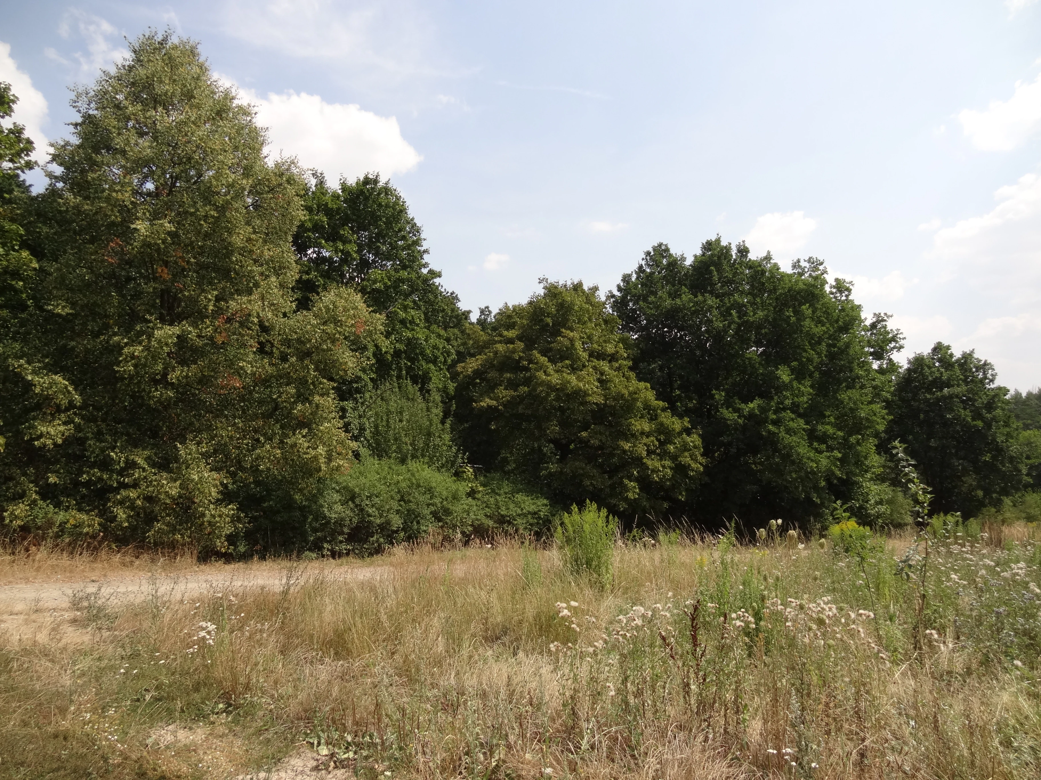
A wide shot of a deciduous forest edge bordering a dry grassy meadow under a partly cloudy sky.
A summer view of the forest edge and meadow within the Škvorecká obora, Králičina Nature Park.

Přírodní park Škvorecká obora, Králičina history and protected-area timeline

The historical layers preserved in the park span several centuries. The wooded core of the area originated as a walled game reserve (obora) for deer and fallow deer, established at the turn of the 17th and 18th centuries by the Liechtenstein family, then lords of the Škvorec estate. The surviving entrance gate bearing the Liechtenstein coat of arms is the most directly visible reminder of this enclosure's aristocratic origins.

The stream valley, however, was significant to local settlement and power much earlier. On a spur above where an unnamed tributary joins the Výmola, the terrain still shows the remains of the medieval hillfort of Skara, indicating that the defensible overlooks in this valley system were already in use in the Middle Ages. In the same area, the parish and settlement history of the region left further traces, including the site of the former medieval village of Lhota to the north.

The 19th century is represented in the landscape through infrastructure and folk memory alike. The two-arch stone bridge spanning the Výmola at the southwestern edge of the park dates to 1842 and is sometimes mistakenly described as Romanesque, an attribution the park's own heritage materials correct. Small devotional and folk features, such as the Marian image attached to the so-called Mariánský dub (a memorial tree in the heart of the park) and the Květnická studánka spring, reflect the rural religious customs of the surrounding countryside.

Formal protection came relatively recently. In February 2009, the Central Bohemian regional council issued a decree establishing the area as a přírodní park, recognizing the joint natural, landscape, and cultural value of the surviving Škvorecká obora woodland and the Výmola floodplain.

Přírodní park Škvorecká obora, Králičina landscape and geographic character

The landscape of Přírodní park Škvorecká obora – Králičina is shaped by the transition between the broad upland of the Pražská plošina and the locally incised valley of the Výmola stream. At its northern edge, the park is clearly bounded by the busy I/12 corridor linking Prague and Kolín, which creates a sharp boundary between transport infrastructure and forest.

Inland from that boundary, the terrain is gently rolling, with the Výmola cutting a noticeable valley along the southeastern part of the protected area. This valley is the defining geomorphological feature of the park: its floodplain, banks, and slopes carry most of the natural value identified in the protection decree, and they also concentrate the area's scenic qualities, alternating between dense woodland and more open ground where the valley widens.

The northern and western portions of the park are dominated by the wooded plateau above the stream, where the long-established forest of Škvorecká obora creates a continuous canopy. Viewpoints such as the spur above the confluence of the unnamed tributary with the Výmola, where the medieval Skara hillfort once stood, break the otherwise enclosed forest character and offer relief from the otherwise low-relief Bohemian landscape.

Přírodní park Škvorecká obora, Králičina ecosystems, habitats, and plant life

The park's natural character is defined by the overlap between an old lowland forest and a relatively intact stream floodplain, a combination that is increasingly rare on the heavily urbanized outskirts of Prague. The dense vegetation of the Škvorecká obora woodland is the larger ecological unit, while the narrower, narrower, hydrologically active corridor of the Výmola functions as the park's ecological spine.

Habitats here include floodplain forest, slope woodland on the Výmola valley sides, and patches of more open or transitional vegetation associated with the floodplain margins. The wooded area shows strong regeneration and overgrowth, consistent with its long history as enclosed hunting ground with centuries of reduced disturbance from agriculture.

Among recorded species of conservation interest, krtičník křídlatý (winged figwort) is specifically highlighted in the park's literary sources as an example of the rare flora the protected status aims to safeguard. The combination of closed forest and active stream creates a varied microclimate pattern, supporting different communities along the valley floor, on its slopes, and across the elevated wooded plateau.

Přírodní park Škvorecká obora, Králičina wildlife and species highlights

Wildlife character in the park is closely tied to its history as a former aristocratic game reserve. The very word obora indicates an enclosed, managed area that once hosted deer (jelen lesní) and fallow deer (daněk evropský), and although the modern protected area is not primarily a game reserve, the long continuity of forest with limited agricultural disturbance has left a habitat mosaic that continues to support larger forest fauna typical of Central Bohemian lowland woodlands.

The local place-name Králičina itself preserves an older faunal memory, reflecting the once abundant population of wild rabbits (králík divoký) in the area, and serves as a reminder that the park's habitats have historically hosted distinctive small-mammal communities. The floodplain and stream of the Výmola add amphibian, invertebrate, and aquatic habitats typical of small Bohemian lowland watercourses.

The park's modest size and strong forest cover mean that wildlife is best experienced indirectly: through tracks, browsing signs, and sound, rather than large open sightings. Its relatively undisturbed character, in combination with its connection to the much larger Klánovický forest to the southeast, makes it an important local refuge and movement corridor for forest species on the edge of Prague.

Přírodní park Škvorecká obora, Králičina conservation status and protection priorities

From a conservation standpoint, Přírodní park Škvorecká obora – Králičina is significant less for its size than for its condition and position. It protects one of the better-preserved forest floodplain complexes on the eastern edge of the Prague metropolitan area, an area where the natural landscape has otherwise been heavily reduced by agriculture, roads, and suburban expansion.

The protected designation explicitly ties conservation value to two interacting features: the preserved floodplain of the Výmola and the adjacent Škvorecká obora forest. Together, these provide hydrological, edaphic, and biological continuity that might otherwise be lost in the surrounding peri-urban landscape. The park's role as a northern anchor of the larger Klánovický forest complex amplifies this conservation importance at the regional level.

Although national nature parks in the Czech Republic (přírodní parky) are a regional landscape-protection category rather than a strict nature reserve designation, this intensification of protection brings planning controls on land use, helping to keep the forest canopy, valley hydrology, and rare plant habitats such as those of krtičník křídlatý intact as suburban pressure from Prague and Úvaly continues to grow along the park's edges.

Přírodní park Škvorecká obora, Králičina cultural meaning and human context

The park carries a layered cultural identity that reflects both aristocratic and rural Bohemian traditions. Its origins as a Liechtenstein hunting enclosure tie it to the wider history of the Škvorec estate and to the role of noble families in shaping lowland Bohemian landscapes through game reserves, avenues, and managed woodlands.

Rural and religious folk culture is visible at a smaller scale in features such as the Květnická studánka spring, the memorial tree known as Mariánský dub, and the way the park still incorporates the field paths and historic routes that once linked farms and forests in this part of Central Bohemia. The medieval hillfort of Skara adds a deeper, pre-aristocratic layer, reminding visitors that the Výmola valley was significant long before the obora was established.

These tangible features are not merely incidental: they help explain the place-names that survive in local memory, including Králičina, and they connect contemporary nature protection to a long timeline of human shaping of the landscape around Prague.

Top sights and standout views in Přírodní park Škvorecká obora, Králičina

The strongest highlights of the park include the Výmola valley floodplain, the centuries-old forest of Škvorecká obora, and the surviving Liechtenstein entrance gate with its coat of arms, all within a single short walk. The combination of medieval earthworks at Skara, an 1842 stone bridge over the Výmola, and the Květnická studánka spring adds uncommon cultural density for a protected area of this modest scale.

The park's position as the northwestern neighbor of the larger Klánovický forest also makes it a gateway for visitors interested in the broader green corridor along Prague's eastern rim, and its rare flora, particularly krtičník křídlatý, gives it a botanical interest that complements its historical and landscape appeal.

Best time to visit Přírodní park Škvorecká obora, Králičina

The park's character shifts with the seasons in ways that reward repeat visits rather than dictating a single best moment. Spring brings fresh green contrast between the dense forest canopy and the active floodplain of the Výmola, and this is also when Květnická studánka and the broader Mostek přes Výmolu trail network feel most alive.

Late spring and early summer tend to highlight the dense flower layers in the forest understory, which is also when rare plant species such as krtičník křídlatý are most visible to careful observers. Autumn produces strong color contrast across the wooded plateau and the valley slopes, as well as good conditions for reading the terrain and locating the traces of Skara and the Liechtenstein gate beneath the open canopy.

Monthly climate preview

Long-term monthly temperature ranges and precipitation averages recorded at reference elevation

Annual Temperature and Precipitation Normals for Přírodní park Škvorecká obora – Králičina

Historical data from 1991 to 2020 outlines the measured temperature and precipitation rhythm across twelve distinct months at a representative park coordinate. Reviewing the complete monthly profile provides deeper insight into long-term climate variations and annual averages.
Annual mean9 °C
-2 °C20 °C
Jan-2°
Feb-1°
Mar
Apr
May14°
Jun18°
Jul20°
Aug19°
Sep14°
Oct
Nov
Dec-1°
Warmest month
July

19.8 °C

Coolest month
January

-2.5 °C

Wettest month
July

2.7 mm/day

Driest month
April

1.2 mm/day

Park location guide

Geography guide, regional context, and park location map for Přírodní park Škvorecká obora, Králičina

Přírodní park Škvorecká obora, Králičina park geography, regions, and map view in Czechia

Understand where Přírodní park Škvorecká obora, Králičina sits in Czechia through a broader geographic reading of the surrounding landscape, nearby location context, and its mapped position within the national park landscape.

How Přírodní park Škvorecká obora, Králičina fits into Czechia

Czech Republic is a landlocked Central European country with a population of approximately 10.9 million people. The nation was established as an independent state on January 1, 1993, following the dissolution of Czechoslovakia. Its capital and largest city is Prague, with other major urban centers including Brno, Ostrava, Plzeň, and Liberec.

Wider geography shaping Přírodní park Škvorecká obora, Králičina in Czechia

The Czech Republic is a landlocked country in Central Europe. It is bordered by Germany to the west, Austria to the south, Poland to the northeast, and Slovakia to the southeast. The landscape is predominantly hilly, with the territory covering 78,871 square kilometers.

Map view of Přírodní park Škvorecká obora, Králičina

Use this park location map to pinpoint Přírodní park Škvorecká obora, Králičina in Czechia, understand its exact geographic position, and read its mapped placement within the surrounding landscape more clearly.

Pigeon | © OpenStreetMap contributors

Location context for Přírodní park Škvorecká obora, Králičina

Středočeský kraj

Visual exploration of floodplain habitats, stream valleys, and historic forest terrain

Přírodní park Škvorecká obora – Králičina Photos and Protected Area Scenery

Visual records capture the distinctive lowland stream valley and dense woodland canopy that define Přírodní park Škvorecká obora – Králičina. Examining these protected area views reveals the rolling topography, historical stone structures, and preserved natural habitats across the central Bohemian landscape.

A wide shot of a deciduous forest edge bordering a dry grassy meadow under a partly cloudy sky.

Park atlas

Compare adjacent Central Bohemian reserves and surrounding regional nature parks

Explore Protected Areas and Parks Near Přírodní park Škvorecká obora – Králičina

Browsing other protected areas near Přírodní park Škvorecká obora – Králičina reveals connected stream valleys and lowland forest corridors across the eastern Prague plateau. Comparing adjacent regional landscapes expands geographic context beyond a single protected enclosure into broader Central Bohemian terrain.
A soft watercolor painting of a rural landscape with light green meadows and clusters of trees under a pale, washed-out sky.
Protected landscapePrague
About 7.3 km away#1 closest

West

Přírodní park Říčanka: Protected Landscape and Geographic Map of Eastern Prague

An analysis of rural corridors, aquatic systems, and forest terrain.

Přírodní park Říčanka preserves an extensive rural ribbon of meadows, arable fields, and woodland patches on the eastern edge of Prague. This structured overview details the park's topography, its historic fishpond chain along the Říčanský potok, and the various natural monuments that characterize this protected Czech landscape.

Area
4 km²
Established
1984
Relief
Lowland
Climate
Temperate
A watercolor painting showing a panoramic landscape with a rocky quarry ledge in the foreground, green hills in the midground, and soft, pastel colored rolling hills in the background.
Natural monumentPrague
About 8.5 km away#2 closest

West

Rohožník, lom v Dubči: Geological Natural Monument and Protected Landscape in Prague

Analyzing the Ordovician quartzite and tectonic rock exposures of the Prague Plateau

Rohožník, lom v Dubči serves as a crucial natural monument in the Prague region, protecting abandoned quarries that showcase clear M-shaped tectonic folds and thick quartzite deposits. This site acts as a living laboratory for geological history, connecting archaeological finds with dry grassland communities in an otherwise suburban-agricultural landscape on the edge of the capital.

Area
0.034 km²
Established
1988
IUCN
III
Relief
Upland
A soft watercolor painting of a winding stream moving through green meadows with distant rolling hills and a light, misty atmosphere.
Natural monumentPrague
About 12 km away#3 closest

West

Meandry Botiče Natural Monument: Mapped Geography and Protected Stream Landscapes in Prague

Analyzing the ecological boundaries and riparian terrain of the Botič stream corridor

Meandry Botiče represents a significant natural monument in Prague, distinguished by its pronounced stream meanders and dense bankside vegetation. This site offers deep insights into urban conservation, documenting the delicate balance between native riparian flora and the pressures of encroaching residential districts within a managed protected environment.

Area
0.067 km²
Established
1968
IUCN
III
Relief
Lowland
A pale, soft-toned watercolor painting of a rolling landscape featuring a stream in the foreground, scattered trees in the midground, and faint mountains in the distant background.
Protected landscapePraha
About 13 km away#4 closest

Southwest

Přírodní park Botič-Milíčov: Protected Landscape, River Valley, and Forest Map

A preserved green refuge featuring meandering streams and pond networks near Praha.

Přírodní park Botič-Milíčov stands as a significant protected landscape in Praha, defined by the seasonal flooding of the Botič and Pitkovický streams. The park hosts alluvial forests, a series of historic ponds, and archaeological traces of ancient mills. Through map-based exploration, identify the diverse terrain that includes rocky outcrops at Pitkovická stráň and extensive broadleaf woodlands on the edge of urban housing developments.

Area
8.24 km²
Established
1984
Relief
Lowland
Climate
Temperate
A soft, minimalist watercolor painting showing a green treeline against a pale pink and white background, suggestive of wetlands or ponds.
Natural monumentPrague
About 13 km away#5 closest

Southwest

Milíčovský les a rybníky: Protected Landscape and Wetland Map in Prague, Czech Republic

Natural monument geography and forest-wetland habitat atlas

Milíčovský les a rybníky represents a core natural monument in southern Prague, featuring a mature deciduous forest integrated with a managed system of ponds. This protected area serves as a critical refuge for rare wetland and woodland species. Use the mapping tools to trace the terrain, from the dense oak-hornbeam canopy to the extensive reedbeds and aquatic environments that define this unique urban-edge landscape.

Area
1.047 km²
Established
1991
IUCN
III
Relief
Upland
A soft watercolor painting of a green landscape featuring a small body of water, rolling hills, and trees, painted in a minimalist style on a white background.
Protected landscapePrague
About 14 km away#6 closest

West

Hostivař-Záběhlice Nature Park: Protected Landscape and Mapped Prague Geography

River valleys and reservoir terrain within the capital city.

Hostivař-Záběhlice Nature Park represents a vital natural zone in Prague, characterized by the mature forests and meandering river paths along the Botič stream. This record highlights the park's geographic composition, including its reservoirs, lowland forest patches, and its function as a preserved natural corridor within the city.

Area
4.23 km²
Established
1990
Relief
Lowland
Climate
Temperate
A soft, horizontal watercolor painting showing a green meadow with scattered bushes, distant rolling hills, and a pale, warm-toned sky.
Natural monumentStředočeský kraj
About 17 km away#7 closest

Northeast

Slatinná louka u Velenky Natural Monument: Geography and Protected Meadow Landscape

Protected grassland terrain in the Středočeský kraj

Slatinná louka u Velenky preserves a rare fragment of alkaline fen meadow within the Czech lowlands. As a designated natural monument and part of the Natura 2000 network, it functions as a crucial habitat buffer. This atlas entry provides insight into the park's flat lowland geography and its role in maintaining regional biodiversity across the Polabí plain.

Area
0.038 km²
Established
2014
IUCN
IV
Relief
Lowland
Nature reservePrague
About 19 km away#8 closest

West

V hrobech Nature Reserve: A Protected Botanical Island within the Urban Landscape of Prague

Rare dry-grassland habitats in the Kamýk district

V hrobech is a designated nature reserve in Prague featuring 1.3 hectares of southeast-facing slopes and species-rich grassland. This site is home to rare thermophilic plants and represents an important example of intensive conservation management in an urban environment. Its protected boundaries connect with local forest fragments to maintain ecological value amidst the residential developments of Lhotka and Libuš.

Area
0.013 km²
Established
1988
IUCN
IV
Relief
Lowland

Common questions about visiting, size, designation, and location context for Přírodní park Škvorecká obora, Králičina

Přírodní park Škvorecká obora, Králičina FAQs for park facts, access, geography, and protected area context

Find quick answers about Přírodní park Škvorecká obora, Králičina, including protected-area facts, park geography, trail and visitor context, and how the park fits into its surrounding country and regional landscape.
MoriAtlas Explorer

Continue Your Protected Areas Search Across the Global Atlas

Deepen your exploration by continuing the structured search for national parks and protected areas worldwide. Utilize the comprehensive filtering capabilities to compare different conservation landscapes and refine your understanding of global park geography. Discover more about the distribution and characteristics of protected natural areas.

Global natural geography