

Mori Atlas logo
Natural monumentSlatinná louka u Velenky

Understanding the mapped boundaries and alkaline meadow geography of the Středočeský kraj region

Slatinná louka u Velenky: A Significant Natural Monument and Lowland Meadow Protected Area

Slatinná louka u Velenky serves as a vital natural monument in the Středočeský kraj of the Czech Republic, preserving rare Molinia-rich alkaline grasslands within the expansive Polabí lowland. This protected area functions as a critical component of the local ecological network, maintaining essential habitat connectivity for base-rich meadow species. Our atlas maps the delicate hydrology and flat terrain that define this protected landscape, offering a clear view of its conservation value.

alkaline fen meadowMolinia meadowbezkolencová loukalowland grasslandNatura 2000natural monument
A flat vector illustration of a valley with a river in the foreground, pine trees, a waterfall flowing from rocky cliffs in the background, and a bright sun in the sky.

Slatinná louka u Velenky

Natural monument

Park overview

Structured park overview, official facts, and landscape profile for Slatinná louka u Velenky

Slatinná louka u Velenky park facts, protected area profile, and essential visitor context

Review the core facts for Slatinná louka u Velenky, including designation, size, terrain, visitor scale, habitats, and operating context in one park-focused overview.

About Slatinná louka u Velenky

Slatinná louka u Velenky sits in the heart of the Central Bohemian lowland, the Polabí, where for centuries the flat floodplain of the Elbe River shaped a mosaic of wet meadows, riverside forests, and small stream valleys. Within this largely agricultural landscape, very few fragments of the original species-rich grassland have survived, and the protected meadow at Hradištko is one of those increasingly precious remnants.

Ecologically, the site is anchored on bezkolencové louky, the Czech term for Molinia caerulea-dominated alkaline meadows developed over calcareous, peaty, or heavy silty-clay soils. These habitats form a transitional zone between dry grasslands and true peatlands, supporting specialized plant communities that depend on persistently high groundwater levels and a low intensity of disturbance. Such meadows were once widespread across warm lowlands of Central Europe but have retreated dramatically under drainage, fertilization, and conversion to arable land.

The site's geographic position, immediately adjacent to the Velenský potok stream on its western edge, helps sustain the wet conditions that the meadow communities require. The protected area also functions as a buffer against further hydrological disturbance from surrounding farmland, helping stabilize the local water regime.

Management and legal context add another layer of importance. Declared as a přírodní památka in 2014, the area sits in overlap with an evropsky významná lokalita (Site of Community Importance) within the Natura 2000 network. This formal recognition at both the Czech and EU levels reflects the meadow's importance as habitat for protected plant species that find refuges in only a handful of sites scattered across the Czech Republic.

Quick facts and research context for Slatinná louka u Velenky

Slatinná louka u Velenky is a Czech přírodní památka, the country's designation for a smaller-scale natural monument. It lies in the village of Hradištko in the Nymburk District of the Středočeský kraj and was designated by the Regional Authority of the Central Bohemian Region on 21 October 2014.

The site covers approximately 3.83 hectares at an elevation of about 182 to 183 meters above sea level and overlaps fully with a Natura 2000 Site of Community Importance. It sits directly next to the national natural monument of the same name, and the two protected units together form a connected conservation complex focused on alkaline fen meadows in the Polabí region.

Protection and recognition

Documented terrestrial protection scope and Natura 2000 registry data

Slatinná louka u Velenky Protection Status and International Recognition

Slatinná louka u Velenky features documented terrestrial protection status within official European ecological frameworks. Natura 2000 recognition sources outline the recorded boundary context and administrative designation data for this protected area.

International recognition

Protection details

Protection scope
Terrestrial
Transboundary protection
No
Park context

Deeper park guide and search-rich context for Slatinná louka u Velenky

Slatinná louka u Velenky history, landscape, wildlife, and travel context

Explore Slatinná louka u Velenky through its history, landscape character, ecosystems, wildlife, conservation priorities, cultural context, and seasonal travel timing in a structured park guide built for atlas discovery and search intent.

Why Slatinná louka u Velenky stands out

The site is best known for preserving a small but ecologically valuable fragment of bezkolencové louky, a type of calcium-rich, Molinia-dominated fen meadow that has become exceedingly rare in the intensively farmed Czech lowlands. Its overlap with the Natura 2000 network and its function as adjacent habitat for two European-protected species further define the site's conservation identity. It is equally notable for its close pairing with the neighboring national natural monument of the same name, creating a two-tiered protection mosaic around a single ecological system. This combination of a přírodní památka and a národní přírodní památka around the same meadow complex is a distinctive feature of the area's conservation history.
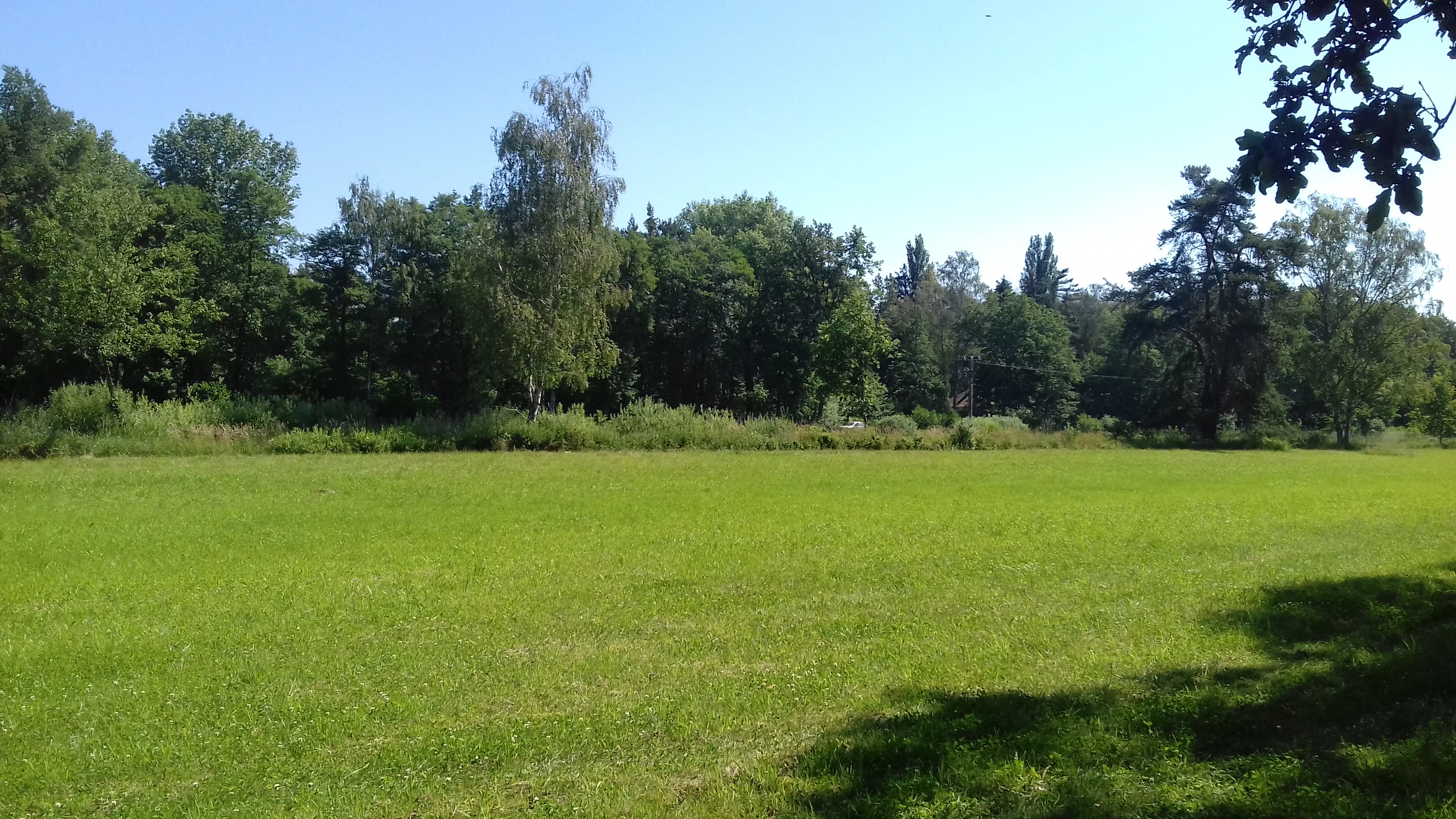
A wide view of a bright green meadow bordered by a line of mature green trees under a clear blue sky.
A view of the protected meadow at Slatinná louka u Velenky in the Czech Republic.

Slatinná louka u Velenky history and protected-area timeline

The conservation history of Slatinná louka u Velenky is closely tied to the broader recognition of the Polabí's vanishing meadow heritage. Although the area's ecological importance had been understood for some time by botanists studying the Czech fen-meadow flora, formal protection at this specific site came relatively recently.

On 21 October 2014, the Regional Authority of the Středočeský kraj (Central Bohemian Region) designated the locality as a přírodní památka, a national-level natural monument designation reserved for smaller, scientifically or aesthetically significant areas. The new legal status was deliberately placed in full overlap with the existing evropsky významná lokalita of the same name, harmonizing the site's national and European protection frameworks.

The designation also acknowledged the de facto relationship with the adjacent národní přírodní památka (national nature monument) of the same name, which carries stronger protection for core populations of rare species. Together, these two designations represent a step in a wider strategy to safeguard fragmented alkaline meadow complexes across the Central Bohemian Region.

Slatinná louka u Velenky landscape and geographic character

The landscape around Slatinná louka u Velenky is characteristic of the Polabí, the wide, flat lowland that flanks the middle course of the Labe (Elbe) River in central Bohemia. The surrounding terrain is overwhelmingly agricultural, dominated by large, open fields and only small remnants of natural or semi-natural vegetation along watercourses and field margins.

Within this setting, the protected meadow occupies a very gently undulating patch of plain at just 182 to 183 meters above sea level. To its west runs the Velenský potok, a small local watercourse whose drainage influence helps shape the hydrology of the meadow. The brook adds linear structure to the otherwise open landscape and serves as a partial boundary of the protected area.

The meadow itself is essentially flat, with no dramatic landforms, but its subtle microtopography influences how water moves across the surface. Slightly lower-lying, persistently waterlogged patches support the most sensitive fen-meadow vegetation, while the edges host slightly drier transitions into adjacent habitats. The resulting visual impression is of an unobtrusive but ecologically rich grassland set within a broad, cultivated plain.

Slatinná louka u Velenky ecosystems, habitats, and plant life

The defining natural value of Slatinná louka u Velenky lies in its bezkolencové louky, Molinia-rich alkaline meadows that develop on calcareous, peat-forming, or clay-rich mineral soils. These meadows are dominated by tufted grass species, especially bezkolenec (Molinia caerulea), which gives the habitat type its Czech name, alongside a diverse mix of sedges, orchids, and other small herbs adapted to mineral-rich, base-saturated conditions.

Such habitats occupy a narrow ecological niche. They require consistent soil moisture, low nutrient availability, and limited disturbance to persist over time. Even small changes in land use, drainage, or fertilization can rapidly shift the vegetation toward denser, more competitive grasses or shrubs, causing the characteristic flora to disappear. This sensitivity is what makes surviving fragments, including the meadow at Hradištko, so important for biodiversity conservation at the regional scale.

The site's overlap with a Natura 2000 evropsky významná lokalita underscores the recognized pan-European importance of these habitats. The Czech Republic, like other Central European countries, has lost the majority of its former Molinia-rich meadows, and the few remaining patches are now key steppingstones for the survival of their associated flora and fauna.

Slatinná louka u Velenky wildlife and species highlights

While the most prominent conservation interest at Slatinná louka u Velenky is botanical, the meadow's structure and management regime create conditions that benefit a range of associated fauna. Alkaline Molinia meadows of this kind are known to support diverse invertebrate communities, including pollinators such as bees, butterflies, and moths that depend on the meadow's rich floral resources.

The site's reptile fauna, characteristic of similar Czech lowland meadows, can include species such as the sand lizard and slow worm, which favor sunny, structured grassland with patches of bare ground and low scrub. Small mammals typical of grassy lowlands, such as voles and shrews, also inhabit the area, and these in turn support predators such as owls, foxes, and weasels that move between the meadow and surrounding agricultural land.

Birds associated with open wet grasslands, including various pipits, wheatears, and wetland-edge passerines, may use the site for foraging or breeding, particularly where the meadow borders the Velenský potok. Overall, the fauna follows the patterns typical of small, intensively managed lowland nature reserves, with the invertebrate and plant layers carrying the highest conservation value.

Slatinná louka u Velenky conservation status and protection priorities

Slatinná louka u Velenky represents an important entry point for understanding how small protected meadow fragments fit into larger conservation strategies in the Czech lowlands. The site is declared as a přírodní památka, providing protection against damaging land-use changes such as plowing, drainage, or intensive fertilization, which have historically been the greatest threats to alkaline fen meadows in this region.

Equally significant is the site's overlap with a designated evropsky významná lokalita, a Site of Community Importance under the EU Habitats Directive. This European-level recognition connects the meadow into the broader Natura 2000 network and obliges national authorities to maintain its favorable conservation status for the species and habitat types for which it was designated.

The site's proximity to the national nature monument of the same name adds a further conservation dimension. Because the two protected units share the same ecological system but have different protection regimes, they together form a layered safety net for rare species associated with these meadows. Beyond its intrinsic ecological value, the site therefore serves as a practical example of how complementary national and European designations can reinforce protection of highly localized and sensitive habitats.

Slatinná louka u Velenky cultural meaning and human context

The area around Hradištko lies within the historically agricultural heartland of the Central Bohemian Region, where farming traditions have shaped the landscape for centuries. The survival of small, species-rich meadows amid intensive agriculture reflects a long, if uneven, coexistence between human land use and natural processes.

The Czech concept of slatinná louka, literally 'muddy' or 'marl' meadow, itself reflects folk understanding of the wet, mineral-rich soils that define these grasslands. Local communities historically distinguished several types of meadowland based on soil moisture, productivity, and species composition, an awareness that has gradually faded as land use has standardized. Protected sites such as Slatinná louka u Velenky today preserve both the natural features and an underlying cultural memory of this older, more nuanced pastoral landscape.

Top sights and standout views in Slatinná louka u Velenky

The principal highlight of the site is its bezkolencové louka, a calcium-rich Molinia meadow that ranks among the most threatened habitat types in the Czech lowlands. The site's dual designation as a přírodní památka and Natura 2000 Site of Community Importance gives it both national and European-level protection, an arrangement that is rare for such a small area.

A second distinguishing feature is the meadow's direct functional relationship to the neighboring národní přírodní památka of the same name, where Europe's protected fen meadow species are concentrated. Together, the two sites form an unusually compact conservation complex in the heart of the Polabí agricultural landscape.

Best time to visit Slatinná louka u Velenky

The preferred period for experiencing temperate Central European fen meadows like Slatinná louka u Velenky is late spring through early summer, roughly from mid-May to early July. During this window, the meadow's herbaceous layer is at its richest, with flowering Molinia, sedges, and associated meadow herbs producing a varied and colorful display.

Late summer visits, from mid-July into early September, instead showcase the golden tones and seed heads of mature bezkolenec stands, when the meadow's structural character is most pronounced. Wet conditions can make the low-lying terrain muddy in early spring and after heavy rain, while winter visits generally offer less botanical interest and may coincide with frozen ground and suppressed vegetation.

Monthly climate preview

Long-term representative point measurements tracking monthly temperature and precipitation cycles

Slatinná louka u Velenky Climate Normals and Annual Temperature Rhythm

Representative coordinate measurements record the annual temperature progression from winter lows through summer highs alongside steady monthly precipitation totals at Slatinná louka u Velenky. Examining the comprehensive monthly climate profile reveals complete statistical distributions across all twelve modeled periods for this protected location.
Annual mean9 °C
-2 °C20 °C
Jan-2°
Feb-1°
Mar
Apr
May14°
Jun18°
Jul20°
Aug19°
Sep14°
Oct
Nov
Dec-1°
Warmest month
July

19.8 °C

Coolest month
January

-2.5 °C

Wettest month
July

2.7 mm/day

Driest month
April

1.2 mm/day

Park location guide

Geography guide, regional context, and park location map for Slatinná louka u Velenky

Slatinná louka u Velenky park geography, regions, and map view in Czechia

Understand where Slatinná louka u Velenky sits in Czechia through a broader geographic reading of the surrounding landscape, nearby location context, and its mapped position within the national park landscape.

How Slatinná louka u Velenky fits into Czechia

Czech Republic is a landlocked Central European country with a population of approximately 10.9 million people. The nation was established as an independent state on January 1, 1993, following the dissolution of Czechoslovakia. Its capital and largest city is Prague, with other major urban centers including Brno, Ostrava, Plzeň, and Liberec.

Wider geography shaping Slatinná louka u Velenky in Czechia

The Czech Republic is a landlocked country in Central Europe. It is bordered by Germany to the west, Austria to the south, Poland to the northeast, and Slovakia to the southeast. The landscape is predominantly hilly, with the territory covering 78,871 square kilometers.

Map view of Slatinná louka u Velenky

Use this park location map to pinpoint Slatinná louka u Velenky in Czechia, understand its exact geographic position, and read its mapped placement within the surrounding landscape more clearly.

Pigeon | © OpenStreetMap contributors

Location context for Slatinná louka u Velenky

Středočeský kraj
Recorded earthquake history

Review the Historical Earthquake Catalogue for Slatinná louka u Velenky

Access a structured, location-based collection of seismic records associated with the area surrounding Slatinná louka u Velenky. The MoriAtlas catalogue presents event dates, epicentre distances, and magnitudes to support clear regional geographic inquiry.

Slatinná louka u Velenky Earthquake History

Catalogued events

2 events

Strongest magnitude

Magnitude 3.7

Most recent event

Oct 22, 1987

This history includes earthquakes recorded inside the park or within 50 km of its borders

Visual exploration of rare lowland fen meadows and local habitat terrain

Slatinná louka u Velenky Photos and Protected Landscape Scenery

Photographic documentation reveals the flat lowland terrain, Molinia grasslands, and delicate wetland habitats that define Slatinná louka u Velenky. Visual reference material provides direct insight into the protected environment and rare vegetation communities of the Central Bohemian region.

A wide view of a bright green meadow bordered by a line of mature green trees under a clear blue sky.

Park atlas

Compare regional lowland grasslands, fen meadows, and surrounding conservation landscapes

Explore Protected Areas and Parks Near Slatinná louka u Velenky

Discover related protected areas situated across the surrounding Central Bohemian agricultural region and Elbe lowland. Comparing these neighboring habitats reveals broader ecological patterns and regional grassland connectivity beyond Slatinná louka u Velenky.
A horizontal watercolor painting of a serene wetland scene with birch trees, calm water reflecting the sky, and grassy shores.
Natural monumentStředočeský kraj
6.9 km away#1 closest

Southeast

Milčice Natural Monument: A Protected Wetland Sanctuary in the Středočeský kraj

Rare calcareous spring systems and lowland fen ecology

Milčice serves as a regionally important natural monument in the Středočeský kraj, protecting a distinct set of tufa-forming springs. This site offers a rare glimpse into the specialized ecology of mineralized lowland wetlands, providing a stark contrast to the surrounding agricultural terrain of the Middle Elbe Table.

Area
0.041 km²
Established
2017
IUCN
III
Relief
Lowland
A soft, light-filled watercolor painting of a rolling Czech landscape featuring deciduous trees, grassy meadows, and distant hills.
Natural monumentStředočeský kraj
16 km away#2 closest

Northwest

Slepeč Natural Monument: Protected Woodland Geography in the Central Bohemian Region

A rare botanical sanctuary in the Jizera basin.

The Slepeč natural monument represents a concentrated area of high botanical importance, shielding a remnant oak-hornbeam woodland from surrounding cultivation. Located in the Středočeský kraj, this site is renowned for housing diverse orchid species, including the lady's slipper, within a specialized microclimate found in the lowland terrain. Its protected status offers a unique look at forest conservation in an agricultural heartland.

Area
0.088 km²
Established
1984
IUCN
IV
Relief
Upland
A watercolor illustration depicting a panoramic landscape with a golden meadow in the foreground and soft green hills in the distance.
Protected landscapeStředočeský kraj
About 17 km away#3 closest

Southwest

Přírodní park Škvorecká obora, Králičina: Protected Landscape and Regional Geography

Natural terrain and historic forest near the Prague boundary

Přírodní park Škvorecká obora, Králičina preserves a layered cultural and natural landscape characterized by the Výmola stream floodplain. The area functions as a vital forest habitat on the eastern edge of the Prague Plateau, integrating rare botanical sites with historical remnants of a centuries-old game enclosure.

Established
2009
Relief
Lowland
Climate
Temperate
Access
Easy access
A soft watercolor painting of a rural landscape with light green meadows and clusters of trees under a pale, washed-out sky.
Protected landscapePrague
About 24 km away#4 closest

Southwest

Přírodní park Říčanka: Protected Landscape and Geographic Map of Eastern Prague

An analysis of rural corridors, aquatic systems, and forest terrain.

Přírodní park Říčanka preserves an extensive rural ribbon of meadows, arable fields, and woodland patches on the eastern edge of Prague. This structured overview details the park's topography, its historic fishpond chain along the Říčanský potok, and the various natural monuments that characterize this protected Czech landscape.

Area
4 km²
Established
1984
Relief
Lowland
Climate
Temperate
A watercolor painting showing a panoramic landscape with a rocky quarry ledge in the foreground, green hills in the midground, and soft, pastel colored rolling hills in the background.
Natural monumentPrague
About 25 km away#5 closest

Southwest

Rohožník, lom v Dubči: Geological Natural Monument and Protected Landscape in Prague

Analyzing the Ordovician quartzite and tectonic rock exposures of the Prague Plateau

Rohožník, lom v Dubči serves as a crucial natural monument in the Prague region, protecting abandoned quarries that showcase clear M-shaped tectonic folds and thick quartzite deposits. This site acts as a living laboratory for geological history, connecting archaeological finds with dry grassland communities in an otherwise suburban-agricultural landscape on the edge of the capital.

Area
0.034 km²
Established
1988
IUCN
III
Relief
Upland
A watercolor painting showing a panoramic view of a wetland area with reeds in the foreground and a forested ridge in the background.
Protected landscapeMladá Boleslav District
About 27 km away#6 closest

North

Přírodní park Chlum: Exploring the Geography of a Protected Czech Woodland Ridge

Mladá Boleslav District protected landscape analysis

Examine the structural character of Přírodní park Chlum, an asymmetric horst ridge in the Czech Republic that serves as a vital ecological corridor. This protected landscape preserves rare forest communities and geological features, providing essential habitat continuity across the surrounding agricultural lowlands of the Mladá Boleslav District.

Area
13.19 km²
Established
2000
Relief
Upland
Climate
Temperate
A soft watercolor painting of a winding stream moving through green meadows with distant rolling hills and a light, misty atmosphere.
Natural monumentPrague
About 29 km away#7 closest

Southwest

Meandry Botiče Natural Monument: Mapped Geography and Protected Stream Landscapes in Prague

Analyzing the ecological boundaries and riparian terrain of the Botič stream corridor

Meandry Botiče represents a significant natural monument in Prague, distinguished by its pronounced stream meanders and dense bankside vegetation. This site offers deep insights into urban conservation, documenting the delicate balance between native riparian flora and the pressures of encroaching residential districts within a managed protected environment.

Area
0.067 km²
Established
1968
IUCN
III
Relief
Lowland
A horizontal watercolor painting depicting a soft landscape with green hills, light forest foliage, and a water body in a muted, warm color palette.
Protected landscapeMladá Boleslav District
About 29 km away#8 closest

Northeast

Přírodní park Čížovky: Geographic Overview of the Protected Landscape in Mladá Boleslav District

Mapping wetlands, aquatic ecosystems, and rural terrain

Přírodní park Čížovky serves as a significant protected landscape in the Mladá Boleslav District. It features a dense mosaic of ponds, marshes, and orchards. Explore the mapped boundaries of this terrain, ranging from the Křesovský potok valley to the elevated Křemenice ridge, showcasing a classic Central Bohemian ecological heritage.

Area
386 km²
Established
1998
Relief
Upland
Climate
Temperate

Common questions about visiting, size, designation, and location context for Slatinná louka u Velenky

Slatinná louka u Velenky FAQs for park facts, access, geography, and protected area context

Find quick answers about Slatinná louka u Velenky, including protected-area facts, park geography, trail and visitor context, and how the park fits into its surrounding country and regional landscape.
MoriAtlas Explorer

Continue Your Protected Areas Search Across the Global Atlas

Deepen your exploration by continuing the structured search for national parks and protected areas worldwide. Utilize the comprehensive filtering capabilities to compare different conservation landscapes and refine your understanding of global park geography. Discover more about the distribution and characteristics of protected natural areas.

Global natural geography