

Mori Atlas logo
Natural monumentSluňáky

Explore the unique quartzite boulder field and historical landscape of this Czech protected area.

Sluňáky Natural Monument: A Geologic Relict in the Foothills of the Doupovské Hory

(Přírodní památka Sluňáky)

Sluňáky stands as a significant natural monument in the Ústecký kraj region, preserved for its rare collection of weathered quartzite boulders. Located at the northeastern edge of the Doupovské hory, this protected territory offers a unique window into Tertiary geological processes and the history of regional quartzite extraction. The site provides essential context for the transition between volcanic mountain ranges and the surrounding basin landscape.

geological monumentquartzite boulderssmall protected areaCzech natural monumentDoupovské hory foothillsTertiary geology

Sluňáky

Natural monument

Park overview

Structured park overview, official facts, and landscape profile for Sluňáky

Sluňáky park facts, protected area profile, and essential visitor context

Review the core facts for Sluňáky, including designation, size, terrain, visitor scale, habitats, and operating context in one park-focused overview.

About Sluňáky

Sluňáky is a compact Czech natural monument defined almost entirely by its geology. The protected territory was created to safeguard a cluster of quartzite boulders whose composition, surface texture, and contextual setting combine to form a small but scientifically valuable record of older geological processes in the northwestern Bohemian region. Although the site spans only a few hectares, it draws its identity from a very specific kind of rock that has become rare in surface form across the country.

Geologically, the boulders are interpreted as remains of an originally continuous Tertiary layer of quartz sandstones, roughly half a meter to two and a half meters thick, which accumulated in shallow depressions of a gently undulating landscape early in the Paleogene. During a later phase of the Paleogene, siliceous solutions rising from the underlying bedrock hardened these sandstones into quartzite. Some hypotheses further suggest that the quartzite-forming processes may already have begun during the Mesozoic. The development of both the silica-rich environment and nearby kaolin deposits is thought to reflect the influence of a warm, seasonally humid subtropical climate that once prevailed in this part of Central Europe.

The present scattered arrangement of the boulders on the surface is the result of a short solifluction flow that displaced them from their original stratigraphic position. Today the site presents these displaced blocks in place, exposing their weathered surfaces to observation. From a regional geology perspective, the locality sits in the northeastern edge of the Doupovské hory where the basal crystalline gneisses of the Ohře crystalline complex are overlain by Neogene volcaniclastics of basaltic origin, providing a layered geological background against which the quartzite boulders stand out as a distinct feature.

Ecologically and culturally, the site has limited significance. No remarkable flora or fauna has been identified or studied in detail, and the area is mainly used by visitors and cyclists traveling along the marked cycle route that runs along the western boundary of the protected territory. Its real importance is as a preserved fragment of industrial and geological heritage, where the surviving boulders document both ancient sedimentation and later human exploitation of quartzite as a refractory raw material.

Quick facts and research context for Sluňáky

Sluňáky is a přírodní památka, a category of natural monument under Czech nature conservation law, registered under number 399 in the central nature conservation register. It was established by the District National Committee in Chomutov on 24 August 1966 and re-declared in the same category on 27 April 1990.

The site occupies approximately 3.19 hectares on the southeastern edge of Rokle in the Chomutov District, Ústecký Region, at an elevation between roughly 348 and 370 meters above sea level. It lies in the northern part of the Doupovské hory, where the underlying geology consists of gneisses and crystalline rocks of the Ohře crystalline complex overlain by Tertiary volcaniclastics of basaltic composition.

Protection and recognition

Terrestrial protected area designation records and official recognition scope

Sluňáky Protection Status and Documented Conservation Framework

Sluňáky holds a defined terrestrial protection scope with structured administrative records detailing its official conservation framework. Designated status factors and recognized management parameters provide verified context for evaluating regional protected area profiles.

Protection details

Protection scope
Terrestrial
Transboundary protection
No
Park context

Deeper park guide and search-rich context for Sluňáky

Sluňáky history, landscape, wildlife, and travel context

Explore Sluňáky through its history, landscape character, ecosystems, wildlife, conservation priorities, cultural context, and seasonal travel timing in a structured park guide built for atlas discovery and search intent.

Why Sluňáky stands out

Sluňáky is best known for its quartzite boulders, locally called sluňáky, which show a typical weathered surface and form one of the last surviving surface occurrences of such quartzite material in the Czech Republic. The boulders are the geological centerpiece of the protected area and the reason for its designation. The site is also notable for its connection with the historical extraction of quartzite for the production of dinas, a refractory material once used in the construction of blast furnaces. This industrial use explains why so many similar boulders have disappeared from the wider landscape, making the surviving group at Sluňáky an unusually well-preserved geological relict.
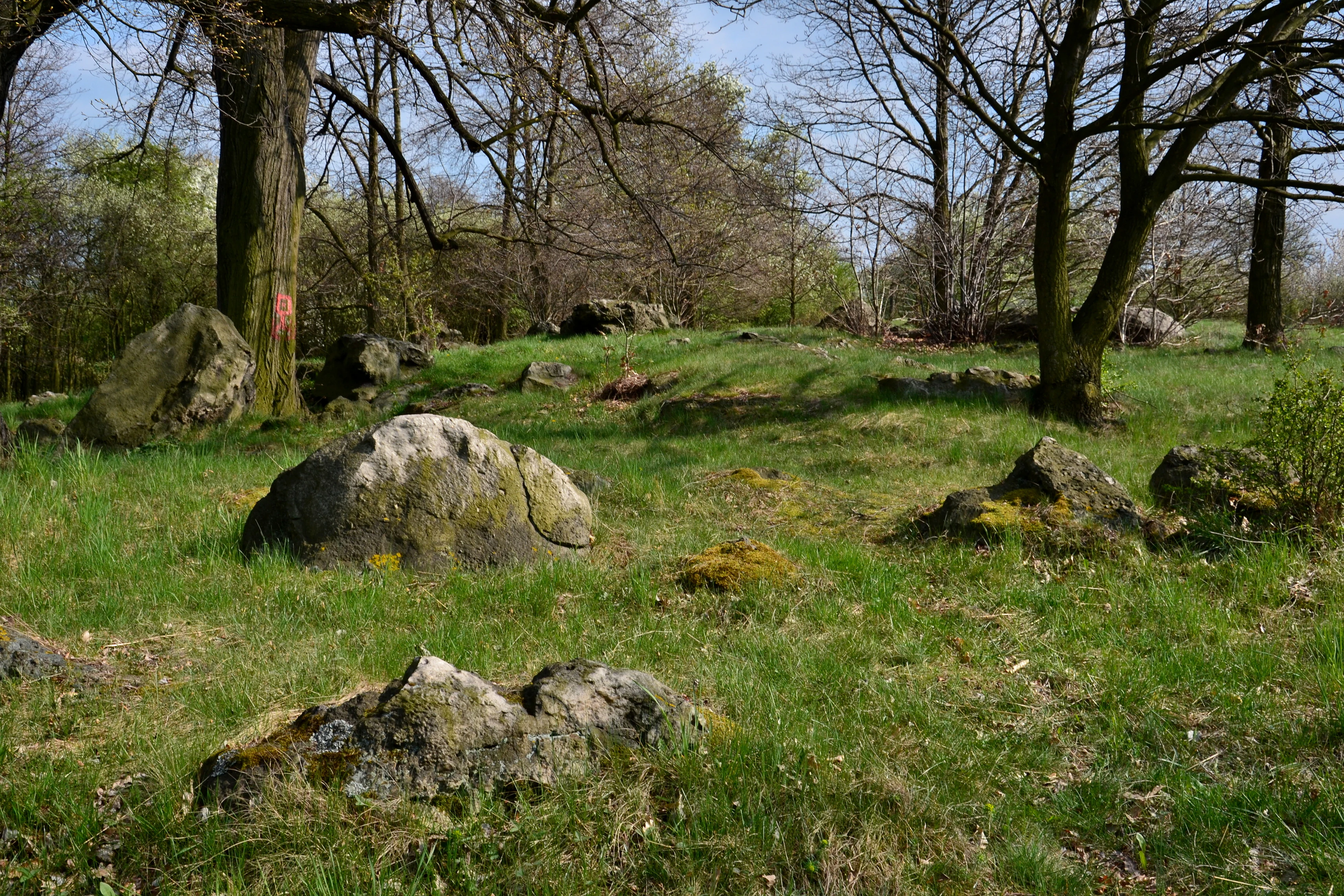
Slunaky Natural Monument
The Slunaky natural monument located in the Chomutov District, Czech Republic

Sluňáky history and protected-area timeline

The quartzite boulders at Sluňáky were once more widespread in the countryside around the village of Rokle, where they were quarried for the production of dinas, a heat-resistant material used historically in the construction of blast furnaces and other high-temperature industrial structures. The progressive removal of these boulders for industrial use gradually reduced their presence in the surrounding landscape, and the surviving group at Sluňáky is considered one of the last localities where quartzite still occurs freely on or near the surface in the Czech Republic.

Formal protection began on 24 August 1966, when the District National Committee in Chomutov designated the area as a chráněný přírodní výtvor, a protected natural creation in the terminology used at that time. The same committee re-declared the site in the same category on 27 April 1990, ensuring continued legal protection after the changes in Czech nature conservation law. The territory is now recorded as přírodní památka, the current designation corresponding to the international IUCN Category III, and is registered under the number 399 in the central list of nature conservation areas of the Czech Republic.

Sluňáky landscape and geographic character

The protected territory of Sluňáky lies in the northeastern part of the Doupovské hory, a volcanic mountain range in northwestern Bohemia, close to the boundary where the range transitions into the Mostecká pánev basin. Within this transitional zone, the landscape takes the form of a mosaic of structural ridges, small table-like hills, and volcanic cones and domes, a pattern captured by the local geomorphological unit known as the Rohozecká vrchovina.

The site itself is small and is located directly on the southeastern edge of the village of Rokle. The surrounding countryside has a varied relief shaped by volcanic activity and later erosion, and the mineralogical diversity of the area reflects this geological complexity, with gneisses at the base, volcaniclastics above them, and the quartzite boulders as a distinctive surface feature. The drainage of the area is handled by the Úhošťanský potok, a small local stream.

Sluňáky ecosystems, habitats, and plant life

From a nature conservation perspective, the protected territory is significant for its geology rather than for its biological communities. The site is a geological natural monument, and the focus of conservation is the group of quartzite boulders and the geological context in which they occur.

The wider landscape is characterized by a moderately warm climate, classified within the Czech system as Quitt climate region MT11, with average January temperatures around minus two to minus three degrees Celsius, average July temperatures around seventeen to eighteen degrees Celsius, and annual precipitation totals of roughly 550 to 650 millimeters. The soils of the immediate area are described as regozem, a type typical of disturbed or shallow substrates. Neither the flora nor the fauna of the small protected territory has been the subject of detailed investigation, and the locality is not regarded as notable for its biodiversity.

Sluňáky conservation status and protection priorities

The conservation value of Sluňáky lies primarily in the protection of a rare surface occurrence of quartzite boulders in the Czech landscape. Because similar boulders were historically removed for industrial uses, particularly the manufacture of dinas for blast furnaces, the surviving cluster represents an exceptionally well-preserved geological relict and an important reference point for understanding the Tertiary and earlier geological history of the region.

The site's inclusion in the Czech system of small-scale protected areas, both in 1966 and again in 1990, and its ongoing registration under number 399 in the national register, give the territory formal protection against further extraction or destructive land use. Its recognition as a přírodní památka within the internationally used IUCN Category III framework places it among small, scientifically valuable natural monuments whose chief importance is geological rather than ecological.

Sluňáky cultural meaning and human context

The cultural context of Sluňáky is closely tied to the industrial heritage of the Czech lands and to the region's historical relationship with raw materials drawn directly from the landscape. The quartzite boulders were once a useful local resource, valued for their resistance to heat and therefore mined or collected for the manufacture of dinas, a refractory material essential to the operation of blast furnaces.

In the wider regional setting, the area around Rokle lies in a landscape shaped by centuries of resource extraction, agriculture, and settlement, and the surviving boulders at Sluňáky are now read less as an industrial resource than as a remnant of those activities. The site's location directly at the village edge also links it to everyday local life, with the marked cycle route along the western boundary passing the territory as part of the established recreational infrastructure of the Chomutov District.

Top sights and standout views in Sluňáky

The main highlight of Sluňáky is the cluster of weathered quartzite boulders, which give the protected territory both its name and its scientific justification. These boulders represent one of the last freely exposed surface occurrences of such material in the Czech Republic and are interpreted as remnants of Tertiary quartz sandstones later silicified by solutions rising from older crystalline bedrock.

Other notable features include the geological setting at the edge of the Doupovské hory, where volcanic and crystalline rocks combine to produce a distinctive local geomorphology, and the site's historical link with quartzite mining for refractory production, which explains both its origin as a protected area and the rarity of similar surface occurrences elsewhere in the country.

Best time to visit Sluňáky

Because the site's value is essentially geological, it can be visited at most times of the year without major seasonal limitations. The climate is moderately warm, with cold winters and mild summers, and precipitation is distributed throughout the year. Spring and early autumn tend to offer comfortable temperatures and good visibility for observing the surface texture of the boulders, while winter visits are possible but may be complicated by snow cover or icy conditions on the surrounding paths.

Monthly climate preview

Long-term representative point measurements tracking monthly averages across the coordinate

Sluňáky Climate Normals: Measured Annual Temperature and Precipitation Rhythm

Historical data records the annual temperature progression and monthly precipitation rates sampled at a representative coordinate within Sluňáky. Detailed month-by-month climate metrics reveal the complete range of long-term meteorological normals established for the area.
Annual mean7 °C
-3 °C18 °C
Jan-3°
Feb-2°
Mar
Apr
May12°
Jun16°
Jul18°
Aug18°
Sep13°
Oct
Nov
Dec-2°
Warmest month
July

17.8 °C

Coolest month
January

-2.7 °C

Wettest month
July

2.7 mm/day

Driest month
April

1.4 mm/day

Park location guide

Geography guide, regional context, and park location map for Sluňáky

Sluňáky park geography, regions, and map view in Czechia

Understand where Sluňáky sits in Czechia through a broader geographic reading of the surrounding landscape, nearby location context, and its mapped position within the national park landscape.

How Sluňáky fits into Czechia

Czech Republic is a landlocked Central European country with a population of approximately 10.9 million people. The nation was established as an independent state on January 1, 1993, following the dissolution of Czechoslovakia. Its capital and largest city is Prague, with other major urban centers including Brno, Ostrava, Plzeň, and Liberec.

Wider geography shaping Sluňáky in Czechia

The Czech Republic is a landlocked country in Central Europe. It is bordered by Germany to the west, Austria to the south, Poland to the northeast, and Slovakia to the southeast. The landscape is predominantly hilly, with the territory covering 78,871 square kilometers.

Map view of Sluňáky

Use this park location map to pinpoint Sluňáky in Czechia, understand its exact geographic position, and read its mapped placement within the surrounding landscape more clearly.

Pigeon | © OpenStreetMap contributors

Location context for Sluňáky

Ústecký kraj

Explore detailed imagery of quartzite boulders and regional terrain characteristics

Sluňáky Photos and Landscape Scenery: Visualizing Protected Geology

Visual documentation provides clear insight into the weathered quartzite boulders and unique geological formations defining Sluňáky. Examining these field photographs reveals the distinct protected landscape character found within the volcanic foothills.

Slunaky Natural Monument

Slunaky Natural Monument

Park atlas

Discover related regional landscapes and connected geological monuments.

Explore Parks Near Sluňáky and Surrounding Protected Natural Areas

Browse nearby national parks and protected areas sharing the volcanic foothills and complex terrain of northwestern Bohemia. Comparing these regional sites provides broader context on local geological formations and protected natural heritage.
Nature reserveÚstecký kraj
About 2.8 km away#1 closest

South

Vinařský rybník Nature Reserve: Geographic Map and Protected Wetland Landscape

Lowland basin geography and habitat boundaries in Ústecký kraj.

Vinařský rybník represents a vital nature reserve and lowland wetland in the Ústecký kraj region, showcasing a distinct landscape of shallow ponds, reedbeds, and alluvial sediments. This site forms a key component of the regional avian habitat network, offering a concentrated look at the geological and hydrological features of the Žatecká pánev basin through detailed landscape mapping.

Area
0.151 km²
Established
1990
IUCN
IV
Relief
Upland
Protected landscapeChomutov District
About 11 km away#2 closest

South

Doupovská pahorkatina Nature Park: Mapped Geography and Protected Landscape Features

Upland volcanic terrain and steppe grasslands in Czech Republic.

Doupovská pahorkatina Nature Park protects a significant stretch of forest-steppe mosaics and rolling volcanic terrain in the southwestern part of the Chomutov District. This area stands out for its high density of dry grassland communities and wetland pockets along the Liboc river, providing a critical study of transitional geomorphology between the Doupov Mountains and the Žatecká pánev basin.

Area
47.7 km²
Established
1996
Nature reserveÚstecký kraj
About 13 km away#3 closest

Northeast

Pražská pole Nature Reserve: An Atlas of Wetland Recovery in Ústecký kraj

Protected wetland landscapes in the Czech Most Basin

Pražská pole is a remarkable nature reserve in the Ústecký kraj region, serving as a testament to natural recovery following deep brown coal mining. The site features a network of ten flooded subsidence depressions that host diverse aquatic communities, including specialized amphibians and dragonflies. This protected area offers significant value for understanding how industrial legacies transform into functional, high biodiversity wetland ecosystems within the Czech landscape.

Area
1.14 km²
Established
2024
IUCN
IV
Water
Major water bodies
Natural monumentÚstecký kraj
About 15 km away#4 closest

Northwest

Na loučkách II Natural Monument: Mapped Geography and Protected Upland Landscapes

Conservation areas in the Ore Mountains of the Ústecký kraj

Na loučkách II encompasses a substantial upland territory in the Czech Republic, characterized by a mix of peatland basins, heathland, and montane meadow mosaics. This natural monument serves as an essential ecological link within the Ore Mountains, protecting diverse highland terrain and supporting sensitive habitats in the Ústecký kraj administrative region.

Area
6.623 km²
Established
2013
IUCN
IV
Relief
Highland
Natural monumentÚstecký kraj
About 17 km away#5 closest

Northeast

Slanisko u Škrle Natural Monument and Rare Inland Saline Landscape in the Czech Republic

Geographic analysis of halophytic habitats and protected lowland terrain

The Slanisko u Škrle natural monument serves as a key reference for inland saline ecology in the Most Basin. This site preserves mineralised grasslands and rare plant communities on a south-facing slope above the Chomutovka river, providing an essential look at the intersection of geology and sensitive habitat preservation.

Area
0.034 km²
Established
2002
IUCN
IV
Relief
Lowland
Natural monumentÚstí nad Labem Region
About 17 km away#6 closest

South

Vrbina u Nové Vsi Natural Monument: Protected Habitat Mapping and Geographic Overview

Wetland and meadow conservation in the Ústí nad Labem Region

Vrbina u Nové Vsi provides a deep look into the habitat mosaic of the Doupov Mountains foothills. This protected area stands out for its concentrated distribution of ten distinct biotopes, ranging from wet alder woodlands to orchid-rich meadows, providing a comprehensive example of lowland conservation within a larger volcanic terrain context.

Area
0.113 km²
Established
2016
IUCN
IV
Relief
Upland
Natural monumentKarlovarský kraj
About 18 km away#7 closest

West

Malý Stolec Natural Monument: Volcanic Landscape and Regional Protected Area Atlas

Exposing neovolcanic rock and ancient feeder conduits in Karlovarský kraj

Malý Stolec provides a focused view into the volcanic processes of the Doupovské hory. This natural monument displays rare geologic features including columnar jointing, coarse agglomeratic tuffs, and an intruded lava body. Its location on the southern slopes above the Ohře river offers a distinct landscape character that demonstrates how localized protected areas contribute to broader European conservation frameworks.

Area
0.06 km²
Established
2016
IUCN
IV
Relief
Mountain
Nature reserveÚstecký kraj
About 18 km away#8 closest

North

Prameniště Chomutovky: Nature Reserve Boundaries and Regional Landscape Context

Protected peatland ecosystems in the Czech Republic

Prameniště Chomutovky serves as a pivotal protected area in the Ore Mountains, characterized by its deep peat deposits and open bog-pine mosaics. This documentation of the reserve includes its role as a black grouse habitat, its connection to the Novodomské rašeliniště network, and the distinct geomorphology that shapes its montane environment.

Area
18.82 km²
Established
2012
IUCN
IV
Relief
Mountain

Common questions about visiting, size, designation, and location context for Sluňáky

Sluňáky FAQs for park facts, access, geography, and protected area context

Find quick answers about Sluňáky, including protected-area facts, park geography, trail and visitor context, and how the park fits into its surrounding country and regional landscape.
MoriAtlas Explorer

Continue Your Protected Areas Search Across the Global Atlas

Deepen your exploration by continuing the structured search for national parks and protected areas worldwide. Utilize the comprehensive filtering capabilities to compare different conservation landscapes and refine your understanding of global park geography. Discover more about the distribution and characteristics of protected natural areas.

Global natural geography