
Mori Atlas logo
Protected landscapeSommerschafweide hinter dem Hockenden Stein, Auchtweide

Examining the cultural heritage, nutrient-poor grasslands, and rocky Kanzel geotope mapping

Sommerschafweide hinter dem Hockenden Stein, Auchtweide: A Protected Swabian Alb Landscape

(Landschaftsschutzgebiet Sommerschafweide hinter dem Hockenden Stein, Auchtweide)

Sommerschafweide hinter dem Hockenden Stein, Auchtweide represents a significant protected landscape situated on the Swabian Alb in Baden-Württemberg. This area preserves a historic open sheep pasture characterized by nutrient-poor grasslands and mature pasture beeches. The site sits at the highest point of the local cadastral area, featuring distinct geological elements such as the prominent Hockender Stein rock outcrop and the rocky Kanzel ensemble within the broader Kuppenalb region.

landscape protection areaSwabian AlbKuppenalbsheep pastureMagerrasendry grassland
A stylized digital illustration of a grassy hillside dotted with scattered rocky outcrops and a single prominent tree under a soft sky.

Sommerschafweide hinter dem Hockenden Stein, Auchtweide

Protected landscape

Park overview

Structured park overview, official facts, and landscape profile for Sommerschafweide hinter dem Hockenden Stein, Auchtweide

Sommerschafweide hinter dem Hockenden Stein, Auchtweide park facts, protected area profile, and essential visitor context

Review the core facts for Sommerschafweide hinter dem Hockenden Stein, Auchtweide, including designation, size, terrain, visitor scale, habitats, and operating context in one park-focused overview.

About Sommerschafweide hinter dem Hockenden Stein, Auchtweide

Sommerschafweide hinter dem Hockenden Stein, Auchtweide sits quietly on the plateau of the Middle Kuppenalb, a portion of the Swabian Alb known for its elevated limestone landscape, juniper-rich heath transitions, and centuries-old pastoral traditions. Despite its small footprint of roughly 6.5 hectares, the area encapsulates many of the qualities that define the classic Swabian Alb landscape: open vistas, sparse soils, scattered broadleaved trees, and rock outcrops that interrupt the otherwise smooth sweep of the plateau.

The locality lies about 350 meters east of Donnstetten, a village in the municipality of Römerstein, and represents the highest elevation of the Donnstetten cadastral area. The name of the protected site refers to the local field name "Auchtweide" and to the nearby geological landmark "Hockender Stein" (literally "the crouching stone"). This combination of pastoral designation and rock reference reflects how tightly the cultural and geological heritage of the plateau are intertwined here.

At the core of the protected landscape is a long-established summer sheep pasture. Grazing has shaped the vegetation into species-rich, nutrient-poor grassland, typical of the Magerrasen habitats that conservationists value across the Swabian Alb. Through this grazed landscape grow mature pasture beeches, broad, often low-crowned trees that have been shaped by centuries of browsing and cutting. These Weidebuchen are among the most iconic features of traditional Swabian pastures, and their presence gives the site much of its scenic and ecological character.

Along the western edge of the area stands a row of fifteen linden trees, forming a structured linear element within the otherwise open pasture. South of the pasture rises the Hockender Stein, a characteristically shaped rock formation that lends the protected area part of its name and serves as a visual anchor on the plateau. On the broader Kanzel hilltop, additional rock formations extend the geological interest of the site.

Quick facts and research context for Sommerschafweide hinter dem Hockenden Stein, Auchtweide

Sommerschafweide hinter dem Hockenden Stein, Auchtweide is a landscape protection area in the Reutlingen district of Baden-Württemberg, Germany. Established on 31 May 1955, it covers about 6.5 hectares on the highest elevation of the Donnstetten cadastral area within the municipality of Römerstein. Administratively overseen by the Reutlingen district office, it forms part of the Mittlere Kuppenalb natural region and is linked to the FFH site Kuppenalb bei Laichingen und Lonetal and the care zone of the Swäbische Alb Biosphere Reserve. Its protected designation is IUCN Category V (Protected Landscape/Seascape), with the national identifier 4.15.148 and WDPA ID 324653.

Protection and recognition

Documented terrestrial protection scope and recognized conservation records

Sommerschafweide hinter dem Hockenden Stein, Auchtweide Protection Status

Sommerschafweide hinter dem Hockenden Stein, Auchtweide maintains a recorded terrestrial protection scope within official conservation databases. Structured records assemble verified management parameters and designation details for this protected area.

Protection details

Protection scope
Terrestrial
Transboundary protection
No
WDPA ID
324653
Park context

Deeper park guide and search-rich context for Sommerschafweide hinter dem Hockenden Stein, Auchtweide

Sommerschafweide hinter dem Hockenden Stein, Auchtweide history, landscape, wildlife, and travel context

Explore Sommerschafweide hinter dem Hockenden Stein, Auchtweide through its history, landscape character, ecosystems, wildlife, conservation priorities, cultural context, and seasonal travel timing in a structured park guide built for atlas discovery and search intent.

Why Sommerschafweide hinter dem Hockenden Stein, Auchtweide stands out

The area is best known for its traditional open sheep pasture landscape, where grazed nutrient-poor grassland is interwoven with ancient, characterful pasture beeches that define the cultural landscape of the Swabian Alb. It is also distinguished by the prominent rock formation known as the Hockender Stein and the broader rocky ensemble on the Kanzel, which together give the location a striking and recognizable profile on the highest point of the Donnstetten cadastral area.
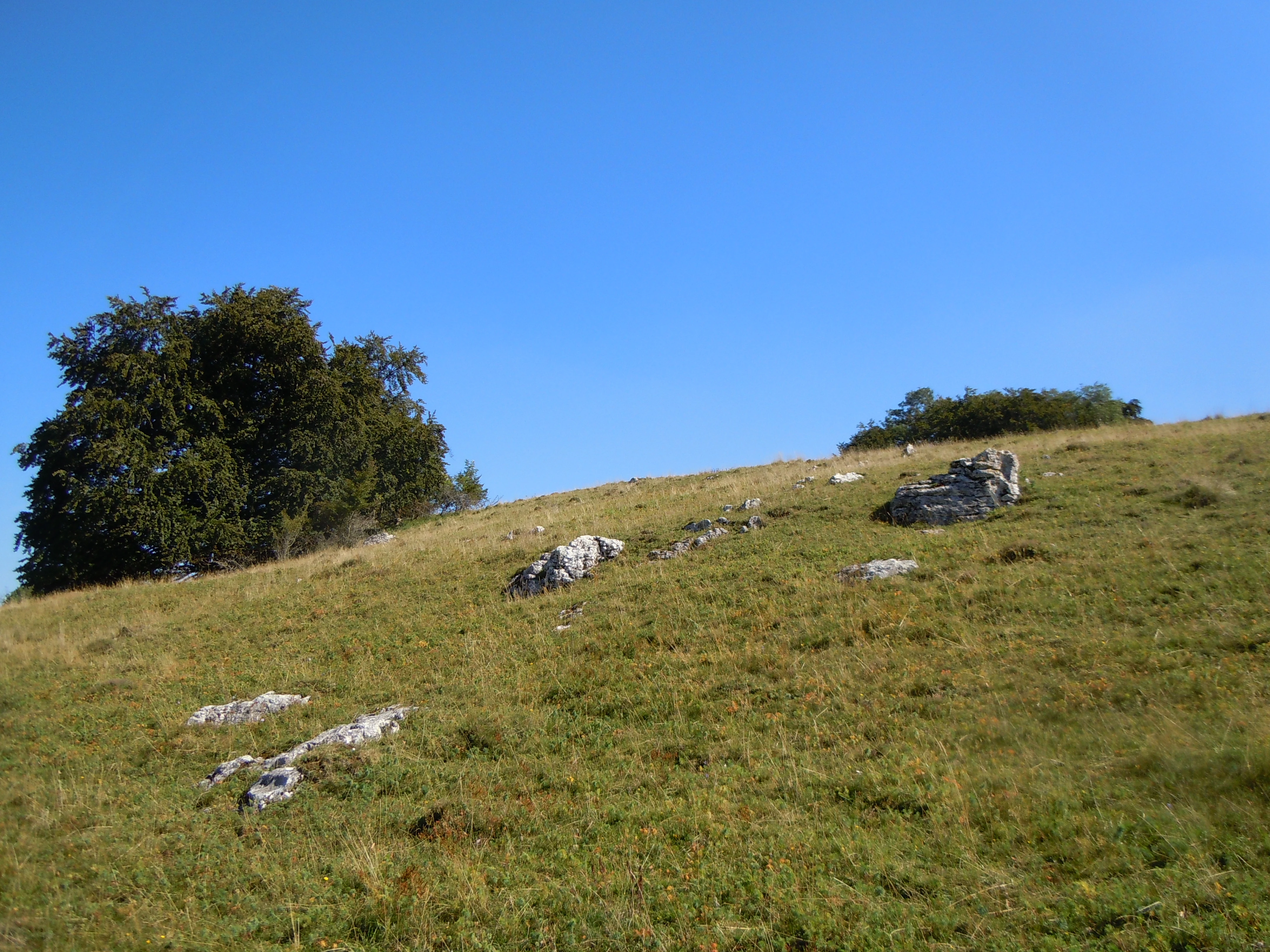
A gentle grassy hill slope under a clear blue sky, featuring a large leafy tree on the left and several prominent grey limestone rock outcrops scattered across the meadow.
A view of the open sheep pasture landscape, featuring scattered limestone rocks and trees within the Sommerschafweide hinter dem Hockenden Stein protection area.

Sommerschafweide hinter dem Hockenden Stein, Auchtweide history and protected-area timeline

The Sommerschafweide hinter dem Hockenden Stein, Auchtweide has been used as a summer sheep pasture for generations, forming part of the traditional pastoral economy that shaped the Swabian Alb before modern agriculture.

Its formal protection is comparatively old by the standards of German landscape conservation. On 31 May 1955, the then Landratsamt Münsingen issued a legal ordinance designating the roughly 6.5-hectare pasture as a Landschaftsschutzgebiet. At the time, this made the Kanzel pasture among the many landscape protection areas established across the district to preserve characteristic cultural landscapes.

Since the 1970s regional reorganization, administrative responsibility has rested with the Landratsamt Reutlingen, and the site has been integrated into broader conservation frameworks on the Swabian Alb. It became part of the FFH area Kuppenalb bei Laichingen und Lonetal and the care zone of the Schwäbische Alb UNESCO Biosphere Reserve, extending its originally local protection into a wider European and international conservation context. Individual elements such as the linden row, notable pasture beeches, the Kanzel rock ensemble, and the Hockender Stein have separately been designated as natural monuments, with the rock features also recognized as protected geotopes.

Sommerschafweide hinter dem Hockenden Stein, Auchtweide landscape and geographic character

The landscape of Sommerschafweide hinter dem Hockenden Stein, Auchtweide is defined by the open, elevated character of the Swabian Alb plateau. The site occupies the highest point of the Donnstetten cadastral area and belongs to the natural region of the Mittlere Kuppenalb, a landscape shaped by limestone bedrock, shallow soils, and centuries of grazing pressure.

Rather than forest or dense scrub, the surface is dominated by grazed grassland broken by individual broadleaved trees. The interplay of open pasture and scattered mature trees creates the classic, almost park-like appearance typical of historic Swabian sheep walks. A linear row of fifteen linden trees runs along the western edge of the area, providing a deliberate structural element within the otherwise irregular distribution of trees.

The defining geological feature is the Hockender Stein, a prominently shaped rock outcrop in the southern portion of the protected area. Beyond this single rock, the broader Kanzel hilltop supports additional rock formations that together form a small but visually striking rocky ensemble. These outcrops emphasize the karst-like character of the surrounding plateau and break the horizon line of the otherwise gently rolling Alb surface.

Sommerschafweide hinter dem Hockenden Stein, Auchtweide ecosystems, habitats, and plant life

Ecologically, the protected area belongs to the Magerrasen habitat family, a category of nutrient-poor, species-rich grassland that has historically depended on grazing for its character and survival. These dry grassland communities are important refuges for specialized plants and invertebrates across the Swabian Alb and are one of the principal reasons such pastures are placed under landscape protection.

The mature pasture beeches that punctuate the grassland are not merely scenic features. They provide structural diversity, microhabitats for insects, birds, and bats, and contribute to the overall biodiversity of an otherwise open landscape. The linden row along the western boundary adds another layer of habitat structure, offering nesting sites, floral resources, and old-growth characteristics that are increasingly rare in modern agricultural landscapes.

The site's integration into the FFH area Kuppenalb bei Laichingen und Lonetal and into the care zone of the Schwäbische Alb Biosphere Reserve reflects the recognition that its small-size ecosystems are functionally linked to the wider conservation network of the Middle Kuppenalb. The combination of grassland, scattered broadleaves, and rocky outcrops provides a mosaic of microhabitats that is characteristic of the region.

Sommerschafweide hinter dem Hockenden Stein, Auchtweide wildlife and species highlights

The sheep pasture environment of Sommerschafweide hinter dem Hockenden Stein, Auchtweide is shaped by grazing rather than wild herbivores, although the structural complexity of the site still supports a meaningful community of wild fauna. The open Magerrasen provide habitat for invertebrate groups typical of dry grasslands on the Swabian Alb, including butterflies, wild bees, and other pollinators associated with species-rich, low-nutrient vegetation.

The mature pasture beeches and the linden row create vertical structure that benefits birds and bats, with old trees often supporting cavity-nesting species and a rich community of saproxylic insects. The combination of open ground for foraging and mature trees for nesting and roosting is a hallmark of traditional Swabian Alb pastures and contributes to their wildlife value well beyond what their small size might suggest.

Being embedded within the broader Kuppenalb area, the site also functions as a small node in a wider network of habitats used by wildlife moving across the plateau, including species associated with juniper heaths, woodland edges, and rocky outcrops in the region.

Sommerschafweide hinter dem Hockenden Stein, Auchtweide conservation status and protection priorities

The site's principal conservation value lies in the preservation of a traditional Swabian Alb sheep pasture, a cultural landscape whose ecological qualities depend on continued grazing and careful management. Without ongoing use as a Schafweide, the open Magerrasen character of the area would gradually be lost to scrub encroachment, making the protected designation an active safeguard of both ecological and cultural heritage.

The pasture beeches, the linden row, the Kanzel rock ensemble, and the Hockender Stone are also recognized individually as natural monuments, with the rock features additionally protected as geotopes. This layering of designations reflects how the site combines biological, landscape, and geological importance in a single small area.

At the broader scale, the site forms part of the FFH area Kuppenalb bei Laichingen und Lonetal, an EU Habitats Directive site, and lies within the care zone of the Schwäbische Alb UNESCO Biosphere Reserve. These frameworks connect the local protection of the Auchtweide with international conservation objectives, ensuring that even a 6.5-hectare pasture contributes to the long-term preservation of the Middle Kuppenalb's distinctive ecosystems.

Sommerschafweide hinter dem Hockenden Stein, Auchtweide cultural meaning and human context

The historical use of the area as a Sommerschafweide, a summer sheep pasture, places it firmly within the centuries-old pastoral culture of the Swabian Alb. Sheep husbandry shaped the vegetation, the tree cover, and the scenic character of the plateau, and traditionally managed pastures such as this one are considered an integral part of the region's cultural identity.

Names embedded in the site carry local historical meaning. The field name "Auchtweide" and the landmark "Hockender Stein" point to a layered rural vocabulary that links agriculture, geology, and local topography. Rock formations on the Kanzel and the location's role as the highest point of the Donnstetten cadastral area also suggest that the site may have held local landmarks and orientation points for the surrounding communities.

As part of the Schwäbische Alb Biosphere Reserve, the pasture is now framed not only as a heritage landscape but also as a model of sustainable land use, illustrating how traditional pastoral practices can coexist with modern nature conservation goals.

Top sights and standout views in Sommerschafweide hinter dem Hockenden Stein, Auchtweide

Despite its small size, Sommerschafweide hinter dem Hockenden Stein, Auchtweide combines several distinct elements into one of the more recognizable protected pastures on the Middle Kuppenalb: a grazed Magerrasen landscape, mature Weidebuchen, a fifteen-tree linden row, the Hockender Stein outcrop, and the broader Kanzel rock ensemble, all sitting at the highest elevation of the Donnstetten cadastral area. The site is one of the older landscape protection areas on the Swabian Alb, having been designated in 1955, and is now anchored within both the FFH area Kuppenalb bei Laichingen und Lonetal and the care zone of the Schwäbische Alb Biosphere Reserve.

Best time to visit Sommerschafweide hinter dem Hockenden Stein, Auchtweide

As an open, grazed pasture on the Swabian Alb plateau, the site is most inviting when vegetation is in active growth, typically from late spring through early autumn, when the interplay of flowering Magerrasen, leafy pasture beeches, and accessible rock outcrops is at its most expressive. Late spring and early summer tend to coincide with peak grassland biodiversity on the Alb, while early autumn often brings clearer views across the plateau and more comfortable walking conditions. Visitors should keep in mind that the area is a working pasture, with sheep present during the grazing season, and is best appreciated as a quiet cultural and natural landscape rather than as a formal visitor attraction.

Monthly climate preview

Long-term monthly temperature and precipitation rhythm from 1991 to 2020

Sommerschafweide hinter dem Hockenden Stein, Auchtweide Climate Profile

Representative coordinates record annual temperature extremes spanning sub-zero winter minimums and warm summer peaks alongside steady daily precipitation rates. Examining the complete twelve-month record reveals detailed climatic patterns across the protected landscape.
Annual mean8 °C
-1 °C18 °C
Jan-1°
Feb
Mar
Apr
May13°
Jun16°
Jul18°
Aug18°
Sep14°
Oct
Nov
Dec
Warmest month
July

18.2 °C

Coolest month
January

-1.1 °C

Wettest month
July

3.2 mm/day

Driest month
February

1.7 mm/day

Park location guide

Geography guide, regional context, and park location map for Sommerschafweide hinter dem Hockenden Stein, Auchtweide

Sommerschafweide hinter dem Hockenden Stein, Auchtweide park geography, regions, and map view in Germany

Understand where Sommerschafweide hinter dem Hockenden Stein, Auchtweide sits in Germany through a broader geographic reading of the surrounding landscape, nearby location context, and its mapped position within the national park landscape.

How Sommerschafweide hinter dem Hockenden Stein, Auchtweide fits into Germany

Germany is a federal republic in Western and Central Europe with a population of over 83 million across sixteen constituent states. It is Europe's largest economy by nominal GDP and a major global exporter and importer. The capital is Berlin, and the country borders Denmark, Poland, Czech Republic, Austria, Switzerland, France, Luxembourg, Belgium, and the Netherlands.

Wider geography shaping Sommerschafweide hinter dem Hockenden Stein, Auchtweide in Germany

Germany is located in Western and Central Europe, spanning 357,022 km². It borders Denmark to the north, Poland and the Czech Republic to the east, Austria and Switzerland to the south, and France, Luxembourg, Belgium, and the Netherlands to the west. The country has coastlines on the Baltic Sea and North Sea to the north, with the Alps located in the southern region.

Map view of Sommerschafweide hinter dem Hockenden Stein, Auchtweide

Use this park location map to pinpoint Sommerschafweide hinter dem Hockenden Stein, Auchtweide in Germany, understand its exact geographic position, and read its mapped placement within the surrounding landscape more clearly.

Pigeon | © OpenStreetMap contributors

Location context for Sommerschafweide hinter dem Hockenden Stein, Auchtweide

Baden-Württemberg

Visualizing the traditional sheep pastures, mature pasture beeches, and geological formations of the Swabian Alb

Sommerschafweide hinter dem Hockenden Stein, Auchtweide Photos and Protected Landscape Scenery

Photographic documentation reveals the distinct terrain, ancient pasture trees, and exposed limestone outcrops defining Sommerschafweide hinter dem Hockenden Stein, Auchtweide. Visual exploration provides a clearer understanding of the protected grassland habitats and elevated plateau character preserved across the Swabian Alb.

A gentle grassy hill slope under a clear blue sky, featuring a large leafy tree on the left and several prominent grey limestone rock outcrops scattered across the meadow.

Park atlas

Compare nearby regional landscapes and connected protected terrain across the Swabian Alb plateau

Parks Near Sommerschafweide hinter dem Hockenden Stein, Auchtweide and Related Protected Areas

Browse protected areas and regional nature reserves located near Sommerschafweide hinter dem Hockenden Stein, Auchtweide. Comparing adjacent conservation landscapes provides broader geographic context for the surrounding plateau terrain.
Watercolor illustration of rolling green hills, trees, and wildflowers, with a soft, bright, and light aesthetic.
Protected landscapeBaden-Württemberg
About 5.8 km away#1 closest

Northeast

Oberes Filstal-Stadt Wiesensteig: Protected Landscape and Regional Geography Mapping

An atlas overview of the Mittlere Kuppenalb landscape mosaic

Covering roughly 171 hectares around Wiesensteig, this protected area serves as a vital component of the central Swabian Alb geography. The site features an undulating karst terrain characterized by a dense forest mosaic, hedgerows, and historic pastoral features. Through its alignment with local Natura 2000 sites, it forms a cohesive ecological bridge between the upper Fils valley and the surrounding high plateau.

Area
1.71 km²
Established
1985
IUCN
V
Relief
Highland
A soft watercolor painting depicting rolling green hills and meadows against a white background.
Protected landscapeBaden-Württemberg
About 6.9 km away#2 closest

North

Neidlinger Tal Protected Landscape: Regional Geography and Mapped Boundaries

A study of the Swabian Alb and Alb foreland transition terrain

The Neidlinger Tal protected landscape represents a vital intersection of natural regions in Baden-Württemberg. Its boundaries encompass a mosaic of forest and farmland, providing a comprehensive look at how historical land use patterns coexist with modern conservation efforts within the Swabian Alb, including various bird and habitat protection designations.

Area
10.959 km²
Established
1975
IUCN
V
Relief
Upland
Protected landscapeBaden-Württemberg
About 8.1 km away#3 closest

Northeast

Oberes Filstal-Gemeinde Mühlhausen im Täle: Protected Landscape Geography and Map Data

Swabian Alb regional landscape and habitat mosaic

Analyze the protected landscape of Oberes Filstal-Gemeinde Mühlhausen im Täle through its unique physical terrain and ecological structure. This area in the Göppingen district features a complex interplay of river valleys and plateau uplands, creating a habitat corridor that links the Fils valley with the wider Swabian Alb, supporting diverse flora and traditional land-use patterns.

Area
5.13 km²
Established
1983
IUCN
V
A soft watercolor illustration showing a rolling landscape with gentle hills, grassy fields, and tree lines in shades of green, yellow, and faint pink.
Protected landscapeBaden-Württemberg
About 10 km away#4 closest

North

Oberes Filstal-Gemeinde Gruibingen: Protected Landscape and Regional Geography

Swabian Alb terrain within the Göppingen district

Oberes Filstal-Gemeinde Gruibingen forms a crucial ecological envelope around specialized nature reserves on the Swabian Alb. The landscape is defined by its characteristic kuppen hill-and-basin topography, featuring ridge slopes, stream-cut valleys, and traditional agricultural land that supports high floristic diversity within the Baden-Württemberg region.

Area
1.71 km²
Established
1984
IUCN
V
Protected landscapeBaden-Württemberg
About 11 km away#5 closest

North

Weilheim an der Teck auf Gemarkungen Weilheim und Hepsisau Protected Landscape Atlas

Volcanic hill geography in the Baden-Württemberg region

This protected area safeguards a richly structured landscape where rolling foothills meet the steep escarpments of the Swabian Alb. Centered on the volcanic peaks of Limburg and Egelsberg, the region maintains a vital balance between forest corridors and open agricultural plains within the district of Esslingen.

Area
13.615 km²
Established
1979
IUCN
V
Watercolor painting of a rolling landscape featuring light green hills, patches of trees, and white rock outcrops against a soft, light-colored background.
Protected landscapeBaden-Württemberg
About 11 km away#6 closest

Southwest

Öde im Hartberg Protected Landscape and Geological Features of the Middle Swabian Alb

Juniper heathland and limestone outcrops in Baden-Württemberg

Situated at the mouth of the Fischburgtal, Öde im Hartberg is a significant protected area on the Middle Swabian Alb. The site preserves a unique mosaic of open heath and successional woodland, anchored by the Hartbergfels and Seeburger Nägelesfels limestone monuments. It offers a clear look at the geological and conservation landscape of this southwestern German region.

Area
0.101 km²
Established
1955
IUCN
V
Protected landscapeBaden-Württemberg
About 12 km away#7 closest

Southwest

Wolfsschlucht Protected Landscape: Swabian Alb Gorge Geography and Regional Mapping

A key geotope within the central Swabian Alb mountain terrain.

Wolfsschlucht preserves a distinctive limestone gorge and ravine forest system within a compact 1.4 hectare area. Its geography highlights the intersection of karst landforms, steep valley relief, and layered conservation status, serving as a representative model of the central Swabian Alb's geological and ecological character in Baden-Württemberg.

Area
0.014 km²
Established
1955
IUCN
V
A horizontal watercolor painting depicting a soft-focus landscape with green fields, patches of trees, and rolling hills in the background under a pale sky.
Protected landscapeBaden-Wuerttemberg
About 13 km away#8 closest

East

Nellingen Protected Landscape: Mapping the Cultural and Karstic Terrain of Central Swabia

Protected landscape geography and regional land use

Nellingen Protected Landscape encompasses over 1,500 hectares of the Swabian Alb, forming an essential link in the regional conservation network. This site provides insight into the karstic landforms of the Kuppenalb, including sinkholes and dry valleys, while preserving a living history of agricultural practices such as orchard management and sheep grazing. This analysis provides a structured overview of the area topography and its significance in the regional landscape context.

Area
15.212 km²
Established
1999
IUCN
V
Relief
Upland

Common questions about visiting, size, designation, and location context for Sommerschafweide hinter dem Hockenden Stein, Auchtweide

Sommerschafweide hinter dem Hockenden Stein, Auchtweide FAQs for park facts, access, geography, and protected area context

Find quick answers about Sommerschafweide hinter dem Hockenden Stein, Auchtweide, including protected-area facts, park geography, trail and visitor context, and how the park fits into its surrounding country and regional landscape.
MoriAtlas Explorer

Continue Your Protected Areas Search Across the Global Atlas

Deepen your exploration by continuing the structured search for national parks and protected areas worldwide. Utilize the comprehensive filtering capabilities to compare different conservation landscapes and refine your understanding of global park geography. Discover more about the distribution and characteristics of protected natural areas.

Global natural geography