
Mori Atlas logo
Protected landscapeSpeicherbecken Orrot

A detailed look at the reservoir, wetland mosaic, and forested valley terrain in the Ostalbkreis region.

Speicherbecken Orrot: Mapping the Protected Landscape and Valley Geography in Baden-Wuerttemberg

(Landschaftsschutzgebiet „Speicherbecken Orrot")

Speicherbecken Orrot represents a vital protected landscape in the Schwäbisch-Fränkische Waldberge of Baden-Wuerttemberg. This area captures the interplay between the Orrotsee reservoir, surrounding wooded slopes, and diverse wetland habitats including tall-sedge marshes and wet meadows. Analyze the boundaries and natural topography that define this unique reservoir-centered valley system through our integrated geographic dataset.

landscape protection areareservoirvalley landscapewetlandtall-sedge marshwet meadow
A flat-style digital illustration of a calm lake surrounded by dense evergreen and deciduous forests under a soft, hazy sky.

Speicherbecken Orrot

Protected landscape

Park overview

Structured park overview, official facts, and landscape profile for Speicherbecken Orrot

Speicherbecken Orrot park facts, protected area profile, and essential visitor context

Review the core facts for Speicherbecken Orrot, including designation, size, terrain, visitor scale, habitats, and operating context in one park-focused overview.

About Speicherbecken Orrot

Speicherbecken Orrot is a landscape protection area located in the eastern part of Baden-Württemberg, in the Ostalbkreis between the communities of Jagstzell and Rosenberg. The protected landscape spans the Orrot valley and is anchored by the Orrotsee, a reservoir whose calm water surface defines the visual and ecological character of the area.

The region lies within the natural area known as the Schwäbisch-Fränkische Waldberge, a transitional forested upland that bridges the landscapes of the Swabian Alb to the south and the Franconian Keuper uplands to the north. This setting gives Speicherbecken Orrot its slight relief, with gentle slopes, narrow valley sections, and a mix of woodland and open water that typify many of the smaller protected areas in this part of Baden-Württemberg.

Designated in 1968, the reserve reflects the era's growing emphasis on safeguarding regional reservoir and valley landscapes for their combined ecological, hydrological, and recreational values. Beyond the main lake, the protection area includes the Rennecker Sägmühleweiher, several fish ponds, a larger pond south of the reservoir, a wet meadow above the lake, and a sizable tall-sedge marsh near the upper pond, creating a layered network of aquatic and wetland habitats.

The area links into wider conservation planning: the larger pond south of the Orrotsee is part of the FFH area Virngrund und Ellwanger Berge, anchoring Speicherbecken Orrot within a broader ecosystem network. As one of many small landscape protection areas in the Ostalbkreis, it offers a compact example of how reservoir infrastructure and protected natural values can coexist in a single valley.

Quick facts and research context for Speicherbecken Orrot

Speicherbecken Orrot is a 56.7-hectare landscape protection area (Landschaftsschutzgebiet) located in the Ostalbkreis of Baden-Württemberg, spanning the municipal areas of Jagstzell and Rosenberg. It was designated on 5 December 1968 and is administered by the Landratsamt Ostalbkreis. The area is classified under IUCN Category V (Protected Landscape/Seascape) and bears the official identifier 1.36.019, with WDPA record 324715. Geographically it belongs to the natural region of the Schwäbisch-Fränkische Waldberge.

Protection and recognition

Explore official protection records and recognized conservation designations for Speicherbecken Orrot.

Speicherbecken Orrot Protection Status and Documented Conservation Data

Examine the documented protection status, management scope, and international recognition records established for Speicherbecken Orrot. Review verified conservation data and official protected area attributes maintained within global environmental databases.

Protection details

WDPA ID
324715
Park context

Deeper park guide and search-rich context for Speicherbecken Orrot

Speicherbecken Orrot history, landscape, wildlife, and travel context

Explore Speicherbecken Orrot through its history, landscape character, ecosystems, wildlife, conservation priorities, cultural context, and seasonal travel timing in a structured park guide built for atlas discovery and search intent.

Why Speicherbecken Orrot stands out

The reserve is best known for the Orrotsee, a reservoir whose still water surface forms the visual heart of the protected area. Surrounding the lake are wooded valley slopes, scattered fish ponds, a wet meadow above the lake, and an extensive tall-sedge marsh near the Rennecker Sägmühleweiher, together creating a varied mosaic of water, wetland, and forest habitats. It is also recognized as part of the regional mosaic of protected landscapes in the eastern Schwäbisch-Fränkische Waldberge, contributing to habitat continuity between the Ostalbkreis reservoir landscape and the FFH area Virngrund und Ellwanger Berge.
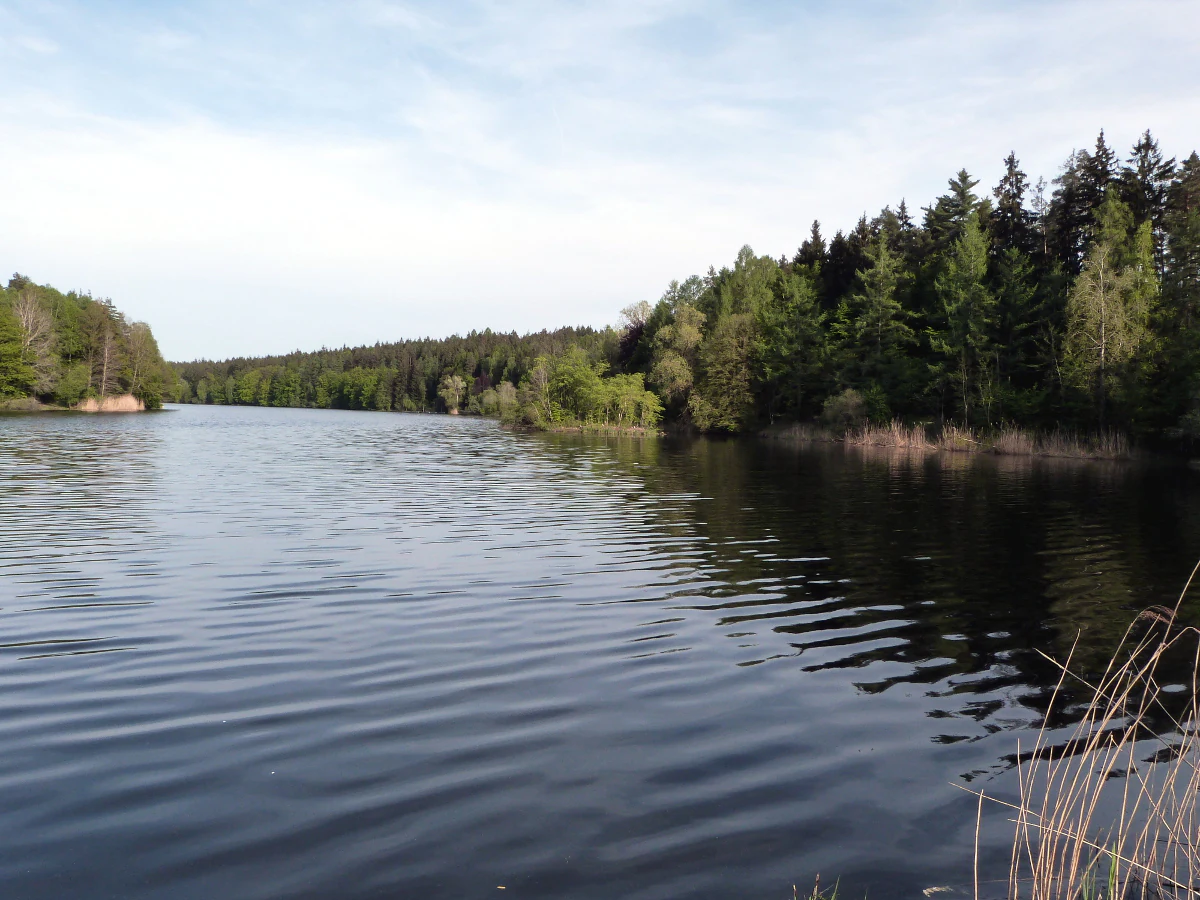
A wide angle view of a dark, rippled reservoir surrounded by lush green forests under a light sky.
A view across the calm waters of the Orrotsee reservoir, surrounded by dense woodlands.

Speicherbecken Orrot history and protected-area timeline

Speicherbecken Orrot was formally designated as a landscape protection area on 5 December 1968 through a regulation issued by the Landratsamt Aalen, the district office responsible at the time. Its designation placed the Orrotsee reservoir and the surrounding Orrot valley under the protection category Landschaftsschutzgebiet, a status used in Baden-Württemberg to preserve regionally important landscapes with combined ecological, scenic, and functional values.

Following regional administrative reforms, responsibility for the area passed to the successor Landratsamt Ostalbkreis, which continues to oversee the reserve today. Over time, the protection area has also become part of the broader conservation planning in the region, with portions of it integrated into the FFH area Virngrund und Ellwanger Berge, reinforcing its role within the wider ecological framework of the eastern Swabian-Franconian Forest.

Speicherbecken Orrot landscape and geographic character

The landscape of Speicherbecken Orrot is shaped above all by water and forest. The Orrotsee dominates the valley floor with its broad, calm surface, bordered by steep, wooded valley slopes that rise on both sides. These slopes create the enclosed, valley-like character that gives the protected area its distinct scenery.

Beyond the main reservoir, the area contains several additional water bodies that diversify the landscape. The Rennecker Sägmühleweiher sits at the upper end of the protected section, while several smaller fish ponds and a larger pond south of the lake extend the wetland footprint of the area. Between the lake and the slopes, gentle transitions from open water to wet meadow and forest create a varied relief typical of the Schwäbisch-Fränkische Waldberge region.

The valley form, the contrast between reflective water and dark woodland, and the small-scale mosaic of ponds and meadows together define the visual identity of Speicherbecken Orrot, distinguishing it from the broader plateau landscapes that surround it.

Speicherbecken Orrot ecosystems, habitats, and plant life

The reserve protects a compact but ecologically diverse cross-section of habitats in the Orrot valley. The Orrotsee and its associated ponds form the aquatic core of the area, while the forested valley slopes contribute continuous woodland cover along the edges.

Above the lake, a wet meadow (Feuchtwiese) marks the transition from open water to drier terrain, supporting moisture-loving plant communities. Near the Rennecker Sägmühleweiher, an extensive tall-sedge marsh (Großseggenried) provides additional wetland habitat, offering cover and resources for wetland-dependent species.

The combination of standing water, marshland, wet meadow, and forest creates a layered habitat structure. This ecological mosaic, although limited in total area, represents a characteristic slice of the valley ecosystems that the Schwäbisch-Fränkische Waldberge natural region is known for.

Speicherbecken Orrot wildlife and species highlights

The protected area's mosaic of open water, marsh, wet meadow, and forested slopes creates habitat for typical valley and wetland wildlife of the eastern Swabian-Franconian Forest. The Orrotsee and the surrounding ponds attract waterfowl and other water-associated species, while the Großseggenried near the Rennecker Sägmühleweiher provides habitat for marsh-dependent fauna.

The continuous woodland on the valley slopes offers cover and movement corridors for forest species typical of the region. The combination of these habitat types within a single small-scale valley supports a varied, though not extensively documented, community of birds, amphibians, and insects associated with aquatic, wetland, and forest edge environments.

Speicherbecken Orrot conservation status and protection priorities

Speicherbecken Orrot is classified as a landscape protection area under the German nature conservation framework, corresponding to IUCN Category V (Protected Landscape/Seascape). Its conservation significance lies in maintaining a coherent valley landscape that combines a working reservoir with ecologically valuable water, wetland, and forest habitats.

The protected area's connection to the FFH area Virngrund und Ellwanger Berge through the larger pond south of the Orrotsee gives it added conservation weight, integrating it into the broader Natura 2000 planning context for the region. The reserve helps maintain habitat continuity and water-linked ecological corridors within the Schwäbisch-Fränkische Waldberge, supporting regional biodiversity strategies even at a relatively small scale.

Speicherbecken Orrot cultural meaning and human context

The Orrot valley carries traces of traditional landscape use in the region. The presence of the Rennecker Sägmühleweiher reflects the historical importance of small mill ponds in the forest valleys of the Schwäbisch-Fränkische Waldberge, where waterpower was once used for local milling and sawing operations. The continued existence of such ponds within a protected area illustrates the layered relationship between historical land use and modern conservation in this part of Baden-Württemberg.

Top sights and standout views in Speicherbecken Orrot

Speicherbecken Orrot stands out for the compact interplay of reservoir, marshland, and forested valley within a single protected area. The Orrotsee, the Rennecker Sägmühleweiher, and the associated Großseggenried together form one of the more characteristic small wetland landscapes of the Ostalbkreis.

Best time to visit Speicherbecken Orrot

The reserve is shaped by water and woodland, and its character shifts with the seasons in ways typical of the Schwäbisch-Fränkische Waldberge. Spring and early summer bring fresh foliage on the valley slopes and active conditions in the wetland habitats around the Orrotsee and the Rennecker Sägmühleweiher. Autumn highlights the forested setting with seasonal color in the surrounding woodland, while winter often gives the area a quiet, still atmosphere around the reservoir surface.


Monthly climate preview

Long-term monthly temperature averages and precipitation records for Baden-Wuerttemberg

Speicherbecken Orrot Climate Normals and Annual Temperature Patterns

Representative coordinates record annual temperature extremes and daily precipitation amounts spanning twelve distinct monthly periods. Examining full monthly climate normals reveals detailed seasonal fluctuations across the local protected landscape.
Annual mean9 °C
-1 °C18 °C
Jan-1°
Feb
Mar
Apr
May13°
Jun16°
Jul18°
Aug18°
Sep14°
Oct
Nov
Dec
Warmest month
July

18.4 °C

Coolest month
January

-1 °C

Wettest month
July

3 mm/day

Driest month
April

1.6 mm/day

Park location guide

Geography guide, regional context, and park location map for Speicherbecken Orrot

Speicherbecken Orrot park geography, regions, and map view in Germany

Understand where Speicherbecken Orrot sits in Germany through a broader geographic reading of the surrounding landscape, nearby location context, and its mapped position within the national park landscape.

How Speicherbecken Orrot fits into Germany

Germany is a federal republic in Western and Central Europe with a population of over 83 million across sixteen constituent states. It is Europe's largest economy by nominal GDP and a major global exporter and importer. The capital is Berlin, and the country borders Denmark, Poland, Czech Republic, Austria, Switzerland, France, Luxembourg, Belgium, and the Netherlands.

Wider geography shaping Speicherbecken Orrot in Germany

Germany is located in Western and Central Europe, spanning 357,022 km². It borders Denmark to the north, Poland and the Czech Republic to the east, Austria and Switzerland to the south, and France, Luxembourg, Belgium, and the Netherlands to the west. The country has coastlines on the Baltic Sea and North Sea to the north, with the Alps located in the southern region.

Map view of Speicherbecken Orrot

Use this park location map to pinpoint Speicherbecken Orrot in Germany, understand its exact geographic position, and read its mapped placement within the surrounding landscape more clearly.

Pigeon | © OpenStreetMap contributors

Location context for Speicherbecken Orrot

Baden-WuerttembergOstalbkreis

Explore detailed photographic records of reservoir waters, wooded valley slopes, and wetland habitats.

Visualizing Speicherbecken Orrot: Landscape Photography and Protected Area Scenery

Visual documentation captures the interplay between the calm Orrotsee reservoir and surrounding forested valley slopes within the protected landscape. Examining these field photographs reveals the distinctive wetland habitats and topography defining the regional character of Speicherbecken Orrot.

A wide angle view of a dark, rippled reservoir surrounded by lush green forests under a light sky.

Park atlas

Compare nearby protected areas and regional valley reserves across Baden-Württemberg.

Parks Near Speicherbecken Orrot and Surrounding Protected Landscapes

Browse other protected areas and regional valley reserves situated close to Speicherbecken Orrot. Extending the geographic review allows comparison of similar wetland habitats and forested uplands across the surrounding regional terrain.
A horizontal watercolor illustration depicting a soft, pastel landscape with rolling hills in the background, a small pond, and several green and light pink flowering trees.
Nature reserveBaden-Württemberg
About 3.2 km away#1 closest

North

Crailsheimer Hart und Reusenberg: Protected Nature Reserve and Karst Landscape Geography

Jagst valley protected habitat in Baden-Württemberg

Crailsheimer Hart und Reusenberg represents a key conservation unit in southwest Germany. This nature reserve is recognized for its distinctive gypsum keuper geology, which creates a network of dolines, semi-dry grasslands, and near-natural floodplain forests. Understanding its boundaries provides insight into habitat connectivity within the broader Baden-Württemberg protected-area network.

Area
7.14 km²
Established
2019
A soft watercolor painting of a river valley with green fields, distant hills, and a prominent tree in the foreground on the right.
Protected areaBaden-Württemberg
About 15 km away#2 closest

Northwest

Bühlertal Vellberg-Geislingen: Protected River Valley and Karst Geography

A concentrated habitat corridor in Baden-Württemberg

This protected area follows the Bühler river through a series of tight meanders and dramatic limestone formations. The landscape is characterized by a transition from wet floodplain woods and tall-herb fringes to dry calcareous grasslands and hillside forests. Covering over 800 hectares, the site serves as a vital ecological link across the Kocher-Jagst plains and the forested ridges of the Schwäbisch-Fränkische Waldberge.

Area
8.474 km²
Established
2019
Relief
Upland
Climate
Temperate
Watercolor painting of a river winding through a gentle green valley with distant hills.
Nature reserveBaden-Württemberg
About 16 km away#3 closest

North

Jagst bei Kirchberg und Brettach Nature Reserve: Protected River Landscapes of Baden-Württemberg

River valleys, calcareous grasslands, and limestone terrain in Southwestern Germany.

The Jagst bei Kirchberg und Brettach nature reserve preserves a diverse corridor of natural river meanders, floodplain meadows, and beech forests. Situated in the Baden-Württemberg region, this protected area spans nearly 900 hectares, offering a rich study in limestone geology and riparian ecology within the Kocher-Jagst plains.

Area
8.93 km²
Established
2019
Relief
Upland
Climate
Temperate
A soft watercolor illustration of rolling hills and gentle terrain in shades of pale green and muted earth tones against a white background.
Protected landscapeMittelfranken
About 18 km away#4 closest

Northeast

Naturpark Frankenhöhe Protected Landscape: Geography, Map, and Regional Conservation Context

Explore the diverse natural terrain of the Mittelfranken region in Bavaria.

Naturpark Frankenhöhe serves as a significant protected landscape in western Mittelfranken, encompassing a unique mosaic of forests, vineyards, and agricultural valleys. This geographic entity is shaped by the European Main Watershed, where rivers divide between the Rhine and Danube systems. Its terrain provides a study in transitions, from higher forested crests to open orchard meadows that define the local Bavarian countryside.

Area
1,104.06 km²
Established
1974
Relief
Mixed relief
Climate
Temperate
Faint watercolor illustration of rolling green hills and a pinkish foreground against a white background.
Protected areaBaden-Württemberg
About 25 km away#5 closest

Southwest

Albtrauf Donzdorf-Heubach: Protected Escarpments and Karst Terrain in the Swabian Alb

Natura 2000 protected area in eastern Baden-Württemberg

The Albtrauf Donzdorf-Heubach site comprises eight protected parcels along the Swabian Alb. Its geography is defined by steep limestone cliffs, dissected valleys, and extensive karst systems that support specialized biodiversity. This protected landscape highlights the complex interaction between Upper Jurassic geological formations and traditional land-use patterns across the Göppingen and Ostalbkreis districts.

Area
25.333 km²
Established
2019
Relief
Highland
Climate
Temperate
A horizontal watercolor painting showing rolling green meadows with small clusters of trees and soft hills in the background on a white background.
Protected areaBaden-Württemberg
About 26 km away#6 closest

South

Albuchwiesen: A Protected Landscape of Wetlands and Historical Grasslands on the Swabian Alb

Geographic atlas of the smallest Habitats Directive site in Baden-Württemberg

Albuchwiesen represents a critical refuge for wetland biodiversity outside the Brenz valley, characterized by its scattered parcels of calcareous dry grasslands and wet meadow systems. The area preserves essential remnants of historical land use on the Ostalb, including distinct clay-lined ponds and transitional mires that define this localized plateau terrain.

Area
51.1 km²
Established
2019
Protected landscapeBaden-Württemberg
About 28 km away#7 closest

South

Ur-Brenztal Protected Landscape: Geography and River Valley Mapping in Baden-Württemberg

Wetland meadow corridors and ancestral drainage relics

Ur-Brenztal stands as a vital protected landscape in the Landkreis Heidenheim, serving as a rare open grassland passage. The area preserves flat valley floors and low-energy stream channels that provide essential stepping stone habitats for migratory birds and meadow-nesting populations between regional high plateaus.

Area
0.69 km²
Established
2003
IUCN
V
Relief
Lowland
Protected landscapeBaden-Württemberg
About 32 km away#8 closest

South

Weidmichele, Eichelesäcker und anschließender Talgrund Protected Landscape Atlas

Geographic analysis of Swabian Alb dry valley terrain

Examine the topographical profile of Weidmichele, Eichelesäcker und anschließender Talgrund. This landscape protection area showcases the classic karst dry valley form found in Baden-Württemberg, providing a vital, narrow grassland corridor between upland plateaus and the lower Brenz valley ecosystem.

Area
0.153 km²
Established
1978
IUCN
V

Common questions about visiting, size, designation, and location context for Speicherbecken Orrot

Speicherbecken Orrot FAQs for park facts, access, geography, and protected area context

Find quick answers about Speicherbecken Orrot, including protected-area facts, park geography, trail and visitor context, and how the park fits into its surrounding country and regional landscape.
MoriAtlas Explorer

Continue Your Protected Areas Search Across the Global Atlas

Deepen your exploration by continuing the structured search for national parks and protected areas worldwide. Utilize the comprehensive filtering capabilities to compare different conservation landscapes and refine your understanding of global park geography. Discover more about the distribution and characteristics of protected natural areas.

Global natural geography