

Mori Atlas logo
Protected landscapeSpruce Knob-Seneca Rocks National Recreation Area

Mapping the high-country summits, quartzite crags, and river canyons of West Virginia

Spruce Knob-Seneca Rocks National Recreation Area: A Protected Landscape in the Allegheny Mountains

Spruce Knob-Seneca Rocks National Recreation Area serves as a landmark protected landscape within the Allegheny Mountains of West Virginia. This area encompasses the dramatic high-elevation terrain of Spruce Knob, the sheer quartzite fin of Seneca Rocks, and the carved river corridors of Smoke Hole Canyon. Through these distinct geographic features, the landscape offers a study in Appalachian topography, high-country ecology, and historical land management.

national recreation areaAllegheny Mountainshigh countryred spruce forestquartzite cliffsrock climbing
A digital illustration of jagged rock formations surrounded by pine and deciduous forest under a bright sky.

Spruce Knob-Seneca Rocks National Recreation Area

Protected landscape

Park overview

Structured park overview, official facts, and landscape profile for Spruce Knob-Seneca Rocks National Recreation Area

Spruce Knob-Seneca Rocks National Recreation Area park facts, protected area profile, and essential visitor context

Review the core facts for Spruce Knob-Seneca Rocks National Recreation Area, including designation, size, terrain, visitor scale, habitats, and operating context in one park-focused overview.

About Spruce Knob-Seneca Rocks National Recreation Area

Spruce Knob-Seneca Rocks National Recreation Area sits in the heart of West Virginia's Allegheny Highlands, a region defined by long forested ridges, deep river valleys, and elevations that rise well above the surrounding lowlands. As part of the broader Monongahela National Forest, the recreation area links together some of the most distinctive natural landmarks in the state, anchoring both the highcountry scenery and the river-carved terrain of the upper South Branch Potomac watershed.

The recreation area functions as a single protected unit that preserves very different mountain environments within its boundaries. At its southwestern end rises Spruce Knob, the highest peak in West Virginia and the highest point in the entire Allegheny Mountains. Its summit supports a high-elevation forest dominated by red spruce, a vegetation type more commonly associated with the northern Appalachians or higher latitudes, and its open, alpine-like bald and observation areas offer long-distance views across the surrounding ridges. The mountain's wide, rounded profile contrasts sharply with the much more abrupt terrain found at the other end of the recreation area.

At its northeastern end stands Seneca Rocks, one of the most photographed and frequently climbed geological features in the eastern United States. The formation is a tall fin of resistant Tuscarora quartzite that has been sculpted into a series of vertical and slightly overhanging walls, making it a landmark for rock climbers and a striking visual feature from the valley below. Connected to Seneca Rocks by the winding South Branch valley is Smoke Hole Canyon, a remote and scenic stretch of the South Branch Potomac River known for its quiet character, exposed rock walls, and reputation as a wild, lightly developed corridor of the highlands.

The wider recreation area also protects large tracts of the surrounding Monongahela National Forest, including mixed northern hardwood forests, spruce stands, riparian zones, ridgelines, and backcountry hollows typical of the central Appalachians. This combination of summit forest, cliff country, and river canyon gives the area a layered identity in which a single visit can move from alpine-style mountaintop scenery to sheer quartzite walls to the carved banks of an Appalachian river.

Quick facts and research context for Spruce Knob-Seneca Rocks National Recreation Area

Spruce Knob-Seneca Rocks National Recreation Area lies in eastern West Virginia within the Monongahela National Forest. It encompasses roughly 100,000 acres of forested mountain terrain in the Allegheny Highlands and protects three major landmarks: Spruce Knob, the highest point in West Virginia; Seneca Rocks, a tall quartzite crag famous for its climbing routes; and Smoke Hole Canyon, a scenic stretch of the South Branch Potomac River.

The recreation area was created by Congress on September 28, 1965, as the first national recreation area ever established within a U.S. National Forest. Its administration remains under the U.S. Forest Service through the Monongahela National Forest. Although it is not a national park in the strict sense, it functions as one of West Virginia's most important outdoor recreation landscapes.

Protection and recognition

Documented terrestrial protection scope and designation records

Spruce Knob-Seneca Rocks National Recreation Area Protection Status

Spruce Knob-Seneca Rocks National Recreation Area maintains a documented terrestrial protection scope across its managed landscape. Official records outline the assigned protection status and administrative designation parameters without international recognition sources.

Protection details

Protection scope
Terrestrial
Transboundary protection
No
Park context

Deeper park guide and search-rich context for Spruce Knob-Seneca Rocks National Recreation Area

Spruce Knob-Seneca Rocks National Recreation Area history, landscape, wildlife, and travel context

Explore Spruce Knob-Seneca Rocks National Recreation Area through its history, landscape character, ecosystems, wildlife, conservation priorities, cultural context, and seasonal travel timing in a structured park guide built for atlas discovery and search intent.

Why Spruce Knob-Seneca Rocks National Recreation Area stands out

Spruce Knob-Seneca Rocks is best known as the home of Spruce Knob, the highest point in West Virginia and the apex of the Allegheny Mountains. The spruce-fir forests and exposed, rolling summit of Spruce Knob give the area its most distinctive high-country character. Equally iconic is Seneca Rocks, a near-vertical quartzite formation rising above the North Fork of the South Branch of the Potomac River. The rock is one of the most recognizable climbing venues in the eastern United States and has become a visual symbol of West Virginia's mountain outdoors. Together with the quieter but equally dramatic Smoke Hole Canyon, these three landmarks define the recreation area's reputation as a landscape of summits, cliffs, and river canyons.
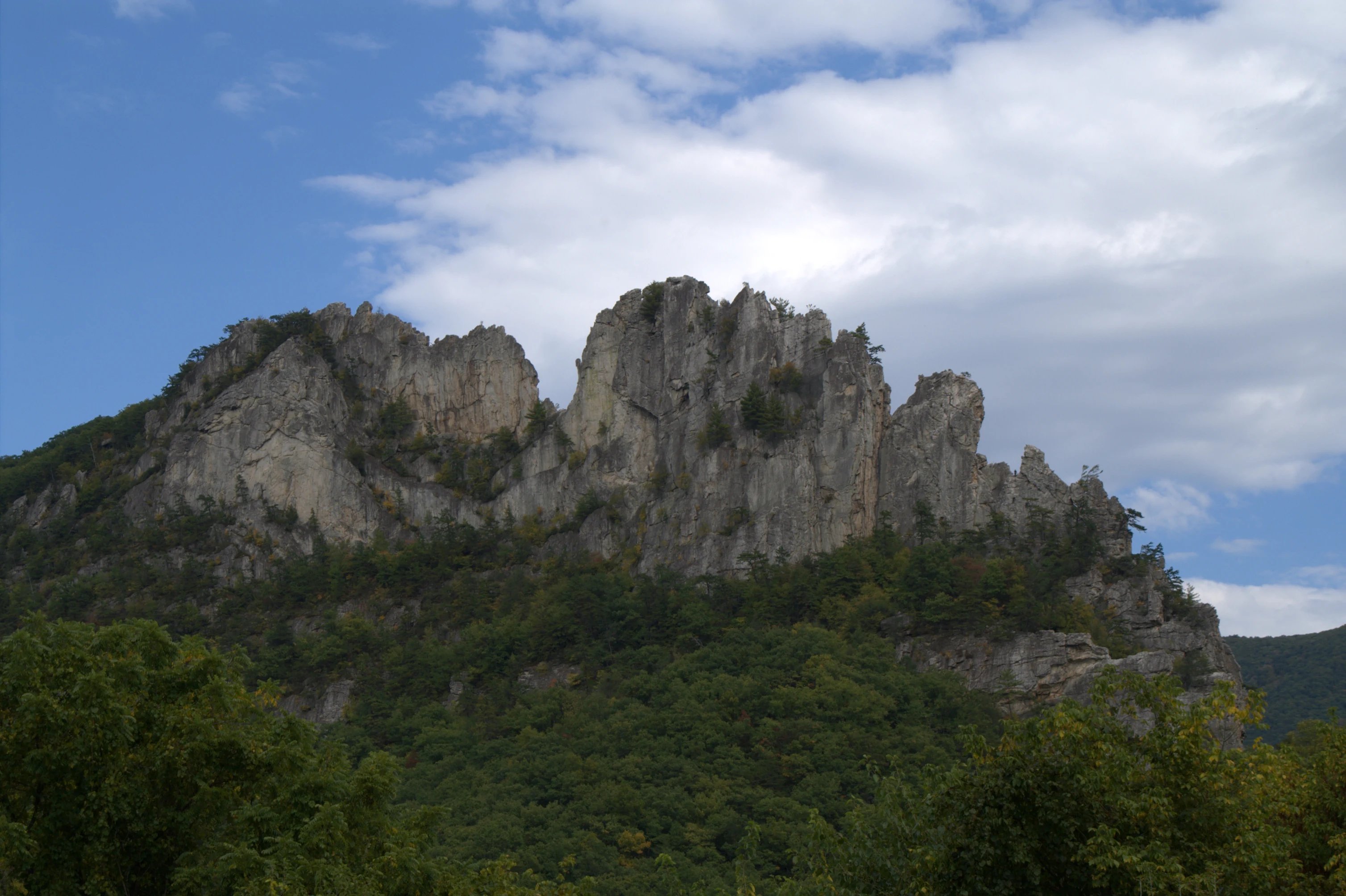
A jagged, light-colored rock formation stands against a blue sky with white clouds, above a dense green forest.
A view of the prominent Seneca Rocks formation rising above the surrounding forest.

Spruce Knob-Seneca Rocks National Recreation Area history and protected-area timeline

Spruce Knob-Seneca Rocks National Recreation Area was established on September 28, 1965, through an act of the United States Congress. Its creation marked an early and significant moment in the development of the national recreation area concept on lands managed by the U.S. Forest Service. By being designated within the Monongahela National Forest rather than as a stand-alone national park, it became the first national recreation area ever created within a U.S. National Forest, a precedent that shaped how later national recreation areas were conceived and managed.

The decision to formalize this landscape as a national recreation area reflected growing recognition of the outstanding recreational, scenic, and ecological values concentrated in the highlands of eastern West Virginia. Spruce Knob, Seneca Rocks, and Smoke Hole Canyon had each long attracted attention from hikers, climbers, anglers, and travelers, and uniting them under a single recreation area designation allowed for coordinated protection and management.

Administration of the recreation area has remained under the U.S. Forest Service through the Monongahela National Forest since its founding. Over time, the area has continued to serve as a major hub for outdoor recreation in West Virginia, and its geology, scenery, and high-elevation forests have contributed to broader recognition of the Allegheny Highlands as one of the most distinctive landscapes in the central Appalachians.

Spruce Knob-Seneca Rocks National Recreation Area landscape and geographic character

The landscape of Spruce Knob-Seneca Rocks National Recreation Area is shaped by the high ridges, sweeping valleys, and incised river corridors of the Allegheny Mountains. Elevations rise to the summit of Spruce Knob, West Virginia's highest point, while the river valleys of the South Branch Potomac cut deeply down through the surrounding terrain, producing the steep, narrow gorges that frame much of the recreation area.

Spruce Knob itself presents a broad, rounded, alpine-like summit that stands above the more typical Appalachian ridge scenery. Its exposed mosaic of spruce forest, grassy openings, and rocky crest offers sweeping views across the Allegheny Highlands and gives the area its most distinctive high-country terrain. In contrast, the approach to Seneca Rocks moves through the surrounding ridges before opening onto the dramatic quartzite crag itself: a long, narrow fin of exposed rock that rises abruptly from the valley floor and dominates the local skyline.

The South Branch Potomac River and its tributaries have carved much of the rest of the recreation area, producing Smoke Hole Canyon and a network of connected valleys. These river corridors are defined by steep forested slopes, exposed rock walls, quiet pools, and remote, lightly developed shoreline. The combination of high rolling summits, abrupt quartzite cliffs, and deeply carved river valleys gives the recreation area a landscape character that shifts dramatically across its extent despite its relatively compact size within West Virginia.

Spruce Knob-Seneca Rocks National Recreation Area ecosystems, habitats, and plant life

Ecologically, the recreation area reflects the transitional character of the central Appalachian highlands, where northern spruce-fir forests meet more southerly mixed hardwood communities. The result is a layered habitat mosaic that supports unusually diverse plant communities for a single protected area of its size.

Spruce Knob and the surrounding high ridges support stands of red spruce, a conifer more typical of cooler northern climates. These spruce forests give the high country a distinctive evergreen character and create habitat conditions that differ markedly from the warm-season hardwood forests that dominate most of West Virginia. Lower elevations across the recreation area support classic Appalachian hardwood communities of oak, maple, birch, hickory, and beech, along with patches of hemlock in cooler drainages.

Riparian habitats along the South Branch Potomac and its tributaries add another layer of ecological diversity. The river corridors and their forested slopes provide habitat for aquatic species, migratory birds, and mammals that use both the riverbanks and the surrounding forested uplands. Across these zones, the recreation area protects a connected mosaic of boreal-like summit forest, mixed Appalachian hardwoods, rocky cliffs, and river valley woodland, making it an unusually rich ecological landscape within West Virginia.

Spruce Knob-Seneca Rocks National Recreation Area wildlife and species highlights

The varied habitats of the recreation area support wildlife characteristic of the central Appalachian highlands. Mixed hardwood forests, spruce stands, cliffs, and river corridors each contribute to a broad mammal and bird presence typical of well-forested mountain regions of West Virginia.

White-tailed deer and black bear are among the most frequently encountered larger mammals across the broader Monongahela landscape. Smaller mammals, including squirrels, foxes, raccoons, and various mustelids, are also present in the area's forests, while the rock outcrops around Seneca Rocks and the rocky slopes of Smoke Hole Canyon provide habitat for reptile and small mammal species that favor rugged terrain.

The recreation area is also a rewarding birding environment. Raptors and forest songbirds are found in the mixed hardwood and spruce stands, while the river corridors of the South Branch Potomac attract both resident and migratory species. The combination of high-elevation conifer forest, cliff habitat, hardwood slopes, and riparian woodland gives the area a particularly diverse bird community within West Virginia, though its wildlife significance is generally expressed through ecological richness rather than any single headline species.

Spruce Knob-Seneca Rocks National Recreation Area conservation status and protection priorities

The conservation significance of Spruce Knob-Seneca Rocks National Recreation Area lies in the protection it provides to a comprehensive cross-section of West Virginia's high-country ecosystems. By uniting Spruce Knob's high-elevation spruce forests, the cliff-and-valley landscape of Seneca Rocks, and the forested river corridor of Smoke Hole Canyon under a single national recreation area designation, the area safeguards habitats that are unusual within the state and central to the identity of the Allegheny Highlands.

The high-elevation red spruce communities around Spruce Knob are of particular conservation interest because they represent a vegetation type more typically associated with northern Appalachian or boreal environments and are limited in extent across West Virginia. Protecting these stands in their mountain setting is a core part of the area's long-term ecological value. At the same time, the mixed hardwood forests of the surrounding slopes, the cliff and talus systems around Seneca Rocks, and the riparian habitat along the South Branch Potomac combine to form a connected conservation landscape rather than a collection of isolated landmarks.

Because the recreation area is administered through the Monongahela National Forest, its management is integrated with the broader forest plan, balancing recreation use, habitat protection, watershed health, and scenic preservation. Its status as the first national recreation area established within a U.S. National Forest also gives it historical importance in the evolution of conservation-oriented recreation policy across the national forest system.

Spruce Knob-Seneca Rocks National Recreation Area cultural meaning and human context

The human story of the recreation area is closely tied to the cultural identity of the Allegheny Highlands of eastern West Virginia. Seneca Rocks has long been a landmark in regional lore, art, and outdoor tradition, and the broader Monongahela National Forest grew out of a long history of small-scale mountain settlement, logging, and resource use that shaped both the local economy and the landscape.

The region's Appalachian heritage is reflected in the surrounding communities, in the trail networks and early recreation infrastructure, and in the longstanding relationship between West Virginians and their mountain landscapes. While the recreation area does not center on a single dramatic cultural site, its scenery, climbing history, and high-country forests are woven into the broader outdoor and mountain culture of the state.

Top sights and standout views in Spruce Knob-Seneca Rocks National Recreation Area

Spruce Knob-Seneca Rocks stands out for combining three very different West Virginia landmarks into one protected mountain landscape: a high spruce-clad summit, a steep quartzite climbing crag, and a long, quiet river canyon. This layered identity is unusual within a single national recreation area and gives the place a strong visual and ecological range.

Its standing as the first national recreation area established within a U.S. National Forest adds additional weight, situating the site as a foundational example in the history of national forest recreation management. For visitors interested in mountain scenery, Appalachian ecology, rock climbing, and remote river landscapes, the recreation area offers a concentrated showcase of the best-known features of West Virginia's high country.

Best time to visit Spruce Knob-Seneca Rocks National Recreation Area

Seasonal character strongly shapes a visit to Spruce Knob-Seneca Rocks National Recreation Area. Late spring through early fall is generally when the area is most accessible and most rewarding for hiking, scenic driving, and rock climbing, with warmer temperatures at the lower elevations and lingering cool conditions on the exposed summit of Spruce Knob. Autumn is especially notable for fall foliage across the hardwood forests of the Allegheny Highlands, when the ridgelines and river valleys take on vivid color.

Winter brings cold temperatures and snow to the higher elevations, transforming Spruce Knob into a notably more severe, northern-like landscape and adding a quieter, more austere atmosphere to the broader area. Summer offers the warmest conditions for enjoying river corridors and lower-elevation trails, but the open summit of Spruce Knob can remain cooler and windier than surrounding lowlands. Across all seasons, the contrast between the exposed high country and the sheltered river valleys gives the recreation area a strong sense of seasonal mood that rewards visitors in different ways throughout the year.

Monthly climate preview

Long-term representative temperature and precipitation averages across twelve months

Spruce Knob-Seneca Rocks National Recreation Area Climate and Weather by Month

Spruce Knob-Seneca Rocks National Recreation Area records measured monthly temperature and precipitation data based on historical averages from a representative coordinate. Reviewing the complete twelve-month profile provides deeper analytical context for long-term climate patterns across the protected terrain.
Annual mean9 °C
-3 °C21 °C
Jan-3°
Feb-2°
Mar
Apr
May15°
Jun19°
Jul21°
Aug21°
Sep17°
Oct11°
Nov
Dec-1°
Warmest month
July

21.2 °C

Coolest month
January

-2.9 °C

Wettest month
May

3.8 mm/day

Driest month
October

2.4 mm/day

Park location guide

Geography guide, regional context, and park location map for Spruce Knob-Seneca Rocks National Recreation Area

Spruce Knob-Seneca Rocks National Recreation Area park geography, regions, and map view in United States of America

Understand where Spruce Knob-Seneca Rocks National Recreation Area sits in United States of America through a broader geographic reading of the surrounding landscape, nearby location context, and its mapped position within the national park landscape.

How Spruce Knob-Seneca Rocks National Recreation Area fits into United States of America

The United States of America is a federal presidential republic and one of the world's largest countries by area and population. It consists of 50 states across a vast territory spanning multiple time zones, with its capital in Washington, D.C. and largest city in New York City. The nation has a diverse economy, influential political system, and significant cultural and military presence globally.

Wider geography shaping Spruce Knob-Seneca Rocks National Recreation Area in United States of America

The United States occupies a vast territory in North America, bordered by Canada to the north and Mexico to the south. The 48 contiguous states stretch from the Atlantic to the Pacific Ocean, while Alaska occupies the northwestern region and Hawaii is an archipelago in the Pacific. The country encompasses diverse terrain including the Rocky Mountains, Appalachian Mountains, Great Plains, and extensive river systems.

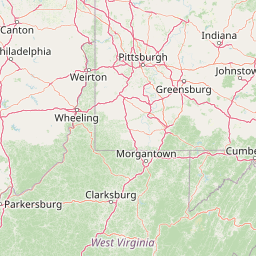
Map view of Spruce Knob-Seneca Rocks National Recreation Area

Use this park location map to pinpoint Spruce Knob-Seneca Rocks National Recreation Area in United States of America, understand its exact geographic position, and read its mapped placement within the surrounding landscape more clearly.

Pigeon | © OpenStreetMap contributors

Location context for Spruce Knob-Seneca Rocks National Recreation Area

West Virginia

Visual exploration of high-elevation ridges, quartzite crags, and river canyon habitats

Spruce Knob-Seneca Rocks National Recreation Area Photos and Mountain Scenery

Visual documentation captures the varied terrain of Spruce Knob-Seneca Rocks National Recreation Area, featuring high-altitude spruce forests, steep rock fins, and carved river corridors. Examining these protected landscapes reveals the distinct geological features and native habitats that define the Allegheny Mountains.

A jagged, light-colored rock formation stands against a blue sky with white clouds, above a dense green forest.

Park atlas

Compare adjacent Allegheny Mountain protected areas and regional landscapes

Other Parks Near Spruce Knob-Seneca Rocks National Recreation Area

Browsing other parks near Spruce Knob-Seneca Rocks National Recreation Area reveals connected high-country terrain and regional protected landscapes across the Allegheny Mountains. Continuing into nearby conservation areas expands geographic comparison across surrounding mountain ridges and river valleys.
Watercolor painting showing layers of soft green hills and mountain ridges fading into a light hazy background.
Protected landscapeWest Virginia
Mapped location lies within the park boundary#1 closest

West

Monongahela National Forest: Protected Appalachian Landscapes and Regional Geography

Mapping West Virginia wilderness and mountain terrain

Monongahela National Forest protects nearly one million acres of the central Appalachian Mountains. This massive federally managed landscape is defined by the Allegheny Front, the highest peak in the Allegheny range at Spruce Knob, and iconic geological formations like Seneca Rocks. The region represents a vital intersection of climate, hydrology, and biodiversity in the eastern United States, housing eight distinct wilderness areas and complex high-altitude ecosystems.

Area
3,727.8 km²
Established
1920
Visitors
3M annual
Relief
Mountain
A pale, abstract watercolor painting showing a wide view of soft, layered green and pink mountains with a few stylized trees in the lower right.
Wildlife reserveWest Virginia
About 7.3 km away#2 closest

Northwest

Roaring Plains West Wilderness: Geographic Overview and Protected Plateau Mapping

High-altitude wilderness and Appalachian watershed geography

Roaring Plains West Wilderness encompasses one of the largest high-elevation plateaus in the eastern United States. This protected area within West Virginia hosts dramatic rim-rock vistas and extensive sphagnum bogs, standing as a primary ecological feature along the Eastern Continental Divide. Examine the mapped terrain and environmental boundaries of this significant Allegheny Mountain preserve.

Area
27.6 km²
Established
2009
IUCN
Ib
Relief
Highland
A minimalist watercolor painting showing rolling green hills and a flat plateau with abstract vegetation against a white background.
Wildlife reserveWest Virginia
About 14 km away#3 closest

North

Dolly Sods Wilderness: Geography and Protected Landscape Analysis for West Virginia

High-altitude plateaus and sub-arctic Appalachian terrain.

Trace the boundaries and protected landscape of Dolly Sods Wilderness, a 17,000-acre wildlife reserve in West Virginia. This atlas-focused look highlights the area's geological elevation near 4,000 feet, its unique plant communities including sphagnum bogs, and the distinct role of its recovering ecosystems within the larger Monongahela National Forest.

Area
71.94 km²
Established
1975
IUCN
Ib
Visitors
7.5K annual
Wildlife reserveWest Virginia
About 22 km away#4 closest

West

Laurel Fork North Wilderness: Mapping Appalachian Forest and Mountain Terrain

Protected wilderness landscape in the West Virginia highlands.

Laurel Fork North Wilderness sits as a key conservation unit within the Monongahela National Forest. This protected territory preserves a complex of high-elevation hardwood forests and the stream-cut valley of Laurel Fork. By examining this region, users gain insight into the geography of Allegheny mountain wilderness and the persistent character of recovery-focused Appalachian landscapes.

Area
24.5 km²
Established
1983
IUCN
Ib
Relief
Mountain
A wide, panoramic watercolor illustration showing a row of green trees, faint mountains in the background, and grass reeds in the foreground left against a white background.
Wildlife reserveWest Virginia
About 29 km away#5 closest

Southwest

Laurel Fork South Wilderness: Protected Appalachian Highlands and Forested Terrain

High elevation forest and creek drainage geography

Laurel Fork South Wilderness features a dense, unbroken stretch of Appalachian forest within West Virginia. This protected landscape is defined by its deep narrow hollows and high ridgelines, representing a vital example of mid elevation mountain terrain and recovering forest ecosystems within the Monongahela National Forest.

Area
23.41 km²
Established
1983
IUCN
Ib
Relief
Mountain
Watercolor illustration depicting a serene mountain landscape with a winding river, rolling hills, and scattered trees against a light background.
Protected landscapeVirginia
About 49 km away#6 closest

Southeast

George Washington and Jefferson National Forests: Appalachian Protected Landscape Mapping

Explore mountain ridges, river valleys, and wilderness corridors in Virginia.

Covering one of the largest public forest blocks in the eastern United States, George Washington and Jefferson National Forests offer a unique look at the central Appalachian mountain terrain. The area includes extensive wilderness tracts, the Appalachian Trail corridor, and significant geological landmarks like the Breaks gorge. Analyze the protected landscape boundaries and topographic features that define this major regional watershed and forest network.

Area
7,247.65 km²
Established
1995
Relief
Mountain
Climate
Temperate
A soft watercolor illustration depicting a stream flowing through a forested valley with mountain ridgelines in the background.
Wildlife reserveUnited States of America
About 56 km away#7 closest

South

Ramseys Draft Wilderness: Appalachian Ridge and Valley Protected Landscape and Map Atlas

Examining wilderness boundaries and mountain stream geography in Virginia

Located in western Virginia, Ramseys Draft Wilderness is a federal protected area characterized by its extreme vertical relief and rugged Appalachian topography. Spanning from the main crest of Shenandoah Mountain to the valley floor, this wilderness serves as a vital corridor for high-elevation forest ecosystems, native brook trout, and neotropical migrant birds.

Area
26.38 km²
Established
1984
Relief
Mountain
Climate
Temperate
Watercolor painting of rolling hills, trees, and a river in a scenic landscape
National parkVirginia
About 77 km away#8 closest

East

Shenandoah National Park: National Park Protected Landscape and Geography

Mapped terrain and protected area context in Virginia.

Shenandoah National Park is a designated national park in Virginia, offering a rich exploration of its protected landscape and geographic features. This page provides detailed atlas-oriented information, focusing on the park's mapped boundaries and its role within the regional geography. Discover the natural terrain and spatial identity of this important US protected area, ideal for understanding park landscapes.

Area
811.176 km²
Established
1935
IUCN
II
Visitors
1.7M annual

Common questions about visiting, size, designation, and location context for Spruce Knob-Seneca Rocks National Recreation Area

Spruce Knob-Seneca Rocks National Recreation Area FAQs for park facts, access, geography, and protected area context

Find quick answers about Spruce Knob-Seneca Rocks National Recreation Area, including protected-area facts, park geography, trail and visitor context, and how the park fits into its surrounding country and regional landscape.
MoriAtlas Explorer

Continue Your Protected Areas Search Across the Global Atlas

Deepen your exploration by continuing the structured search for national parks and protected areas worldwide. Utilize the comprehensive filtering capabilities to compare different conservation landscapes and refine your understanding of global park geography. Discover more about the distribution and characteristics of protected natural areas.

Global natural geography