Mori Atlas logo
Nature reserveSteinbühl-Schäfergraben

Examining a pioneering model for grazing-based habitat management in Rhineland-Palatinate

Steinbühl-Schäfergraben: An Authorized Nature Reserve and Porphyry Quarry Conservation Landscape

(Naturschutzgebiet Steinbühl-Schäfergraben)

Steinbühl-Schäfergraben is a distinct nature reserve in the Donnersbergkreis district of western Germany, recognized for its transformation from an industrial porphyry quarry into a vital open habitat. This protected area utilizes year-round grazing with hardy Taurus cattle and Konik horses to maintain its unique, sun-exposed terrain. The site serves as a significant biological model, illustrating how post-industrial ground can be successfully redirected for long-term ecological conservation within the broader agricultural landscape.

nature reserveformer quarryporphyrygrazing projectconservation grazingKonik horses

Steinbühl-Schäfergraben

Nature reserve

Park overview

Structured park overview, official facts, and landscape profile for Steinbühl-Schäfergraben

Steinbühl-Schäfergraben park facts, protected area profile, and essential visitor context

Review the core facts for Steinbühl-Schäfergraben, including designation, size, terrain, visitor scale, habitats, and operating context in one park-focused overview.

About Steinbühl-Schäfergraben

Steinbühl-Schäfergraben is a small but ecologically remarkable protected landscape in the Donnersbergkreis district of Rhineland-Palatinate, in the rolling countryside of the German Pfalz region. Centered on about 67 hectares north of Kirchheimbolanden, the reserve occupies land whose industrial past and ecological present sit in striking contrast.

The bedrock of the area is porphyry, an igneous rock that was quarried here by a commercial operator before the site's modern history took a different turn. Quarrying left behind raw ground, broken terrain, and a mosaic of exposed rock faces and bare substrates that, by ecological accident rather than design, turned out to host a striking variety of plants and animals. When those findings became clear, the original plan to backfill and convert the area into a commercial zone was set aside, and in 1998 the Donnersbergkreis, acting as the responsible nature protection authority, formally designated the area as a nature reserve.

From its earliest years as a reserve, managers faced a familiar challenge on abandoned open land in central Europe: without continued disturbance, successional shrub growth gradually takes over and, in time, would convert the open habitat into closed woodland, erasing the very biodiversity that justified protection. Because manual maintenance of a site this size was considered impractical, the reserve adopted an approach that has since become one of its defining features: large-scale grazing with hardy livestock acting as ecological agents. Beginning in 2007, Taurus cattle and Konik wild horses were introduced onto the site to maintain its open character through their browsing and trampling.

The results of this experiment have been widely recognized. The grazing regime kept the landscape open, supported continuing high species diversity on the former quarry ground, and gave the project a profile that extends well beyond the local district. Today, Steinbühl-Schäfergraben is acknowledged as a model project for conservation grazing in Germany, cited in regional nature conservation discussions and referenced as inspiration for comparable projects in other parts of the country. The reserve illustrates how a piece of disturbed, post-industrial land can be redirected from planned commercial development into a valuable long-term contribution to regional biodiversity, provided that active management continues.

Quick facts and research context for Steinbühl-Schäfergraben

Steinbühl-Schäfergraben is a nature reserve (Naturschutzgebiet) covering approximately 67 hectares in the Donnersbergkreis district of Rhineland-Palatinate, Germany. It is situated north of Kirchheimbolanden and is registered in the World Database on Protected Areas under ID 165716.

The site was officially designated as a protected area in 1998 and rests on former porphyry quarry land that was preserved for its unexpectedly high biodiversity. From 2007 onward, the reserve has been maintained through grazing with Taurus cattle and Konik wild horses, making it a notable German example of conservation grazing as a tool for habitat management.

Protection and recognition

Examine documented protection records and official designation data.

Steinbühl-Schäfergraben Protection Status and International Recognition

Steinbühl-Schäfergraben conservation data compiles documented protection status, management scope, and international recognition records where available. Official protected area designation details offer verified insights into regional environmental governance and administrative frameworks.

Protection details

WDPA ID
165716
Park context

Deeper park guide and search-rich context for Steinbühl-Schäfergraben

Steinbühl-Schäfergraben history, landscape, wildlife, and travel context

Explore Steinbühl-Schäfergraben through its history, landscape character, ecosystems, wildlife, conservation priorities, cultural context, and seasonal travel timing in a structured park guide built for atlas discovery and search intent.

Why Steinbühl-Schäfergraben stands out

Steinbühl-Schäfergraben is best known for its transformation from an abandoned porphyry quarry into a species-rich nature reserve managed by grazing animals. The reserve has become a leading German pilot project for year-round conservation grazing, using hardy breeds such as Taurus cattle and Konik wild horses to keep the open quarried landscape free of encroaching shrubs. The site is also notable for the unexpectedly high biodiversity that develops on raw, post-industrial terrain, when disturbance history and careful management combine to create habitat for plants, amphibians, insects, and other wildlife that thrive in open, sun-exposed landscapes.
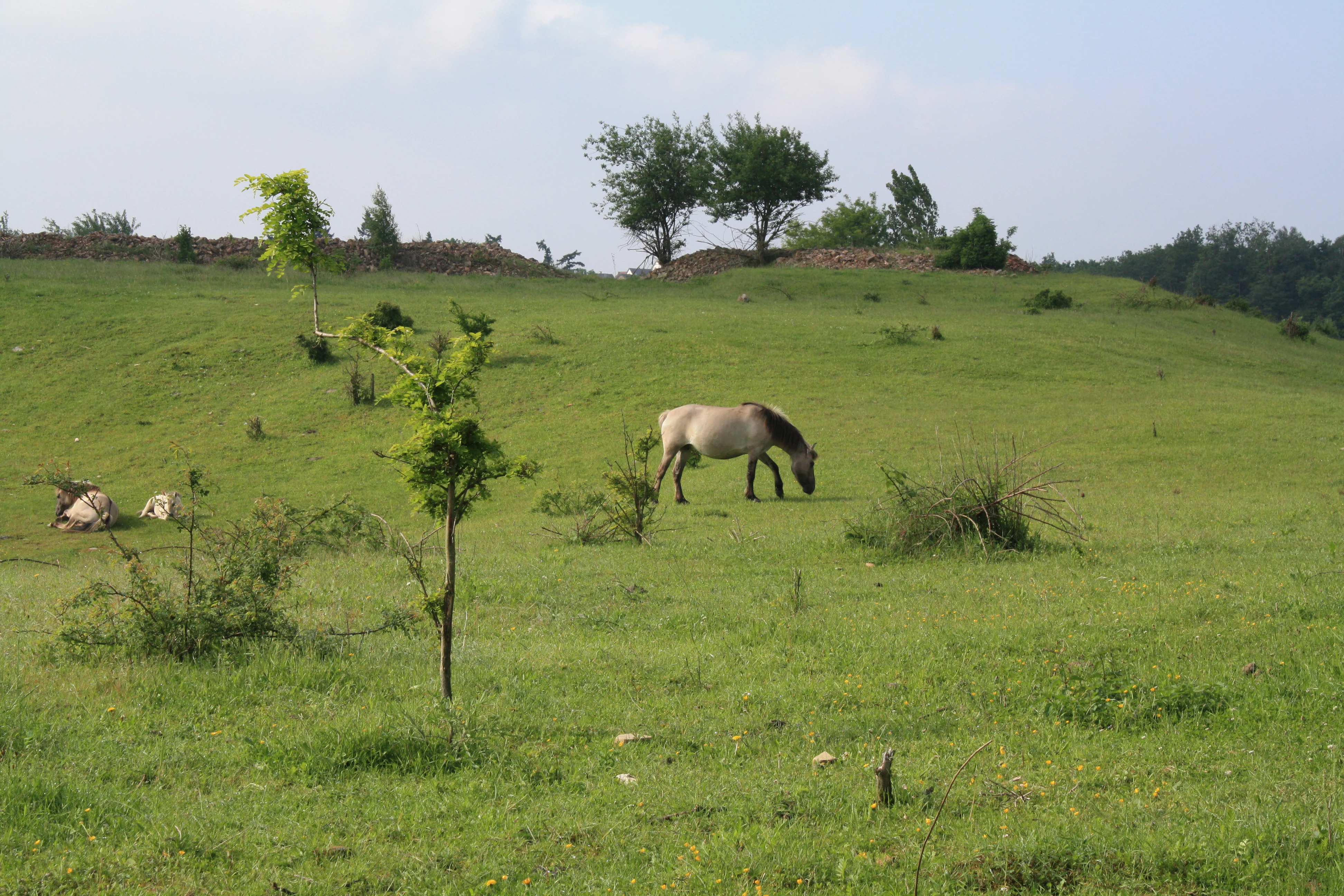
A Konik pony grazes on a green hillside in a nature reserve, with another pony resting in the distance.
Konik ponies grazing in the Steinbühl-Schäfergraben nature reserve.

Steinbühl-Schäfergraben history and protected-area timeline

The history of Steinbühl-Schäfergraben begins not with nature conservation but with hard-rock quarrying. The site was operated as a porphyry quarry, with the local extractor extracting stone from the deposit. After the active phase of extraction came to an end, the plan for the site was typical of the era: backfill the worked-out quarry and then redevelop the land as a commercial or industrial zone.

That trajectory changed when ecological surveys of the abandoned quarry revealed an unusually rich community of plants and animals living on the disturbed ground. Rather than allowing the area to be buried under fill and paving, the Donnersbergkreis, acting as the local nature protection authority, designated the site as a Naturschutzgebiet in 1998, formally committing it to long-term protection for its biological values.

The early years of the reserve brought an unexpected management problem. Without ongoing disturbance, open quarry landscapes in temperate Europe are quickly colonized by shrubs and tree seedlings, and the site began to undergo ecological succession toward woodland. If allowed to continue unchecked, that transition would have erased the very habitat openness on which the reserve's biodiversity depended. Manual control of a roughly 67-hectare site was judged unworkable over the long term.

The solution arrived in 2007, when the reserve launched what became a nationally noted pilot project. Hardy Taurus cattle and Konik wild horses were released onto the site to graze the land year-round, controlling shrub encroachment through their natural behavior. The grazing program proved successful in maintaining open conditions and supporting biodiversity, and the project has since been cited as a model for similar grazing-based reserve management elsewhere in Germany.

Steinbühl-Schäfergraben landscape and geographic character

The landscape of Steinbühl-Schäfergraben is, quite literally, a quarry landscape. The bedrock is porphyry, a hard volcanic rock, and the terrain reflects decades of extraction: exposed rock faces, broken ground, irregular slopes, and a patchwork of sun-heated bare substrate interspersed with pockets of vegetation.

Abandoned quarries in this part of Rhineland-Palatinate often read as scarred land at first glance, but ecologically they are unusual and valuable. Their open, rocky structure retains heat, drains quickly, and resists the dense woodland cover that dominates much of the surrounding Pfalz countryside. The result is a terrain of stone, sparse soils, and open ground that contrasts strongly with the wooded hills typical of the wider region.

The reserve sits north of Kirchheimbolanden, within the rolling countryside of the Donnersbergkreis. From a broader landscape perspective, the Steinbühl-Schäfergraben site appears as an open island within a more forested agricultural region, sustained in that open state primarily through the grazing animals that now define the site's character as a working conservation landscape.
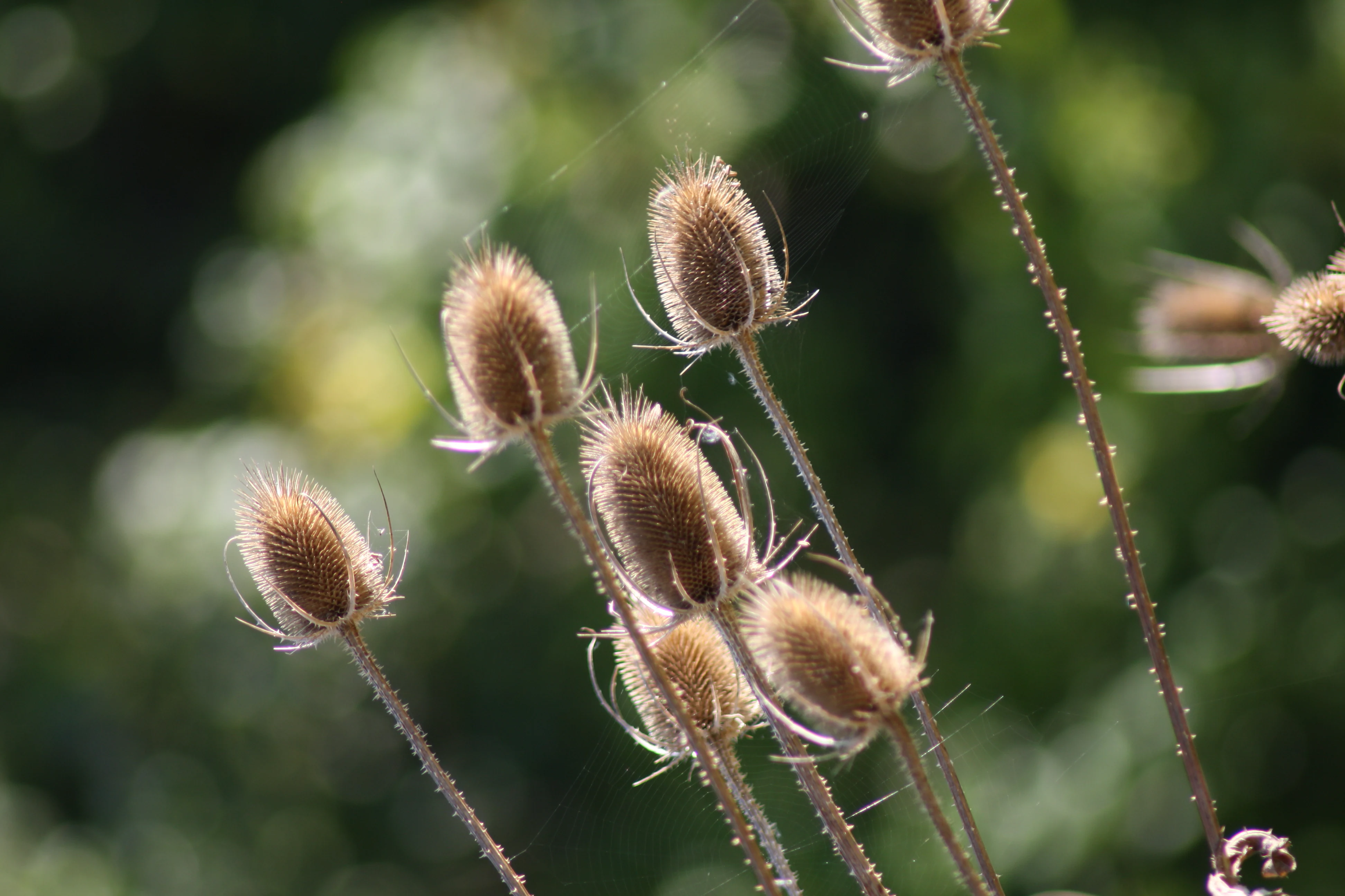
A cluster of prickly, brown dried teasel seed heads against a soft, out of focus green background.
Dried teasel seed heads in the Steinbühl-Schäfergraben nature reserve.

Steinbühl-Schäfergraben ecosystems, habitats, and plant life

Ecologically, Steinbühl-Schäfergraben is defined by its openness and its disturbed, rocky substrate. The porphyry quarry environment provides a kind of surrogate habitat that mimics the dry, warm, open conditions naturally rare in the wetter, more wooded landscapes of inland Rhineland-Palatinate. This makes the reserve unusually diverse for its size, supporting plant communities, insects, amphibians, and other groups that depend on sun-exposed ground, sparse vegetation, and pockets of bare soil.

The reserve's ecological character hinges on maintaining that openness. Without active management, ecological succession would push the site toward shrubland and eventually closed forest, eliminating the very habitat mosaics that justify its protection. The introduction of large grazing animals was specifically intended to interrupt that succession, replicating at much larger scale the kind of disturbance historically provided by wild herbivores or traditional pastoral land use.

By coupling post-industrial terrain with quasi-natural grazing disturbance, the reserve creates an unusual ecological combination: a managed, semi-natural open landscape that continues to host the biodiversity first documented when the area was surveyed prior to protection in 1998.
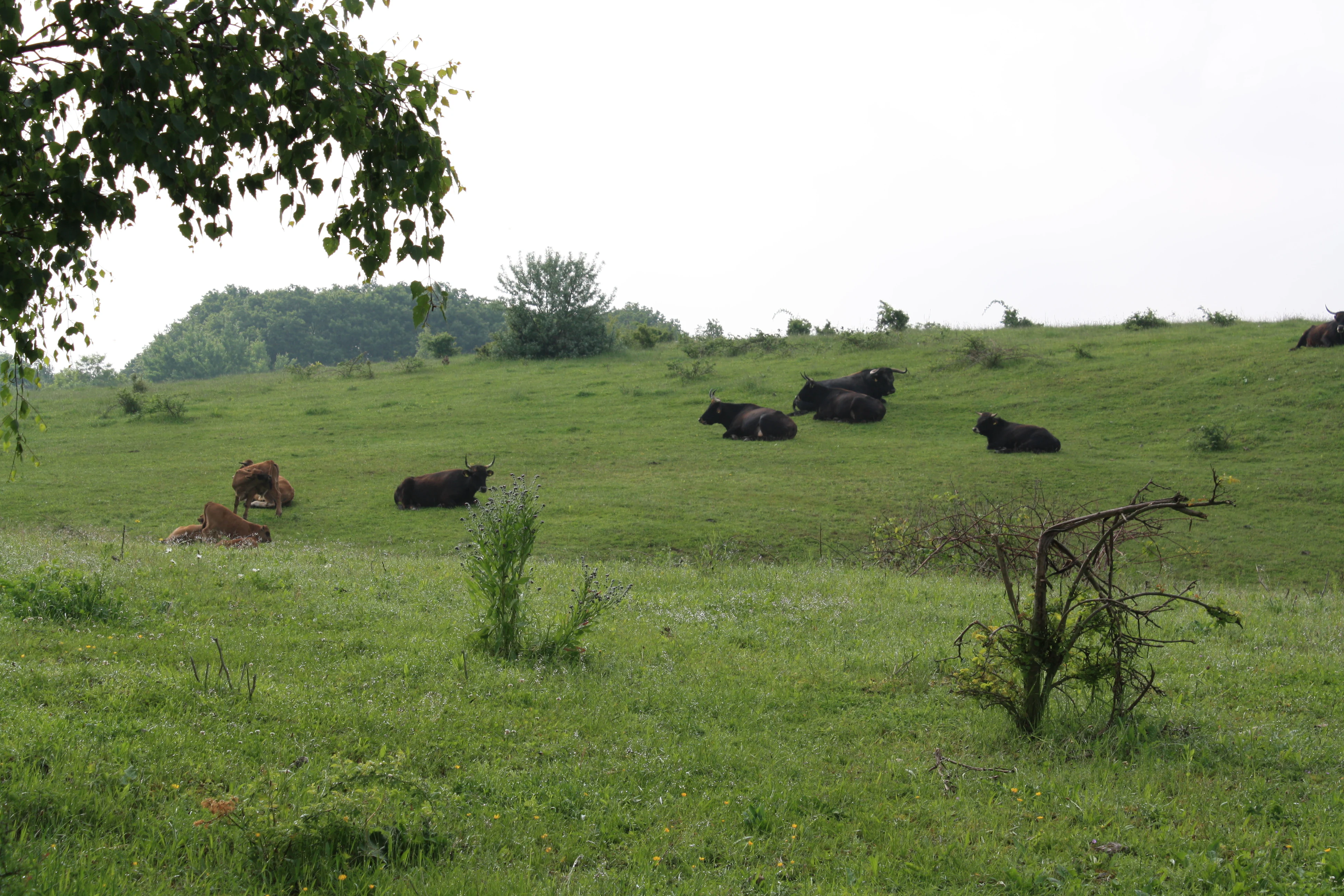
A group of dark-colored cattle resting on a gentle green grassy slope in a nature reserve.
Wild cattle grazing in the Steinbühl-Schäfergraben nature reserve to maintain the open landscape.

Steinbühl-Schäfergraben wildlife and species highlights

Steinbühl-Schäfergraben's wildlife profile reflects the character of its open quarry terrain. The reserve supports plant communities and a range of animal species adapted to dry, sun-exposed, sparsely vegetated ground, conditions that are comparatively rare in the more wooded Pfalz landscape that surrounds it.

In addition to the species that depend directly on the open ground, the reserve is well known for the grazing animals that shape its habitat. Hardy Taurus cattle roam the site alongside Konik wild horses, a robust Polish pony breed often used in European conservation grazing. These animals act less as typical reserve wildlife and more as long-term habitat managers, their grazing, browsing, and movement maintaining the open, non-forested structure that supports the reserve's broader biodiversity.

Amphibians have also been documented on the reserve, consistent with the wet pockets, seeps, and small water features that can develop on former quarry sites. Together, the combination of grazing megafauna, habitat-specific plants, and the small-scale moisture features of the quarry gives Steinbühl-Schäfergraben a varied and recognizable wildlife profile for a reserve of its modest size.
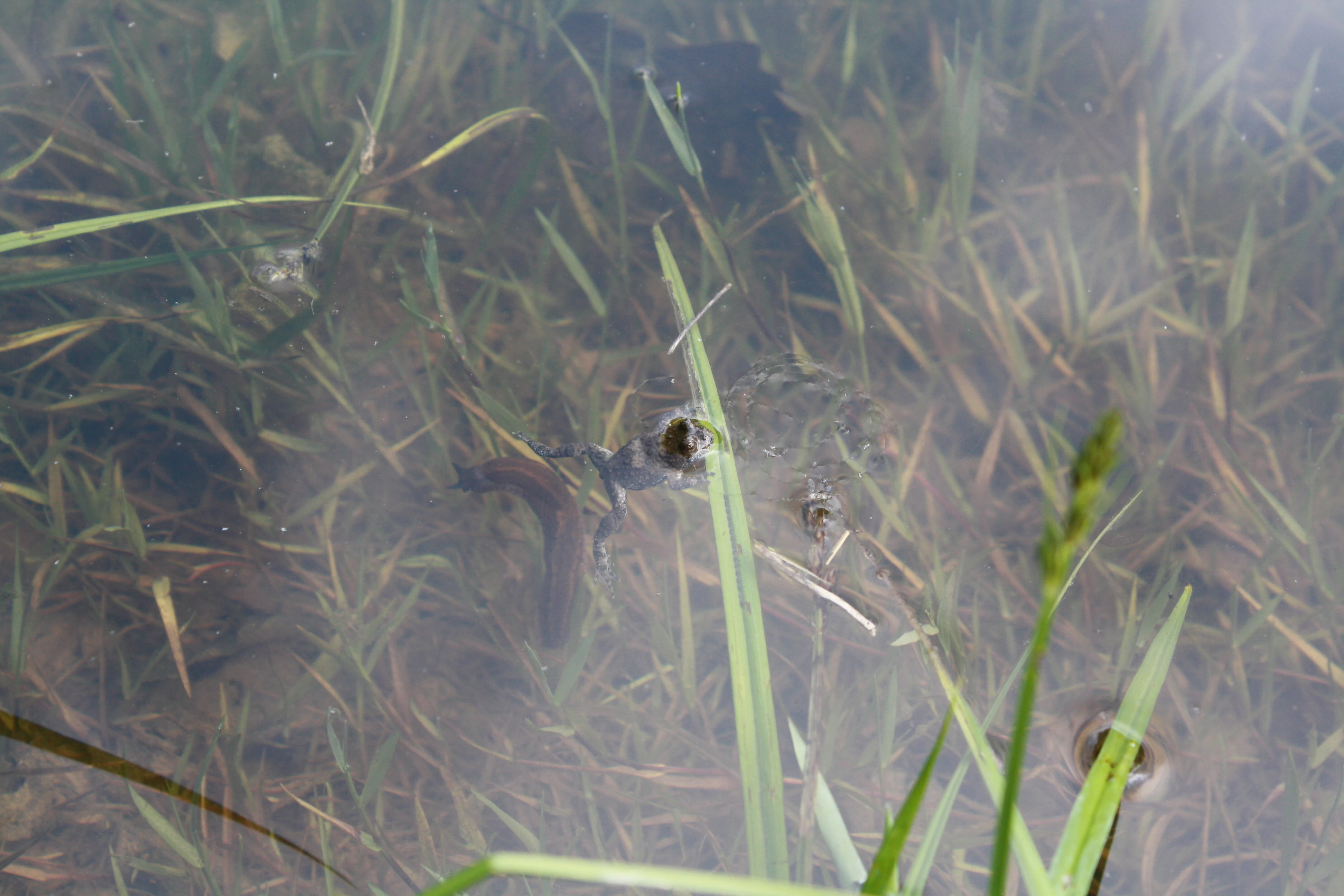
A close-up view of a frog partially submerged in shallow, murky water surrounded by aquatic grasses.
A small frog visible in the shallow, grassy water of the Steinbühl-Schäfergraben nature reserve.

Steinbühl-Schäfergraben conservation status and protection priorities

From a conservation perspective, Steinbühl-Schäfergraben is significant on several levels. First, it represents a successful redirection of post-industrial land: a former quarry that was originally scheduled for backfilling and commercial development, preserved instead after surveys documented an unusually rich biological community. Its designation in 1998 marked a deliberate choice to prioritize long-term biodiversity over short-term economic redevelopment of the site.

Second, the reserve is a widely cited example of conservation through grazing. Beginning in 2007, the management team replaced conventional mechanical maintenance with year-round grazing by Taurus cattle and Konik wild horses, a low-input approach suited to the site's size and challenging terrain. This grazing model has become influential across Germany, with the Steinbühl project cited as a reference point for similar initiatives elsewhere in the country.

Third, the reserve contributes to the conservation of open, dry, sun-exposed habitat types in a region where forestry and agriculture tend to push landscapes toward closure. By maintaining openness and habitat heterogeneity on porphyry quarry ground, Steinbühl-Schäfergraben preserves ecological conditions that would otherwise likely disappear from the surrounding district.

Steinbühl-Schäfergraben cultural meaning and human context

The cultural context of Steinbühl-Schäfergraben is closely tied to the region's industrial and land-use history. Porphyry quarrying shaped the physical ground of the reserve long before conservation did, leaving behind a raw, worked terrain whose later ecological importance was only discovered by survey work conducted ahead of planned commercial redevelopment.

The shift from quarry to nature reserve reflects a wider change in how disturbed sites in Germany are valued. Rather than treating the worked-out quarry as a problem to be erased through backfilling, the Donnersbergkreis chose to protect its newly recognized ecological value, demonstrating how the post-industrial legacy of a region can be redirected toward nature conservation.

The grazing-based management model that emerged from 2007 also carries a cultural resonance, recalling historical patterns of pastoral land use in rural Rhineland-Palatinate, even though the modern Konik and Taurus herds represent a deliberate, science-based rewilding-style approach rather than a continuation of older farming traditions.

Top sights and standout views in Steinbühl-Schäfergraben

Steinbühl-Schäfergraben stands out for combining three distinctive traits: a post-industrial porphyry quarry landscape, an unusually species-rich open habitat for its region, and a pioneering grazing program using Taurus cattle and Konik wild horses. Together these elements make the reserve both a biological asset and a model conservation project.

Its designation in 1998 and its transition to grazing management in 2007 also make it a useful reference point for understanding how former extractive sites can be redirected into long-term ecological value. The reserve's influence extends beyond the Donnersbergkreis, with the Steinbühl project cited as a template for similar grazing-based initiatives elsewhere in Germany.

Best time to visit Steinbühl-Schäfergraben

The reserve is best appreciated in the warmer months, when open-ground plant communities are in active growth and grazing animals are most visible across the quarry terrain. Spring and early summer tend to highlight flowering plants adapted to the dry, sun-exposed quarry ground, while late spring and early summer are generally favorable for observing both flora and the activity of the grazing herds.

Cooler seasons can offer quieter conditions and a different atmospheric quality on the rocky terrain, though the reserve's open, exposed character means it is most visually and ecologically expressive in the warmer half of the year. As with any small protected area managed for biodiversity, visitors should treat the site as a working conservation landscape rather than a conventional recreational destination.

Monthly climate preview

Long-term monthly temperature averages and precipitation patterns for Steinbühl-Schäfergraben

Steinbühl-Schäfergraben Climate Normals and Annual Temperature Rhythm

Representative coordinates track twelve-month temperature variations alongside sustained precipitation rates for Steinbühl-Schäfergraben. Detailed monthly climate records offer complete visibility into long-term averages across the protected area.
Annual mean10 °C
0 °C20 °C
Jan
Feb
Mar
Apr
May14°
Jun18°
Jul20°
Aug20°
Sep15°
Oct10°
Nov
Dec
Warmest month
July

20.4 °C

Coolest month
January

0.3 °C

Wettest month
July

2.2 mm/day

Driest month
April

1.4 mm/day

Park location guide

Geography guide, regional context, and park location map for Steinbühl-Schäfergraben

Steinbühl-Schäfergraben park geography, regions, and map view in Germany

Understand where Steinbühl-Schäfergraben sits in Germany through a broader geographic reading of the surrounding landscape, nearby location context, and its mapped position within the national park landscape.

How Steinbühl-Schäfergraben fits into Germany

Germany is a federal republic in Western and Central Europe with a population of over 83 million across sixteen constituent states. It is Europe's largest economy by nominal GDP and a major global exporter and importer. The capital is Berlin, and the country borders Denmark, Poland, Czech Republic, Austria, Switzerland, France, Luxembourg, Belgium, and the Netherlands.

Wider geography shaping Steinbühl-Schäfergraben in Germany

Germany is located in Western and Central Europe, spanning 357,022 km². It borders Denmark to the north, Poland and the Czech Republic to the east, Austria and Switzerland to the south, and France, Luxembourg, Belgium, and the Netherlands to the west. The country has coastlines on the Baltic Sea and North Sea to the north, with the Alps located in the southern region.

Map view of Steinbühl-Schäfergraben

Use this park location map to pinpoint Steinbühl-Schäfergraben in Germany, understand its exact geographic position, and read its mapped placement within the surrounding landscape more clearly.

Pigeon | © OpenStreetMap contributors

Location context for Steinbühl-Schäfergraben

DonnersbergkreisRhineland-Palatinate

Visualizing the post-industrial terrain and open habitats of this protected reserve

Steinbühl-Schäfergraben Photos and Landscape Scenery

Visual records capture the exposed porphyry rock faces, sparse soils, and open terrain that define the unique character of the Steinbühl-Schäfergraben nature reserve. Examining these field photographs reveals how conservation grazing maintains open habitats across the former quarry landscape.

A Konik pony grazes on a green hillside in a nature reserve, with another pony resting in the distance.

A close-up photograph of a vibrant pink campion-like flower in focus, with a soft-focus green and light purple blurred background.

A cluster of prickly, brown dried teasel seed heads against a soft, out of focus green background.

A group of dark-colored cattle resting on a gentle green grassy slope in a nature reserve.

A close-up view of a frog partially submerged in shallow, murky water surrounded by aquatic grasses.

Park atlas

Compare regional geography and discover other protected areas in the surrounding terrain

Explore Parks Near Steinbühl-Schäfergraben and Related Protected Landscapes

Browse nearby nature reserves and regional conservation areas to compare distinct geological terrains and habitat management methods. Expanding the search beyond Steinbühl-Schäfergraben reveals broader ecological patterns across the surrounding district and wider region.
A soft watercolor painting depicting a rolling landscape with fields, a small forest edge, and a mountain peak in the background.
Protected areaRhineland-Palatinate
Mapped location lies within the park boundary#1 closest

Southwest

Donnersberg Protected Area: A Geographic Atlas of the Palatinate Region's Highest Massif

Geological landscapes, Celtic heritage sites, and forested mountain terrain.

The Donnersberg massif represents a critical point of geographic and archaeological interest in Rhineland-Palatinate. This protected area encompasses a 24-square-kilometer rhyolite cryptodome featuring high-altitude plateaus, a complex network of forest ecosystems, and well-preserved remnants of ancient Celtic fortifications. Its steep slopes and diverse rock formations offer a clear look at the geological and historical layering of the German landscape.

Area
24 km²
Relief
Mountain
Climate
Temperate
Access
Easy access
Nature reserveRheinland-Pfalz
About 9 km away#2 closest

Southwest

Spendel-Wildenstein Nature Reserve: Protected Forest Boundaries and Regional Geography

Deciduous forest reference area in the Donnersbergkreis district

Discover the geographic and ecological structure of Spendel-Wildenstein, a 145-hectare protected forest area in Germany. This nature reserve serves as a crucial natural forest reference site, known for its layered woodland communities, including rare Montpellier maple-oak and maple-ash stands situated along the Wildensteiner Bach stream valley.

Area
1.45 km²
Established
1981
Protected landscapeRhineland-Palatinate
About 9.7 km away#3 closest

North

Rheinhessische Schweiz: Protected Landscape and Regional Geography in Rhineland-Palatinate

Forested ridges and dry heathland terrain

Rheinhessische Schweiz represents a significant protected area defined by its dense deciduous forests, narrow valleys, and nutrient-poor porphyry soils. This atlas entry details the geographic composition of the Wiesener Randhöhen and the Neubamberger Riegel, highlighting the unique dry grassland ecosystems preserved within these North Palatine Uplands boundaries.

Area
67.66 km²
Established
1961
Relief
Upland
Climate
Temperate
Nature reserveDonnersbergkreis
About 12 km away#4 closest

Southwest

Beutelfels Nature Reserve: Geographic Insights and Protected Landscape Mapping

A diverse forested landmark in the Donnersbergkreis district

Located in the Falkensteiner Berge range, Beutelfels represents a significant protected area within the German landscape. The reserve showcases a dense integration of maple-linden forests and open rocky outcrops, preserved as a dedicated forest reference plot. Discover the unique topography and ecological zoning that define this essential 59-hectare segment of the Nordpfälzer Bergland.

Area
0.59 km²
Established
1981
Relief
Mountain
Climate
Temperate
Nature reserveDonnersbergkreis
About 13 km away#5 closest

West

Langhöll-Falkenberg Nature Reserve and Protected Landscape in Donnersbergkreis

Mapping the ecological gradient of this North Palatine valley reserve.

Langhöll-Falkenberg represents a distinct protected zone where dry upland slopes meet moist valley floor environments. The reserve functions as an essential habitat mosaic, combining semi-dry grasslands with alder carr and spring-fed mires. This structured view examines the site topography and its role in regional conservation across the North Palatine uplands of Rhineland-Palatinate.

Area
1 km²
Established
1999
IUCN
IV
A soft, light watercolor painting of a rolling rural landscape featuring rows of vineyards in the foreground and tree-covered hills in the distance.
Nature reserveRheinland-Pfalz
About 16 km away#6 closest

Southeast

Haardtrand Nature Reserve: Geographic Overview and Protected Landscape Mapping

Bird protection area within the Rheinland-Pfalz region.

Spanning roughly 14,700 hectares, Haardtrand serves as a critical link between the Palatinate Forest and the Rhine valley. This nature reserve is composed of a distinctive mosaic of habitat types, including mature broadleaf woodlands, traditional orchard meadows, and sandy terraces, which together create a highly structured environment for diverse raptors and forest-dwelling bird species.

Area
147.28 km²
Established
2004
Nature reserveRheinland-Pfalz
About 17 km away#7 closest

Northeast

Gau-Köngernheimer Ried Nature Reserve: Map and Protected Landscape Geography

A protected wetland mosaic in the Selz river valley of Rheinland-Pfalz

Gau-Köngernheimer Ried represents an ecologically vital nature reserve in the Alzey-Worms district. Its landscape is defined by a low-lying floodplain, featuring reed-fringed ditches, pollarded trees, and moist hay meadows that follow the course of the Selz river. The site functions as a key component of the regional habitat network within the agricultural landscape of southwestern Germany.

Area
0.29 km²
Established
1990
Relief
Lowland
Climate
Temperate
A soft, painterly watercolor illustration depicting a winding river flowing through a lush green valley with rolling hills in the background.
Nature reserveRheinland-Pfalz
About 19 km away#8 closest

Northeast

Im Briehl/Schafwiese Nature Reserve: Selz River Floodplain and Wetland Geography

A restored riverine landscape in Rheinland-Pfalz

The Im Briehl/Schafwiese nature reserve is a protected fragment of the Selz river floodplain in Rheinland-Pfalz. This site is defined by its 2020 to 2021 renaturation, which replaced straight channels with a meandering course, creating a mosaic of damp meadows, reed beds, and still-water biotopes within an agricultural landscape.

Area
0.23 km²
Established
1990

Common questions about visiting, size, designation, and location context for Steinbühl-Schäfergraben

Steinbühl-Schäfergraben FAQs for park facts, access, geography, and protected area context

Find quick answers about Steinbühl-Schäfergraben, including protected-area facts, park geography, trail and visitor context, and how the park fits into its surrounding country and regional landscape.
MoriAtlas Explorer

Continue Your Protected Areas Search Across the Global Atlas

Deepen your exploration by continuing the structured search for national parks and protected areas worldwide. Utilize the comprehensive filtering capabilities to compare different conservation landscapes and refine your understanding of global park geography. Discover more about the distribution and characteristics of protected natural areas.

Global natural geography