Mori Atlas logo
Nature reserveSteinhuder Meer mit Randbereichen

A detailed look at the hydrology, reedbeds, and bog terrain of this major German lowland wetland.

Steinhuder Meer mit Randbereichen Nature Reserve: Mapped Protected Landscapes in Lower Saxony

(FFH-Gebiet Steinhuder Meer (mit Randbereichen))

Steinhuder Meer mit Randbereichen represents a significant wetland complex in Lower Saxony, defined by the shallow waters of Lake Steinhuder Meer and its surrounding marshy margins. The area provides a critical mosaic of reedbeds, wet meadows, and raised bog habitats that serve as a vital corridor within the Weser-Aller lowlands. This atlas view traces the protected boundaries and regional terrain that sustain international waterbird populations and diverse shore-dwelling species.

lakelowland wetlandreedbedswet meadowsraised bogNatura 2000

Steinhuder Meer mit Randbereichen

Nature reserve

Park overview

Structured park overview, official facts, and landscape profile for Steinhuder Meer (with Randbereichen)

Steinhuder Meer (with Randbereichen) park facts, protected area profile, and essential visitor context

Review the core facts for Steinhuder Meer (with Randbereichen), including designation, size, terrain, visitor scale, habitats, and operating context in one park-focused overview.

About Steinhuder Meer (with Randbereichen)

Steinhuder Meer (mit Randbereichen) is a Natura 2000 protected landscape in northern Germany that centers on Lake Steinhuder Meer, one of the largest lakes in Lower Saxony. The designation unites the open water of the lake with three surrounding nature reserves in a single ecologically managed complex. To the west lie the Westufer Steinhuder Meer and Meerbruchswiesen reserves, and to the east lies the Totes Moor reserve. Together, they form a buffer of habitats that connects the lake's open water to the surrounding lowland farmland.

The site sits within the Weser-Aller flatlands at the transition between the Middle Weser Valley, the Hannover Bog Geest, and the Lockum Geest. This transitional position gives the protected area a distinctive mix of habitats. The lake itself is shallow and nutrient-rich, with extensive submerged and floating vegetation, while the surrounding margins include degraded raised bog, fen meadows, alluvial grasslands, and patches of oak and mixed forest. The combination of habitats reflects a history of peat cutting, traditional grassland management, and gradual ecological restoration.

The protected area is recognized at the European level through both the EU Habitats Directive and the EU Birds Directive. It serves as a refuge for wetland species that have become scarce across the wider intensively farmed and urbanized landscape of Lower Saxony. The overlapping designation as a Bird Protection Area highlights its importance for migratory waterfowl and for breeding bird communities tied to undisturbed reedbeds and quiet forest stands. For visitors and researchers, the area represents one of the most ecologically significant freshwater wetland complexes in northwestern Germany.

Quick facts and research context for Steinhuder Meer (with Randbereichen)

Steinhuder Meer (mit Randbereichen) is a designated Natura 2000 site in Lower Saxony that combines a Habitat Directive area (FFH-Gebiet) with an overlapping Bird Protection Area (Vogelschutzgebiet). It covers the open water of Lake Steinhuder Meer together with three surrounding nature reserves: Westufer Steinhuder Meer, Meerbruchswiesen, and Totes Moor.

The site lies within the natural regions of the Middle Weser Valley, the Hannover Bog Geest, and the Lockum Geest, parts of the broader Weser-Aller lowland landscape. It was proposed as an FFH site in June 2000 and formally confirmed in December 2004, while the bird protection area was reorganized in 2001. The area is administered in connection with the Lower Saxony water and nature management authority.

Protection and recognition

Documented Natura 2000 designations and official conservation records

Steinhuder Meer mit Randbereichen Protection Status and Recognition

Protected area records for Steinhuder Meer mit Randbereichen detail official Natura 2000 recognition and administrative boundaries. Structured conservation data provides reliable context on international designations and legal protection frameworks.
Park context

Deeper park guide and search-rich context for Steinhuder Meer (with Randbereichen)

Steinhuder Meer (with Randbereichen) history, landscape, wildlife, and travel context

Explore Steinhuder Meer (with Randbereichen) through its history, landscape character, ecosystems, wildlife, conservation priorities, cultural context, and seasonal travel timing in a structured park guide built for atlas discovery and search intent.

Why Steinhuder Meer (with Randbereichen) stands out

Steinhuder Meer (mit Randbereichen) is best known for its combination of a large, shallow lowland lake with a rich border of reedbeds, wet meadows, and bog fragments. The site stands out as a wetland of international importance for waterbirds, with significant numbers of grebes, cormorants, divers, ducks, geese, and gulls using the lake as a resting and moulting area. It is also notable for its reed-breeding bird communities, including water rail, spotted crake, and sedge warbler, and for the forest pockets along the shore that host species such as grey-headed woodpecker, red and black kites, and nightjar. The mix of open water, fen meadows, and degraded raised bog gives the area a layered ecological character that is unusual within the surrounding intensively used lowlands.
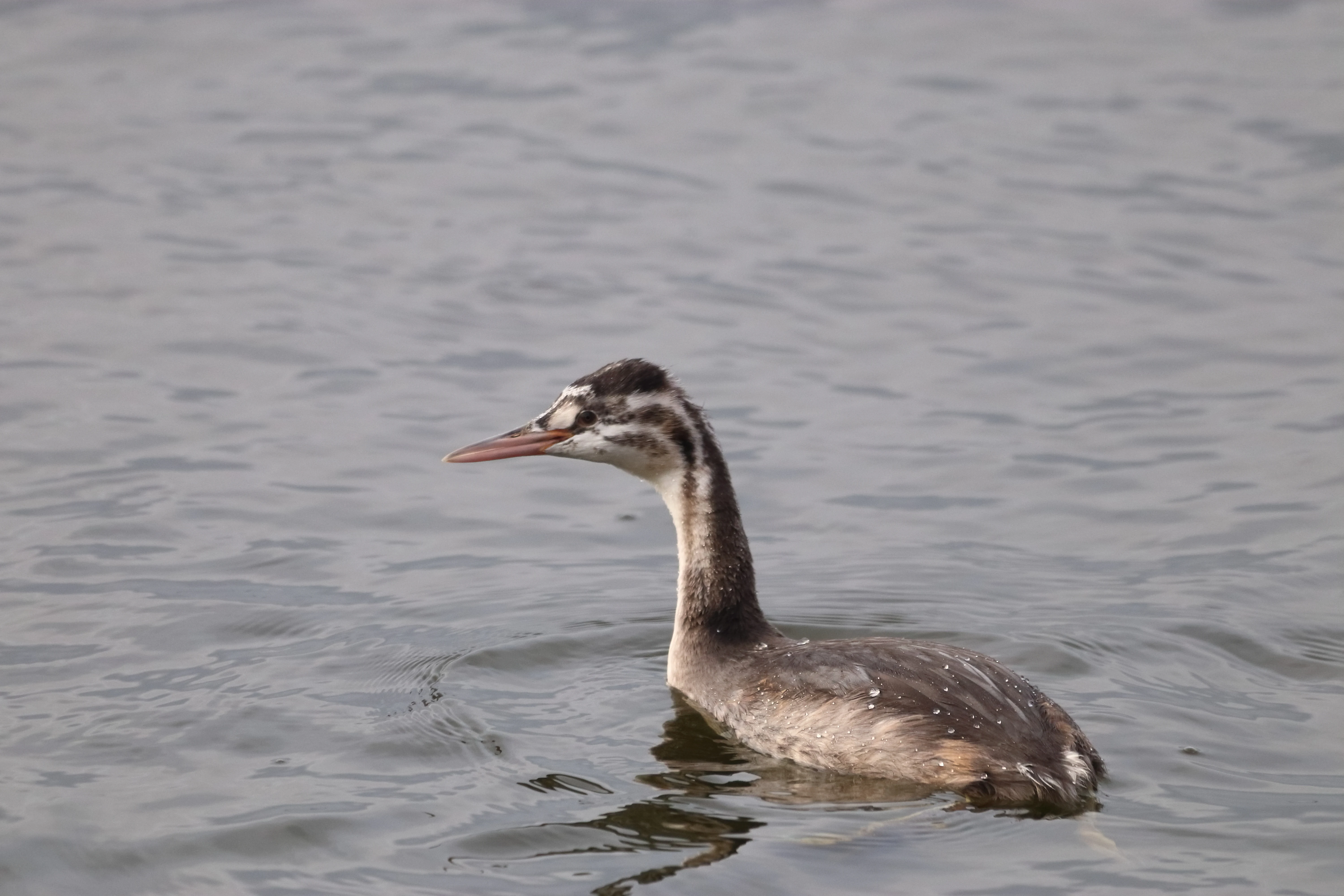
A juvenile Great Crested Grebe with characteristic striped head markings swimming on calm, gray water.
A young Great Crested Grebe swimming on the waters of Steinhuder Meer.

Steinhuder Meer (with Randbereichen) history and protected-area timeline

The protection history of the Steinhuder Meer area stretches back several decades. A precursor bird protection area was already established in 1983, reflecting early recognition of the lake's value for waterbirds and reed-breeding species. This earlier designation was reorganized and re-delimited in June 2001 to align with updated European criteria.

The Habitats Directive area, Steinhuder Meer (mit Randbereichen), was proposed in June 2000 and formally confirmed in December 2004. Its definition emphasizes the combination of a large shallow lake, near-natural shoreline transitions, grassland on fen soils, and raised bog fragments that have been altered in part by peat extraction. The site is administered in cooperation with the Lower Saxony state authority for water management, coastal protection, and nature conservation.

Over time, conservation efforts within and around the protected area have focused on preserving the remaining peatland and reed habitats, maintaining traditional grassland use where appropriate, and supporting breeding populations of rare birds. The protected area now sits within an evolving framework of European and national nature conservation policy, while continuing to function as a working landscape shaped by centuries of peat cutting, farming, and water level management.

Landscape note: The historical use of the peatlands, particularly the Totes Moor, has left a visible imprint on the landscape, with cutover and regenerating bog areas forming a distinctive part of the site's character.

Steinhuder Meer (with Randbereichen) landscape and geographic character

The landscape of Steinhuder Meer (mit Randbereichen) is defined by the contrast between open water and its surrounding lowland margins. Lake Steinhuder Meer itself is a large, very shallow body of water with low banks and broad shallow shorelines. Gentle gradients and exposed shallow areas shape both the hydrology and the visual character of the lake.

The western margin is shaped by the Westufer Steinhuder Meer reserve and the Meerbruchswiesen, where wet grassland, reedbeds, and shallow embayments create an irregular shoreline with numerous quiet bays and channels. To the east, the Totes Moor forms a contrasting landscape of peatland, with open bog remnants, cutover areas, and regeneration zones. These two flanking areas give the protected site an east-west gradient from open water through grassland to bog.

Patches of deciduous and mixed woodland on sandy soils add further structure to the shore. Beyond the protected area, the landscape continues into the flatter parts of the Weser-Aller lowlands, an agricultural setting in which the lake and its margins stand out as a large, green-blue interruption. The overall impression is of a broad, soft lowland lake framed by wetland and bog scenery rather than steep or dramatic landforms.
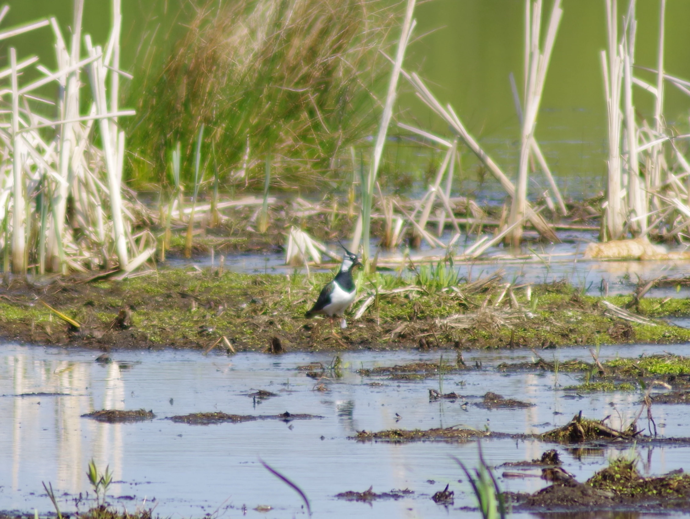
A Northern Lapwing standing on a small muddy island surrounded by shallow water and reeds.
A Northern Lapwing stands in the wetland habitat of the Meerbruch nature reserve.

Steinhuder Meer (with Randbereichen) ecosystems, habitats, and plant life

Ecologically, Steinhuder Meer (mit Randbereichen) functions as an integrated wetland complex. The lake contributes a large share of nutrient-rich standing water habitat with characteristic pondweed and frogbit vegetation, while the surrounding moors and meadows contribute peatland, transitional mire, wet grassland, and alder- and oak-dominated woodland.

Biotope composition within the FFH area shows a clear dominance of standing water, complemented by raised and transitional bog, intensive grassland, smaller areas of arable land, and fragments of broadleaf and mixed forest. The mix supports a chain of habitat types from open water through reed and fen to dry sandy woodland. These habitats interlock closely because of the flat topography and the gradual transitions between lake, marsh, and bog.

Several Annex I habitat types of the EU Habitats Directive are represented, including natural and near-natural nutrient-rich standing water bodies, renaturable degraded raised bogs, bog woodlands, lowland hay meadows, transition mires and quaking bogs, old acidophilous oak forests on sandy soils, and eutrophic tall herb vegetation. The presence of dystrophic standing waters and small patches of very sensitive peatland communities underlines the ecological variety within a relatively compact area.
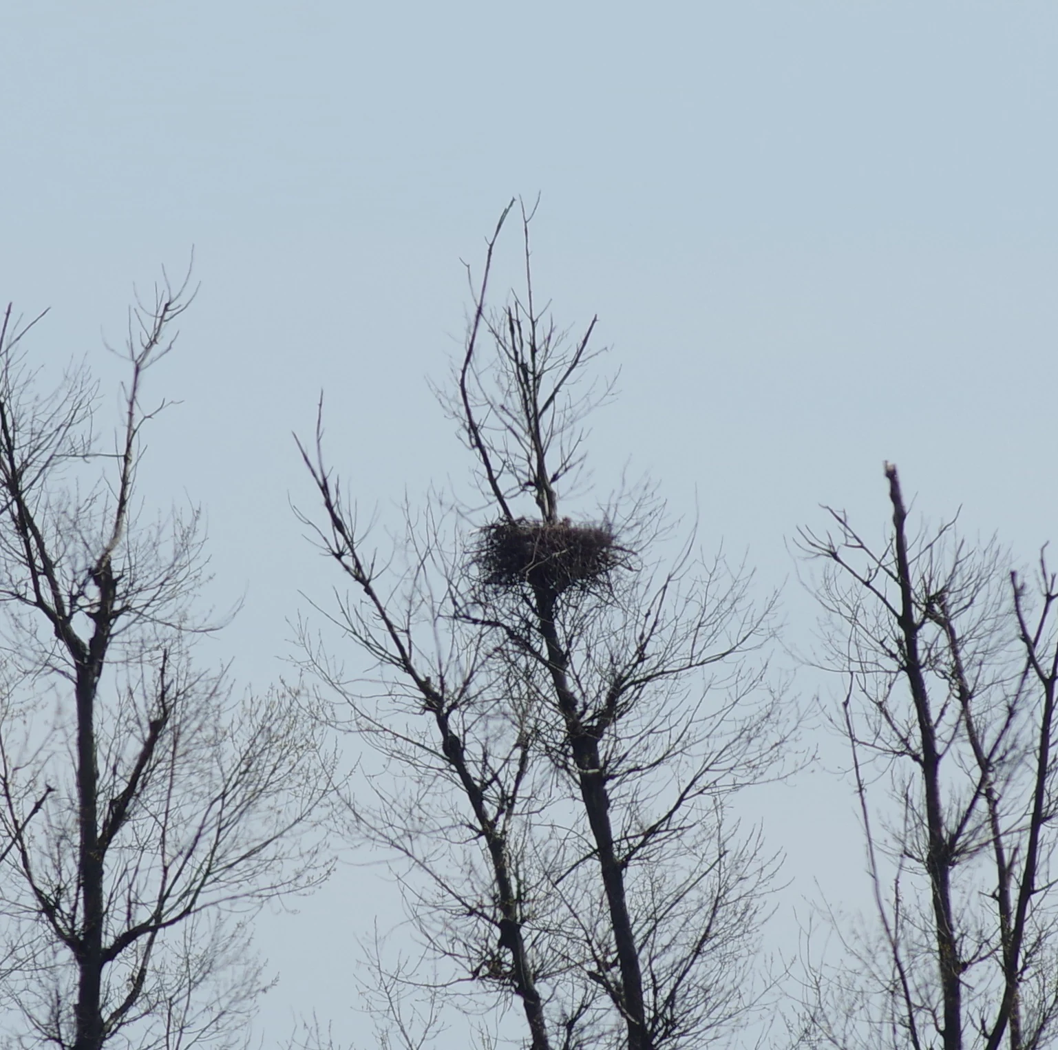
A large nest made of twigs sits high up in the bare, leafless branches of a tall tree against a pale, overcast sky.
A bird nest situated high in a bare tree within the Meerbruch nature reserve.

Steinhuder Meer (with Randbereichen) wildlife and species highlights

The wildlife profile of Steinhuder Meer (mit Randbereichen) is shaped strongly by its wetland character. The lake is an important habitat for the great crested grebe, along with cormorants, divers, sawbills such as smew and goosander, and a wide range of ducks, geese, and gulls, many of which use the area for resting, feeding, and moulting.

Reed-breeding birds are another key component of the site's fauna. Species such as the water rail, spotted crake, and sedge warbler depend on the extensive reedbeds that line parts of the shoreline. The quieter forest patches around the lake support breeding populations that depend on structurally rich, undisturbed woodland, including the grey-headed woodpecker, red kite, and black kite. Open and semi-open landscapes in the bog margins host species such as whinchat and nightjar.

Beyond birds, the site is home to a range of other protected and rare species. Amphibians associated with the wetland include the European tree frog, common spadefoot toad, and moor frog, while reptile records include the smooth snake and sand lizard. Fish species of conservation interest include the spined loach and weatherfish. The pond bat is present among the mammal fauna, and indirect evidence suggests occasional use of the area by the Eurasian otter. Invertebrates include the mercury bluet damselfly, while vascular plants of conservation interest include soft bog orchid in the bog margins.

Steinhuder Meer (with Randbereichen) conservation status and protection priorities

Steinhuder Meer (mit Randbereichen) holds significant conservation value because it protects a large, comparatively intact wetland complex within an otherwise intensively used lowland region. Its combined status under the EU Habitats Directive and the EU Birds Directive reflects both the quality of its habitat types and its importance for protected species.

From a habitat perspective, the site maintains a chain of rare Annex I types, including degraded but restorable raised bog, transition mires, bog woodland, lowland hay meadows, and old oak forest on sandy soils. The large open water body adds a standing freshwater component that supports characteristic aquatic vegetation. Together, these habitats form a connected gradient that is unusual in the regional context and gives the area high ecological coherence.

From a species perspective, the area is notable for its breeding populations of reed-dependent and woodland-dependent birds, its waterbird concentrations during migration and winter, and its populations of protected amphibians, fish, bats, and invertebrates. As a recognized wetland of international importance, the area is a focal site for waterbird conservation in Lower Saxony and contributes to broader European conservation networks through Natura 2000.

Steinhuder Meer (with Randbereichen) cultural meaning and human context

Steinhuder Meer has long been a defining feature of the local landscape and identity in the Hannover Region and Nienburg district. The lake and its surrounding meadows and bogs have shaped local land use for centuries, through fishing, peat cutting, and traditional grassland management. The persistent presence of these practices is part of the reason that habitats such as lowland hay meadows and remnant bog landscapes still exist alongside modern agriculture.

The region around the lake also carries recreational and landscape-cultural meaning, with the lake and its shores forming a well-known setting for local life in northern Lower Saxony. The protected area reflects an effort to conserve both the natural and the long-influenced cultural landscape, recognizing that many of its habitats are maintained by continuing human activity rather than purely by abandonment.

Top sights and standout views in Steinhuder Meer (with Randbereichen)

Steinhuder Meer (mit Randbereichen) stands out for its combination of a large shallow lowland lake, extensive reed belts, fen meadows, and degraded raised bog. It functions both as a habitat site under the EU Habitats Directive and as a Bird Protection Area of European importance, supported by overlapping national nature reserves on the western and eastern shores.

The site is particularly notable for its waterbird concentrations, its breeding populations of reed-dependent birds, and its quiet shore woodlands that support species of European conservation interest. Its ecological richness is anchored in a chain of habitats, from open water and reedbed to bog woodland and dry oak forest, all within a single protected area.

Best time to visit Steinhuder Meer (with Randbereichen)

The ecological character of the Steinhuder Meer (mit Randbereichen) area changes with the seasons. Late winter and spring bring concentrations of resting and returning waterfowl, as well as the early breeding season for waterbirds and amphibians in the surrounding wet meadows and bogs.

Late spring and early summer are when the reed-breeding bird communities are most active, and when lowland hay meadows in the western reserves reach their floristic peak. Late summer and autumn bring moulting waterfowl and the start of autumn migration, while frost and mist in winter can transform the lake into a quiet, atmospheric wetland landscape with congregations of wildfowl on the open water. Visit timing should focus less on operational logistics and more on which seasonal ecological character is most valued.

Monthly climate preview

Long-term temperature and precipitation patterns across representative coordinates

Steinhuder Meer mit Randbereichen Climate Normals and Monthly Weather Profile

Historical climate records for Steinhuder Meer mit Randbereichen trace measured monthly temperature ranges alongside consistent daily precipitation averages across the representative coordinate. Detailed twelve-month climatology data allows thorough examination of annual weather variations within Lower Saxony protected landscapes.
Annual mean9 °C
1 °C18 °C
Jan
Feb
Mar
Apr
May13°
Jun16°
Jul18°
Aug18°
Sep14°
Oct10°
Nov
Dec
Warmest month
July

18.4 °C

Coolest month
January

0.6 °C

Wettest month
July

2.4 mm/day

Driest month
April

1.4 mm/day

Park location guide

Geography guide, regional context, and park location map for Steinhuder Meer (with Randbereichen)

Steinhuder Meer (with Randbereichen) park geography, regions, and map view in Germany

Understand where Steinhuder Meer (with Randbereichen) sits in Germany through a broader geographic reading of the surrounding landscape, nearby location context, and its mapped position within the national park landscape.

How Steinhuder Meer (with Randbereichen) fits into Germany

Germany is a federal republic in Western and Central Europe with a population of over 83 million across sixteen constituent states. It is Europe's largest economy by nominal GDP and a major global exporter and importer. The capital is Berlin, and the country borders Denmark, Poland, Czech Republic, Austria, Switzerland, France, Luxembourg, Belgium, and the Netherlands.

Wider geography shaping Steinhuder Meer (with Randbereichen) in Germany

Germany is located in Western and Central Europe, spanning 357,022 km². It borders Denmark to the north, Poland and the Czech Republic to the east, Austria and Switzerland to the south, and France, Luxembourg, Belgium, and the Netherlands to the west. The country has coastlines on the Baltic Sea and North Sea to the north, with the Alps located in the southern region.

Map view of Steinhuder Meer (with Randbereichen)

Use this park location map to pinpoint Steinhuder Meer (with Randbereichen) in Germany, understand its exact geographic position, and read its mapped placement within the surrounding landscape more clearly.

Pigeon | © OpenStreetMap contributors

Location context for Steinhuder Meer (with Randbereichen)

Lower Saxony

Visualizing the lowland lake shores, reedbeds, and bog habitats of Lower Saxony

Steinhuder Meer mit Randbereichen Photos: Scenery and Protected Landscapes

Examine detailed photography highlighting the open water, wetland margins, and diverse shore habitats of Steinhuder Meer mit Randbereichen. Visual documentation reveals the ecological structure of the lake basin, surrounding nature reserves, and protected lowland scenery.

A juvenile Great Crested Grebe with characteristic striped head markings swimming on calm, gray water.

A grey heron standing in shallow water among tall reeds at the edge of a lake.

A Northern Lapwing standing on a small muddy island surrounded by shallow water and reeds.

A large nest made of twigs sits high up in the bare, leafless branches of a tall tree against a pale, overcast sky.

Park atlas

Compare surrounding lowland wetlands and regional conservation landscapes

Explore Protected Areas and Parks Near Steinhuder Meer mit Randbereichen

Browse other parks and protected areas located near Steinhuder Meer mit Randbereichen to examine regional habitat connections. Extend your geographical comparison across neighboring lowland reserves and wetland ecosystems within the Weser-Aller region.
Nature reserveLower Saxony
Mapped location lies within the park boundary#1 closest

Southwest

Westufer Steinhuder Meer Nature Reserve: Geographic Profile and Wetland Boundaries

Protected mosaic of swamp forest and bog in Lower Saxony

Westufer Steinhuder Meer represents a significant wetland complex within the Natura 2000 network of Lower Saxony. The protected area features a unique concentric gradient ranging from lakeshore reedbeds to inland fen and bog forest. By mapping these interconnected peat habitats, the reserve highlights its role as a key stopover for migratory waterfowl and a sanctuary for rare breeding species on the North German Plain.

Area
6.63 km²
Established
2020
A wide panoramic watercolor illustration showing a winding river or stream flowing through a landscape of green pine trees and pink flowering bushes under a pale sky.
Nature reserveRegion Hannover
About 5.1 km away#2 closest

East

Wadebruch Nature Reserve: Geographic Analysis of a Lower Leine Floodplain Protected Area

A dense mosaic of alder swamps, oxbow channels, and sandy terrace forest in Germany.

Wadebruch serves as a compact, ecologically rich example of a lower Leine floodplain environment. Located in the Hannover Region, this protected site preserves a historic river meander, including an aging oxbow and alder swamp forest, contrasted against steep sandy banks. The site provides essential insights into the natural river patterns that once characterized this part of Lower Saxony.

Area
0.16 km²
Established
1985
IUCN
IV
Relief
Lowland
Nature reserveNienburg/Weser
About 6.6 km away#3 closest

Northwest

Wellier Schleife/Staustufe Landesbergen: A Protected River Oxbow and Floodplain Geography

Mapping protected habitats in the Middle Weser valley of Germany.

This nature reserve protects the Wellier Schleife, a significant oxbow arm created by the Landesbergen weir. The 278-hectare area encompasses former gravel pits, wetland fringes, and agricultural floodplains. It stands as a vital component of the Wesertalaue bei Landesbergen bird protection network, reflecting the interplay between river engineering and conservation efforts.

Area
2.78 km²
Established
1996
IUCN
IV
Relief
Lowland
Protected areaRegion Hannover
12 km away#4 closest

Southeast

Mausohr-Wochenstube bei Barsinghausen: Protected Habitat and Regional Landscape Context

A vital Natura 2000 maternity site in Region Hannover

Examine the geography of Mausohr-Wochenstube bei Barsinghausen, an essential protected area for greater mouse-eared bats. This site showcases the intersection of architectural heritage and natural conservation, relying on the adjacent river corridors and agricultural landscapes of the Region Hannover to sustain its vital ecological function within Lower Saxony.

Area
0.001 km²
Established
2004
Relief
Lowland
Climate
Temperate
Nature reserveNordrhein-Westfalen
About 12 km away#5 closest

West

Weseraue Nature Reserve and Weser River Floodplain Geographic Overview

Protected wetland landscapes in North Rhine-Westphalia

The Weseraue landscape encompasses 25 kilometers of the Weser river corridor, characterized by its diverse mix of dammed sections, natural flow channels, and seasonal wet grasslands. As a cornerstone of the Natura 2000 network, it provides essential habitat for breeding and migratory species, serving as a primary refuge within the North Rhine-Westphalia floodplain geography.

Area
27.438 km²
Established
1983
Relief
Lowland
Scope
Terrestrial
Watercolor illustration of a peaceful lakeside scene at Lahder Marsch, featuring birch trees, marshy vegetation, and a calm water surface.
Nature reserveKreis Minden-Lübbecke
About 18 km away#6 closest

Southwest

Lahder Marsch Nature Reserve: Protected Wetland Mosaic in Kreis Minden-Lübbecke

A mapped sanctuary for migratory birds within the Weser floodplain.

Lahder Marsch is a designated nature reserve located in the Weser river valley, forming a chain of flooded gravel pits that sustain diverse avian populations. This protected landscape, characterized by open water, islands, and dense reed fringes, serves as a crucial habitat within the larger Weseraue Natura 2000 network, illustrating the geographic importance of restored extraction sites in lowland Germany.

Area
0.19 km²
Water
Major water bodies
A horizontal watercolor painting depicting a soft, impressionistic forest landscape with green trees, subtle hints of pink and purple, and a light background.
Nature reserveNorth Rhine-Westphalia
19 km away#7 closest

Southwest

Heisterholz: Protected Oak Forests and Wetland Mosaics in North Rhine-Westphalia

Geographic overview of a key nature reserve and forest belt

Explore the structured geography of Heisterholz, a state-protected lowland forest in the Rahden-Diepenauer Geest. This site details the composition of its oak-dominated woodlands, spring zones, and stream valleys, illustrating its critical function within the interconnected forest chain of northern Germany.

Area
8.8 km²
Relief
Lowland
Climate
Temperate
Scope
Terrestrial
Nature reserveGermany
About 22 km away#8 closest

South

Walterbachtal Nature Reserve: A Detailed Geographic Atlas of the Deister Stream Valley

Mapping protected meadow and forest landscapes in Germany

Walterbachtal offers a unique look at small-scale conservation in the Weserbergland. This nature reserve protects a dynamic stream, traditional wet meadows, and oak-hornbeam forests that thrive on the slopes of the Deister. The reserve provides a distinct transition between aquatic and terrestrial zones, serving as a critical corridor for biodiversity in the regional landscape between Hannover and Hameln.

Area
0.32 km²
Established
1987
IUCN
IV
Relief
Upland

Common questions about visiting, size, designation, and location context for Steinhuder Meer (with Randbereichen)

Steinhuder Meer (with Randbereichen) FAQs for park facts, access, geography, and protected area context

Find quick answers about Steinhuder Meer (with Randbereichen), including protected-area facts, park geography, trail and visitor context, and how the park fits into its surrounding country and regional landscape.
MoriAtlas Explorer

Continue Your Protected Areas Search Across the Global Atlas

Deepen your exploration by continuing the structured search for national parks and protected areas worldwide. Utilize the comprehensive filtering capabilities to compare different conservation landscapes and refine your understanding of global park geography. Discover more about the distribution and characteristics of protected natural areas.

Global natural geography