
Mori Atlas logo
Nature reserveStillgewässer bei Kluse

Examining the ecological boundaries and landscape mosaic of these distinctive stillwater basins.

Stillgewässer bei Kluse Nature Reserve: A Detailed Geographic Atlas of Emsland Protected Lands

Stillgewässer bei Kluse is a significant nature reserve in the Emsland district of Lower Saxony, serving as a vital wetland refuge within an intensively farmed lowland plain. This protected area comprises a unique chain of elongated standing water bodies and transitional bog zones that formed as a result of unfinished historical canal construction. Users can examine the specific site boundaries, the interplay between sandy oak woodlands and floating mat mires, and the regional context of this dual-status Natura 2000 protected landscape.

nature reserveLower SaxonyEmslandstillwaterwetlandtransitional bog
A digital illustration of a multi-tiered waterfall flowing into a calm lake, flanked by pine forests, cattails in the foreground, and rocky canyon walls in the background.

Stillgewässer bei Kluse

Nature reserve

Park overview

Structured park overview, official facts, and landscape profile for Stillgewässer bei Kluse

Stillgewässer bei Kluse park facts, protected area profile, and essential visitor context

Review the core facts for Stillgewässer bei Kluse, including designation, size, terrain, visitor scale, habitats, and operating context in one park-focused overview.

About Stillgewässer bei Kluse

Stillgewässer bei Kluse is a compact but ecologically rich nature reserve in the western part of Lower Saxony, situated in the flat Emsland plain close to the Dutch border. It occupies a low-lying, gently undulating terrain at the northern edge of the Samtgemeinde Lathen, where the surrounding land is overwhelmingly shaped by agriculture. Within this heavily worked landscape, the reserve creates a concentrated pocket of stillwater, wetland, and oak woodland habitats that contrast sharply with the open fields and improved pastures around them.

The protected area is made up of two spatially separated sections. Despite the modest extent, the site combines an unusual number of habitat types: open standing water, fringing aquatic communities, floating bog and transitional mire, and sand-substrate oak woodland. This layering makes the reserve relevant for species groups that depend on more than one habitat element, notably amphibians, dragonflies, bats, and waterbirds that move between pools, bog margins, and woody edge habitat.

Ecologically, the reserve functions as a compensating feature of an industrial intervention. The elongated pools were never finished as part of the Seitenkanal Gleesen-Papenburg, and the abandoned channel sections have gradually matured into naturalistic standing waters. Around them, succession has produced rare plant communities that would be difficult to maintain in this intensively farmed district if the area had simply been drained and cultivated. The reserve therefore preserves a landscape pattern that, while small in area, is strongly out of character with its agricultural surroundings and unusually rich for the Emsland lowlands.

Quick facts and research context for Stillgewässer bei Kluse

Located northeast of Lathen in the Emsland district of Lower Saxony, Germany. Designated as a Naturschutzgebiet on 23 November 2018 under the identifier NSG WE 309. Covers approximately 52 hectares, divided into two separate parcels. Coincident with a same-named FFH (Natura 2000) site of the same area. Lies at an elevation roughly between 8 and 14 meters above sea level on the flat Emsland plain. Managed by the Landkreis Emsland as the responsible lower nature conservation authority.

Protection and recognition

Documented terrestrial protection scope, designation history, and international records

Stillgewässer bei Kluse Protection Status and Official Designation Data

Stillgewässer bei Kluse holds a documented terrestrial protection status established in 2018 within the global database framework. Official conservation records outline the official designation history and international recognition scope associated with the protected landscape.

Protection details

Protection scope
Terrestrial
Designated year
2018
Transboundary protection
No
WDPA ID
555690898
Park context

Deeper park guide and search-rich context for Stillgewässer bei Kluse

Stillgewässer bei Kluse history, landscape, wildlife, and travel context

Explore Stillgewässer bei Kluse through its history, landscape character, ecosystems, wildlife, conservation priorities, cultural context, and seasonal travel timing in a structured park guide built for atlas discovery and search intent.

Why Stillgewässer bei Kluse stands out

Stillgewässer bei Kluse is best known for its elongated stillwater pools and floating bog fringes that arose from an unfinished canal project. The reserve is distinctive because it protects a chain of man-made yet ecologically valuable standing waters left behind by halted construction work on the Seitenkanal Gleesen-Papenburg. Around these pools, rare shore plant communities (Strandlings- and Zwergbinsengesellschaften) and bedload-rich transitional mires have developed in a region where such habitats are otherwise scarce. The combination of open water, mire margins, and oak woodland on sandy soils makes it a small but unusually diverse wetland refugium in the Emsland farming landscape.
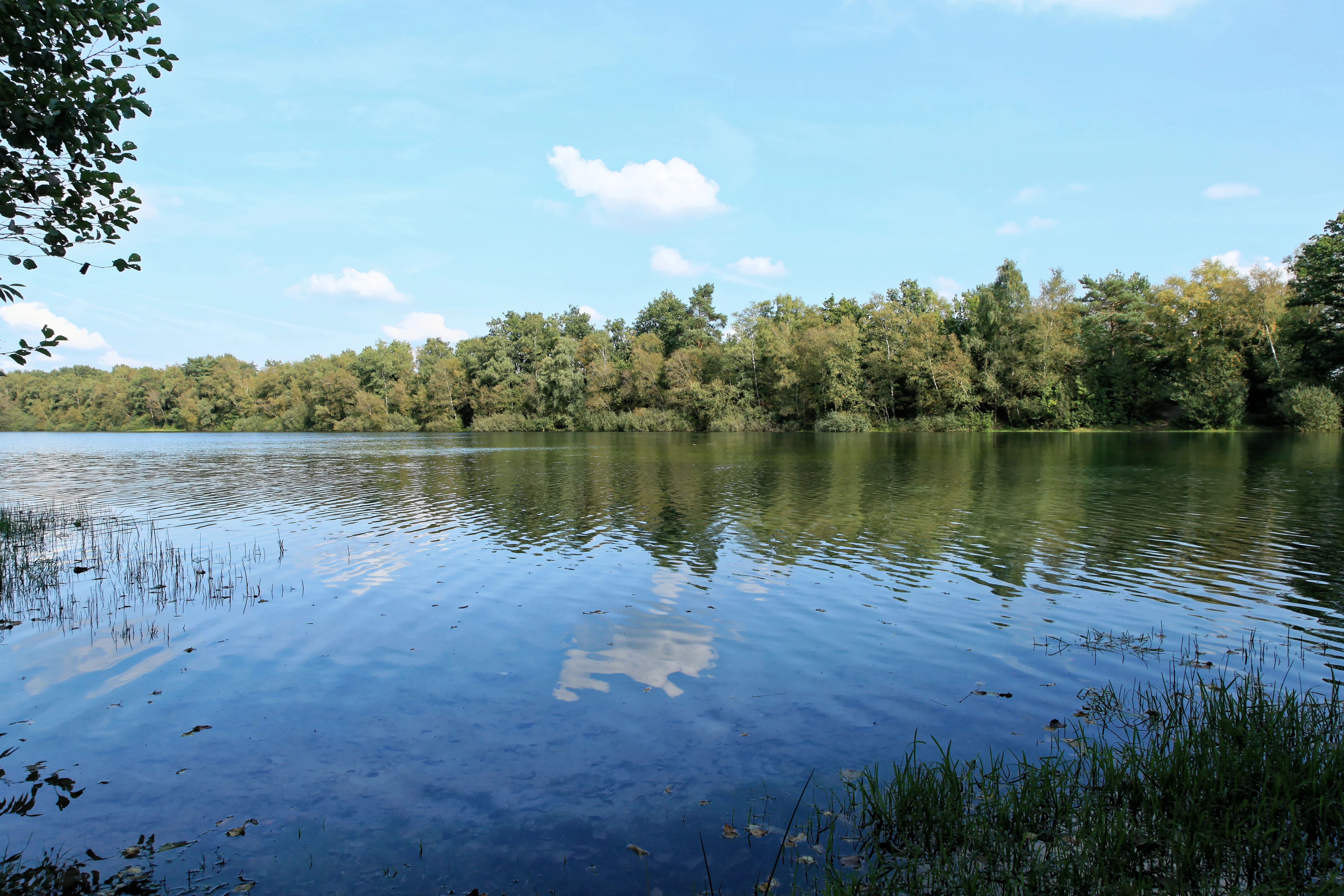
A calm, elongated body of water reflecting the blue sky and clouds, surrounded by dense green forest on the far bank with grassy vegetation in the foreground.
The tranquil waters of the former Gleesen-Papenburg side canal in the Stillgewässer bei Kluse nature reserve.

Stillgewässer bei Kluse history and protected-area timeline

The present-day reserve is a direct legacy of the unfinished Seitenkanal Gleesen-Papenburg, a planned canal whose halted construction left a series of elongated stillwater basins in the countryside northeast of Lathen. Over time, these abandoned channel sections evolved naturally into ecologically interesting standing waters with surrounding bog and woodland habitats.

Although the ecological features developed over decades, formal protection came relatively late. The area was officially designated as the Naturschutzgebiet Stillgewässer bei Kluse on 23 November 2018, with the identifier NSG WE 309. The protection order was issued under the responsibility of the Landkreis Emsland as the competent lower nature conservation authority.

Because the geographic boundaries of the nature reserve match exactly those of a same-named FFH site under the EU Habitats Directive, the designation also brought the area into the European Natura 2000 network. Since then, the site has been managed simultaneously as a national nature reserve and a Natura 2000 site, giving it both national and European-level habitat recognition.

Stillgewässer bei Kluse landscape and geographic character

Stillgewässer bei Kluse lies in the flat northwestern German lowlands, on the Emsland plain at elevations only a few meters above sea level. The terrain is gentle and essentially flat, with the reserve sitting between roughly 8 and 14 meters in elevation. There are no strong relief features; instead, the landscape character comes from the contrast between open water, bog margins, oak woodland on sand, and surrounding agricultural land.

The dominant landform element is a chain of long, narrow stillwater basins that follow the alignment of the never-completed Seitenkanal Gleesen-Papenburg. These elongated pools are fringed by gently sloping shore zones, floating bog mats in places, and patches of Eichenwald (oak forest) on drier sandy ground slightly set back from the water.

Surrounding the reserve, the landscape is almost entirely shaped by farming. Open arable fields and improved pasture extend right up to the protected area boundary in many places, and the reserve is framed by woods in some sections. Several public roads and farm tracks cut across the site, splitting it into the two non-contiguous parcels that define the protected area today.

Stillgewässer bei Kluse ecosystems, habitats, and plant life

The ecological identity of the reserve is built around a tight mosaic of aquatic, mire, and woodland habitats. The stillwater pools host Strandlings- and Zwergbinsengesellschaften, characteristic shore communities of Littorella and small rush species, with several regionally uncommon plants, including Flutende Moorbinse and Vielstängelige Sumpfbinse.

Along the northern parts of the area, the shoreline grades into transitional mires and Schwingrasenmoore (floating mat bogs). These soft, waterlogged surfaces are dominated by Schnabelried-Gesellschaften together with Sumpfstraußgras, Rasenbinse, and floating moor rush. The pools themselves support significant populations of Froschkraut, as well as Reinweißer Wasserhahnenfuß, Sumpf-Johanniskraut, and Pillenfarn, giving the open water and wet fringe a notably rich aquatic flora.

On slightly higher and drier ground, sandy soils support oak woodland composed of Stiel- and Traubeneiche. These Eichenwälder form a wooded buffer around parts of the reserve and connect the wetland core with the wider Emsland forest landscape. Together, water, mire margin, and dry oak edge create an unusually layered habitat structure for so small a protected area.

Stillgewässer bei Kluse wildlife and species highlights

Although compact, the reserve is important for several animal groups that benefit from the combination of open water, bog, and oak edge. It is documented habitat for birds, bats, amphibians, and dragonflies, with the open pools and their fringing vegetation providing breeding, feeding, and shelter conditions that are increasingly rare in the surrounding farmland.

Amphibians use the sheltered, fish-free stillwater pools as reliable breeding habitat, while dragonflies are supported by the mix of open water and floating bog vegetation. Bats likely use the oak woodland margins and the wooded edges around the pools for foraging and roosting. The broader bird community is enriched by the wetland and woodland mosaic in a district where such structures are otherwise limited.

Because the reserve is embedded in a strongly agricultural matrix, its wildlife value depends heavily on maintaining the contrast between the protected core and the surrounding fields. The standing waters and bog margins act as a small but important local refuge for wetland-dependent species in the Emsland lowlands.

Stillgewässer bei Kluse conservation status and protection priorities

Stillgewässer bei Kluse is significant for conservation because it preserves an unusually complete set of Natura 2000 habitat types in a very small area. The fact that it is simultaneously a Naturschutzgebiet and an FFH site means that its protection regime integrates strict national reserve rules with the obligations of the EU Habitats Directive, giving the site formal recognition at both regional and European levels.

The reserve conserves shore and dwarf rush communities, transitional mires, floating mat bogs, and oak woodland on sand, all in close proximity. In a district dominated by drained farmland, these habitats are scarce, and the reserve functions as a refuge for the specialist plant and animal species that depend on them.

Its conservation value is also tied to its origin. The stillwater basins are the unintended byproduct of halted canal construction, and protecting them prevents the loss of a habitat pattern that would be extremely difficult to recreate artificially in an intensively farmed landscape. Maintaining the two non-contiguous parcels under management of the Landkreis Emsland is therefore essential to keeping this small wetland-mire-woodland complex intact.

Top sights and standout views in Stillgewässer bei Kluse

The reserve's strongest distinction is its origin: a chain of ecologically mature stillwaters born from the unfinished Seitenkanal Gleesen-Papenburg. Around these pools, rare shore and dwarf rush communities, floating bogs, and sand-substrate oak woodland combine in a compact area of roughly 52 hectares, an unusually dense habitat mosaic for the Emsland plain.

Its designation as both a national nature reserve and a Natura 2000 FFH site gives it dual legal recognition, while the surrounding farmland makes the protected pools and bog margins function as a locally important refuge for amphibians, dragonflies, bats, and birds. The two-part structure of the area, crossed by roads and farm tracks, gives it a distinctive patchwork character unusual for a protected site of this scale.

Best time to visit Stillgewässer bei Kluse

The reserve is a working nature protection site in a low-lying agricultural landscape, and seasonal conditions shape what visitors can observe. Late spring and early summer are typically the most rewarding period for water-related habitats, when shore plant communities are in active growth, floating bog mats are most visible, and amphibian and dragonfly activity around the stillwater pools peaks.

Summer brings the fullest vegetation cover, when the contrast between the green wetland reserve and the surrounding cropland is at its sharpest. In autumn and winter, the oak woodland on sandy ground becomes more visually prominent as deciduous cover thins, and waterbird presence on the open pools can be easier to detect. Conditions at any season are shaped by the flat, low-elevation character of the Emsland plain, where weather can shift quickly across open farmland.

Monthly climate preview

Long-term representative temperature and precipitation patterns across the year

Stillgewässer bei Kluse Climate Normals and Annual Weather Rhythm

Representative coordinate records show measured average temperatures spanning from 1.52 °C to 17.89 °C alongside monthly precipitation rates between 1.38 mm and 2.49 mm per day. Examining the complete twelve-month climatology profile reveals detailed thermal ranges and multi-year environmental baselines.
Annual mean9 °C
2 °C18 °C
Jan
Feb
Mar
Apr
May13°
Jun16°
Jul18°
Aug18°
Sep14°
Oct10°
Nov
Dec
Warmest month
July

17.9 °C

Coolest month
January

1.5 °C

Wettest month
December

2.5 mm/day

Driest month
April

1.4 mm/day

Park location guide

Geography guide, regional context, and park location map for Stillgewässer bei Kluse

Stillgewässer bei Kluse park geography, regions, and map view in Germany

Understand where Stillgewässer bei Kluse sits in Germany through a broader geographic reading of the surrounding landscape, nearby location context, and its mapped position within the national park landscape.

How Stillgewässer bei Kluse fits into Germany

Germany is a federal republic in Western and Central Europe with a population of over 83 million across sixteen constituent states. It is Europe's largest economy by nominal GDP and a major global exporter and importer. The capital is Berlin, and the country borders Denmark, Poland, Czech Republic, Austria, Switzerland, France, Luxembourg, Belgium, and the Netherlands.

Wider geography shaping Stillgewässer bei Kluse in Germany

Germany is located in Western and Central Europe, spanning 357,022 km². It borders Denmark to the north, Poland and the Czech Republic to the east, Austria and Switzerland to the south, and France, Luxembourg, Belgium, and the Netherlands to the west. The country has coastlines on the Baltic Sea and North Sea to the north, with the Alps located in the southern region.

Map view of Stillgewässer bei Kluse

Use this park location map to pinpoint Stillgewässer bei Kluse in Germany, understand its exact geographic position, and read its mapped placement within the surrounding landscape more clearly.

Pigeon | © OpenStreetMap contributors

Location context for Stillgewässer bei Kluse

Landkreis Emsland

Visual exploration of wetland habitats, bog margins, and sandy oak woodland terrain

Stillgewässer bei Kluse Photos and Landscape Scenery: Protected Area Imagery

Photographic collections reveal the unique wetland scenery and specialized aquatic habitats preserved within the protected area. Examining visual records helps researchers understand the terrain, shoreline communities, and ecological character of the Emsland lowland landscape.

A calm, elongated body of water reflecting the blue sky and clouds, surrounded by dense green forest on the far bank with grassy vegetation in the foreground.

Park atlas

Compare adjacent wetland habitats and surrounding lowland nature reserves in the Emsland plain.

Parks Near Stillgewässer bei Kluse and Regional Protected Landscapes

Browsing protected areas near Stillgewässer bei Kluse reveals similar lowland wetland habitats and rare aquatic ecosystems across the Emsland district. Continuing into adjacent regional parks provides broader geographic context for comparing man-made water bodies and sandy oak woodlands.
Nature reserveLower Saxony
About 9.6 km away#1 closest

East

Windelberg Nature Reserve: Protected Inland Dune and Heathland Mosaic in Lower Saxony

Historic sandy heath and oak woodland conservation site

Windelberg is a significant nature reserve in the Emsland region, featuring inland dunes and juniper heathland on the Hümmling glacial ridge. This area showcases a compact mosaic of dry, acidic habitats and relict oak woodland that reflects centuries of traditional land management in northwest Germany. Its status as a protected area within the Natura 2000 network highlights its importance for regional habitat conservation.

Area
0.163 km²
Established
2009
IUCN
IV
Nature reserveLower Saxony
About 16 km away#2 closest

Southwest

Tausendschrittmoor Nature Reserve: Peatland Recovery and Raised Bog Geography in Emsland

A study in protected lowland peatland landscapes and recovery trajectories

Tausendschrittmoor serves as a vital nature reserve in Lower Saxony, protecting a rare pocket of raised bog habitat amidst an agricultural landscape. The reserve features two contrasting habitats: a rewetted western bog and an eastern bog woodland, each illustrating unique patterns of peatland regeneration on the North German Plain.

Area
0.655 km²
Established
1988
Protected landscapeEmsland
About 17 km away#3 closest

Southeast

Naturpark Hümmling: Geographic Overview of Emsland Protected Landscapes

Tracing glacial sand ridges, moorlands, and prehistoric cultural sites.

Naturpark Hümmling stands as a prominent protected landscape in Lower Saxony, characterized by its distinctive geest ridge, extensive raised bogs, and dense concentration of Neolithic stone monuments. The area map highlights a complex interplay of river valleys, heathland remnants, and historic cultural landmarks that define the geographical identity of this Emsland treasure.

Area
576 km²
Established
2015
Relief
Upland
Climate
Temperate
Nature reserveLower Saxony
About 21 km away#4 closest

South

Südtannenmoor Nature Reserve in Lower Saxony: An Atlas of Protected Bog Wetlands

Mapping rare heath pool ecosystems in the Emsland region

This nature reserve protects a fragile intersection of raised-bog remnants and shallow heath pools framed by coniferous forests. The site serves as a key reference for the restoration of specialized wetland vegetation in northwestern Germany, offering a clear view of how small-scale geography influences biodiversity in the Emsland landscape.

Area
0.049 km²
Established
2009
IUCN
IV
Relief
Lowland
Nature reserveLandkreis Leer
About 21 km away#5 closest

North

Vellage Nature Reserve: Protected Wetland and Ems Floodplain Geography in Landkreis Leer

A study of floodplain terrain, wetland habitats, and dike-protected ecosystems.

Vellage is a significant nature reserve in the district of Leer, characterized by its cluster of inland freshwater ponds and deadwood-rich alder woodlands. Located within the Ems floodplain landscape, the reserve functions as a critical habitat mosaic for native amphibians and aquatic species, providing a clear example of protected lowland river geography in Lower Saxony.

Area
0.084 km²
Established
2018
Nature reserveEmsland
About 25 km away#6 closest

Southwest

Versener Heidesee Nature Reserve: Mapped Protected Areas in Emsland, Lower Saxony

Heathland habitats and aquatic ecosystems in the Bourtanger Moor region

Versener Heidesee represents a significant example of post-industrial landscape reclamation, where a motorway extraction site was transformed into a protected nature reserve. The site spans 40 hectares, featuring a 16-hectare lake and managed heathland that sustains rare algae species and diverse avian populations. Its location within the International Nature Park Bourtanger Moor-Bargerveen highlights the importance of small-scale, managed terrain for regional ecological health.

Area
0.4 km²
Established
2008
Relief
Lowland
Climate
Temperate
Nature reserveLower Saxony
About 26 km away#7 closest

Southwest

Wesuweer Moor Protected Area: A Geographic Overview of Lower Saxony Peatland Landscapes

Raised bog conservation, moor heath, and wetland restoration in Emsland

Wesuweer Moor represents a critical protected landscape in northwestern Germany. This nature reserve serves as a focal point for understanding the geography of raised bogs, documenting the impact of rewetting efforts on former peat-harvesting sites. The area provides essential context for regional moorland ecology, illustrating the distribution of bog woodland, moor heath, and managed drainage systems across the Emsland plains.

Area
4.09 km²
Established
2008
IUCN
IV
Relief
Lowland
Nature reserveEmsland
About 27 km away#8 closest

Southwest

Südliches Versener Moor Nature Reserve: Emsland Peatland Geography and Protected Landscape

A restored raised bog within the International Nature Park Bourtanger Moor-Bargerveen

Located in Emsland, Südliches Versener Moor is a protected nature reserve defined by its history of peat extraction and ongoing rewetting efforts. The area is part of the larger Bourtanger Moor complex, featuring rare remnants of intact raised bog terrain alongside restored peatland zones that highlight regional conservation dynamics in northwestern Germany.

Area
1 km²
Established
1999
IUCN
IV

Common questions about visiting, size, designation, and location context for Stillgewässer bei Kluse

Stillgewässer bei Kluse FAQs for park facts, access, geography, and protected area context

Find quick answers about Stillgewässer bei Kluse, including protected-area facts, park geography, trail and visitor context, and how the park fits into its surrounding country and regional landscape.
MoriAtlas Explorer

Continue Your Protected Areas Search Across the Global Atlas

Deepen your exploration by continuing the structured search for national parks and protected areas worldwide. Utilize the comprehensive filtering capabilities to compare different conservation landscapes and refine your understanding of global park geography. Discover more about the distribution and characteristics of protected natural areas.

Global natural geography