
Mori Atlas logo
Nature reserveStreitmoor

A compact example of terrestrialization moor geography featuring layered wetland to forest transitions

Streitmoor Nature Reserve and Mapped Protected Landscape in the Ilmenau Lowlands of Lower Saxony

(Naturschutzgebiet Streitmoor)

Streitmoor represents a distinct protected nature reserve situated on the edge of the Ilmenau river lowlands in Lower Saxony. This compact fifteen hectare site serves as a textbook example of a terrestrialization moor, where former pond environments have developed into specialized habitats. The geography transitions through a clear gradient of reedbeds and peat moss into birch woodland and dry pine forest, illustrating complex bog succession within a small, sensitive ground depression.

bogmoorpeat mossreedbedbirch woodlandpine forest
A graphic illustration showing a forest of white birch trees in the foreground with a waterfall and cliffs in the background.

Streitmoor

Nature reserve

Park overview

Structured park overview, official facts, and landscape profile for Streitmoor

Streitmoor park facts, protected area profile, and essential visitor context

Review the core facts for Streitmoor, including designation, size, terrain, visitor scale, habitats, and operating context in one park-focused overview.

About Streitmoor

Streitmoor is a compact nature reserve located at the northern edge of the city of Lüneburg in Lower Saxony, Germany, extending slightly into the neighboring municipality of Adendorf. Despite its small footprint, it carries real ecological significance because it preserves an entire sequence of bog-forest habitats within a single protected area.

The reserve occupies an elongated ground depression lying parallel to the edge of the Ilmenau lowlands. A low ridge separates it from the active floodplain of the Ilmenau river, so the site sits just above the lowest parts of the surrounding terrain while still holding enough water to support genuine wetland communities. This mild topographic setting has allowed the formation of a classic terrestrialization moor, where a former standing body of water has gradually filled in and been overgrown by successive wetland and woodland vegetation.

To the north and west, Streitmoor connects to the broader landscape protection area of the Lüneburg district, embedding the small strict reserve inside a wider matrix of managed countryside. The site was formally protected in 1972 under the designation NSG LÜ 020 and is administered by the Lüneburg district under the umbrella of the Lower Saxony Agency for Water Management, Coastal Defense and Nature Conservation (NLWKN). Because the reserve is drained toward the Ilmenau by a ditch and is ecologically delicate, public access to the area is restricted, and the reserve is understood primarily as a conservation refuge rather than a recreational site.

Within the cluster of small nature reserves that dot the Lüneburg district along with sites such as Bültenmoor, Dieksbeck, Fehlingsbleck, and the Lüneburger Ilmenauniederung, Streitmoor represents a particularly clear example of how a very small area can conserve a complete gradient from open water-edge vegetation through bog communities into upland forest.

Quick facts and research context for Streitmoor

Streitmoor is a designated nature reserve (Naturschutzgebiet) in Lower Saxony, Germany, located north of Lüneburg and west of Adendorf in the Lüneburg district. It sits on the edge of the Ilmenau lowlands, separated from the river floodplain by a low ridge, and covers approximately 13 hectares at an elevation of roughly 9 to 12 meters.

Established as a protected area on 7 June 1972, the reserve is catalogued under the identifier NSG LÜ 020 and has a World Database on Protected Areas (WDPA) entry of 82656. It is classified as an IUCN Category IV Habitat/Species Management Area, with the responsibility for its administration shared between the Lüneburg district and the Lower Saxony Agency for Water Management, Coastal Defense and Nature Conservation (NLWKN).

Protection and recognition

Explore terrestrial protection records, management scope, and verified designation data.

Streitmoor Protection Status and Documented Conservation Framework

Streitmoor maintains a recorded terrestrial protection framework detailing official designation records and management scope. Conservation researchers examine these verified database entries to trace international recognition metrics and administrative boundaries.

Protection details

Protection scope
Terrestrial
Transboundary protection
No
WDPA ID
82656
Park context

Deeper park guide and search-rich context for Streitmoor

Streitmoor history, landscape, wildlife, and travel context

Explore Streitmoor through its history, landscape character, ecosystems, wildlife, conservation priorities, cultural context, and seasonal travel timing in a structured park guide built for atlas discovery and search intent.

Why Streitmoor stands out

Streitmoor is best known for being a compact, well-documented example of a terrestrialized pond moor (Verlandungsmoor) embedded in the cultural landscape of the Ilmenau lowlands. Its wet center of reedbeds and peat moss transitions outward through cottongrass and birch woodland into pine forest on the drier margins, producing a textbook cross-section of small-scale bog succession within a single small reserve. It is also notable as part of the dense network of small nature reserves that characterizes the Lüneburg district, where former ponds, low ridges, and drained lowlands have produced many small, highly specialized protected sites. Within this network, Streitmoor stands out for the clarity of its classic Verlandungsmoor structure and for the intact transition between open wetland, bog woodland, and dry pine forest.
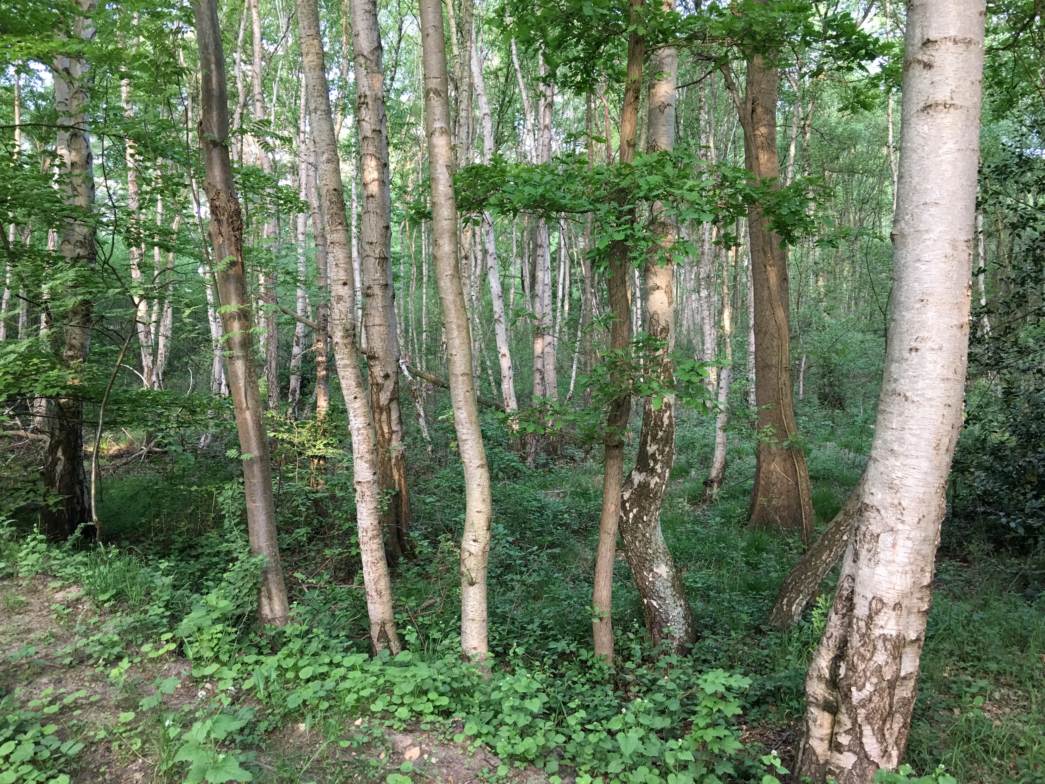
View into a dense forest with tall, slender birch trees showing light-colored trunks; the ground is covered in green shrubs and vegetation.
A stand of birch trees within the Streitmoor nature reserve, characterized by a lush, green understory.

Streitmoor history and protected-area timeline

Streitmoor originated as a natural feature of the landscape rather than as a planned conservation project: it formed in a ground depression where a former pond was gradually overgrown by vegetation, producing the classic terrestrialization moor sequence (Verlandungsmoor) that the reserve protects today. For a long period the surrounding land was shaped by agriculture, drainage, and forestry typical of the Lüneburg district, and the Ilmenau lowlands in particular were heavily modified for floodplain use.

Formal recognition of the site as a nature reserve (Naturschutzgebiet) came on 7 June 1972, when it was placed under the protection of the then-current Lower Saxon nature conservation framework under the designation NSG LÜ 020. The reserve boundary to the north and west abuts the landscape protection area of the Lüneburg district, integrating Streitmoor into a broader network of protected countryside rather than treating it as an isolated patch. Since its designation, responsibility for managing and overseeing the reserve has rested with the Lüneburg district as the lower nature conservation authority (untere Naturschutzbehörde), with the Lower Saxony Agency for Water Management, Coastal Defense and Nature Conservation (NLWKN) serving as the higher-level technical authority. The reserve's profile is also recorded internationally through the World Database on Protected Areas entry 82656.

Streitmoor landscape and geographic character

The Streitmoor landscape is defined by its subtle but precise topography. The reserve sits within an elongated, shallow ground depression that runs broadly parallel to the Ilmenau lowlands, from which it is separated by a low ridge. Elevation across the site is very modest, ranging only from about 9 to 12 meters above sea level, yet these few meters of relief are enough to create a clear gradient from a wet central basin to much drier margins.

In its inner, lowest sections, the landscape carries a strongly wetland character, marked by reedbeds and peat-forming mosses that reflect the long history of silting-up of the original pond. Moving outward and slightly upward, the wetness decreases and the vegetation shifts into a transitional belt dominated by cottongrass and birch woodland, giving way finally to pine forest on the higher, drier ground at the edges of the depression. The result is a compact, layered landscape in which open bog, bog woodland, and dry conifer forest all coexist within a few hundred meters of one another.

A drainage ditch connects the basin to the Ilmenau, moderating the water table and keeping the bog at a relatively stable, though still ecologically sensitive, level. This human-engineered element is part of why the reserve is also understood as a semi-natural landscape rather than a purely untouched ecosystem.

Streitmoor ecosystems, habitats, and plant life

Streitmoor protects a small but unusually complete sequence of bog habitats that reflect the classic process of terrestrialization. At the ecological center of the reserve lies a Verlandungsmoor, a moor that developed as a former pond filled in over time. Reed communities (Schilfröhrichte) occupy the wettest zones of the basin, where water levels remain highest and nutrient cycling is dominated by emergent vegetation.

Around the reed fringe, peat mosses (Sphagnum and related genera) take over as the principal peat formers, building up the characteristic spongy, waterlogged substrate of an active bog. Beyond the moss zone, the moisture conditions become more variable, and the vegetation transitions into communities dominated by cottongrass (Pfeifengräser) and scattered birch trees, producing the mosaic commonly described as birch bog woodland.

Further out on the slightly higher, better-drained ground, the bog character yields to dryland forest dominated by pine (Kiefer), with birch still present as a subordinate component. This transition from reed to peat moss to cottongrass-birch to pine forest within a single small area gives Streitmoor its particular ecological value: despite its size, it preserves a textbook cross-section of northern German bog-forest succession.

Streitmoor wildlife and species highlights

The wildlife profile of Streitmoor is shaped above all by the habitat mosaic of reedbeds, peat moss communities, birch bog woodland, and pine forest. The wetland core provides cover and foraging habitat for reed-bed birds and amphibians typical of small lowland bogs in Lower Saxony, while the birch and pine fringes offer resources for woodland bird species and small mammals associated with young, moist forest.

Because the reserve is closed to public access to prevent disturbance to the delicate bog surface and because of its small size, the area is not known as a site for large charismatic mammals. Its biological interest lies more in the plant communities and the invertebrate and small-vertebrate assemblages associated with them, particularly those tied to reedbeds and Sphagnum-dominated peat. Standing water and saturated peat also support characteristic amphibian and dragonfly communities typical of comparable Verlandungsmoore in the region.

Streitmoor conservation status and protection priorities

Conservation importance at Streitmoor is tied primarily to the protection of a small but ecologically complete terrestrialization moor within a heavily cultivated landscape. The reserve safeguards the full transition from open reeds through active peat-forming moss communities into birch bog woodland and finally into drier pine forest, preserving a sequence that has become rare in intensively used lowlands.

The site also functions as part of a broader conservation network: it is adjacent to the landscape protection area of the Lüneburg district, which buffers the strict reserve and links it to other protected countryside. Internationally, Streitmoor is classified as an IUCN Category IV Habitat/Species Management Area and is registered in the World Database on Protected Areas under ID 82656, reflecting its formally recognized role in habitat and species management at a regional scale.

Management is overseen by the Lüneburg district as the lower nature conservation authority, with technical guidance from the NLWKN. A drainage ditch carries water from the basin toward the Ilmenau, and to protect the fragile bog surface and hydrology, public access to the reserve is not permitted.

Streitmoor cultural meaning and human context

Streitmoor sits within the historic cultural landscape of the Lüneburg district, an area shaped for centuries by agriculture, peat cutting, and forestry, and dominated by the city of Lüneburg and the Ilmenau river system. Although the reserve itself is a strictly protected ecological refuge, its existence is closely tied to the surrounding land: the ridge that separates it from the Ilmenau lowlands and the drainage ditch that links it back to the river are both products of long human management of this terrain.

Locally, Streitmoor is one of many small nature reserves that together form the identity of the Lüneburg district as a region of high ecological density, where modest, tightly protected sites are embedded in a broader matrix of farmland, settlement, and riverside land. The reserve's role is therefore both ecological and cultural: it preserves a piece of the region's natural heritage while reinforcing the area's longstanding self-image as a landscape where nature protection and everyday land use coexist.

Top sights and standout views in Streitmoor

A textbook example of a terrestrialization moor (Verlandungsmoor), compact enough to see in a single visit but complete enough to illustrate the full wetland-to-forest gradient. Within a few hundred meters, reeds, peat mosses, cottongrass, birch woodland, and pine forest form a clear ecological sequence that is increasingly rare in modified lowlands. The reserve's adjacency to the Lüneburg district landscape protection area links the strict reserve to a wider conservation fabric, and its long-standing designation since 1972 and inclusion in the World Database on Protected Areas underline its formal recognition.

Best time to visit Streitmoor

Because Streitmoor is a strict nature reserve that is not open to public access and is ecologically sensitive, it is not a destination for casual visits, and any visit planning should focus on surrounding paths and landscape-scale viewing rather than entry into the site. From a broader landscape perspective, the Ilmenau lowlands near Lüneburg are most visually expressive in late spring and summer, when reedbeds and cottongrass are in active growth, and in early autumn when shifting light brings out the contrast between bog and pine forest.

For birdwatchers and naturalists interested in the surrounding landscape rather than the reserve itself, late spring to early summer tends to be the richest season in the region, while winters can highlight the structure of the birch and pine stands against the bare deciduous trees. Any approach to the reserve boundary should respect the no-entry rule and avoid disturbance to the bog surface and drainage system.


Monthly climate preview

Review long term weather by month records and representative coordinate observations for Streitmoor

Streitmoor Climate Normals and Measured Annual Temperature and Precipitation Patterns

Representative coordinate measurements record sustained annual temperature shifts and monthly precipitation rhythms across Streitmoor. Detailed twelve month climate statistics provide a thorough breakdown of long term meteorological averages for comparative geographical analysis.
Annual mean9 °C
0 °C18 °C
Jan
Feb
Mar
Apr
May13°
Jun16°
Jul18°
Aug18°
Sep14°
Oct
Nov
Dec
Warmest month
July

18.1 °C

Coolest month
January

0.3 °C

Wettest month
July

2.5 mm/day

Driest month
April

1.4 mm/day

Park location guide

Geography guide, regional context, and park location map for Streitmoor

Streitmoor park geography, regions, and map view in Germany

Understand where Streitmoor sits in Germany through a broader geographic reading of the surrounding landscape, nearby location context, and its mapped position within the national park landscape.

How Streitmoor fits into Germany

Germany is a federal republic in Western and Central Europe with a population of over 83 million across sixteen constituent states. It is Europe's largest economy by nominal GDP and a major global exporter and importer. The capital is Berlin, and the country borders Denmark, Poland, Czech Republic, Austria, Switzerland, France, Luxembourg, Belgium, and the Netherlands.

Wider geography shaping Streitmoor in Germany

Germany is located in Western and Central Europe, spanning 357,022 km². It borders Denmark to the north, Poland and the Czech Republic to the east, Austria and Switzerland to the south, and France, Luxembourg, Belgium, and the Netherlands to the west. The country has coastlines on the Baltic Sea and North Sea to the north, with the Alps located in the southern region.

Map view of Streitmoor

Use this park location map to pinpoint Streitmoor in Germany, understand its exact geographic position, and read its mapped placement within the surrounding landscape more clearly.

Pigeon | © OpenStreetMap contributors

Location context for Streitmoor

Lower Saxony

Explore detailed visual records of terrain transitions and wetland vegetation zones.

Streitmoor Photos and Landscape Scenery: Visualizing Protected Bog Habitats

Visual documentation reveals the layered transition from wet central reedbeds to dry pine forest across the protected nature reserve. Examining these landscape photographs clarifies the distinct ecological zones and subtle topography shaping the protected basin.

View into a dense forest with tall, slender birch trees showing light-colored trunks; the ground is covered in green shrubs and vegetation.

Park atlas

Compare nearby nature reserves and regional wetland geography across Lower Saxony

Exploring Other Parks Near Streitmoor and Surrounding Protected Landscapes

Continue geographic discovery by comparing Streitmoor with other protected areas and wetland reserves across the surrounding Lüneburg district. Examining adjacent natural habitats provides broader context for regional bog succession and lowland conservation networks.
Nature reserveLower Saxony
About 9.2 km away#1 closest

West

Wittsaal Nature Reserve: Mapped Wetland Geography and Protected Landscape in Lower Saxony

A rare mosaic of moor ponds and swamp woodland

Wittsaal is a specialized nature reserve in the Lüneburg region of Lower Saxony, Germany. The area protects a peat-cut moor pond currently undergoing natural silting, surrounded by willow-dominated swamp woodland, reedbeds, and sedge marshes. This compact site provides a critical, quiet refuge for wetland ecology within a wider landscape of agricultural fields and transitional glacial terrain.

Area
0.13 km²
Established
1985
IUCN
IV
Relief
Lowland
Nature reserveUelzen District
About 15 km away#2 closest

South

Vierenbach Nature Reserve: Landscape Geography and Protected Area Mapping in Uelzen District

A study of lowland stream valleys and swamp forest ecosystems.

Vierenbach serves as a crucial lowland stream sanctuary in the Uelzen District, featuring a concentrated variety of alder and ash swamp forests, birch bog woodlands, and wet fen grasslands. This entry offers a deep look into the reserve's unique transition zones between waterlogged valley floors and drier oak-hornbeam Geest slopes.

Area
2.3 km²
Established
2004
IUCN
IV
Nature reserveHamburg
About 20 km away#3 closest

Northwest

Zollenspieker Nature Reserve: Geographic Overview and Protected Riverine Landscapes

Tidal Elbe floodplain and inland brack wetland ecology

Located in the Hamburg borough of Bergedorf, Zollenspieker protects a significant stretch of the tidal Elbe. This nature reserve contains approximately 80 hectares of diverse terrain, from freshwater mudflats exposed at low tide to sheltered oak-dominated forests and old brack wetlands known as Carlsbrack and Riepenburger Brack.

Area
0.8 km²
Established
1988
IUCN
IV
Relief
Lowland
Nature reserveLandkreis Uelzen
About 25 km away#4 closest

South

Wettenbosteler Moor Protected Area: Geographic Overview and Mapped Landscape Features

A resilient raised bog remnant in the Landkreis Uelzen heath forest

Spanning roughly thirteen hectares, Wettenbosteler Moor preserves a rare spring-fed bog habitat characterized by peat-forming vegetation and pine forest borders. This nature reserve offers deep insights into the drainage networks and lowland terrain of the Lüneburg Heath, mapping the transition between upland forest and valley mire.

Area
0.128 km²
Established
1977
IUCN
IV
Relief
Lowland
Nature reserveLower Saxony
About 25 km away#5 closest

Northwest

Stemmbruch Nature Reserve: Protected Lowland Bog Geography in Lower Saxony, Germany

A resilient moorland habitat near the Seeve floodplain

Stemmbruch serves as a vital nature reserve in the Harburg district, protecting a rare hanging spring bog system. This compact protected area features a mosaic of bog pools, heath, and swamp woodland, demonstrating the complex hydrologic connectivity between the sandy geest ridge and the surrounding northern German lowland plains.

Area
0.56 km²
Established
1989
IUCN
IV
Relief
Lowland
Nature reserveLandkreis Uelzen
About 30 km away#6 closest

Southeast

Vogelfreistätte Jastorfer See Nature Reserve in Landkreis Uelzen, Germany

Wetland habitat and river valley protected area

Vogelfreistätte Jastorfer See is a protected wetland landscape located in the Ilmenau valley. This nature reserve, spanning 16.5 hectares, preserves a mosaic of open water and alder swamp forest that sustains diverse bird populations including kingfishers and marsh harriers. It serves as a regionally significant conservation site, embedded within the broader Ilmenautal protected corridor in northern Germany.

Area
0.165 km²
Established
1977
IUCN
IV
Relief
Lowland
A horizontal watercolor painting depicting a rolling heathland landscape with purple heather, evergreen trees, and a central water feature under a soft sky.
Protected landscapeLower Saxony
About 34 km away#7 closest

West

Naturpark Lüneburger Heide: Protected Landscape Map and Regional Geography

An expansive cultural landscape in northern Lower Saxony

Spanning over 1,000 square kilometers, Naturpark Lüneburger Heide preserves the largest contiguous inland heathlands in Central Europe. Use this atlas resource to understand the park's glacial terrain, including karst sinkholes and natural springs, as well as its status as a model region for sustainable conservation and traditional land management practices.

Area
1,097.85 km²
Established
1922
IUCN
V
Relief
Lowland
A watercolor painting showing a panoramic view of a calm river with a small, vegetated island in the center and pink wildflowers in the foreground.
Nature reserveHamburg
About 34 km away#8 closest

Northwest

Schweenssand Nature Reserve: Protected Elbe Floodplain Geography in Hamburg Germany

Tidal freshwater wetlands, reedbeds, and riverine forest mosaics

Spanning 35 hectares along the Süderelbe, Schweenssand acts as a vital protected area within the Hamburg city boundary. Its geography consists of freshwater tidal flats, mudflats, and ancient-looking floodplain forests that are continuously shaped by the Elbe river tide. This site offers a clear view into the ecological complexity of urban-fringe river landscapes and European Natura 2000 protected zones.

Area
0.4 km²
Established
1993
IUCN
IV
Relief
Lowland

Common questions about visiting, size, designation, and location context for Streitmoor

Streitmoor FAQs for park facts, access, geography, and protected area context

Find quick answers about Streitmoor, including protected-area facts, park geography, trail and visitor context, and how the park fits into its surrounding country and regional landscape.
MoriAtlas Explorer

Continue Your Protected Areas Search Across the Global Atlas

Deepen your exploration by continuing the structured search for national parks and protected areas worldwide. Utilize the comprehensive filtering capabilities to compare different conservation landscapes and refine your understanding of global park geography. Discover more about the distribution and characteristics of protected natural areas.

Global natural geography