
Mori Atlas logo
Nature reserveStuckenstein-Eichen

A study of forest succession and preserved cultural landscapes within the Solling hill range

Stuckenstein-Eichen Nature Reserve: Mapping Historic Oak Pasture Woodlands in Lower Saxony

(Naturschutzgebiet Stuckenstein-Eichen)

Stuckenstein-Eichen represents a unique nature reserve in Lower Saxony, Germany, where historical land use and natural forest dynamics converge. The site protects twenty hectares of forest, featuring a rare Hutewald oak pasture woodland in its southern portion and a naturally evolving Hainsimsen beech forest in the north. This protected area offers a clear look at how veteran trees, deadwood habitats, and intentional conservation management shape regional geography.

oak woodlandbeech forestHutewaldwood pasturedeadwood habitatveteran trees
A stylized flat vector illustration of a forest with tall green trees and a fallen log in the foreground; a waterfall cascades down a rocky cliff in the middle distance under a pale sun.

Stuckenstein-Eichen

Nature reserve

Park overview

Structured park overview, official facts, and landscape profile for Stuckenstein-Eichen

Stuckenstein-Eichen park facts, protected area profile, and essential visitor context

Review the core facts for Stuckenstein-Eichen, including designation, size, terrain, visitor scale, habitats, and operating context in one park-focused overview.

About Stuckenstein-Eichen

Stuckenstein-Eichen is a compact but ecologically and culturally distinctive nature reserve in the northwestern Solling, a forested low mountain range in southern Lower Saxony. The site lies within the larger Solling-Vogler Nature Park, which frames the broader landscape of mixed forests, valleys, and traditional land uses in the Weser region.

The reserve protects roughly 20 hectares of forest that reflects two different historical trajectories. The southern part preserves an old oak pasture woodland, or Hutewald, where trees were originally planted in a regular pattern to provide shade and mast for grazing livestock. After this traditional use ended, the site has been actively managed to keep the wood-pasture character readable in the landscape: beech trees invading the area are removed, allowing the original layout of large, veteran oaks to remain visible. The high proportion of old trees and standing or fallen deadwood gives this section strong habitat value for fungi, lichens, and insects associated with decaying wood.

The northern part of the reserve follows a very different story. After forestry was abandoned there in the first half of the twentieth century, the forest has been left to develop naturally into a Hainsimsen beech wood (Luzulo-Fagenion), a community typical of more acidic, moderately nutrient-poor soils in central European uplands. Today this section is allowed to evolve without active intervention, providing a living contrast within the same reserve between a culturally maintained past and a naturally unfolding future.

Together, the two halves of Stuckenstein-Eichen make the site a small but instructive example of how small German nature reserves can combine heritage landscape preservation with ecological process protection, all on a scale easily explored on foot from Holzminden.

Quick facts and research context for Stuckenstein-Eichen

Stuckenstein-Eichen is a designated Naturschutzgebiet in Lower Saxony, bearing the official code NSG HA 131. It covers approximately 20 hectares and has been protected since 19 May 1988, with the district of Holzminden serving as the responsible lower nature conservation authority. The site is administered under the oversight of the Lower Saxony State Office for Water Management, Coastal Protection and Nature Conservation (NLWKN) and is classified as an IUCN Category IV Habitat/Species Management Area. It sits within the Solling-Vogler Nature Park, between roughly 253 and 298 meters in elevation.

Protection and recognition

Examine the terrestrial protection scope and documented conservation records.

Stuckenstein-Eichen Protection Status and International Recognition Data

Stuckenstein-Eichen maintains a documented terrestrial protection status within the global protected area registry. Formal records aggregate management scope and administrative designation details for systematic analysis.

Protection details

Protection scope
Terrestrial
Transboundary protection
No
WDPA ID
165775
Park context

Deeper park guide and search-rich context for Stuckenstein-Eichen

Stuckenstein-Eichen history, landscape, wildlife, and travel context

Explore Stuckenstein-Eichen through its history, landscape character, ecosystems, wildlife, conservation priorities, cultural context, and seasonal travel timing in a structured park guide built for atlas discovery and search intent.

Why Stuckenstein-Eichen stands out

Stuckenstein-Eichen is best known for its well-preserved Hutewald character, an old oak pasture woodland where the original planting pattern of historic oaks can still be traced in the landscape. The reserve combines this culturally shaped forest type with a high volume of old trees and deadwood, making it a notable example of how traditional land use and natural forest succession coexist within a single protected site. The reserve also illustrates an active conservation management approach: in the southern section, natural regeneration toward beech forest is intentionally suppressed through targeted removal of beech so the wood-pasture layout remains visible, while the northern section is deliberately allowed to develop as Hainsimsen beech woodland without intervention.
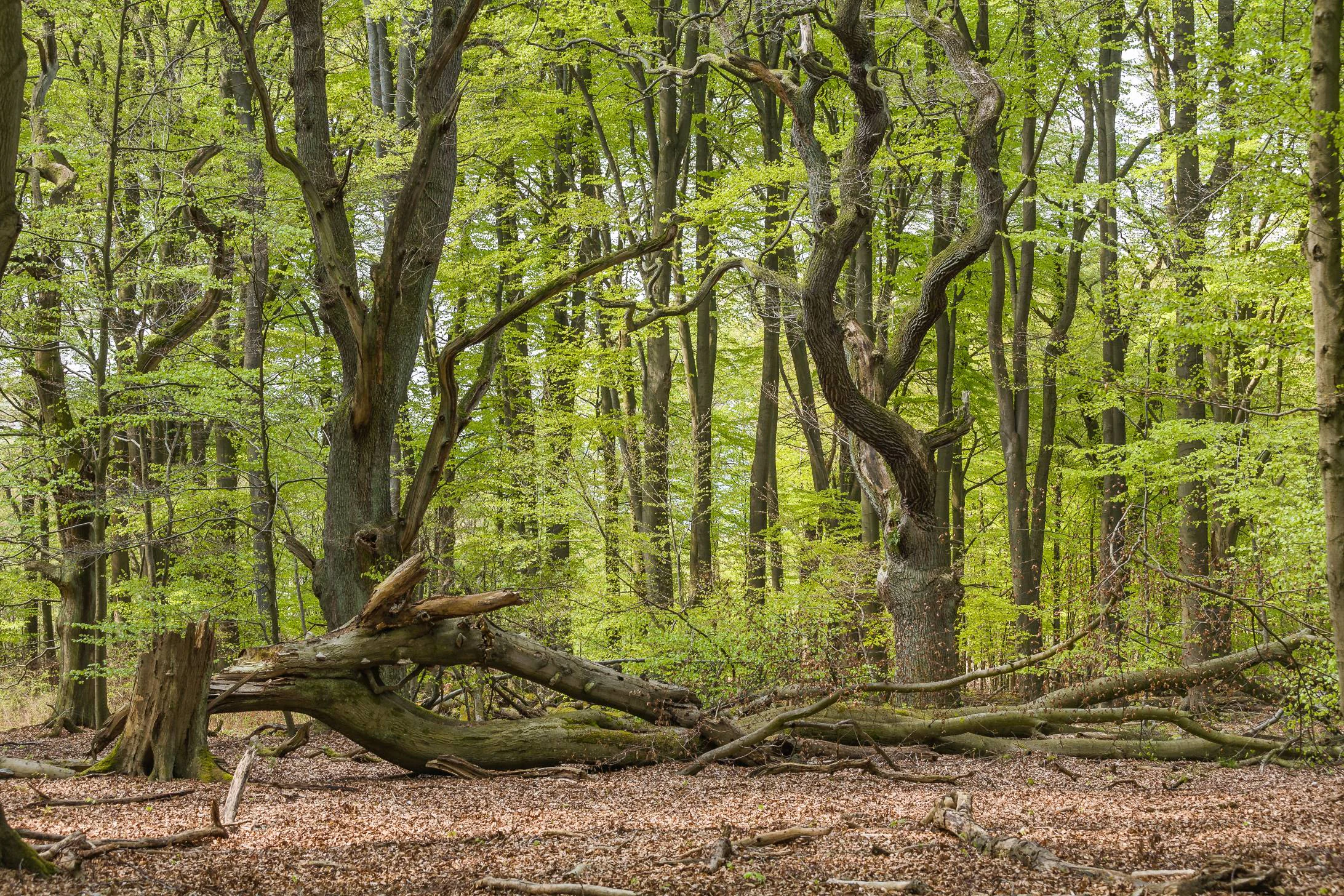
A woodland scene in spring with light green foliage on mature trees and a large, fallen mossy tree trunk resting on the forest floor.
A dense forest interior featuring ancient trees and a fallen log in the Stuckenstein-Eichen nature reserve.

Stuckenstein-Eichen history and protected-area timeline

The forest landscape at Stuckenstein-Eichen reflects centuries of human shaping, even though the reserve itself is a much more recent institution. In the southern part of the area, the land was once managed as a Hutewald, or wood pasture, in which oaks were planted in a regular pattern and used in combination with grazing livestock. This historical planting grid is still legible today and forms one of the reserve's defining features.

When the wood-pasture tradition ended, the natural ecological tendency of the site would have been to develop into Hainsimsen beech forest. To prevent this loss of cultural character, active management was introduced to remove invading beech and keep the oak pasture structure recognizable.

The northern part of the reserve was used for forestry until the first half of the twentieth century, after which it was abandoned. Since that time it has been left to develop naturally into beech forest, embodying a deliberately hands-off approach to conservation.

The area received formal protection as the Naturschutzgebiet Stuckenstein-Eichen on 19 May 1988. It was given the official designation NSG HA 131 and has since been managed under the oversight of the district of Holzminden and the Lower Saxony State Office for Water Management, Coastal Protection and Nature Conservation (NLWKN).

Stuckenstein-Eichen landscape and geographic character

Stuckenstein-Eichen sits in the northwestern fringe of the Solling, a well-known low mountain range thickly covered with forest in southern Lower Saxony. The reserve lies on a gentle, elevated slope between roughly 253 and 298 meters above sea level, with terrain that rolls rather than rises dramatically.

Within this broader Solling setting, the reserve contains two contrasting internal landscapes. The southern area retains the visible geometry of an old wood pasture: widely spaced veteran oaks whose arrangement reveals the original planting pattern used when the forest served simultaneously as grazing land.

In the northern area the landscape is more visually continuous and uniform, shaped by a maturing beech forest that has developed since forestry ended in the early twentieth century. The shift from open pasture woodland in the south to denser, more homogeneous Hainsimsen beech wood in the north gives the reserve a striking sense of internal contrast despite its small size.

Stuckenstein-Eichen ecosystems, habitats, and plant life

Ecologically, Stuckenstein-Eichen represents a narrow but instructive cross-section of central European upland forest types. The protected area combines elements of cultural woodlands with natural forest communities, illustrating how ecological succession and historical land use interact on a single site.

The southern portion is dominated by old oaks that, together with a substantial share of standing and fallen deadwood, support an important community of saproxylic species. Dead and decaying wood is a defining structural feature of this section, providing habitat for specialized fungi, lichens, invertebrates, and cavity-nesting species.

The northern portion of the reserve has developed into a Hainsimsen beech forest (Luzulo-Fagenion), a community typical of moderately acidic, nutrient-poorer soils found across central European uplands. This woodland is left to natural dynamics, allowing its species composition and structural development to evolve over time. Together, the two halves of the reserve demonstrate very different approaches to woodland conservation: the maintenance of a culturally shaped habitat on one side and the encouragement of natural processes on the other.

Stuckenstein-Eichen conservation status and protection priorities

Stuckenstein-Eichen is classified as a Habitat/Species Management Area under the IUCN system of protected area categories (Category IV), emphasizing its role in conserving specific habitats and the species associated with them rather than functioning as a strictly untouched wilderness reserve. The site's primary conservation significance lies in its combination of a culturally shaped oak pasture woodland with a substantial component of old trees and deadwood, both of which are relatively rare and ecologically valuable features in modern central European forest landscapes.

Conservation management at the site is deliberately differentiated. In the southern Hutewald section, managers actively remove beech to prevent succession toward beech forest, thereby preserving the open wood-pasture structure and the visible historical planting pattern of the oaks. In the northern section, conservation strategy is essentially non-interventionist: a Hainsimsen beech wood that regenerated after forestry ceased in the first half of the twentieth century is being allowed to develop naturally, providing a reference for unmanaged forest succession in the region.

The reserve also contributes to the broader ecological coherence of the Solling-Vogler Nature Park, adding a small but ecologically rich protected area to a larger network of forests and protected habitats in the Weser hill country. Its deadwood-rich oak stand and its naturally developing beech forest together make it a useful long-term reference site for habitat and species conservation in Lower Saxony.

Stuckenstein-Eichen cultural meaning and human context

The cultural dimension of Stuckenstein-Eichen is closely tied to the historical practice of wood-pasture forestry, or Hutewald, in which open forests were deliberately combined with grazing livestock. This traditional land use shaped much of the central European forest landscape for centuries and produced distinctive forest structures that can still be read in the terrain.

The southern part of the reserve is a particularly clear surviving example. The planting pattern of the old oaks reflects a deliberate, human-designed forest layout rather than natural regeneration, and its preservation has become a conscious conservation goal. The contrast within a single small reserve between the maintained Hutewald and the freely developing beech forest highlights how historical land use continues to influence present-day conservation choices in Germany.

Top sights and standout views in Stuckenstein-Eichen

Stuckenstein-Eichen offers a compact but unusually illustrative example of how historical land use and natural forest dynamics coexist within a single protected site. Its chief highlights include the surviving Hutewald layout with old oaks still arranged in their historic planting grid, the high proportion of veteran trees and deadwood, and the striking internal contrast between a culturally preserved pasture woodland and a naturally developing Hainsimsen beech forest.

Best time to visit Stuckenstein-Eichen

Because Stuckenstein-Eichen is a small, forested nature reserve dominated by oaks and beech rather than open scenery or seasonal wildlife spectacles, the experience of visiting changes mainly with the character of the forest through the year rather than with dramatic seasonal events. Spring and early summer bring fresh green foliage and the most active birdlife in the surrounding Solling forests, while autumn is the most atmospheric time to appreciate the reserve, with mature oaks showing their full color and the deadwood-rich structure of the wood-pasture section particularly visible. Winter visits offer a clearer view of the historic planting pattern in the southern Hutewald area, where the open spacing of old oaks is easiest to read when leaf cover is absent.


Monthly climate preview

Long-term representative coordinate records for annual temperature and precipitation distribution

Stuckenstein-Eichen Climate Normals and Measured Temperature Rhythm

Representative coordinate records show measured long-term temperature ranges and monthly precipitation distributions across the coordinate point. Examining the complete twelve-month meteorological profile reveals detailed variations in temperature and precipitation normals.
Annual mean9 °C
0 °C18 °C
Jan
Feb
Mar
Apr
May12°
Jun16°
Jul18°
Aug18°
Sep14°
Oct
Nov
Dec
Warmest month
July

17.8 °C

Coolest month
January

0 °C

Wettest month
July

2.6 mm/day

Driest month
April

1.6 mm/day

Park location guide

Geography guide, regional context, and park location map for Stuckenstein-Eichen

Stuckenstein-Eichen park geography, regions, and map view in Germany

Understand where Stuckenstein-Eichen sits in Germany through a broader geographic reading of the surrounding landscape, nearby location context, and its mapped position within the national park landscape.

How Stuckenstein-Eichen fits into Germany

Germany is a federal republic in Western and Central Europe with a population of over 83 million across sixteen constituent states. It is Europe's largest economy by nominal GDP and a major global exporter and importer. The capital is Berlin, and the country borders Denmark, Poland, Czech Republic, Austria, Switzerland, France, Luxembourg, Belgium, and the Netherlands.

Wider geography shaping Stuckenstein-Eichen in Germany

Germany is located in Western and Central Europe, spanning 357,022 km². It borders Denmark to the north, Poland and the Czech Republic to the east, Austria and Switzerland to the south, and France, Luxembourg, Belgium, and the Netherlands to the west. The country has coastlines on the Baltic Sea and North Sea to the north, with the Alps located in the southern region.

Map view of Stuckenstein-Eichen

Use this park location map to pinpoint Stuckenstein-Eichen in Germany, understand its exact geographic position, and read its mapped placement within the surrounding landscape more clearly.

Pigeon | © OpenStreetMap contributors

Location context for Stuckenstein-Eichen

Lower Saxony

Visualizing old-growth oak pastures and beech forest terrain in Lower Saxony

Stuckenstein-Eichen Photos and Landscape Scenery

Visual records illustrate the contrasting habitats and veteran oak structures that define the Stuckenstein-Eichen nature reserve. Detailed imagery reveals historical wood pasture patterns alongside natural beech forest succession within the Solling hills.

A woodland scene in spring with light green foliage on mature trees and a large, fallen mossy tree trunk resting on the forest floor.

Park atlas

Compare surrounding forest reserves and regional woodland habitats across Lower Saxony

Parks Near Stuckenstein-Eichen and Connected Protected Landscapes in the Solling Region

Browse other parks near Stuckenstein-Eichen to examine shared forest types, veteran tree habitats, and historical land-use patterns across the Solling hill range. Regional park comparison provides deeper context into woodland succession and protected landscapes throughout southern Lower Saxony.
Nature reserveLandkreis Holzminden
About 6.3 km away#1 closest

East

Teiche am Erz- und Finkenbruch im Solling: Protected Nature Reserve and Wetland Geography

Mapped forest ponds and bog-margin habitat in Landkreis Holzminden

Teiche am Erz- und Finkenbruch im Solling comprises a network of forest ponds and peat-moss communities protected within a two-zone nature reserve. Its sheltered position in the Solling range preserves critical habitat for rare dragonfly populations, serving as an essential wetland segment within the larger Solling-Vogler landscape protection area.

Area
0.03 km²
Established
2016
Nature reserveNiedersachsen
About 8.7 km away#2 closest

South

Wälder im südlichen Solling Nature Reserve: A Detailed Atlas of German Protected Woodlands

Ecological mapping of Niedersachsen's southern Solling forest complexes.

Navigate the protected boundaries and landscape character of Wälder im südlichen Solling. This nature reserve provides an essential study in forest conservation, highlighting the intersection of traditional wood-pasture management and steep, near-natural slope forest ecosystems within the Solling-Vogler upland.

Area
10.16 km²
Established
2020
Relief
Upland
Climate
Temperate
Nature reserveHolzminden
About 11 km away#3 closest

North

Südliche Burgberghänge, Weinberge bei Holenberg und Rühle Nature Reserve and Protected Lands

Geographic atlas and landscape overview in Holzminden

Situated in the Solling foothills, this nature reserve integrates calcareous beech forests and semi-dry grasslands into a singular protected entity. The site highlights complex geological gradients and supports specialized flora and fauna, including rare orchids and woodland birds, within a mosaic of limestone and sandstone terrain near the Bremke brook.

Area
1.77 km²
Established
2020
Relief
Upland
Climate
Temperate
A horizontal watercolor painting depicting a gentle landscape with rolling green hills, a small stream winding through fields, and a light sky.
Nature reserveNordrhein-Westfalen
About 13 km away#4 closest

Southwest

Kalkmagerrasen bei Ottbergen und Bruchhausen: Protected Limestone Nature Reserve

Regional geography and protected landscape boundaries in Nordrhein-Westfalen

The Kalkmagerrasen bei Ottbergen und Bruchhausen reserve protects a high-value mosaic of calcareous grassland and juniper heath across the rolling limestone hills of the upper Weser valley. This significant site integrates open grazing lands with patches of orchid-rich beech forest, preserving the ecological heritage of the German countryside through traditional land use patterns.

Area
1.13 km²
Established
1988
IUCN
IV
Relief
Upland
A soft watercolor painting depicting a gentle, winding river flowing through a forested landscape with rolling hills in the background.
Protected landscapeLower Saxony
About 13 km away#5 closest

Southeast

Naturpark Solling-Vogler Protected Landscape: Regional Geography and Mapped Terrain

Extensive forested low-mountain region in Lower Saxony

Naturpark Solling-Vogler acts as a core protected region within the Weserbergland of Lower Saxony. This atlas entry details its dual landscape identity, bridging the wide upland Solling plateau with the sharp, narrow Vogler ridge. Explore the mapped river valleys and woodland habitats that define this important German nature park.

Relief
Mountain
Climate
Temperate
Scope
Terrestrial
Water
Major water bodies
Nature reserveLower Saxony
About 14 km away#6 closest

Southeast

Wälder im östlichen Solling Nature Reserve: Regional Geography and Forest Landscape

Protected beech woodland in the Lower Saxony eastern Solling range

Wälder im östlichen Solling is a specialized nature reserve in the German state of Lower Saxony, covering a vast landscape of broadleaf high forest and historical wood-pasture. This atlas entry focuses on its mapped terrain, featuring mature beech stands, alder-ash spring forests, and intact stream ecosystems along the Riepenbach and Wolfsbach, providing a clear view of its ecological boundaries.

Area
14.79 km²
Established
2020
Nature reserveLower Saxony
About 19 km away#7 closest

East

Wälder im Solling bei Lauenberg Nature Reserve: Geographic and Landscape Analysis

Protected oak pasture remnants in the Lower Saxony Solling

Analyze the mapped parcels of Wälder im Solling bei Lauenberg. This protected site integrates old growth oak forest with open meadows and brook corridors, showcasing the unique cultural and ecological legacy of the Solling region in southern Lower Saxony.

Area
3.22 km²
Established
2020
A soft watercolor painting of gentle green rolling hills and meadows under a faint pink sky.
Nature reserveHesse
About 22 km away#8 closest

South

Flohrberg und Ohmsberg bei Deisel Nature Reserve; Calcareous Landscape and Park Boundaries

A protected Hessian site near Trendelburg

Situated in the Landkreis Kassel, Flohrberg und Ohmsberg bei Deisel encompasses 107 hectares of calcareous ground, disused quarries, and sheep-grazed grasslands. The area provides a critical landscape context for orchid-rich flora and rare butterfly fauna within the northern Hessian hill country, acting as a protected link between open farmland and the Reinhardswald forest edge.

Area
0.418 km²
Established
1990

Common questions about visiting, size, designation, and location context for Stuckenstein-Eichen

Stuckenstein-Eichen FAQs for park facts, access, geography, and protected area context

Find quick answers about Stuckenstein-Eichen, including protected-area facts, park geography, trail and visitor context, and how the park fits into its surrounding country and regional landscape.
MoriAtlas Explorer

Continue Your Protected Areas Search Across the Global Atlas

Deepen your exploration by continuing the structured search for national parks and protected areas worldwide. Utilize the comprehensive filtering capabilities to compare different conservation landscapes and refine your understanding of global park geography. Discover more about the distribution and characteristics of protected natural areas.

Global natural geography