Mori Atlas logo
Nature reserveStudzienickie Torfowiska

A detailed geographic look at raised bogs, transitional mires, and wetland habitat boundaries

Studzienickie Torfowiska Nature Reserve: Mapped Protected Peatland Landscapes in Pomerania

(Studzienickie Torfowiska (PLH220028))

Studzienickie Torfowiska is a specialized Natura 2000 conservation area located within the Pomeranian Voivodeship of northern Poland. This site is defined by a coherent network of peatland habitats, including raised bogs, transitional mires, and dystrophic lakes, all set within an expanse of bog woodlands and acid beech forests. The geography of the reserve reflects a waterlogged, lowland terrain where hydrological processes drive the preservation of rare wetland ecosystems.

peatlandsraised bogstransitional miresbog forestsdystrophic lakesNatura 2000

Studzienickie Torfowiska

Nature reserve

Park overview

Structured park overview, official facts, and landscape profile for Studzienickie Torfowiska

Studzienickie Torfowiska park facts, protected area profile, and essential visitor context

Review the core facts for Studzienickie Torfowiska, including designation, size, terrain, visitor scale, habitats, and operating context in one park-focused overview.

About Studzienickie Torfowiska

Studzienickie Torfowiska is a designated Natura 2000 Special Area of Conservation in the Pomeranian Voivodeship of northern Poland. The site covers approximately 175 hectares of terrain that is shaped primarily by peat-forming processes. Its designation reflects the ecological importance of preserving a connected set of wetland habitats that have otherwise declined sharply across much of central and northern Europe.

The protected area is built around a network of raised bogs and transitional mires, which are among the most sensitive and slowly developing habitats in the region. Raised bogs here include both actively peat-forming systems and degraded bogs that retain the capacity for natural or assisted regeneration. Transitional mires and quaking bog communities occupy the ecological interface between open water and firmer ground, supporting distinctive vegetation formations typical of the Scheuchzerio-Caricetea class.

Surrounding and interspersed with these open mires are bog woodlands and bog forests, including birch and pine formations adapted to permanently waterlogged, nutrient-poor substrates. These forests are integral to the site’s hydrology and ecological continuity, buffering the mires and contributing to the long-term stability of the peatland system. Small dystrophic lakes add another characteristic element to the landscape, reflecting the nutrient-poor, peat-stained waters typical of intact bog catchments.

Although modest in size, the site plays a meaningful role in maintaining peatland habitat connectivity in the Pomeranian region. Its combination of active mires, regenerating peat surfaces, bog forests, and dystrophic waters makes it a representative example of the kind of integrated mire-forest complex that European conservation policy prioritizes through the Natura 2000 network.

Quick facts and research context for Studzienickie Torfowiska

Studzienickie Torfowiska is a Polish Natura 2000 site with the European code PLH220028 and a total area of roughly 175 hectares. It lies within the Pomeranian Voivodeship in northern Poland, near the locality of Studzienice in Bytów County.

The site is classified as a Special Area of Conservation focused on habitat protection. Its core interest lies in peatland and bog-forest habitat types rather than in a single flagship species, making it a representative example of the lowland mire systems that still survive in this part of Poland.

Protection and recognition

Examining terrestrial protected area frameworks and Natura 2000 recognition sources

Studzienickie Torfowiska Protection Status and Official Designation Data

Studzienickie Torfowiska conservation records assemble verified terrestrial protection measures and official Natura 2000 recognition sources into a unified profile. Protected area designation details outline the documented management scope and territorial boundaries established for the landscape.

International recognition

Protection details

Protection scope
Terrestrial
Transboundary protection
No
Park context

Deeper park guide and search-rich context for Studzienickie Torfowiska

Studzienickie Torfowiska history, landscape, wildlife, and travel context

Explore Studzienickie Torfowiska through its history, landscape character, ecosystems, wildlife, conservation priorities, cultural context, and seasonal travel timing in a structured park guide built for atlas discovery and search intent.

Why Studzienickie Torfowiska stands out

Studzienickie Torfowiska is best known for its mosaic of protected peatland habitats, particularly raised bogs and transitional mires. These habitats form a coherent wetland system that is increasingly rare in intensively used lowland landscapes. Beyond the open mires themselves, the site includes bog birch and bog pine forests, as well as dystrophic water bodies that are tightly linked to peat accumulation processes. Together these features give the site a clear identity as a peatland-dominated conservation area rather than a mixed or generalist nature reserve.

Studzienickie Torfowiska landscape and geographic character

The landscape of Studzienickie Torfowiska is defined by flat, waterlogged terrain typical of lowland peat-forming regions. Rather than dramatic relief, the area is characterized by subtle landform variation driven by the depth and condition of underlying peat deposits.

Open mire surfaces, sometimes dotted with dystrophic pools, transition gradually into bog woodlands where the ground becomes slightly firmer but remains permanently saturated. The presence of degraded but regenerating bogs adds further textural variety, with surfaces in different stages of recovery from past disturbance. Acid beech forest fragments occur at the margins of the wet core, providing a vegetational contrast between dry, mineral soils and the ombrotrophic peatland interior.

Studzienickie Torfowiska ecosystems, habitats, and plant life

The ecological character of Studzienickie Torfowiska is dominated by peatland and mire habitats, with vegetation communities strongly shaped by acidic, nutrient-poor, and waterlogged conditions. Raised bogs support typical peat-forming flora, while transitional mires host specialized plant assemblages associated with quaking bog environments.

Bog forests form a key structural component of the site, with birch and pine woodland types adapted to saturated peat soils. These forests are not separate from the mires but function as part of the same ecological gradient, maintaining humidity, shading peat surfaces, and supporting the slow accumulation of organic matter. Dystrophic water bodies further reinforce the site’s identity as an integrated peatland ecosystem rather than a collection of isolated habitat patches.

Studzienickie Torfowiska conservation status and protection priorities

Studzienickie Torfowiska is protected under the European Natura 2000 network as a Special Area of Conservation, with the Polish site code PLH220028. Its designation is explicitly framed around the long-term protection of specific natural habitat types rather than individual species, which signals its role within the European Union’s wider habitat conservation framework.

The conservation value of the site rests on the presence of multiple listed habitat types, including active raised bogs, degraded but regenerable raised bogs, transitional mires, dystrophic lakes, acid beech forests, and bog and boreal swamp forests. By including both actively peat-forming surfaces and degraded surfaces capable of regeneration, the site supports both immediate habitat preservation and longer-term ecological recovery. Its protected status also helps safeguard the hydrological conditions on which the entire peatland complex depends.

Top sights and standout views in Studzienickie Torfowiska

Studzienickie Torfowiska stands out as a compact but ecologically coherent Natura 2000 site centered on peatland conservation in the Pomeranian region. Its combination of raised bogs, transitional mires, dystrophic lakes, and bog forests gives it a clear thematic identity that is directly reflected in its protected habitat list.

The inclusion of degraded but regenerable bog surfaces alongside active mires is a notable feature, indicating that the site is managed with both current and future peatland recovery in mind. For visitors interested in mire ecology and habitat-based conservation, the area offers a representative example of how small lowland sites can carry meaningful European conservation weight.

Monthly climate preview

Examine representative monthly temperature ranges and precipitation averages across the protected terrain.

Studzienickie Torfowiska Climate Normals and Annual Weather Patterns

Representative coordinate measurements reveal the annual cycle of average temperatures and daily precipitation totals for Studzienickie Torfowiska. Reviewing the complete twelve-month climatology data helps establish long-term environmental patterns across the protected landscape.
Annual mean8 °C
-3 °C18 °C
Jan-3°
Feb-2°
Mar
Apr
May12°
Jun16°
Jul18°
Aug18°
Sep14°
Oct
Nov
Dec-1°
Warmest month
July

18.3 °C

Coolest month
January

-2.7 °C

Wettest month
July

2.8 mm/day

Driest month
April

1.3 mm/day

Park location guide

Geography guide, regional context, and park location map for Studzienickie Torfowiska

Studzienickie Torfowiska park geography, regions, and map view in Poland

Understand where Studzienickie Torfowiska sits in Poland through a broader geographic reading of the surrounding landscape, nearby location context, and its mapped position within the national park landscape.

How Studzienickie Torfowiska fits into Poland

Poland, officially the Republic of Poland, is a Central European country spanning from the Baltic Sea in the north to the Carpathian Mountains in the south. It borders Germany, Czech Republic, Slovakia, Ukraine, Belarus, Lithuania, and Kaliningrad Oblast. The country has a temperate climate, diverse landscapes, and is known for its rich history, cultural heritage, and strong economic position within the EU.

Wider geography shaping Studzienickie Torfowiska in Poland

Poland occupies 312,696 km2 in Central Europe, extending from the Baltic Sea coast in the north to the Sudetes and Carpathian Mountains in the south. It borders Germany to the west, Czech Republic and Slovakia to the south, Ukraine and Belarus to the east, and Lithuania and Kaliningrad Oblast to the northeast. The landscape includes lowland plains, uplands, and mountain ranges.

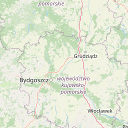
Map view of Studzienickie Torfowiska

Use this park location map to pinpoint Studzienickie Torfowiska in Poland, understand its exact geographic position, and read its mapped placement within the surrounding landscape more clearly.

Pigeon | © OpenStreetMap contributors

Location context for Studzienickie Torfowiska

Pomeranian Voivodeship
Park atlas

Compare adjacent wetland habitats and regional lowland conservation landscapes

Explore Parks Near Studzienickie Torfowiska and Surrounding Protected Areas

Browse other protected areas and wetland reserves located near Studzienickie Torfowiska across the Pomeranian region. Comparing adjacent lowland habitats and bog ecosystems provides deeper geographic context for regional conservation networks.
Protected landscapePomeranian Voivodeship
7.7 km away#1 closest

South

Zaborski Park Krajobrazowy: Geographic Profile of a Polish Protected Landscape Area

Tuchola Forest region, Pomeranian Voivodeship

Investigate the unique terrain of Zaborski Park Krajobrazowy, a protected landscape defined by its dense network of glacial lakes and sandy outwash plains. This territory provides a comprehensive view of northern Polish lowland geography, highlighting the ecological significance of its river valleys and relic forest habitats within the broader Tuchola Forest ecosystem.

Area
340.3 km²
Established
1990
Relief
Lowland
Climate
Temperate
A soft watercolor illustration depicting a flat wetland landscape with low hills in the background and clusters of green trees and shrubs in the foreground.
Nature reservePomeranian Voivodeship
About 9.3 km away#2 closest

Southwest

Mechowisko Radość Nature Reserve: Atlas of Protected Alkaline Fen Landscapes in Pomeranian Voivodeship

A rare calcareous mire ecosystem within the Bory Tucholskie post-glacial terrain

Mechowisko Radość Nature Reserve protects a specialized alkaline peatland ecosystem that developed in a formerly mesotrophic lakeside bay. This site highlights the complex hydrological and ecological processes of the Bory Tucholskie region, where flat, post-glacial landscapes sustain rare orchid and bryophyte assemblages through dedicated active conservation management.

Area
0.096 km²
Established
2013
Relief
Lowland
Scope
Terrestrial
Protected areaPomeranian Voivodeship
12 km away#3 closest

South

Sandr Brdy: Protected Glacial Landscapes and Hydrological Networks in Pomeranian Voivodeship

A vital reference site for lowland habitat conservation and post-glacial terrain.

Sandr Brdy spans 7,492 hectares of outwash plains in northern Poland. Its terrain hosts a complex mosaic of calcareous fens, acid oak forests, and lobelia lakes, established to preserve fragile aquatic and terrestrial species like the gray wolf and lady's slipper orchid within a unique glacial framework.

Area
74.926 km²
Scope
Terrestrial
Water
Major water bodies
Watercolor painting of a soft, hazy wetland landscape with green foliage, pink marsh vegetation, and distant hills in pale tones.
Nature reservePomeranian Voivodeship
About 13 km away#4 closest

South

Rezerwat przyrody Dolina Kulawy: Mapping Peatlands and Wetlands in Pomeranian Voivodeship

A protected landscape featuring soligenous mires and glacial lakes.

Discover the intricate geography of Rezerwat przyrody Dolina Kulawy, a nature reserve centered on the Kulawa River valley in northern Poland. This protected area offers a unique look at soligenous peatlands, floodplain forests, and mesotrophic lake systems, providing essential context for the post-glacial landscape of the Bory Tucholskie region.

Area
1.546 km²
Established
2009
Relief
Lowland
Climate
Temperate
A soft watercolor painting of gentle, rolling hills and scattered trees under a light sky.
Protected areaPomeranian Voivodeship
17 km away#5 closest

West

Ostoja Masłowiczki: Protected Landscape and Post-Glacial Terrain in Pomeranian Voivodeship

Exploring the glacial basins, bogs, and forests of northern Poland.

Ostoja Masłowiczki is a protected area in the Bytów Lake District defined by its glacial heritage. The site provides a unique look at how moraine landscapes support a varied mosaic of habitats, ranging from acidic dystrophic lakes and active raised bogs to lush oak-hornbeam and beech forests within the Pomeranian region.

Area
16.8 km²
Established
2011
Relief
Lowland
Climate
Temperate
Nature reservePomeranian Voivodeship
About 19 km away#6 closest

Northeast

Rezerwat przyrody Mechowiska Sulęczyńskie: Geography and Protected Area Landscape Analysis

Alkaline fen and peatland habitat in Pomeranian Voivodeship

Study the geographic distribution and protected status of Rezerwat przyrody Mechowiska Sulęczyńskie, an essential alkaline fen ecosystem in northern Poland. This reserve highlights the role of groundwater-fed landscapes in maintaining orchid populations and bryophyte-rich mires within a post-glacial region. The site serves as a reference point for peatland conservation and structural landscape integrity.

Area
0.252 km²
Established
2014
Relief
Lowland
Climate
Temperate
Protected landscapePomeranian Voivodeship
About 23 km away#7 closest

Southeast

Wdzydzki Park Krajobrazowy: Protected Landscape and Post-Glacial Lakeland Geography

Explore glacial lake networks and Tuchola Forest woodlands

Wdzydzki Park Krajobrazowy preserves a major post-glacial lakescape, characterized by the irregular Lake Wdzydze and its dense surroundings of pine forests, bog islands, and river-linked basins. This protected area in the Pomeranian Voivodeship provides a critical look at the integration of freshwater ecosystems and coniferous terrain, offering an essential reference for understanding the geography of northern Poland.

Area
178.32 km²
Established
1983
Relief
Lowland
Climate
Temperate
A pale, soft-toned watercolor painting of a calm lake shore with marshy grasses in the foreground and a line of green trees and rolling hills in the background.
National parkPomeranian Voivodeship
27 km away#8 closest

South

Park Narodowy „Bory Tucholskie”: Geography of a Polish National Park and Protected Forest

Lowland pine ecosystems and glacial water networks

Located in the Pomeranian Voivodeship, Park Narodowy „Bory Tucholskie” protects a significant remnant of the Tuchola Forest. The terrain, characterized by postglacial sandy plains, inland dunes, and acidic lobelia lakes, provides a critical reference site for studying forest ecology and glacial geomorphology within the Polish national park system.

Area
46.13 km²
Established
1996
Visitors
33K annual
Relief
Lowland

Common questions about visiting, size, designation, and location context for Studzienickie Torfowiska

Studzienickie Torfowiska FAQs for park facts, access, geography, and protected area context

Find quick answers about Studzienickie Torfowiska, including protected-area facts, park geography, trail and visitor context, and how the park fits into its surrounding country and regional landscape.
MoriAtlas Explorer

Continue Your Protected Areas Search Across the Global Atlas

Deepen your exploration by continuing the structured search for national parks and protected areas worldwide. Utilize the comprehensive filtering capabilities to compare different conservation landscapes and refine your understanding of global park geography. Discover more about the distribution and characteristics of protected natural areas.

Global natural geography