Mori Atlas logo
Nature reserveStühe

Explore the glacial terrain and dense woodland mosaic defining this protected area in Oldenburg

Stühe Nature Reserve: Mapping the Protected Forest Landscapes of the Delmenhorster Geest

(Naturschutzgebiet Stühe)

Stühe Nature Reserve encompasses a 217-hectare protected woodland block situated within the glacially shaped Delmenhorster Geest of northwestern Germany. This area features a complex mosaic of mature European beech and oak-hornbeam forests, acid oak woodlands, and riparian floodplain corridors along the Welse valley. The terrain includes unique natural monuments like the Margaretenmoor bog hollow and the Sphagnum-covered Schlatt im Stühe, creating a dense, structurally rich ecosystem.

beech forestlowland forestnature reserveFFH sitemoss moorbog woodland

Stühe

Nature reserve

Park overview

Structured park overview, official facts, and landscape profile for Stühe

Stühe park facts, protected area profile, and essential visitor context

Review the core facts for Stühe, including designation, size, terrain, visitor scale, habitats, and operating context in one park-focused overview.

About Stühe

Stühe is a wooded area on the Delmenhorster Geest, the gently undulating sandy lowland between Delmenhorst and the Hunte valley. The forest occupies the northeastern corner of the municipality of Dötlingen, with smaller portions extending east into the municipality of Ganderkesee, and is traversed by the district road K 327, which was widened in 2016 and provided with a cycle path.

The forest is elongated east to west, roughly 2.8 kilometres along its long axis and between 0.8 and 1.5 kilometres across. The full woodland block, including the Welsburger Wiesen meadows that lie to its north and belong to the regional forestry district, totals about 340 hectares. About 217 hectares of that area have been protected as the Naturschutzgebiet Stühe since December 2018, almost identical in extent with the underlying EU FFH site.

Ecologically, Stühe represents the typical but unusually well-preserved forest landscape of the Oldenburg district. Its core is formed by Hainsimsen-Buchenwald, a community of European beech adapted to moderately acidic soils, enriched with smaller stands of oak-hornbeam forest and acidophilous oak forest. Small bog woodlands dominated by downy birch and alder buckthorn grow in the wetter depressions, and a narrow fringe of black alder and common ash occupies the floodplain along the eastern margin near the Immer Bäke stream. Hedgerows, traditionally classified as Wallhecken, knit the forest together with surrounding meadows and farmland.

The nature reserve is deeply rooted in long-standing local use. From 1898, after the opening of the Delmenhorst-Hesepe railway, the station at Immer served as the Sunday outing destination for inhabitants of Delmenhorst and Bremen, and several inns and guest houses were opened along the forest edge. After the Second World War excursion traffic ceased almost entirely.

Since 1962, the forest has been home to a herd of European fallow deer released after being held in an acclimatisation enclosure, with today's population estimated at around 80 animals. The reserve carries an FFH classification at the European level, and the landscape falls within the larger Landschaftsschutzgebiet Welsetal und Stühe. The Hasen-Ahlers-Weg trail, named after a 19th-century local outlaw and poacher who lived for many years in a sheepfold in the forest, runs through the woods, and a successor oak was planted near the site of the historic Freeschenboom in 1981 in memory of the forest's older, larger oak.

Quick facts and research context for Stühe

Stühe lies in the Oldenburg district of Lower Saxony, southwest of Delmenhorst, between the villages of Klattenhof and Immer. The broader woodland covers around 300 hectares, of which about 217 hectares have been a formally designated nature reserve since 22 December 2018, with the designation NSG WE 312. Roughly 209 hectares of that area coincide with an EU FFH (Fauna-Flora-Habitat) site.

The forest is dominated by European beech woodland with associated oak and oak-hornbeam communities, together with small pockets of bog woodland, riparian alder-ash woodland, hedges, meadows, and stillwaters. A fallow deer population introduced in 1962, currently estimated at around 80 animals, is one of its most distinctive wildlife features. The landscape is the historically forested part of the Delmenhorster Geest, and it also forms part of the larger landscape protection area Welsetal und Stühe.

Protection and recognition

Documented terrestrial designation history and Natura 2000 records for Stühe

Stühe Protection Status and International Recognition Data

Stühe holds documented terrestrial protected area status established in 2018 alongside official Natura 2000 recognition records. Analysis of these administrative sources provides clear insight into the conservation framework governing the landscape.

International recognition

Protection details

Protection scope
Terrestrial
Designated year
2018
Transboundary protection
No
Park context

Deeper park guide and search-rich context for Stühe

Stühe history, landscape, wildlife, and travel context

Explore Stühe through its history, landscape character, ecosystems, wildlife, conservation priorities, cultural context, and seasonal travel timing in a structured park guide built for atlas discovery and search intent.

Why Stühe stands out

Stühe is best known for its extensive, structurally rich beech forest with a high proportion of old and dead wood, a hallmark of mature Central European woodland. Another defining trait is the conservation mosaic: within just a few hundred hectares it juxtaposes Hainsimsen-Buchenwald, mixed oak and oak-hornbeam stands, acid oakwoods, small birch bogs, an alder-ash floodplain strip, hedges, meadows, and kettle-style stillwaters. The forest is also notable for its integration of two protected natural monuments: Margaretenmoor, a birch bog woodland in a damp hollow, and Schlatt im Stühe, a small former lake basin with a Sphagnum moss cover. Together these elements give Stühe a compact but unusually complete ecological profile for a forest reserve in the northwest German lowlands.
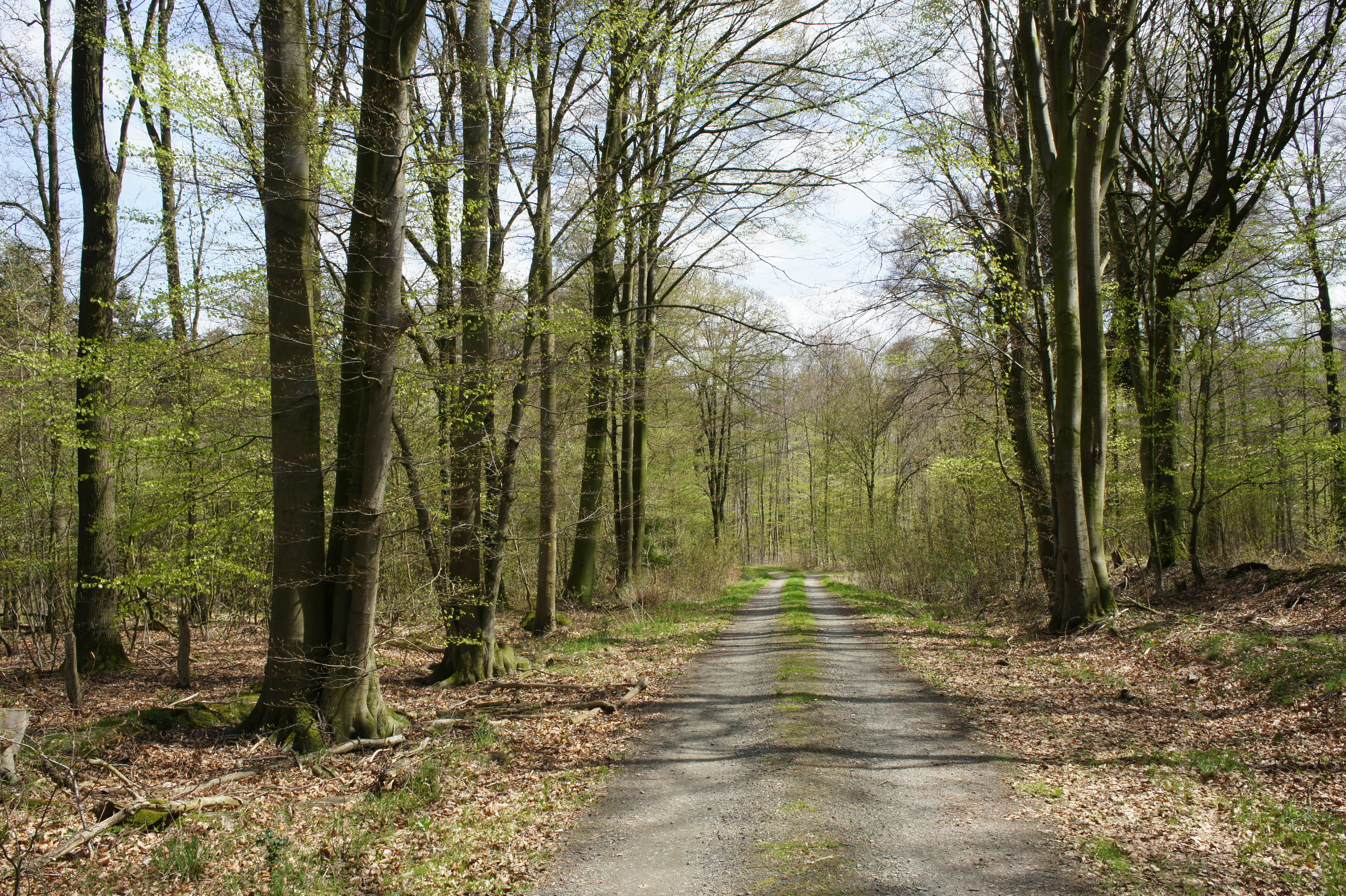
A narrow dirt path leading through a dense, mature beech forest in spring, with fresh green leaves visible on the trees and leaf litter on the ground.
A dirt path through the beech forest of Stühe nature reserve.

Stühe history and protected-area timeline

The Stühe as a woodland has long been part of the rural landscape of the Dötlingen and Ganderkesee area, used both for forestry and for traditional grazing and harvesting of the surrounding meadows and small moors. The forest's role as a local recreation area began in 1898, when the Delmenhorst-Hesepe railway opened and the station at Immer became the Sunday outing destination for residents of Delmenhorst and Bremen. Within the same year the Gasthof Witte opened opposite the station, followed in the next few years by the Waldschlösschen inn at Immer and, to the west along the Bassumer Weg, the inn called Zum Hasen Ahlers, named after the local figure Hasen-Ahlers.

With the end of the Second World War, excursion traffic ceased almost entirely, and two of the three forest-edge inns had to close. The name Hasen-Ahlers was commemorated later in the trail that leads through the forest, while the inns themselves gradually disappeared from active use.

In February 1962, six fallow deer were brought from the Eilenriede in Hanover into an acclimatisation enclosure in Stühe, followed by a seventh animal; the herd was released into the forest by the end of 1962 and has since built up a self-sustaining population estimated at around 80 animals.

The forest's largest and oldest single tree, the Freeschenboom or Frieseneiche, with a trunk circumference of about 10 metres at its base, broke apart under its own weight in May 1889. In April 1981, the village community of Klattenhof and the district forester planted a successor oak at the fork towards Bergedorf in memory of both the original tree and the Hollandgänger tradition of seasonal labour migration to the Netherlands. The landscape received formal nature conservation recognition on 22 December 2018, with the establishment of the Naturschutzgebiet Stühe, created by integrating large parts of the older Landschaftsschutzgebiet; the two natural monuments Margaretenmoor and Schlatt im Stühe were absorbed into the new reserve.

Stühe landscape and geographic character

The Stühe occupies a stretch of the Delmenhorster Geest, a glacially shaped, gently undulating plain of sandy and loamy soils that characterises the countryside southwest of Delmenhorst. The forest is elongated east to west, about 2.8 kilometres long and 0.8 to 1.5 kilometres wide, creating a compact but clearly bordered woodland block on the otherwise open farmland of the Geest.

Within the larger forest area, small landscape features create a finely textured mosaic. The eastern margin is framed by the Immer Bäke, a short tributary of the Welse. Depressions within and adjoining the woodland hold boggy hollows and former kettle-like small waterbodies; one of them became the protected natural monument Margaretenmoor, a birch bogwood-filled damp hollow, and another, the Schlatt im Stühe, an old lake basin now carpeted in Sphagnum mosses.

Along the northern edge, the Welsburger Wiesen meadows extend the green character of the area, providing a transition between forest and open farmland. Hedgerows of the regional Wallhecken type border the woodland on several sides, while a district road crosses the forest from west to east, and the Delmenhorst-Hesepe railway forms part of its eastern boundary.

Stühe ecosystems, habitats, and plant life

Stühe is ecologically a lowland north-German forest reserve, yet unusually rich in forest types for its size. The core community is the Hainsimsen-Buchenwald, a beech woodland on moderately acidic soils dominated by European beech with minor amounts of pedunculate oak. Accompanying it are oak-hornbeam woods, acidophilous oak forests, and small but ecologically significant patches of bog forest, alder floodplain forest, and hedgerow.

The beech stands carry a well-developed understorey of forest grasses, sedges, and woodland herbs, alongside ericaceous plants such as bilberry and Sphagnum mosses in moister pockets. The oak-hornbeam communities are richer in flowering woodland species, with wood anemone, enchanter's nightshade, greater stitchwort, and climbing corydalis, while the acidophilous oak stands are marked by plants such as bracken and common bent.

Wet features are integral to the reserve. The Margaretenmoor contains a birch bog forest with Sphagnum mosses and sedges, including cottongrass species, while the Schlatt im Stühe is a small Sphagnum-covered basin. The stillwaters in and around Stühe carry floating and emergent aquatic plants such as broad-leaved pondweed, frogbit, floating sweet-grass, and white water-lily, reflecting the influence of groundwater in the local depressions.

The forest's structure is an important element of its nature value: the woodland is characterised by a high share of old trees and substantial deadwood, providing habitat continuity for fungi, saproxylic insects, and cavity-using birds and bats over many decades.

Stühe wildlife and species highlights

The most distinctive mammalian feature of Stühe is its free-ranging population of European fallow deer, introduced from the Eilenriede in Hanover in 1962 and now estimated at around 80 animals. The animals roam the forest and adjoining meadows, shaping forest regeneration and contributing to the maintenance of open glades within the woodland.

The reserve's high proportion of old trees and deadwood makes it particularly important for saproxylic insects, fungi, and the bird and bat species that depend on tree cavities, bark crevices, and decaying wood. The mosaic of beech, oak, bog forest, stillwaters, and meadows supports a wide range of breeding birds typical of north-west German broadleaf woodland complexes, including woodland raptors and woodpeckers, while the open water bodies and surrounding meadows provide conditions for amphibians and dragonflies associated with small forest pools.

Wet-edge features, particularly the Margaretenmoor and Schlatt im Stühe with their Sphagnum-rich vegetation, provide habitat for wetland-specialist invertebrates and plants beyond what the surrounding beech forest alone could support.

Stühe conservation status and protection priorities

Stühe matters for conservation on three overlapping scales. Locally, almost the entire forest block is protected as the Naturschutzgebiet Stühe, designation NSG WE 312, established on 22 December 2018, and is supervised by the Oldenburg district as the responsible lower nature conservation authority. Within this area, the Margetenmoor and the Schlatt im Stühe are protected as natural monuments.

At the European level the area coincides almost exactly with an EU FFH site of about 209 hectares, recognising it as part of the Natura 2000 network that protects habitats and species of European importance. The presence of specific habitat types, including Hainsimsen-Buchenwald, oak-hornbeam woodland, acidophytic oak forest, bog forest, and alder-ash floodplain woodland, is what underpins this classification.

The remaining portions of the wider Stühe area are incorporated into the Landschaftsschutzgebiet Welsetal und Stühe, ensuring that the surrounding landscape along the Welse river valley and the adjoining meadows retain their open, traditional character. The reserve's value is enhanced by a large share of old and deadwood, an essential structural element for the long-term survival of specialist woodland species, and by the presence of fallow deer as a long-established large herbivore shaping the forest's dynamics.

Stühe cultural meaning and human context

Stühe occupies a small but meaningful place in the local cultural memory of the Dötlingen and Ganderkesee area. The forest gained cultural visibility as a Sunday outing destination after 1898, when the Delmenhorst-Hesepe railway made it easily reachable from the industrial towns of Delmenhorst and Bremen, and three inns opened along the forest edge to serve day-trippers. After the Second World War this leisure tradition ended abruptly and two of the inns were closed, marking a quiet transition in the role of the forest within local life.

Earlier still, the forest had been a gathering point for the Hollandgänger, seasonal labour migrants who would set out together from the Freeschenboom, a monumental historical oak known also as the Frieseneiche, to seek work in the Netherlands as grass mowers, peat cutters, or sailors. The oak itself fell in 1889 after centuries of life, and a successor oak planted in 1981 honours that tradition. The Hasen-Ahlers-Weg, named after a 19th-century local poacher who lived in a sheepfold in the forest, similarly ties the woodland to the rural social history of the region. The Romantics also made Stühe visible through art: in 1865 the landscape painter Louis Preller published a woodcut of the heron-rich core of the forest, capturing the area's image for readers of the widely circulated Illustrirte Zeitung.

Top sights and standout views in Stühe

Stühe's standout features are its well-developed beech forest complexes with abundant old growth and deadwood, the tightly interwoven mosaic of beech, oak, oak-hornbeam, bog, and floodplain forests, and the inclusion of two natural-monument-protected small bogs. The free-ranging fallow deer herd introduced in 1962 adds a distinctive large-mammah dimension that is rare among nature reserves in the district.

Visitors walking the Hasen-Ahlers-Weg pass at the same time through the historical heart of the forest, with the Klattenhof-Bergedorf fork and the site of the Freeschenboom remaining meaningful local landmarks. The integration of the reserve into the larger Landschaftsschutzgebiet Welsetal und Stühe provides a wider landscape setting in which woodland, meadows, hedgerows, and river valley can be appreciated together.

Best time to visit Stühe

Stühe can be visited throughout the year, but the late spring and early summer months are particularly rewarding for walking the forest paths, when the beech canopy is fully in leaf, the woodland floor is rich with flowering plants such as wood anemones and climbing corydalis, and the stillwaters and meadows support active amphibian and insect life. Late summer brings warm evenings and the strong visual contrast between bright green meadows and the deeper-toned woodland.

Autumn is the classic season for enjoying the mature beech forest at its most colourful, with the russet canopy, the first fallen leaves, and the beginning of visible fungal fruiting bodies across the high deadwood share. In winter the beech forest offers quiet, open views through the bare stands and the chance to see fallow deer more readily against the leafless backdrop, especially in the more open meadow-margin areas along the Strüher Wiesen and Welsburger Wiesen.


Monthly climate preview

Measured monthly weather patterns and representative climatology data for Stühe

Stühe Climate Normals, Long-Term Temperature and Precipitation Rhythms

Representative coordinate measurements record Stühe monthly temperature variations alongside steady precipitation averages across the year. Exploring the complete twelve-month climatology profile reveals deeper numerical trends for long-term meteorological analysis.
Annual mean9 °C
1 °C18 °C
Jan
Feb
Mar
Apr
May13°
Jun16°
Jul18°
Aug18°
Sep14°
Oct10°
Nov
Dec
Warmest month
July

18 °C

Coolest month
January

1 °C

Wettest month
July

2.5 mm/day

Driest month
April

1.4 mm/day

Park location guide

Geography guide, regional context, and park location map for Stühe

Stühe park geography, regions, and map view in Germany

Understand where Stühe sits in Germany through a broader geographic reading of the surrounding landscape, nearby location context, and its mapped position within the national park landscape.

How Stühe fits into Germany

Germany is a federal republic in Western and Central Europe with a population of over 83 million across sixteen constituent states. It is Europe's largest economy by nominal GDP and a major global exporter and importer. The capital is Berlin, and the country borders Denmark, Poland, Czech Republic, Austria, Switzerland, France, Luxembourg, Belgium, and the Netherlands.

Wider geography shaping Stühe in Germany

Germany is located in Western and Central Europe, spanning 357,022 km². It borders Denmark to the north, Poland and the Czech Republic to the east, Austria and Switzerland to the south, and France, Luxembourg, Belgium, and the Netherlands to the west. The country has coastlines on the Baltic Sea and North Sea to the north, with the Alps located in the southern region.

Map view of Stühe

Use this park location map to pinpoint Stühe in Germany, understand its exact geographic position, and read its mapped placement within the surrounding landscape more clearly.

Pigeon | © OpenStreetMap contributors

Location context for Stühe

Lower SaxonyOldenburg
Recorded earthquake history

Explore Historical Earthquake Records Associated with Stühe Nature Reserve

Examine the history of recorded seismic events near the Stühe forest landscape. This MoriAtlas catalogue provides structured access to historical earthquake data for the area, allowing for informed exploration of recorded regional ground activity.

Stühe Earthquake History

Catalogued events

2 events

Strongest magnitude

Magnitude 4

Most recent event

Jul 2, 2006

This history includes earthquakes recorded inside the park or within 50 km of its borders

Explore high-resolution photography capturing the rare beech woodlands, bogs, and glacial terrain of Stühe.

Stühe Photos and Landscape Scenery: Visualizing the Protected Forest Environment

Visual documentation reveals the intricate conservation mosaic of ancient beech stands, acid oakwoods, and damp kettle bogs across the protected lowland reserve. Photographic records provide clear spatial context for understanding the glacial terrain, forest structures, and varied habitats that define the landscape.

A narrow dirt path leading through a dense, mature beech forest in spring, with fresh green leaves visible on the trees and leaf litter on the ground.

A large moss-covered boulder in a deciduous forest with the text Freeschen Boom carved on it, next to an informational sign on a metal stand.

Park atlas

Compare nearby lowland forests, regional nature reserves, and connected woodland habitats.

Other Parks Near Stühe and Related Protected Areas in the Surrounding Region

Continue exploring protected areas near Stühe by browsing adjacent lowland forests and regional nature reserves across the surrounding landscape. Comparing these nearby woodland habitats provides a broader geographic perspective on northwest German conservation corridors.
Nature reserveLower Saxony
8.4 km away#1 closest

Northeast

Stenumer Holz Nature Reserve: Protected Ancient Woodland Geography in Lower Saxony

A detailed map-based overview of ancient oak and beech forest ecosystems

Stenumer Holz functions as a critical nature reserve within the Oldenburg district, preserving an ancient broadleaf forest mosaic that stretches across 96 hectares of sandy-geest terrain. The area is defined by its diverse structural composition, including moist oak-hornbeam stands, drier Luzula beech ridges, and narrow alluvial corridors that support specialized woodland flora and old-growth ecological features.

Area
0.96 km²
Established
2018
Relief
Lowland
Climate
Temperate
Nature reserveLower Saxony
About 8.8 km away#2 closest

South

Wunderburger Moor Nature Reserve: Mapped Bog Habitats and Lower Saxony Geography

Protecting a dense mosaic of mire and peatland landscapes

Wunderburger Moor in Lower Saxony represents a significant protected example of a small bog landscape, or Kleinmoor. The reserve contains a compact range of habitat types, including moor heath, reedbeds, and wet birch woodland, providing a clear window into the ecological diversity of northwestern German peatlands within a managed site.

Area
0.34 km²
Established
1967
IUCN
IV
Relief
Lowland
Nature reserveOldenburg
11 km away#3 closest

West

Tannersand und Gierenberg Nature Reserve: Inland Dunes and Bog Pool Mapping

Protected sandy geest landscape within the Osenberge near Oldenburg

Tannersand und Gierenberg represents a vital nature reserve featuring an unusual inland dune system and embedded wetland Slatts. The protected area exhibits a dense contrast between coniferous dune ridges and peat-moss-rich swamps. This record details the park boundaries, landscape mosaic, and the specific terrain that classifies it as a significant protected site within Lower Saxony, Germany.

Area
0.35 km²
Established
1938
Nature reserveBremen
About 17 km away#4 closest

Northeast

Ochtumniederung bei Brokhuchting: Wetland Nature Reserve and Floodplain Geography

A core conservation area within the Bremen Niedervieland

This protected area stands as a primary example of large-scale river floodplain restoration in the Bremen region. The landscape includes a dense network of canals, reedbeds, and seasonal flood zones that provide critical shelter for waterfowl and waders. Through careful environmental management, this site integrates natural riverine terrain with the surrounding industrial and urban framework of northwestern Germany, offering a distinct study of managed wetland ecosystems.

Area
3.75 km²
Established
1998
Relief
Lowland
Climate
Temperate
A watercolor painting showing a soft, panoramic view of a flat wetland area with green trees, a solitary tree in the middle, and industrial silos faintly visible in the background.
Nature reserveBremen
About 19 km away#5 closest

Northeast

Hochwasserschutzpolder zwischen Senator-Apelt-Straße und Neustädter Hafen: Bremen Protected Lands

A vital wetland reserve integrating flood management and avian biodiversity in the port district.

Located within the port district of Bremen, the Hochwasserschutzpolder zwischen Senator-Apelt-Straße und Neustädter Hafen is a notable protected area that balances essential flood-control infrastructure with rich ecological functions. The reserve sustains a variety of wetland bird populations across its reed-lined waters and alluvial woodlands, providing a critical haven for wildlife amidst the surrounding industrial and urban development of the Lower Weser region.

Area
0.847 km²
Established
2014
IUCN
IV
Nature reserveBremen
About 20 km away#6 closest

Northeast

Dunger See Nature Reserve: Mapped Protected Wetland and Landscape Geography in Bremen

A structured geographic look at the Werderland bird protection habitat.

Dunger See is a compact, ecologically diverse nature reserve in Bremen, shaped by intentional land management to provide critical nesting and wintering grounds for wildfowl. This protected area stands out for its indented shoreline, artificial island clusters, and surrounding woodland buffers that contrast with the open agricultural terrain of the wider Werderland landscape.

Area
0.33 km²
Established
1990
Relief
Lowland
Climate
Temperate
A horizontal watercolor painting depicting a soft-focus landscape with a pond in the foreground, pink and green heath vegetation, and distant tree lines under a pale sky.
Nature reserveBremen
About 21 km away#7 closest

North

Eispohl, Sandwehen und Heideweiher: Protected Landscape and Geest Geography

Nature reserve featuring historic dunes and heath pond networks

This nature reserve in Bremen protects a remnant of the Rekumer Geest, featuring a complex of inland dunes, wet heath, and small heath ponds. Through its combination of extensively grazed grasslands and mixed forests, the area serves as a vital habitat corridor, maintaining the traditional Geest landscape patterns that once dominated the region between Bremen and the lower Weser.

Area
0.036 km²
Established
1988
Relief
Lowland
Climate
Temperate
Nature reserveBremen
About 22 km away#8 closest

Northeast

Hammersbecker Wiesen: Protected Nature Reserve and Meadow Landscape in Bremen

Ecological mosaic of wet meadows and stream valley terrain

Hammersbecker Wiesen encompasses 25.8 hectares of ecologically significant wet grassland and hedgerow habitats in Bremen. This nature reserve provides an essential refuge for diverse plant species and local amphibians within an urban-adjacent setting, illustrating the preserved character of traditional northern German meadow systems.

Area
0.258 km²
Established
1986

Common questions about visiting, size, designation, and location context for Stühe

Stühe FAQs for park facts, access, geography, and protected area context

Find quick answers about Stühe, including protected-area facts, park geography, trail and visitor context, and how the park fits into its surrounding country and regional landscape.
MoriAtlas Explorer

Continue Your Protected Areas Search Across the Global Atlas

Deepen your exploration by continuing the structured search for national parks and protected areas worldwide. Utilize the comprehensive filtering capabilities to compare different conservation landscapes and refine your understanding of global park geography. Discover more about the distribution and characteristics of protected natural areas.

Global natural geography