

Mori Atlas logo
Nature reserveSüdhang Ettersberg

Explore the geographic boundaries, terrain features, and ecological mosaic of this landmark central German protected area.

Südhang Ettersberg Nature Reserve: Mapping the Protected Slopes and Landscapes of Thuringia

(Naturschutzgebiet Südhang Ettersberg)

Südhang Ettersberg represents a vital nature reserve located on the southern slopes of the Ettersberg ridge near Weimar, Germany. Spanning roughly 408 hectares, the area protects an essential mosaic of dry grassland, scrub, and mixed woodland that characterizes this warm, south-facing terrain in Thuringia. By tracing its boundaries and understanding the surrounding microtopography, observers gain insight into the conservation of dry-slope ecosystems and their regional significance.

nature reservedry grasslandsouthern slopemixed woodlandthermo-vegetationthorn scrub
A flat-style vector illustration of a scenic valley with grassy plains in the foreground, a dense forest in the midground, and steep cliffs with a waterfall in the background.

Südhang Ettersberg

Nature reserve

Park overview

Structured park overview, official facts, and landscape profile for Südhang Ettersberg

Südhang Ettersberg park facts, protected area profile, and essential visitor context

Review the core facts for Südhang Ettersberg, including designation, size, terrain, visitor scale, habitats, and operating context in one park-focused overview.

About Südhang Ettersberg

Südhang Ettersberg is a nature reserve that captures one of the most ecologically distinctive settings in the immediate vicinity of Weimar: the south-facing slopes of the Ettersberg, where elevation, exposure, and soil conditions combine to support a habitat mosaic uncommon elsewhere in the district. Although the reserve covers only about 408 hectares, it represents the single largest contiguous block of protected land in the Weimarer Land and includes the adjacent Bernhardtsberg, extending the area's topographic and ecological diversity. The reserve's defining character comes from the interplay between open dry grassland, scrub transitions, and deciduous or mixed woodland typical of warm, sunlit slopes. These conditions attract thermophilic plant communities and a wide variety of invertebrates, which in turn sustain rich bird and small-fauna populations. The contrast between the warmer southern slopes and cooler northern aspects gives the Ettersberg landscape a layered biological identity that is unusually compressed into a small footprint. Since 2015, the NABU-Stiftung Nationales Naturerbe has acquired roughly 289 hectares within the reserve, transforming the area from a designated protection zone into a site where conservation goals are backed by direct land ownership. This shift has enabled more intensive habitat management and monitoring, exemplified by the 2016 NABU-Tag der Artenvielfalt, which documented 314 plant species, 76 spider species, 60 bird species, 33 wild bee species, 30 butterfly species, 28 snail species, five amphibian species, and two reptile species, along with hundreds of additional insect records. The reserve is therefore not only a refuge for native biodiversity but also an active site for ongoing ecological survey and management. Geographically, the reserve sits between the city of Weimar to the south and the wider Weimarer Land farming landscape to the north, with the L 1054, B 7, and B 85 forming outer boundary references. Despite this proximity to roads and urban areas, the sloping core of the reserve retains a strong sense of natural continuity, making it a meaningful local escape within one of Thuringia's most culturally significant regions.

Quick facts and research context for Südhang Ettersberg

Südhang Ettersberg is a designated nature reserve in Thuringia, Germany, classified as IUCN Category IV (Habitat/Species Management Area). It lies on the southern slope of the Ettersberg, north of the Weimar district of Gaberndorf, and spans the city of Weimar and the surrounding Weimarer Land district. With roughly 408 hectares, it is the largest nature reserve in the Weimarer Land district and includes the Bernhardtsberg. The reserve was formally established in 1997 under nature protection legislation and carries the official designation NSG-Nr. 323. Between 2015 and 2017, the NABU-Stiftung Nationales Naturerbe acquired approximately 289 hectares of the area, strengthening long-term conservation ownership. The surrounding road network, including the L 1054, B 7, and B 85, marks the boundary of the protected slopes rather than penetrating them.

Protection and recognition

Examine the terrestrial protection scope and documented conservation records

Südhang Ettersberg Protection Status and International Recognition Data

Südhang Ettersberg maintains a documented terrestrial protection status within global conservation databases. Verified administrative records outline the official designation framework and management framework governing this protected terrain.

Protection details

Protection scope
Terrestrial
WDPA ID
165783
Park context

Deeper park guide and search-rich context for Südhang Ettersberg

Südhang Ettersberg history, landscape, wildlife, and travel context

Explore Südhang Ettersberg through its history, landscape character, ecosystems, wildlife, conservation priorities, cultural context, and seasonal travel timing in a structured park guide built for atlas discovery and search intent.

Why Südhang Ettersberg stands out

Südhang Ettersberg is best known for its exceptionally species-rich dry grassland and warm woodland mosaic on the southern face of the Ettersberg near Weimar. South-facing slopes in this part of Thuringia create microclimates that favor rare plants, diverse insect communities, and a mix of open and forested habitat types. The reserve is also recognized as a major conservation acquisition for the NABU-Stiftung Nationales Naturerbe, which now owns the majority of the area. The 2016 NABU-Tag der Artenvielfalt survey, which documented hundreds of species across plants, spiders, birds, wild bees, butterflies, snails, amphibians, and reptiles, helped establish the site as a regional hotspot for biodiversity on a relatively compact area.
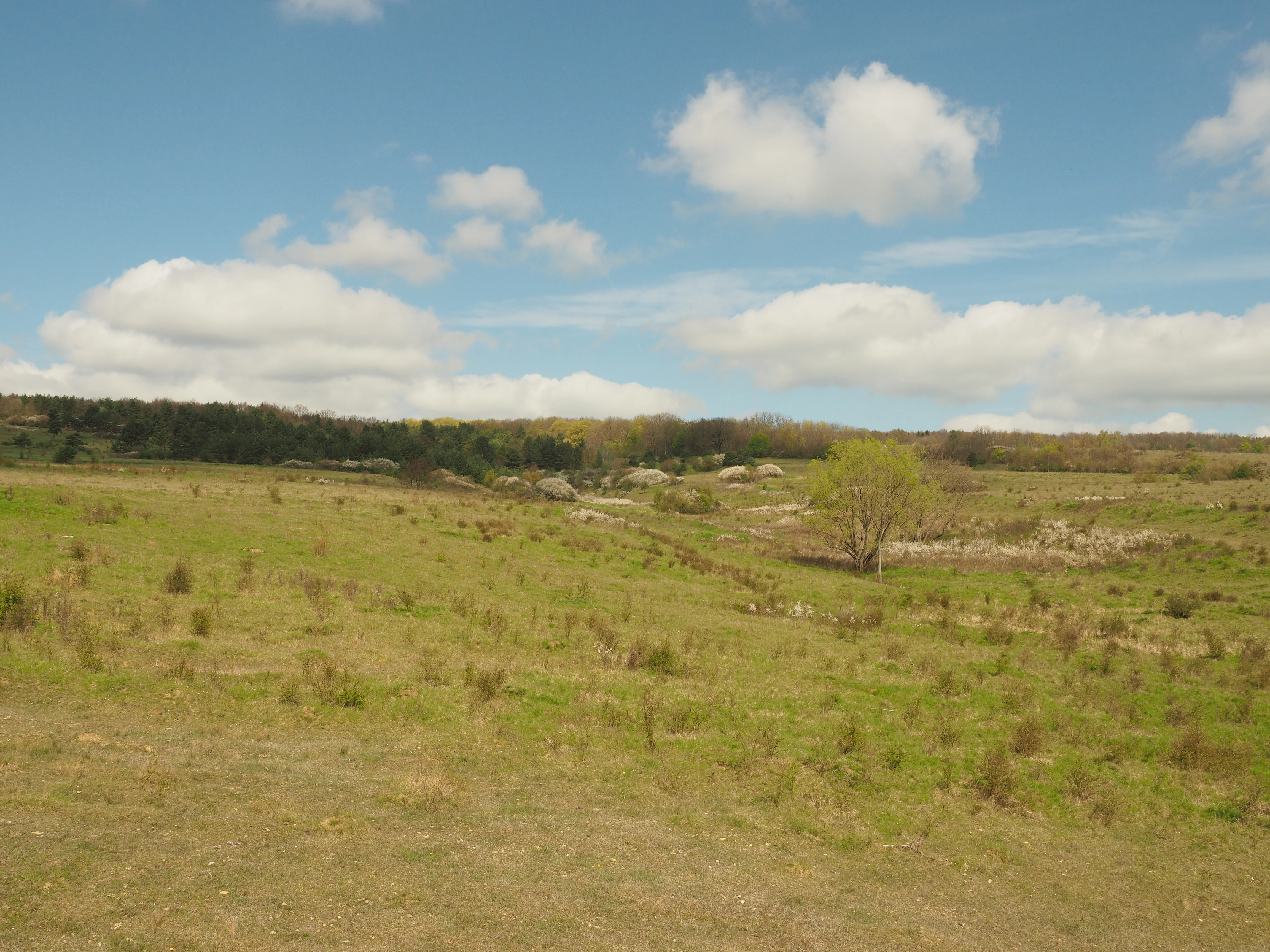
A wide view of a grassy meadow with scattered vegetation under a blue sky with white clouds, bordered by a forested slope in the background.
A spring meadow landscape within the Sudhang Ettersberg nature reserve.

Südhang Ettersberg history and protected-area timeline

Südhang Ettersberg was formally designated as a nature reserve in 1997, receiving the official German nature protection designation NSG-Nr. 323. Its establishment recognized the high ecological value of the Ettersberg's southern slope, including the Bernhardtsberg, where dry grasslands and warm woodland habitats had long supported regionally significant biodiversity. A turning point in the reserve's modern history came between 2015 and 2017, when the NABU-Stiftung Nationales Naturerbe acquired approximately 289 hectares of the protected area. This made the reserve one of the foundation's significant holdings in Thuringia and shifted management toward long-term conservation stewardship under a dedicated national nature heritage framework. In June 2016, the NABU-Stiftung hosted the NABU-Tag der Artenvielfalt at the Ettersberg, organizing a broad-based biodiversity survey to establish a clearer picture of the species composition across plants, invertebrates, birds, and other animal groups. The survey produced an unusually detailed snapshot of reserve biodiversity and helped frame subsequent conservation priorities for the site.

Südhang Ettersberg landscape and geographic character

The reserve covers the southern slope of the Ettersberg ridge, a prominent landform in the countryside north of Weimar. The slope's south-facing exposure is the defining topographic feature, shaping both climate and vegetation across roughly 408 hectares and the included Bernhardtsberg hill. The terrain combines gentle to moderately steep slopes, small dry valleys, and ridgeline transitions, creating a varied microtopography. In the surrounding area, several small stream features such as the Dürrebaumgraben, Rödelgraben, Katzgraben, and Lützendorfer Graben shape the broader drainage pattern, though the reserve itself is defined more by slope and exposure than by active watercourses. The result is a landscape that feels distinctly warmer and more open than the surrounding lowlands, with long views over the Weimarer Land farmland.

Südhang Ettersberg ecosystems, habitats, and plant life

Südhang Ettersberg protects a characteristic mosaic of dry grassland, scrub, and forest on a south-facing slope, a habitat combination that is relatively rare in the Thuringian lowlands. Warm microclimates on the slope support thermophilic plant communities, while transitions to woodland create structural diversity that benefits insects, birds, and small mammals. The broader ecological context of the reserve places it within a network of protected sites around Weimar and the Weimarer Land, where similar dry and warm habitats are preserved in smaller fragments. Südhang Ettersberg stands out within this network because it concentrates these habitats over a relatively large and continuous area, allowing species and ecological processes to persist at a scale that fragmented sites cannot support.

Südhang Ettersberg wildlife and species highlights

Wildlife in Südhang Ettersberg is closely tied to the dry grassland and warm woodland mosaic that defines the reserve. The 2016 NABU biodiversity day recorded 60 bird species, 33 wild bee species, 30 butterfly species, 76 spider species, 28 snail species, five amphibian species, two reptile species, and hundreds of insect species, indicating a rich and varied fauna across many groups. The combination of open sunlit slopes and adjacent forest patches provides favorable conditions for invertebrates, which in turn support insectivorous birds and other predators. Reptiles and amphibians benefit from the warm dry slopes combined with small-scale moisture gradients, while the mix of habitats allows both ground-nesting and shrub-associated species to find suitable conditions within the reserve.

Südhang Ettersberg conservation status and protection priorities

Südhang Ettersberg carries formal nature reserve status under Thuringian and German law and is classified as an IUCN Category IV Habitat/Species Management Area, reflecting an emphasis on managing specific habitats and species rather than full wilderness protection. The reserve is the largest of its kind in the Weimarer Land district, giving it a central role in regional habitat conservation. Between 2015 and 2017, the NABU-Stiftung Nationales Naturerbe acquired about 289 hectares within the reserve, making the site a key Thuringian holding of the foundation. This ownership model supports long-term conservation management, scientific survey, and habitat stewardship beyond what regulatory designation alone would provide. The site is registered in the World Database on Protected Areas under WDPA ID 165783, and its monitoring history, including the 2016 NABU-Tag der Artenvielfalt, has helped establish the reserve as an important reference site for dry-slope biodiversity in central Germany.

Südhang Ettersberg cultural meaning and human context

The reserve lies in the immediate cultural orbit of Weimar, a city of major literary, artistic, and political importance in German history. While Südhang Ettersberg is itself a natural landscape, its setting on the Ettersberg ridge places it within the same regional identity that shaped figures such as Goethe and the wider Thuringian cultural landscape tradition. The protected slope also represents the broader pattern of small, ecologically distinctive reserves embedded in culturally significant regions of Thuringia, where nature protection and heritage landscapes coexist on a very local scale.

Top sights and standout views in Südhang Ettersberg

Südhang Ettersberg's greatest strengths lie in the size and continuity of its dry-slope habitats, which is unusual for the Weimarer Land district. The reserve offers a compact but ecologically rich setting where grassland, scrub, and forest meet along a single south-facing slope and the included Bernhardtsberg. Its ownership by the NABU-Stiftung Nationales Naturerbe gives the site a stronger conservation foundation than many comparable local reserves, and the depth of biodiversity recorded during the 2016 survey helps position Südhang Ettersberg as a benchmark dry-slope site for the wider region.

Best time to visit Südhang Ettersberg

The reserve's character shifts subtly with the seasons, with spring offering the most active display of flowering plants on the dry slopes and the peak of insect and bird activity during the warmer months. Late spring and early summer amplify the contrast between the open dry grassland and the wooded sections of the slope, when wild bees, butterflies, and other invertebrates are most active. Autumn brings quieter conditions and shifts the reserve's visual emphasis toward the woodland and scrub on the southern slope, while winter exposes the underlying landform of the Ettersberg more clearly. Visitors seeking the strongest expression of the reserve's grassland flora and insect life should favor the warmer months, while those interested in landscape form and quieter walking may prefer the cooler seasons.

Monthly climate preview

Long-term representative measurements detailing monthly temperature ranges and precipitation trends

Südhang Ettersberg Climate Normals, Annual Temperature and Precipitation Rhythm

Südhang Ettersberg exhibits a measured annual cycle of temperature and precipitation based on long-term representative coordinate records spanning multiple decades. Examining the complete monthly climate normals reveals detailed seasonal variations in average maximum and minimum temperatures alongside daily precipitation averages.
Annual mean9 °C
-1 °C19 °C
Jan-1°
Feb
Mar
Apr
May13°
Jun17°
Jul19°
Aug19°
Sep14°
Oct
Nov
Dec
Warmest month
July

18.9 °C

Coolest month
January

-1 °C

Wettest month
July

2.5 mm/day

Driest month
April

1.3 mm/day

Park location guide

Geography guide, regional context, and park location map for Südhang Ettersberg

Südhang Ettersberg park geography, regions, and map view in Germany

Understand where Südhang Ettersberg sits in Germany through a broader geographic reading of the surrounding landscape, nearby location context, and its mapped position within the national park landscape.

How Südhang Ettersberg fits into Germany

Germany is a federal republic in Western and Central Europe with a population of over 83 million across sixteen constituent states. It is Europe's largest economy by nominal GDP and a major global exporter and importer. The capital is Berlin, and the country borders Denmark, Poland, Czech Republic, Austria, Switzerland, France, Luxembourg, Belgium, and the Netherlands.

Wider geography shaping Südhang Ettersberg in Germany

Germany is located in Western and Central Europe, spanning 357,022 km². It borders Denmark to the north, Poland and the Czech Republic to the east, Austria and Switzerland to the south, and France, Luxembourg, Belgium, and the Netherlands to the west. The country has coastlines on the Baltic Sea and North Sea to the north, with the Alps located in the southern region.

Map view of Südhang Ettersberg

Use this park location map to pinpoint Südhang Ettersberg in Germany, understand its exact geographic position, and read its mapped placement within the surrounding landscape more clearly.

Pigeon | © OpenStreetMap contributors

Location context for Südhang Ettersberg

Thuringia

Visualizing dry grassland habitats and protected terrain across the Thuringian ridge

Südhang Ettersberg Photos and Landscape Scenery Explorer

Photographic records reveal the distinct dry grassland mosaic, scrub vegetation, and warm southern slopes defining the Südhang Ettersberg protected area. Visual exploration of the terrain clarifies how slope exposure and varied microclimates shape habitat patterns across the Thuringian landscape.

A wide view of a grassy meadow with scattered vegetation under a blue sky with white clouds, bordered by a forested slope in the background.

Park atlas

Compare regional nature reserves and connected conservation landscapes across Thuringia

Parks Near Südhang Ettersberg and Surrounding Protected Area Geography

Browsing other protected areas near Südhang Ettersberg reveals the wider ecological connectivity of central German dry grassland habitats. Comparing adjacent reserves helps place local woodland and slope ecosystems into a broader regional conservation context.
Protected landscapeThuringia
About 15 km away#1 closest

South

Landschaftsschutzgebiet Mittleres Ilmtal: Protected Landscape Geography and Map Discovery

Thuringia regional atlas and protected area profile

Gain insight into the diverse topography of Landschaftsschutzgebiet Mittleres Ilmtal, which spans roughly 150 square kilometers. This protected landscape is characterized by its dramatic shifts from Buntsandstein forests in the Tannrodaer Sattel to the elevated Muschelkalk escarpments, offering a detailed case study in German mid mountain geography.

Area
150 km²
Relief
Upland
Climate
Temperate
Access
Access unknown
Nature reserveWeimarer Land
About 17 km away#2 closest

South

Seeteich Blankenhain Nature Reserve: Geographic Map and Protected Area Context

Wetland landscape situated in the Weimarer Land district

Seeteich Blankenhain is a distinct nature reserve in Germany, characterized by its historic pond and surrounding moist lowland ecosystems. This site remains a focal point for ecological research and conservation, offering a layered landscape of reed zones and woodland that supports a diverse bird community. Its presence within the regional geography of Weimarer Land highlights the importance of small-scale wetland preservation in the Thuringian landscape.

Established
1991
Relief
Lowland
Access
Access unknown
Scope
Terrestrial
A soft watercolor painting of a green landscape with trees, rolling hills, and a body of water under a light sky.
Nature reserveThuringia
About 18 km away#3 closest

Southeast

Jenaer Forst Nature Reserve: Mapping the Protected Limestone Plateau and Forest Terrain

Protected nature reserve in Thuringia, Germany

Jenaer Forst is a 540 hectare nature reserve in Thuringia, characterized by dry calcareous woodland and active restoration work. The site is a study in landscape recovery, balancing forest management with the protection of orchid-rich habitats on its limestone plateau. This detailed atlas entry provides insights into the park boundaries, geological features, and ecological significance of this peri-urban forest zone.

Area
5.411 km²
Established
2008
IUCN
IV
Nature reserveThuringia
About 21 km away#4 closest

East

Windknollen Nature Reserve: Mapping Protected Limestone Landscapes in Thuringia

Examining the plateau geography and former training site boundaries

The Windknollen nature reserve occupies a distinct position on the Muschelkalk limestone plateau near Jena. Its protected status reflects an evolution from historical battlefield use to a formal conservation area within the National Natural Heritage framework. The terrain is defined by exposed; dry-adapted vegetation across 185 hectares of highland geography.

Area
1.851 km²
Established
1997
IUCN
IV
Watercolor painting of a rolling landscape with green and muted red washes, depicting the Schwellenburg hill region.
Nature reserveThuringia
About 23 km away#5 closest

West

Schwellenburg Nature Reserve: Mapping the Gypsum Karst Landscapes of Thuringia

A study of xerothermic grasslands and historical geological terraces.

The Schwellenburg is an elongated ridge of gypsum bedrock that creates a sharp topographic contrast to the surrounding agricultural plains of the Thuringian Basin. This nature reserve serves as an important botanical and entomological site, where historical quarrying has shaped a series of distinct, stepped terraces that host specialized, heat-loving vegetation typical of steppe environments.

Area
0.225 km²
Established
1939
Relief
Upland
Climate
Temperate
Nature reserveThuringia
About 24 km away#6 closest

Southeast

Leutratal und Cospoth Nature Reserve: Mapping Calcareous Grasslands in Thuringia

A study of limestone slopes and orchid-rich habitats in central Germany

Leutratal und Cospoth serves as a prime example of protected Muschelkalk landscape in Thuringia. This reserve captures the complex transition between open grasslands, scrub, and beech forests within the middle Saale valley, offering deep insights into the region's unique geological and botanical heritage.

Area
5.829 km²
Established
1961
IUCN
IV
Relief
Upland
Nature reserveThuringia
About 26 km away#7 closest

East

Lohholz Nature Reserve: Protected Forest and Meadow Mosaic in Thuringia

Mapped deciduous woodlands and river valley meadow geography

Lohholz constitutes an isolated nature reserve in Thuringia, showcasing a distinct mosaic of broadleaf forest and traditional orchard meadows. The terrain slopes toward the Saale river valley, featuring varied grassland communities and a vital spring-fed brook. This protected area offers a look at forest preservation within a landscape predominantly utilized for agricultural purposes.

Area
0.304 km²
Established
1995
IUCN
IV
Relief
Upland
A horizontal watercolor illustration showing green rolling hills, distant light green ridges, and sparse trees against a white background.
Nature reserveThuringia
About 26 km away#8 closest

Southeast

Spitzenberg-Schießplatz Rothenstein-Borntal Nature Reserve and Saale Valley Geography

Protected forest and grassland terrain in Thuringia

Spitzenberg-Schießplatz Rothenstein-Borntal is a protected nature reserve in Thuringia, covering hundreds of hectares of forest slopes, plateaus, and open clearings. This reserve is recognized for its unusual structural diversity, ranging from closed valley woodland to sun-exposed semi-dry grassland, providing essential habitat within the middle Saale valley region.

Area
5.542 km²
Established
1961
IUCN
IV

Common questions about visiting, size, designation, and location context for Südhang Ettersberg

Südhang Ettersberg FAQs for park facts, access, geography, and protected area context

Find quick answers about Südhang Ettersberg, including protected-area facts, park geography, trail and visitor context, and how the park fits into its surrounding country and regional landscape.
MoriAtlas Explorer

Continue Your Protected Areas Search Across the Global Atlas

Deepen your exploration by continuing the structured search for national parks and protected areas worldwide. Utilize the comprehensive filtering capabilities to compare different conservation landscapes and refine your understanding of global park geography. Discover more about the distribution and characteristics of protected natural areas.

Global natural geography