Mori Atlas logo
Nature reserveSüdtannenmoor

Mapping the relict heath pool systems and rare wetland flora of the Emsland

Südtannenmoor Nature Reserve: A Protected Bog Landscape in Lower Saxony, Germany

Südtannenmoor represents a compact, ecologically focused nature reserve situated within the Emsland district of Lower Saxony. This protected landscape preserves a rare mosaic of transitional bog, heath pools, and open water basins that serve as vital habitats for specialized wetland flora. Understanding the terrain and boundaries of this site provides insight into the historic distribution of bog-reliant plant species across the northwest German plains.

bogheath poolwetlandnature reserveLower SaxonyEmsland

Südtannenmoor

Nature reserve

Park overview

Structured park overview, official facts, and landscape profile for Südtannenmoor

Südtannenmoor park facts, protected area profile, and essential visitor context

Review the core facts for Südtannenmoor, including designation, size, terrain, visitor scale, habitats, and operating context in one park-focused overview.

About Südtannenmoor

Südtannenmoor is a compact but ecologically dense nature reserve in the gently undulating lowlands of the Emsland in northwestern Lower Saxony. From the outside, the reserve appears as a small clearing in an otherwise forested matrix, with two former heath pools embedded among stands of pine and spruce. Yet within this modest footprint, the area preserves a sequence of habitats, from open water and mineral-rich aquatic vegetation to transitional and raised-bog communities, that gives it an outsized importance for regional botanical conservation.

The reserve's identity is shaped by water, or more precisely by the slow loss of water over recent decades. The two historic heath pools that once defined the site have responded very differently to regional hydrological change: one has completely dried out and been reclaimed by moor birch, Scots pine, and willow scrub, while the other, the northern pool, still retained open water and its characteristic vegetation communities into the early twenty-first century. Around their margins, relict raised-bog species such as Sphagnum magellanicum, Drosera rotundifolia, Erica tetralix, and Rhynchospora alba still occur, though the spread of Molinia caerulea (purple moor grass) is gradually altering the structure of these communities.

Südtannenmoor is part of the network of nature reserves in Landkreis Emsland that together protect fragments of the historical Hümling moor and heath landscape. Its protected status, its alignment with IUCN's Habitat/Species Management Area category, and its recognition within the World Database on Protected Areas reflect a deliberate effort to maintain the ecological conditions necessary for the reserve's most threatened species to persist in a region where similar habitats have largely vanished.

Quick facts and research context for Südtannenmoor

Südtannenmoor is a protected nature reserve (Naturschutzgebiet) in Landkreis Emsland, Lower Saxony, designated under the official code NSG WE 044 and recorded in the World Database on Protected Areas as WDPA-ID 82669. The reserve lies near the Hümmling region, an area known for its surviving heath and bog habitats, and was established under its current legal framework on 31 December 2009, replacing an earlier ordinance from 25 June 1959 that is no longer in force.

The site is a Habitat and Species Management Area under IUCN Category IV, primarily focused on protecting wetland, bog, and heath plant communities. It is administered by the Niedersächsischer Landesbetrieb für Wasserwirtschaft, Küsten- und Naturschutz (NLWKN) and belongs to a broader network of small nature reserves in the Emsland district that safeguard relict wetland biodiversity.

Protection and recognition

Analysis of terrestrial protected area designation and recognition records.

Südtannenmoor Protection Status and Documented Conservation Scope

Documented protection status records for Südtannenmoor outline the established terrestrial management scope and administrative framework. Verified conservation records assemble official designation data and international recognition sources for structural geographic analysis.

Protection details

Protection scope
Terrestrial
Transboundary protection
No
WDPA ID
82669
Park context

Deeper park guide and search-rich context for Südtannenmoor

Südtannenmoor history, landscape, wildlife, and travel context

Explore Südtannenmoor through its history, landscape character, ecosystems, wildlife, conservation priorities, cultural context, and seasonal travel timing in a structured park guide built for atlas discovery and search intent.

Why Südtannenmoor stands out

Südtannenmoor is best known as one of the last strongholds in northwestern Germany of Scheuchzeria palustris, the Blumenbinse or Blasenbinse, a highly specialised bog-plant species that had nearly disappeared from the region by the 1970s. The reserve also preserves a compact mosaic of heath-pool, transitional bog, and former raised-bog vegetation within an area of only a few hectares. It is equally valued for its surviving populations of other bog indicators such as round-leaved sundew (Drosera rotundifolia), cranberry (Vaccinium oxycoccos), white beak-sedge (Rhynchospora alba), and bog cottongrass (Eriophorum vaginatum), which together document the site's character as a relict of once more widespread northwest German bog landscapes.
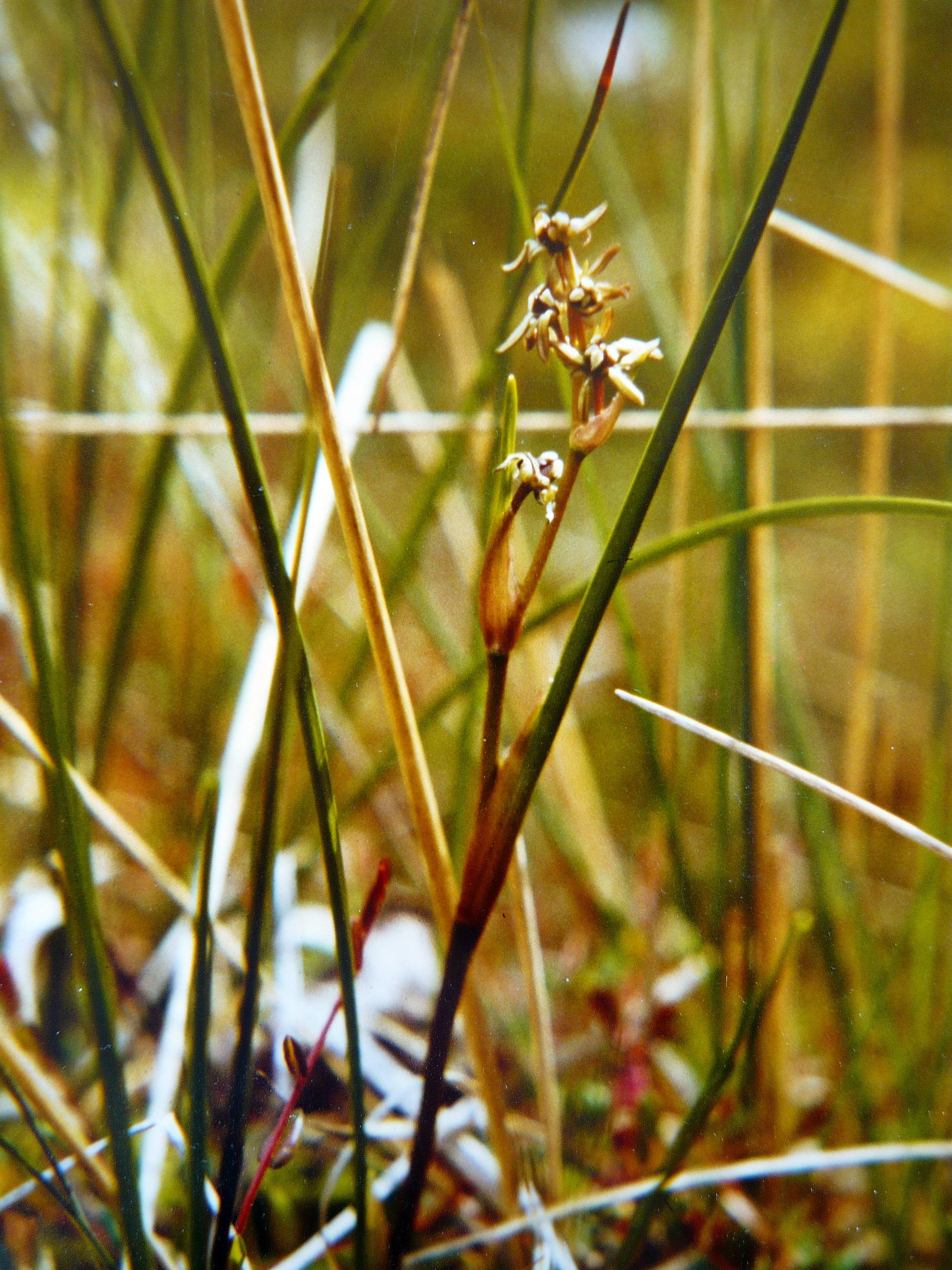
A close-up view of the Rannoch-rush, Scheuchzeria palustris, showing its slender stems and small, light-colored flowers set against a background of green and brown moorland grasses.
A detailed view of Scheuchzeria palustris growing in the Südtannenmoor nature reserve.

Südtannenmoor history and protected-area timeline

The first formal protection of the area around the Südtannenmoor heath pools was established on 25 June 1959, when a conservation ordinance was issued covering what would later be reclassified and refined as the modern reserve. That early ordinance has since been formally deleted, and a renewed ordinance came into force on 31 December 2009, bringing the reserve under its current legal framework and reaffirming its status as a Naturschutzgebiet in Lower Saxony.

Beyond administrative milestones, the site carries a longer ecological history documented by decades of botanical surveys. In the mid-twentieth century, the pools and their margins hosted a rich and unusual bog flora studied by researchers such as Carl Altehage in 1955, who described the Scheuchzeria-rich moors of the Hümmling as important natural monuments of northwestern Germany. By the 1970s, the rare Blumenbinse had declined dramatically, with only 25 flowering plants documented in 1976, prompting renewed conservation attention and hydrological management concerns.

Südtannenmoor landscape and geographic character

The physical setting of Südtannenmoor is a low-lying section of the northwest German plain, with elevations of roughly 24 to 30 metres above sea level and coordinates around 52°45′ N, 7°28′ E. The reserve occupies a shallow depression in the landscape, and its two pools are separated only by a low sandy ridge (Sandrücken), a typical feature of the sand-dominated heath pool systems of the Emsland and Hümmling regions.

Surrounding the pools, the landscape transitions abruptly into planted coniferous forest, with stands of Scots pine and spruce dominating the immediate visual setting. The smaller pool, once about 50 by 95 metres across, has been transformed into a bowl of wet woodland and scrub, where moor birch, pine, and willow now define the local micro-landscape. The larger, northern pool still preserves a more open character, with floating water-lily leaves and fringing sedge stands softening its outline into the surrounding mire.

Südtannenmoor ecosystems, habitats, and plant life

Ecologically, Südtannenmoor is best understood as a layered mosaic of wetland habitats compressed into a very small area. The open-water zone of the surviving northern pool is characterised by white water lily (Nymphaea alba), with fringing communities of bottle sedge (Carex rostrata) and bogbean (Menyanthes trifoliata) that suggest a moderate, rather than extremely nutrient-poor, water chemistry. Narrow-leaved cottongrass (Eriophorum angustifolium) appears locally around the margins and contributes to the pool's distinctive early-summer appearance.

Around the edges of the still-open pool, transitional and bog-like vegetation persists, with Sphagnum magellanicum as a structuring species. Within this moss layer, classic raised-bog indicators occur, including round-leaved sundew (Drosera rotundifolia), cranberry (Vaccinium oxycoccos), sheathing cottongrass (Eriophorum vaginatum), cross-leaved heath (Erica tetralix), and white beak-sedge (Rhynchospora alba). The dried-out southern basin, meanwhile, has shifted to a different ecological state dominated by soft rush (Juncus effusus), purple moor grass (Molinia caerulea), and developing scrub, illustrating the dynamic trajectory of many former bog pool sites in the region.

Südtannenmoor wildlife and species highlights

Although Südtannenmoor is primarily recognised for its botanical value, the reserve also supports characteristic wetland fauna associated with its pool and bog communities. In early summer, the surviving northern pool is reported to host a notable chorus of green frogs, whose calls become a defining sound of the site. Above the water surface, numerous dragonflies are observed, contributing to the rich insect life typical of heath-pool and bog-margin habitats.

The reserve's combination of open water, fringing bog vegetation, and adjacent forest edges provides habitat structure for typical northwest German wetland fauna, even though detailed faunal inventories are not the main focus of the reserve's protection. The presence of stable populations of sensitive bog plants also implies functioning hydrological and microclimatic conditions that benefit a wider range of mire-dependent invertebrates and amphibians.

Südtannenmoor conservation status and protection priorities

The conservation significance of Südtannenmoor is closely tied to the dramatic decline of bog and heath-pool habitats across northwestern Germany, and to the near-disappearance of several specialist bog species from the region. The reserve is classified by the IUCN as a Category IV Habitat/Species Management Area, meaning that active management is a recognised component of its conservation purpose. Its official designation as NSG WE 044 in Lower Saxony, combined with its inclusion in the World Database on Protected Areas under WDPA-ID 82669, places it firmly within both national and international frameworks for protected-area recognition.

A central conservation focus is the protection of the Blumenbinse (Scheuchzeria palustris), whose population trajectory at the site illustrates both the vulnerability and the recovery potential of carefully managed bog habitats: from hundreds or thousands of plants in the 1950s, to just 25 flowering individuals in 1976, to over 1,000 plants recorded again in 2011. At the same time, the spread of Molinia caerulea and the drying-out of parts of the site due to regional groundwater lowering reflect the broader hydrological pressures affecting Emsland bogs, making continued monitoring and, where possible, hydrological management essential to the reserve's long-term viability.

Südtannenmoor cultural meaning and human context

Südtannenmoor lies within the historical cultural landscape of the Hümmling, a region long associated with heathland, small-scale agriculture, and scattered forest patches in the Emsland. The reserve's name itself, linking "Tannen" (referring locally to conifers, especially pines and firs) with "Moor" (moor or bog), reflects the long-standing local perception of these forest-fringed mire patches as distinctive features of the regional landscape.

There are no significant built-cultural monuments within the protected area itself; its cultural context is primarily that of a small, tightly defined natural area valued by successive generations of regional botanists and conservationists. The detailed mid-twentieth-century botanical surveys of the Hümmling moors, particularly Altehage's 1955 study, give the site a recognised place in the scientific-cultural history of nature documentation in northwestern Germany.

Top sights and standout views in Südtannenmoor

Within only a few hectares, Südtannenmoor preserves a striking cross-section of small-scale wetland ecosystems, from a still-open heath pool with white water lilies and fringing sedge communities, to dry-fallen basins now turning into birch and willow scrub, and to transitional raised-bog margins still hosting Sphagnum, sundews, and cottongrass.

The reserve's standout feature is its population of Scheuchzeria palustris, a bog specialist that was nearly lost from northwestern Germany in the 1970s and has recovered at this site to over a thousand recorded individuals by 2011, marking Südtannenmoor as a key reference location for the conservation of the species in the region.

Best time to visit Südtannenmoor

The character of Südtannenmoor changes with the seasons in ways that are typical of small northwest German wetland and bog sites. In early summer, the reserve is at its most visually expressive: the surviving pool is at its fullest, dragonflies are active above the water surface, green frogs are audible in the surrounding vegetation, and narrow-leaved cottongrass produces its distinctive cotton-like fruiting heads along the margins. This is also typically the period when many of the reserve's characteristic plants, including the rare Blumenbinse, can be observed most readily.

Outside the early-summer window, the vegetation structure is less conspicuous and water levels in the smaller, already dry pool continue to recede into late summer. Autumn brings muted colours to the surrounding coniferous forest and bog margins, while winter visits are largely shaped by the surrounding woodland and the damp, open character of the cleared reserve area, with the wetland communities resting after the growing season.


Monthly climate preview

Long-term monthly temperature and precipitation data for Südtannenmoor

Südtannenmoor Climate Normals and Measured Annual Temperature Patterns

Representative coordinate records show average monthly temperatures ranging from 1.35 degrees Celsius in January to 18.24 degrees Celsius in July alongside recorded precipitation levels. Reviewing the complete twelve-month climate profile reveals long-term temperature ranges and precipitation trends across the protected landscape.
Annual mean10 °C
1 °C18 °C
Jan
Feb
Mar
Apr
May13°
Jun16°
Jul18°
Aug18°
Sep14°
Oct10°
Nov
Dec
Warmest month
July

18.2 °C

Coolest month
January

1.4 °C

Wettest month
December

2.4 mm/day

Driest month
April

1.4 mm/day

Park location guide

Geography guide, regional context, and park location map for Südtannenmoor

Südtannenmoor park geography, regions, and map view in Germany

Understand where Südtannenmoor sits in Germany through a broader geographic reading of the surrounding landscape, nearby location context, and its mapped position within the national park landscape.

How Südtannenmoor fits into Germany

Germany is a federal republic in Western and Central Europe with a population of over 83 million across sixteen constituent states. It is Europe's largest economy by nominal GDP and a major global exporter and importer. The capital is Berlin, and the country borders Denmark, Poland, Czech Republic, Austria, Switzerland, France, Luxembourg, Belgium, and the Netherlands.

Wider geography shaping Südtannenmoor in Germany

Germany is located in Western and Central Europe, spanning 357,022 km². It borders Denmark to the north, Poland and the Czech Republic to the east, Austria and Switzerland to the south, and France, Luxembourg, Belgium, and the Netherlands to the west. The country has coastlines on the Baltic Sea and North Sea to the north, with the Alps located in the southern region.

Map view of Südtannenmoor

Use this park location map to pinpoint Südtannenmoor in Germany, understand its exact geographic position, and read its mapped placement within the surrounding landscape more clearly.

Pigeon | © OpenStreetMap contributors

Location context for Südtannenmoor

Lower Saxony

Visualizing heath pools, relict bogs, and rare wetland flora in Lower Saxony

Südtannenmoor Landscapes and Protected Area Photography

Visual records document the unique terrain, heath pools, and transitional bog habitats found across the Südtannenmoor nature reserve. Examining these protected area photographs provides clear insight into the fragile wetland ecosystems and pine forest borders defining the northern German landscape.

A close-up view of the Rannoch-rush, Scheuchzeria palustris, showing its slender stems and small, light-colored flowers set against a background of green and brown moorland grasses.

Park atlas

Compare regional wetlands, heath pools, and northwest German lowland reserves

Explore Parks Near Südtannenmoor and Surrounding Protected Landscapes

Browse other protected areas near Südtannenmoor to examine related wetland habitats and relict bog ecosystems across the Emsland plain. Extending the geographic review reveals broader conservation patterns within the surrounding lowland terrain.
Nature reserveEmsland
About 11 km away#1 closest

East

Zitterteiche Nature Reserve in Emsland: Mapped Protected Landscapes and Geography

A study of lowland heath ponds and environmental history

Zitterteiche represents a specific, small-scale nature reserve in the Emsland of Germany, consisting of two shallow heath ponds defined by their surrounding agricultural plains. This detailed entry maps the physical terrain and ecological shift of these protected waters, offering a focused perspective on the regional geography and the historical trajectory of this unique, formally protected wetland area.

Area
0.029 km²
Established
1937
IUCN
IV
Relief
Lowland
Protected landscapeEmsland
About 15 km away#2 closest

Northeast

Naturpark Hümmling: Geographic Overview of Emsland Protected Landscapes

Tracing glacial sand ridges, moorlands, and prehistoric cultural sites.

Naturpark Hümmling stands as a prominent protected landscape in Lower Saxony, characterized by its distinctive geest ridge, extensive raised bogs, and dense concentration of Neolithic stone monuments. The area map highlights a complex interplay of river valleys, heathland remnants, and historic cultural landmarks that define the geographical identity of this Emsland treasure.

Area
576 km²
Established
2015
Relief
Upland
Climate
Temperate
Nature reserveEmsland
About 20 km away#3 closest

West

Versener Heidesee Nature Reserve: Mapped Protected Areas in Emsland, Lower Saxony

Heathland habitats and aquatic ecosystems in the Bourtanger Moor region

Versener Heidesee represents a significant example of post-industrial landscape reclamation, where a motorway extraction site was transformed into a protected nature reserve. The site spans 40 hectares, featuring a 16-hectare lake and managed heathland that sustains rare algae species and diverse avian populations. Its location within the International Nature Park Bourtanger Moor-Bargerveen highlights the importance of small-scale, managed terrain for regional ecological health.

Area
0.4 km²
Established
2008
Relief
Lowland
Climate
Temperate
Nature reserveLower Saxony
About 21 km away#4 closest

North

Windelberg Nature Reserve: Protected Inland Dune and Heathland Mosaic in Lower Saxony

Historic sandy heath and oak woodland conservation site

Windelberg is a significant nature reserve in the Emsland region, featuring inland dunes and juniper heathland on the Hümmling glacial ridge. This area showcases a compact mosaic of dry, acidic habitats and relict oak woodland that reflects centuries of traditional land management in northwest Germany. Its status as a protected area within the Natura 2000 network highlights its importance for regional habitat conservation.

Area
0.163 km²
Established
2009
IUCN
IV
Nature reserveLandkreis Emsland
About 21 km away#5 closest

North

Stillgewässer bei Kluse Nature Reserve: Geographic Overview and Protected Wetland Landscape

Mapping the distinctive aquatic corridors of Landkreis Emsland.

Stillgewässer bei Kluse features a compact yet diverse mosaic of standing water pools, floating bog fringes, and oak woodlands on sandy soils. As a protected nature reserve, it functions as a crucial ecological refuge within the Emsland agricultural landscape, offering a unique opportunity to study man-made wetlands that have evolved into mature natural habitats.

Area
0.521 km²
Established
2018
Relief
Lowland
Climate
Temperate
Nature reserveLower Saxony
About 21 km away#6 closest

Northwest

Tausendschrittmoor Nature Reserve: Peatland Recovery and Raised Bog Geography in Emsland

A study in protected lowland peatland landscapes and recovery trajectories

Tausendschrittmoor serves as a vital nature reserve in Lower Saxony, protecting a rare pocket of raised bog habitat amidst an agricultural landscape. The reserve features two contrasting habitats: a rewetted western bog and an eastern bog woodland, each illustrating unique patterns of peatland regeneration on the North German Plain.

Area
0.655 km²
Established
1988
Nature reserveEmsland
About 21 km away#7 closest

West

Südliches Versener Moor Nature Reserve: Emsland Peatland Geography and Protected Landscape

A restored raised bog within the International Nature Park Bourtanger Moor-Bargerveen

Located in Emsland, Südliches Versener Moor is a protected nature reserve defined by its history of peat extraction and ongoing rewetting efforts. The area is part of the larger Bourtanger Moor complex, featuring rare remnants of intact raised bog terrain alongside restored peatland zones that highlight regional conservation dynamics in northwestern Germany.

Area
1 km²
Established
1999
IUCN
IV
Nature reserveLandkreis Osnabrück
About 21 km away#8 closest

Southeast

Suddenmoor Nature Reserve: Mapped Protected Landscapes in Landkreis Osnabrück

Lowland peatland habitats and regional German geography

Suddenmoor serves as a crucial nature reserve in Landkreis Osnabrück, characterized by its flat, peat-rich soil and dense network of drainage channels. The reserve preserves an authentic Artland landscape, featuring a rare combination of wet meadow ecosystems and traditional Wallhecken field boundaries. This protected area stands as a vital connector between larger wetland complexes in the northern German lowland terrain.

Area
3.11 km²
Established
2018
Relief
Lowland
Climate
Temperate

Common questions about visiting, size, designation, and location context for Südtannenmoor

Südtannenmoor FAQs for park facts, access, geography, and protected area context

Find quick answers about Südtannenmoor, including protected-area facts, park geography, trail and visitor context, and how the park fits into its surrounding country and regional landscape.
MoriAtlas Explorer

Continue Your Protected Areas Search Across the Global Atlas

Deepen your exploration by continuing the structured search for national parks and protected areas worldwide. Utilize the comprehensive filtering capabilities to compare different conservation landscapes and refine your understanding of global park geography. Discover more about the distribution and characteristics of protected natural areas.

Global natural geography