
Mori Atlas logo
Nature reserveSwatte Flag

A focused geographic study of small-scale bog margins and rare nutrient-poor grassland habitats.

Swatte Flag Nature Reserve: Mapping the Protected Heathlands and Schlatt Ponds of Lower Saxony

(Naturschutzgebiet Swatte Flag)

Swatte Flag represents a protected fragment of the original bog-edge landscape within Lower Saxony, characterized by its distinct glacial Schlatt ponds. This nature reserve serves as an essential habitat refuge where cottongrass, Sphagnum mosses, and dry heath communities persist amidst an intensively cultivated region. The mapped territory provides a clear case study in habitat management and the preservation of low-elevation sandy outwash terrain.

heathlandnature reserveSchlatt pondswetlandsMagerrasenbog margin
Vector illustration showing a grassy field in the foreground, forest in the midground, and mountains with a cascading waterfall in the background.

Swatte Flag

Nature reserve

Park overview

Structured park overview, official facts, and landscape profile for Swatte Flag

Swatte Flag park facts, protected area profile, and essential visitor context

Review the core facts for Swatte Flag, including designation, size, terrain, visitor scale, habitats, and operating context in one park-focused overview.

About Swatte Flag

Swatte Flag is a small but ecologically focused nature reserve in the North German Plain, located in the district of Rotenburg (Wümme) in Lower Saxony. It sits within the municipalities of Breddorf and Hepstedt, part of the collective municipality of Tarmstedt, and forms a protected fragment on the southern margin of the larger Breddorfer Moor. The reserve covers 16.4 hectares of low-lying terrain at roughly 8 to 9 meters above sea level.

The reserve's core feature is the protection of two Schlatt ponds. Schlatt ponds are shallow, often seasonally fluctuating pools typical of the sandy outwash regions of northwest Germany, formed in natural depressions in the glacial landscape. They tend to support very specific plant communities, particularly where they meet adjacent bog, heath, and nutrient-poor grassland. By protecting both the ponds themselves and a buffer of surrounding open habitat, Swatte Flag preserves an integrated wetland-to-heathland transition that is increasingly rare in the intensively used agricultural matrix of the region.

Swatte Flag has been legally protected as a Naturschutzgebiet since 2 May 1965, giving it one of the longer continuous protection histories in the area. The reserve falls under the responsibility of the district of Rotenburg (Wümme) as the lower nature protection authority, while the Niedersächsischer Landesbetrieb für Wasserwirtschaft, Küsten- und Naturschutz (NLWKN) acts as the responsible state-level technical agency. The reserve is officially classified as IUCN Category IV, a Habitat/Species Management Area, which indicates that its purpose is the active management of particular habitats and species rather than broad wilderness or ecosystem-level protection.

A defining aspect of the reserve is the contrast it presents with its surroundings. The former bog land around the reserve has been drained, cultivated, and converted largely to arable agriculture, leaving only this small patch as a reminder of the original heathland and bog-edge character of the area. Active conservation management, including annual grazing by sheep and goats, helps keep heath and dry grassland communities open and prevents the encroachment of shrubs and trees that would otherwise alter the open habitat character.

Quick facts and research context for Swatte Flag

Swatte Flag is a 16.4 hectare nature reserve located in the district of Rotenburg (Wümme) in Lower Saxony, Germany. It carries the official designation NSG LÜ 054 and was placed under protection on 2 May 1965. The reserve is managed under the authority of the district of Rotenburg (Wümme), with the NLWKN (Niedersächsischer Landesbetrieb für Wasserwirtschaft, Küsten- und Naturschutz) as the responsible state-level nature protection agency.

The site lies between Osterholz-Scharmbeck to the west and Zeven to the east, southwest of the village of Breddorf and within the southern fringe of the Breddorfer Moor. Its terrain is very low, sitting at roughly 8 to 9 meters above sea level. Conservation objectives center on protecting two Schlatt ponds and their surrounding heathland and nutrient-poor grassland communities, with active management through annual grazing by sheep and goats.

Protection and recognition

Documented terrestrial protection scope, designation history, and regulatory context

Swatte Flag Protection Status and International Recognition Details

Swatte Flag conservation metrics bring together verified terrestrial protection scope, management parameters, and official registry sources. Structured factual records outline designated status parameters, administrative boundaries, and international framework identifiers without inferred outcomes.

Protection details

Protection scope
Terrestrial
Transboundary protection
No
WDPA ID
82679
Park context

Deeper park guide and search-rich context for Swatte Flag

Swatte Flag history, landscape, wildlife, and travel context

Explore Swatte Flag through its history, landscape character, ecosystems, wildlife, conservation priorities, cultural context, and seasonal travel timing in a structured park guide built for atlas discovery and search intent.

Why Swatte Flag stands out

Swatte Flag is best known for protecting two Schlatt ponds, a type of shallow natural pond formed in glacial outwash plains that is increasingly rare across the North German landscape. The reserve preserves the open water bodies alongside their characteristic wet and dry heath vegetation, offering a condensed example of the heathland and bog-margin habitats that once covered much of the region. It is also notable for being one of a network of small, targeted nature reserves in the Rotenburg (Wümme) district that act as refuge patches within an otherwise heavily cultivated former moorland landscape. Its habitats include cottongrass-dominated wet zones, Sphagnum moss carpets, dry heath, and Magerrasen (nutrient-poor grassland), all maintained through traditional grazing.
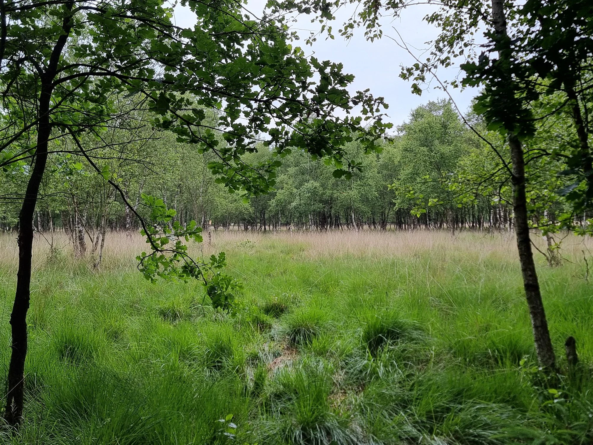
A wide view of a green grassy clearing surrounded by a dense woodland of birch and oak trees.
A view of the open heathland and surrounding forest within the Swatte Flag nature reserve.

Swatte Flag history and protected-area timeline

Swatte Flag was placed under formal nature protection on 2 May 1965, making it one of the earlier small-scale nature reserves in the district of Rotenburg (Wümme). Its designation as a Naturschutzgebiet under the identifier NSG LÜ 054 was part of the broader wave of habitat-focused protections in Lower Saxony during the 1960s, when many small but ecologically valuable sites were secured before further agricultural drainage and intensification could eliminate them.

The surrounding landscape has a different trajectory. The Breddorfer Moor, of which the Swatte Flag site is a southern fragment, was historically a much larger wetland and heathland complex. Much of that former moorland has been drained, cultivated, and converted into farmland, leaving Swatte Flag as a small protected refuge within an agricultural landscape.

Today the reserve is administered locally by the district of Rotenburg (Wümme) as the lower nature protection authority, with the NLWKN providing technical oversight at the state level. Its long-standing classification as IUCN Category IV reflects a management approach aimed at maintaining the specific heathland and pond habitats rather than allowing passive rewilding of the site.

Swatte Flag landscape and geographic character

The landscape of Swatte Flag is typical of the sandy outwash plains of the North German Plain, where glacial meltwater historically left shallow depressions that later filled as ponds and bogs. The reserve lies at an unusually low elevation for the region, between 8 and 9 meters above sea level, reflecting its position within a formerly waterlogged lowland.

Two Schlatt ponds form the central landscape feature. Schlatt is a regional term for naturally formed, shallow pools that often fluctuate seasonally with groundwater levels, sometimes drying out in summer and refilling in wetter periods. Around these ponds, the reserve preserves a mosaic of habitats: wet zones near the water fringe, drier heath and nutrient-poor grassland further out, and Sphagnum-rich bog vegetation in the wettest pockets.

Beyond the reserve boundaries, the landscape changes dramatically. The surrounding former moorland has been cultivated into relatively flat agricultural land, primarily used for arable farming. This sharp transition from open heathland and pond habitats inside the reserve to cropland outside is one of the defining visual and ecological contrasts of the site.

Swatte Flag ecosystems, habitats, and plant life

The ecological identity of Swatte Flag is shaped by the unusual combination of small open-water features, bog vegetation, heathland, and nutrient-poor grassland all within a compact area. The two Schlatt ponds anchor the site ecologically, creating conditions for wet-loving plant communities that include cottongrass, recognizable by its cotton-like fruiting heads in the boggy margins.

Sphagnum mosses colonize suitable wet patches, contributing to peat-forming processes and supporting highly specialized bog microhabitats. Around these wet zones, the reserve transitions into heathland dominated by heather species typical of the northwest German lowlands, with drier areas occupied by Magerrasen, or nutrient-poor dry grasslands. These grasslands often host a rich diversity of specialized herbaceous plants and invertebrates.

The reserves small size gives it a high edge-to-area ratio, which is part of why targeted management is so important. Without active maintenance, shrubs and trees would gradually encroach, shading out the open heath and grassland species. The annual grazing regime with sheep and goats is designed to keep the landscape open and preserve the habitat mosaic that defines the site.

Swatte Flag wildlife and species highlights

The wildlife value of Swatte Flag is closely tied to its heathland, dry grassland, and small pond habitats rather than to large charismatic mammals. The combination of open heath, Magerrasen, Schlatt ponds, and boggy margins supports a wide range of invertebrates, including bees, hoverflies, butterflies, and other pollinators that depend on the late-summer heather bloom and the rich flora of the nutrient-poor grasslands.

The ponds and their surrounding wet zones provide breeding and foraging habitat for amphibians such as frogs and toads, while reptiles typical of warm, dry heath landscapes, including lizards, are likely to use the open, grazed areas. Heather and bog habitats also support characteristic bird species of the northwest German lowlands, including ground-nesting species that depend on open, shrub-free landscapes.

The broader landscape matrix, even though mostly agricultural, means that some larger animals such as roe deer may also pass through the reserve, though the sites small size and open character make it primarily a habitat for smaller, more specialized species.

Swatte Flag conservation status and protection priorities

Swatte Flag plays a focused but important conservation role as a refuge for habitats that were once much more widespread across the Rotenburg (Wümme) district. The surrounding Breddorfer Moor has largely been drained and converted to farmland, eliminating most of the original heathland and bog-edge habitats at landscape scale. The reserve preserves a small but ecologically intact fragment of those former landscapes, including open heath, nutrient-poor dry grassland, Sphagnum-rich bog patches, and two rare Schlatt ponds.

Its IUCN Category IV status as a Habitat/Species Management Area highlights that conservation here is not a hands-off approach. Active management, including the annual grazing of heath and grassland areas with sheep and goats, is central to keeping the open habitat structure intact. This kind of management is essential in lowland heath systems, where the absence of grazing or disturbance allows shrubs and trees to take over within a few years, eventually turning the open heath into closed woodland.

By protecting the ponds together with a buffer of surrounding dry and wet habitats, Swatte Flag also serves as a small-scale example of integrated habitat conservation, ensuring that key ecological transitions, from open water through wet bog to dry heath, are kept together within a single protected unit.

Swatte Flag cultural meaning and human context

The cultural context of Swatte Flag is closely tied to the traditional rural land-use of the northwest German lowlands. Heathlands and Schlatts were historically part of the everyday agricultural landscape, with heath used for grazing and bedding, and shallow ponds integrated into local land-management practices.

The reserves ongoing use of sheep and goat grazing reflects a continuation of these traditional land-use patterns, which once shaped the entire regional landscape. Today, those historic land uses have largely been replaced by intensive arable farming, which is exactly why small reserves like Swatte Flag are sometimes described as cultural-ecological relics: places where both natural habitat and traditional management practices have been preserved together.

The local identity of the area is also shaped by the broader moor history of the district, with the surrounding farmland largely reclaimed from drained bog. The contrast between the cultivated fields and the protected heathland fragment gives the site a particular local significance as a reminder of how dramatically the regional landscape has been altered over the past century.

Top sights and standout views in Swatte Flag

Swatte Flags key qualities include its two protected Schlatt ponds, the compact heathland and Magerrasen mosaic, the Sphagnum and cottongrass-rich bog margins, and the active grazing management that keeps the open habitat character intact.

Its small size and long protection history, dating back to 1965, also make it a useful example of how targeted small-scale reserves can preserve habitat qualities even when much of the surrounding landscape has been converted to agriculture. The sites IUCN Category IV status underscores its role as a managed habitat refuge rather than a wilderness area.

For visitors and researchers interested in northwest German lowland ecology, Swatte Flag offers a particularly clear illustration of heathland-sc Schlatt pond-bog edge transitions within a single small reserve.

Best time to visit Swatte Flag

The reserve is best appreciated in late spring through early autumn, when heath plants and the broader grassland flora are in bloom and the ponds tend to hold water. Late summer is especially characteristic for heather-rich Northwest German heath landscapes, when the heath typically takes on its purple heather bloom.

Spring and early summer can be good for observing wetland vegetation such as cottongrass and for amphibian activity around the ponds. Winters in this low-lying part of Lower Saxony are mild but often damp and grey, and the open heath landscape has less visual color at that time of year.

Monthly climate preview

Long-term temperature and precipitation records sampled at a representative coordinate in Lower Saxony.

Swatte Flag Climate Normals and Measured Annual Temperature Patterns

Representative coordinate measurements record monthly mean temperatures ranging from 1.21 degrees Celsius to 17.88 degrees Celsius alongside consistent daily precipitation rates between 1.36 and 2.57 millimeters. Accessing the complete twelve-month climatology profile provides deeper numerical context for analyzing annual weather cycles.
Annual mean9 °C
1 °C18 °C
Jan
Feb
Mar
Apr
May12°
Jun16°
Jul18°
Aug18°
Sep14°
Oct10°
Nov
Dec
Warmest month
July

17.9 °C

Coolest month
January

1.2 °C

Wettest month
July

2.6 mm/day

Driest month
April

1.4 mm/day

Park location guide

Geography guide, regional context, and park location map for Swatte Flag

Swatte Flag park geography, regions, and map view in Germany

Understand where Swatte Flag sits in Germany through a broader geographic reading of the surrounding landscape, nearby location context, and its mapped position within the national park landscape.

How Swatte Flag fits into Germany

Germany is a federal republic in Western and Central Europe with a population of over 83 million across sixteen constituent states. It is Europe's largest economy by nominal GDP and a major global exporter and importer. The capital is Berlin, and the country borders Denmark, Poland, Czech Republic, Austria, Switzerland, France, Luxembourg, Belgium, and the Netherlands.

Wider geography shaping Swatte Flag in Germany

Germany is located in Western and Central Europe, spanning 357,022 km². It borders Denmark to the north, Poland and the Czech Republic to the east, Austria and Switzerland to the south, and France, Luxembourg, Belgium, and the Netherlands to the west. The country has coastlines on the Baltic Sea and North Sea to the north, with the Alps located in the southern region.

Map view of Swatte Flag

Use this park location map to pinpoint Swatte Flag in Germany, understand its exact geographic position, and read its mapped placement within the surrounding landscape more clearly.

Pigeon | © OpenStreetMap contributors

Location context for Swatte Flag

Lower Saxony
Recorded earthquake history

Explore Recorded Seismic Activity and Earthquake History Near Swatte Flag

Consult the historical catalogue of seismic events identified near the Swatte Flag nature reserve. This data provides a detailed look at past recorded earthquakes, including magnitude and distance information, to assist with a deeper understanding of the seismic context surrounding this protected German landscape.

Swatte Flag Earthquake History

Catalogued events

3 events

Strongest magnitude

Magnitude 4.5

Most recent event

Jul 15, 2005

This history includes earthquakes recorded inside the park or within 50 km of its borders

Visualizing Schlatt ponds, lowland heath, and habitat mosaics

Swatte Flag Photos and Protected Area Landscape Scenery

Photographic records reveal the distinct terrain, shallow Schlatt ponds, and fragile bog-edge vegetation preserved within Swatte Flag. Visualizing these protected habitats clarifies the ecological contrast between the managed heathland reserve and the surrounding agricultural lowlands.

A wide view of a green grassy clearing surrounded by a dense woodland of birch and oak trees.

Park atlas

Compare regional nature reserves and wetland habitats across Lower Saxony

Explore Parks Near Swatte Flag and Surrounding Protected Landscapes

Browse protected areas adjacent to Swatte Flag to examine similar lowland ponds, heath remnants, and bog-margin ecosystems. Comparing nearby reserves reveals how fragmented wetland habitats function within the wider agricultural plains of northern Germany.
Nature reserveLandkreis Osterholz
About 13 km away#1 closest

Southwest

Westliche Hälfte des Langen Moores Nature Reserve in Landkreis Osterholz

A protected mosaic of highmoor peatland geography

Examine the distinct ecological features of Westliche Hälfte des Langen Moores, a protected nature reserve in Landkreis Osterholz. This site offers a compact look at highmoor regeneration and the diverse plant communities found within the historic Teufelsmoor cultural landscape of northern Germany.

Area
0.11 km²
Established
1984
IUCN
IV
A pale, soft-toned watercolor illustration of a calm river meandering through open, green marshy meadows with distant rolling hills under a soft pink sky.
Nature reserveBremen
17 km away#2 closest

South

Borgfelder Wümmewiesen: Protected Wetland and Floodplain Geography in Bremen

An expansive 688-hectare nature reserve with river-fed grasslands.

Borgfelder Wümmewiesen offers a look at one of the largest protected nature reserves in the Bremen region. The landscape is characterized by its flat, open terrain and regular water dynamics that frame a rich mosaic of wet meadows, reedbeds, and ponds, providing essential habitat for breeding and migratory bird species along the Wümme river corridor.

Area
6.88 km²
Established
1987
Relief
Lowland
Climate
Temperate
Nature reserveBremen
18 km away#3 closest

Southwest

Untere Wümme Nature Reserve: Riverine Biodiversity and Protected Tidal Landscapes in Bremen

Protected floodplain geography and tidal river habitats.

This nature reserve protects the meandering lower course of the Wümme river, showcasing one of northern Germany's few freshwater tidal systems. Spanning reedbeds, willow forests, and open mudflats, the reserve forms a vital corridor for migratory fish and waterfowl, reflecting a complex mosaic of protected riverine ecosystems and historic meadow landscapes.

Area
1.485 km²
Established
1991
Relief
Lowland
Climate
Temperate
A soft, painterly watercolor illustration depicting a winding river through a flat green meadow with rolling hills in the background.
Nature reserveBremen
20 km away#4 closest

Southwest

Hollerland Nature Reserve: A Protected Cultural Landscape and Wetland in Bremen

Historic marshland terrain with unique saline spring ecosystems

Hollerland is a 293-hectare nature reserve in Bremen, Germany, notable for its well-preserved cultural landscape of wet grasslands and an intricate medieval ditch network. This protected area serves as a critical breeding ground for meadow birds and hosts an ecologically significant inland saline spring, providing a rare habitat for brackish-adapted plant communities deep within the regional landscape.

Area
2.93 km²
Established
1985
IUCN
IV
Relief
Lowland
Nature reserveLower Saxony
About 21 km away#5 closest

Southeast

Wiestetal Nature Reserve: Mapping the Wieste Stream and Riparian Habitat Corridor

Protected floodplain geography in Lower Saxony, Germany

Wiestetal acts as a critical nature reserve between Mulmshorn and Ottersberg, protecting the unique ecological character of the Wieste lowland stream. The area is defined by its meandering water channels, flooded sand quarry ponds, and diverse forest edges that sustain local biodiversity. This protected landscape offers a detailed look at the interplay between glacial sand deposits and the vibrant aquatic ecosystems of Northern Germany.

Area
3.82 km²
Established
2013
IUCN
IV
Relief
Upland
Nature reserveBremen
21 km away#6 closest

Southwest

Kuhgrabensee Nature Reserve: Mapped Geography and Protected Areas in Bremen

An ecologically vital lake and bird sanctuary in Northwest Germany

Kuhgrabensee serves as a prime example of landscape restoration within Bremen, featuring a groundwater-fed lake with notable saline influences. This protected area supports a diverse array of pioneer plants and wildlife across its reed-lined shores and shallow-water habitats, providing a quiet corridor for ecological observation and study in the heart of the local landscape.

Area
0.296 km²
Established
1987
Relief
Lowland
Climate
Temperate
Nature reserveLower Saxony
About 21 km away#7 closest

Northwest

Wollingster See und Randmoore: A Detailed Map and Geography of This Lower Saxony Nature Reserve

Examining the intersection of glacial lake basins and bog restoration efforts

Wollingster See und Randmoore protects a critical intersection of aquatic and terrestrial ecosystems within Lower Saxony. Learn about the reserve's formation as a potential pingo or glacial pothole, its distinct water quality, and the ongoing efforts to restore its surrounding raised-bog and moor-heath landscape through traditional grazing and rewetting.

Area
1.17 km²
Established
1932
IUCN
IV
Relief
Lowland
Nature reserveLandkreis Rotenburg (Wümme)
22 km away#8 closest

Southeast

Wümmeniederung mit Rodau, Wiedau und Trochelbach: Protected Wetland and Heath Landscape

Regional geography and floodplain connectivity in Landkreis Rotenburg

This nature reserve protects a sprawling lowland landscape characterized by the Wümme, Rodau, Wiedau, and Trochelbach rivers. The terrain features a mosaic of near-natural meandering streams, species-rich wet meadows, and rare raised bog remnants, providing a comprehensive overview of northern German lowland ecology.

Area
28.96 km²
Established
2020
IUCN
IV
Relief
Lowland

Common questions about visiting, size, designation, and location context for Swatte Flag

Swatte Flag FAQs for park facts, access, geography, and protected area context

Find quick answers about Swatte Flag, including protected-area facts, park geography, trail and visitor context, and how the park fits into its surrounding country and regional landscape.
MoriAtlas Explorer

Continue Your Protected Areas Search Across the Global Atlas

Deepen your exploration by continuing the structured search for national parks and protected areas worldwide. Utilize the comprehensive filtering capabilities to compare different conservation landscapes and refine your understanding of global park geography. Discover more about the distribution and characteristics of protected natural areas.

Global natural geography