
Mori Atlas logo
Nature reserveSwatte Poele

Tracing the geological boundaries of the Fensterberge end moraine and its delicate mire ecosystems.

Swatte Poele Nature Reserve: A Protected Glacial Landscape and Heathland Complex in Lower Saxony

(Naturschutzgebiet Swatte Poele)

Swatte Poele serves as a significant protected nature reserve situated along the margins of the Fensterberge end moraine in the German district of Landkreis Osnabrück. The area preserves a mosaic of rare heath ponds, quaking bogs, and coniferous woodland formed by Pleistocene glacial deposits. By analyzing the mapped terrain and habitat boundaries, researchers and nature enthusiasts can better understand the interplay between the site's silting ponds, moisture-dependent flora, and the surrounding sandy landscapes of northwestern Germany.

heath pondsheathlandbogsmirepine forestglacial landscape
A flat-style digital illustration showing a view through tree branches toward a pond, forest, and mountain range under a light sky.

Swatte Poele

Nature reserve

Park overview

Structured park overview, official facts, and landscape profile for Swatte Poele

Swatte Poele park facts, protected area profile, and essential visitor context

Review the core facts for Swatte Poele, including designation, size, terrain, visitor scale, habitats, and operating context in one park-focused overview.

About Swatte Poele

Swatte Poele is a compact but ecologically rich nature reserve in the northern German Pleistocene sand belt, situated near the village of Bippen in the Osnabrück district. The site belongs to a cluster of protected areas that collectively sketch the character of the region's glacial inheritance: rounded ridges, sandy soils, and shallow wetland basins collecting in the low ground between them.

The focal point of the reserve is a chain of three small heath ponds, each surrounded by a distinct ring of mire, heath, and woodland vegetation. These water bodies are slowly filling in through natural succession, a process that over decades converts open water into bog and then into wet woodland. The reserve captures that transition in miniature, offering habitat for bog mosses, cotton grasses, white beak-sedge, bog asphodel, sundews, crowberry, and marsh clubmoss. Floating plants such as white water lily, frogbit, and small bladderwort occupy the open water, while the surrounding shorelines are defined by tall sedges and reeds including floating sweet-grass, common soft-rush, bulbous rush, beaked sedge, and marsh horsetail.

Around these wet cores, the vegetation steps outward into wet heaths dominated by Erica and Calluna species, with patches of moorgrass and small areas of birch and pine bog woodland on the more stable ground. The higher, drier sections of the reserve are largely covered by planted pine forest, while isolated junipers survive as living evidence of the area's earlier grazing history, when open heath was maintained by livestock rather than by active management today.

The landscape integrates seamlessly with the broader surroundings, which consist mostly of forest together with patches of agricultural land. Although small, Swatte Poele plays a recognizable role in the local conservation framework, both as a German Naturschutzgebiet and as a near-identical FFH area within the Natura 2000 system. The site's history as a protected landscape stretches back over half a century, beginning with the 1970 designation of the older Röthekuhle monument and culminating in the broader 1976 protection of the present reserve.

Quick facts and research context for Swatte Poele

Swatte Poele is a Naturschutzgebiet in Lower Saxony, Germany, recorded under the designation NSG WE 051 and the World Database on Protected Areas identifier 555518793. The reserve is roughly 4.3 hectares in size and sits at elevations of approximately 42 to 43 meters above sea level, making it a low-lying refuge in gently rolling terrain.

Established as a nature reserve on 1 August 1976, the site is administered by the Landkreis Osnabrück as the responsible lower nature protection authority, with the Niedersächsischer Landesbetrieb für Wasserwirtschaft, Küsten- und Naturschutz (NLWKN) acting as the state-level supervising institution. The reserve also folds in the older natural monument Röthekuhle, which had been protected since 20 January 1970. Geographically, Swatte Poele is closely tied to the Fensterberge end moraine system and is nearly coextensive with an FFH area of the same name.

Protection and recognition

Examining official conservation designations and international framework records.

Swatte Poele Protection Status and Natura 2000 Recognition

Swatte Poele holds documented Natura 2000 recognition records within the global protected area framework. Reviewing these verified administrative entries provides clear context on international conservation designations associated with the terrain.
Park context

Deeper park guide and search-rich context for Swatte Poele

Swatte Poele history, landscape, wildlife, and travel context

Explore Swatte Poele through its history, landscape character, ecosystems, wildlife, conservation priorities, cultural context, and seasonal travel timing in a structured park guide built for atlas discovery and search intent.

Why Swatte Poele stands out

Swatte Poele is best known for its three heath ponds (Heideweiher), rare bog vegetation, and its position along the Fensterberge end moraine ridge, where glacial deposits have created a distinctive mosaic of dry heaths, wet mires, and pine forest. The reserve preserves a transitional landscape in which slowly silting ponds are fringed by quaking bogs and sedge-dominated shorelines. Heath communities of bell heather and common heather slope outward from the wet cores, while scattered junipers recall earlier pastoral use of the area. Because the site is almost coextensive with a designated FFH habitat area, it also represents a node in Europe's broader Natura 2000 network, focused on the long-term survival of the heath-pond and mire habitats of the northwest German sandlands.
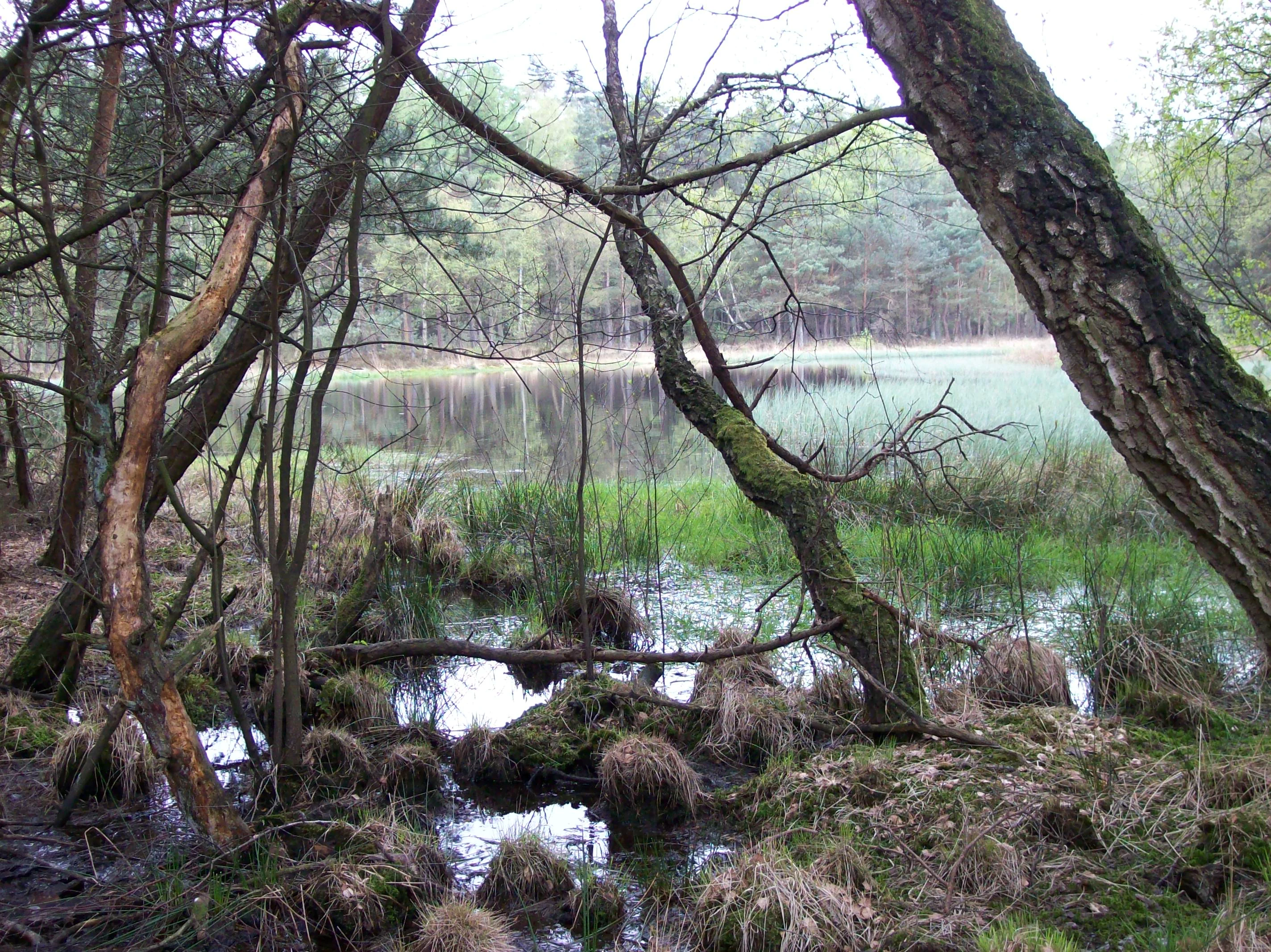
A view through trees into a small, reflective pond surrounded by a marshy forest landscape in Lower Saxony, Germany.
The heath pond at Swatte Poele nature reserve.

Swatte Poele history and protected-area timeline

The protected history of Swatte Poele begins earlier than the reserve itself, with the designation of the Röthekuhle site as a Naturdenkmal on 20 January 1970. This earlier recognition marked the first formal protection of part of the now-familiar heath-pond landscape and laid the groundwork for a larger designation.

On 1 August 1976, the area was formally established as the Naturschutzgebiet Swatte Poele under the reference code NSG WE 051. The expanded reserve absorbed the older Röthekuhle monument and pulled the surrounding heath, mire, and forest mosaic into a single protected entity. The Osnabrück district serves as the responsible lower nature protection authority, while the NLWKN provides state-level oversight.

In parallel, the area has been recognized as a FFH (Flora-Fauna-Habitat) site under the European Union's Habitats Directive, with the protected boundaries of the FFH area nearly identical to those of the national nature reserve. This dual designation reflects a conservation trajectory that started with a small local protection of a remarkable pond basin and broadened into a more regionally and internationally anchored framework.

Swatte Poele landscape and geographic character

Swatte Poele sits along the margin of the Fensterberge end moraine, a low ridge of glacial deposits that gives the wider landscape its gently rolling profile. The reserve itself occupies some of the lowest ground here, with elevations clustered between roughly 42 and 43 meters above sea level, and uses the slope-to-flat transition to layer several distinct landscape types within a very small footprint.

The most striking element is the trio of heath ponds, shallow water bodies set into slight depressions and fringed by floating and quaking mire. These ponds are gradually silting up, producing a moving shoreline of bog mats, sedge stands, and encroaching wet woodland. Beyond them, the terrain lifts gently into belts of wet and dry heath, then into pine-dominated forest on the driest sandy rises.

The visual impression is one of tightly packed contrasts: open reflective water, dark mats of Sphagnum, pale drifts of cotton grass, earthy heather, and the darker green of pine and birch. Scattered junipers add small punctuation marks, calling back to a more open, grazed past. Around the reserve, the surrounding countryside continues the same mix, with forest as the dominant matrix and farmland appearing in patches.

Swatte Poele ecosystems, habitats, and plant life

The ecological character of Swatte Poele is defined by overlapping gradients of moisture, soil chemistry, and historical land use. At its center lies a system of open water and mire, where peat mosses, white beak-sedge, bog asphodel, sundews, crowberry, and marsh clubmoss form a rare assemblage characteristic of northwest German heath-pond complexes.

Just beyond the water's edge, transitional habitats take over. Floating sweet-grass, common soft-rush, bulbous rush, beaked sedge, and marsh horsetail create a zone of tall sedges and reeds, while species like frogbit, small bladderwort, and white water lily thrive in the open water. Further outward, the ground rises into wet heaths populated by bell heather and common heather, with scattered patches of moorgrass interrupting the heather carpet under more acidic conditions.

On the slightly elevated sandy soils, planted pine forests dominate, with birch-pine bog woodland occupying parts of the wetter transition zones. A few surviving junipers reflect the reserve's earlier character as a grazed heath, hinting at how the open vegetation was once maintained. The result is a habitat mosaic compressed into a few hectares, where each vegetation type remains identifiable because the underlying topography and soils change so rapidly across such a short distance.

Swatte Poele wildlife and species highlights

Although the source material does not catalogue specific animal species in detail, the habitats present at Swatte Poele are known to support characteristic fauna of northwest German heath-pond landscapes. The open water and sedge fringes provide conditions favored by amphibians, dragonflies, and other wetland invertebrates that depend on acidic, fish-poor pools.

The surrounding heath, mire edges, and adjacent pine and birch woodland offer cover and foraging opportunities for typical birdlife of the Lower Saxon sand country, including heathland and bog specialists. The mix of wet core and dry forest edge allows both water-associated and woodland species to find usable habitat within a very small area, which is one of the key ecological roles the reserve plays in the region.

Swatte Poele conservation status and protection priorities

Swatte Poele's conservation importance rests on the fact that it unites several now-rare habitats into a single protected site. The combination of heath ponds, quaking bogs, wet and dry heaths, juniper relict grassland, bog woodland, and pine forest represents a working example of the Pleistocene sand landscape that once dominated much of northwestern Germany.

The site's recognition as both a Naturschutzgebiet under German law and an FFH area under the European Union's Habitats Directive places it inside the Natura 2000 network. That dual designation reflects the ecological value beyond purely national interest: heath ponds and their fringing mires are priority habitat types whose long-term survival depends on small, well-managed refuges like this one.

The reserve protects a landscape that is otherwise vulnerable to drainage, agricultural intensification, conifer planting, and succession into closed forest. By maintaining the heath-pond mosaic in its current suppressed or slowly evolving state, Swatte Poele helps anchor broader regional efforts to keep representative examples of these habitats viable for the future.

Swatte Poele cultural meaning and human context

The presence of scattered junipers in the reserve is a quiet reminder of the area's earlier pastoral history. Before protection, the heath landscape around the ponds was kept open by grazing livestock, and these junipers are living remnants of that open, semi-cultural phase.

More broadly, the reserve belongs to a region whose identity has long been shaped by the interplay of glacial geology, heath, and human use of sandy, less productive soils. Theauction of heath, mire, and pine woodland that makes up Swatte Poele echoes the wider landscape of the Osnabrück district and northern Lower Saxony, where small nature reserves are scattered among forests and farmland rather than concentrated in a single iconic zone.

Top sights and standout views in Swatte Poele

Three heath ponds and their fringing mires form the centerpiece of Swatte Poele, supported by an unusually complete ring of wet and dry heath and pine forest within a 4.3 hectare footprint. The reserve is at the same time a German Naturschutzgebiet and a near-identical FFH area, linking local and European conservation frameworks.

Other highlights include the surviving junipers that recall the area's earlier grazed character and the integration of the older Röthekuhle natural monument into the broader reserve.

Best time to visit Swatte Poele

The character of Swatte Poele changes with the seasons in ways that mirror the rest of northwest Germany's heath landscapes. Late spring and summer bring the most active phase of flowering, with cotton grasses, heathers, and bog asphodel in bloom and dragonflies and amphibians at their most active around the ponds. Early autumn emphasizes the purple tones of the heaths and the russet colors of the bog vegetation, while winter offers a quieter view of the open water and the structural contrast between bare heath and dark pine forest.

Because the reserve is very small and primarily a protection-focused site with no developed visitor infrastructure described in the source material, visits are essentially low-impact observational stops rather than destination outings.

Monthly climate preview

Track monthly temperature ranges and precipitation averages across the park coordinate

Swatte Poele Climate Normals, Annual Temperature and Precipitation Rhythms

Historical data records mean temperatures ranging from 1.35 to 18.24 degrees Celsius alongside steady precipitation patterns throughout the year. Reviewing the comprehensive monthly profile clarifies long-term meteorological shifts for Swatte Poele.
Annual mean10 °C
1 °C18 °C
Jan
Feb
Mar
Apr
May13°
Jun16°
Jul18°
Aug18°
Sep14°
Oct10°
Nov
Dec
Warmest month
July

18.2 °C

Coolest month
January

1.4 °C

Wettest month
December

2.4 mm/day

Driest month
April

1.4 mm/day

Park location guide

Geography guide, regional context, and park location map for Swatte Poele

Swatte Poele park geography, regions, and map view in Germany

Understand where Swatte Poele sits in Germany through a broader geographic reading of the surrounding landscape, nearby location context, and its mapped position within the national park landscape.

How Swatte Poele fits into Germany

Germany is a federal republic in Western and Central Europe with a population of over 83 million across sixteen constituent states. It is Europe's largest economy by nominal GDP and a major global exporter and importer. The capital is Berlin, and the country borders Denmark, Poland, Czech Republic, Austria, Switzerland, France, Luxembourg, Belgium, and the Netherlands.

Wider geography shaping Swatte Poele in Germany

Germany is located in Western and Central Europe, spanning 357,022 km². It borders Denmark to the north, Poland and the Czech Republic to the east, Austria and Switzerland to the south, and France, Luxembourg, Belgium, and the Netherlands to the west. The country has coastlines on the Baltic Sea and North Sea to the north, with the Alps located in the southern region.

Map view of Swatte Poele

Use this park location map to pinpoint Swatte Poele in Germany, understand its exact geographic position, and read its mapped placement within the surrounding landscape more clearly.

Pigeon | © OpenStreetMap contributors

Location context for Swatte Poele

Landkreis OsnabrückLower Saxony
Recorded earthquake history

View the Swatte Poele Earthquake History and Seismic Catalogue

Examine the historical record of seismic activity documented near the Swatte Poele nature reserve. This catalogue from MoriAtlas presents associated earthquake data, offering a transparent view of recorded seismic events within the regional geography of the Osnabrück district.

Swatte Poele Earthquake History

Catalogued events

10 events

Strongest magnitude

Magnitude 4.7

Most recent event

Jul 18, 2008

This history includes earthquakes recorded inside the park or within 50 km of its borders

Explore protected area photography capturing rare mire vegetation and end moraine terrain.

Swatte Poele Photos and Landscape Scenery: Visualizing Glacial Ponds and Heathland Habitats

Visual documentation reveals the intricate mosaic of shallow heath ponds, quaking bogs, and pine woodlands defining the protected reserve. Examining these landscape views clarifies the unique ecological structure shaped by Pleistocene glaciation along the end moraine ridge.

A view through trees into a small, reflective pond surrounded by a marshy forest landscape in Lower Saxony, Germany.

Park atlas

Compare surrounding glacial landscapes and connected northern German nature reserves.

Explore Parks Near Swatte Poele and Related Protected Areas in the Region

Browse other parks near Swatte Poele to examine similar heath ponds, glacial moraines, and wetland habitats across the wider regional landscape. Comparing adjacent protected areas reveals the broader ecological patterns of the northwest German sandlands.
A soft watercolor painting of a rolling landscape with green fields, scattered evergreen and deciduous trees, and distant hills under a light sky.
Nature reserveNorth Rhine-Westphalia
12 km away#1 closest

South

Koffituten Nature Reserve and the Protected Bog Landscapes of North Rhine-Westphalia

A study of raised bog regeneration and inland dune ecosystems.

Koffituten provides a clear look at bog restoration and land management within the Steinfurt district. This nature reserve protects a rare raised bog island alongside a mix of pine-oak forest, fen woodland, and inland dunes. Its compact size and historical restoration work make it a focal point for understanding the interplay between wetland and dry-land habitats in the German lowlands.

Area
0.236 km²
Established
1991
Relief
Lowland
Climate
Temperate
Nature reserveLandkreis Osnabrück
About 14 km away#2 closest

Northeast

Suddenmoor Nature Reserve: Mapped Protected Landscapes in Landkreis Osnabrück

Lowland peatland habitats and regional German geography

Suddenmoor serves as a crucial nature reserve in Landkreis Osnabrück, characterized by its flat, peat-rich soil and dense network of drainage channels. The reserve preserves an authentic Artland landscape, featuring a rare combination of wet meadow ecosystems and traditional Wallhecken field boundaries. This protected area stands as a vital connector between larger wetland complexes in the northern German lowland terrain.

Area
3.11 km²
Established
2018
Relief
Lowland
Climate
Temperate
Nature reserveEmsland
About 18 km away#3 closest

North

Zitterteiche Nature Reserve in Emsland: Mapped Protected Landscapes and Geography

A study of lowland heath ponds and environmental history

Zitterteiche represents a specific, small-scale nature reserve in the Emsland of Germany, consisting of two shallow heath ponds defined by their surrounding agricultural plains. This detailed entry maps the physical terrain and ecological shift of these protected waters, offering a focused perspective on the regional geography and the historical trajectory of this unique, formally protected wetland area.

Area
0.029 km²
Established
1937
IUCN
IV
Relief
Lowland
Nature reserveLower Saxony
About 25 km away#4 closest

Northwest

Südtannenmoor Nature Reserve in Lower Saxony: An Atlas of Protected Bog Wetlands

Mapping rare heath pool ecosystems in the Emsland region

This nature reserve protects a fragile intersection of raised-bog remnants and shallow heath pools framed by coniferous forests. The site serves as a key reference for the restoration of specialized wetland vegetation in northwestern Germany, offering a clear view of how small-scale geography influences biodiversity in the Emsland landscape.

Area
0.049 km²
Established
2009
IUCN
IV
Relief
Lowland
A watercolor painting of a soft landscape featuring rolling hills and forested areas under a light pink and yellow sky.
Nature reserveNorth Rhine-Westphalia
About 30 km away#5 closest

South

Moßmörken Nature Reserve: Regional Protected Area and Geographic Atlas Entry

Inland dune and bog landscape in North Rhine-Westphalia, Germany

Moßmörken provides a concentrated study of regional geology and conservation through its varied mosaic of wet grassland, nutrient-poor aquatic habitats, and remnant dunes. As a protected area in the North Rhine-Westphalia region, it represents an essential site for understanding the interplay between post-glacial land-forming processes and local habitat succession in western Germany.

Area
0.129 km²
Established
1995
IUCN
IV
Relief
Lowland
Nature reserveNordrhein-Westfalen
32 km away#6 closest

South

Zachhorn Nature Reserve: Protected Heathland and Wetland Landscapes in Nordrhein-Westfalen

Geographic atlas of the Ems valley heathland pond refuge.

Zachhorn is a defined nature reserve in the Steinfurt district, protecting two shallow ponds and surrounding acidic heathland characteristic of the Ems valley lowlands. This site provides a rare, nutrient-poor aquatic environment that supports specialized wetland flora and essential amphibian habitats, forming a distinct piece of the regional conservation mosaic in Nordrhein-Westfalen.

Area
0.214 km²
Established
1990
IUCN
IV
Protected landscapeEmsland
About 34 km away#7 closest

North

Naturpark Hümmling: Geographic Overview of Emsland Protected Landscapes

Tracing glacial sand ridges, moorlands, and prehistoric cultural sites.

Naturpark Hümmling stands as a prominent protected landscape in Lower Saxony, characterized by its distinctive geest ridge, extensive raised bogs, and dense concentration of Neolithic stone monuments. The area map highlights a complex interplay of river valleys, heathland remnants, and historic cultural landmarks that define the geographical identity of this Emsland treasure.

Area
576 km²
Established
2015
Relief
Upland
Climate
Temperate
Nature reserveEmsland
About 38 km away#8 closest

Northwest

Versener Heidesee Nature Reserve: Mapped Protected Areas in Emsland, Lower Saxony

Heathland habitats and aquatic ecosystems in the Bourtanger Moor region

Versener Heidesee represents a significant example of post-industrial landscape reclamation, where a motorway extraction site was transformed into a protected nature reserve. The site spans 40 hectares, featuring a 16-hectare lake and managed heathland that sustains rare algae species and diverse avian populations. Its location within the International Nature Park Bourtanger Moor-Bargerveen highlights the importance of small-scale, managed terrain for regional ecological health.

Area
0.4 km²
Established
2008
Relief
Lowland
Climate
Temperate

Common questions about visiting, size, designation, and location context for Swatte Poele

Swatte Poele FAQs for park facts, access, geography, and protected area context

Find quick answers about Swatte Poele, including protected-area facts, park geography, trail and visitor context, and how the park fits into its surrounding country and regional landscape.
MoriAtlas Explorer

Continue Your Protected Areas Search Across the Global Atlas

Deepen your exploration by continuing the structured search for national parks and protected areas worldwide. Utilize the comprehensive filtering capabilities to compare different conservation landscapes and refine your understanding of global park geography. Discover more about the distribution and characteristics of protected natural areas.

Global natural geography