Mori Atlas logo
Nature reserveTäler der Ill und ihrer Nebenbäche

Understanding the mapped landscape of the Ill drainage system and its riparian corridors.

Täler der Ill und ihrer Nebenbäche: A Protected River Valley Network in Saarland, Germany

(Naturschutzgebiet Täler der Ill und ihrer Nebenbäche)

Täler der Ill und ihrer Nebenbäche forms a significant nature reserve in the Saarland hill country, spanning multiple districts across Neunkirchen and St. Wendel. This protected area follows the dendritic drainage pattern of the Ill river, conserving a connected mosaic of stream-valley habitats. The reserve demonstrates the integration of ecological protection within a region defined by complex infrastructure, offering a clear view of how riparian zones shape the local topography.

river valleystream valleysIll riverriparian habitathabitat managementNaturschutzgebiet

Täler der Ill und ihrer Nebenbäche

Nature reserve

Park overview

Structured park overview, official facts, and landscape profile for Täler der Ill und ihrer Nebenbäche

Täler der Ill und ihrer Nebenbäche park facts, protected area profile, and essential visitor context

Review the core facts for Täler der Ill und ihrer Nebenbäche, including designation, size, terrain, visitor scale, habitats, and operating context in one park-focused overview.

About Täler der Ill und ihrer Nebenbäche

Täler der Ill und ihrer Nebenbäche is one of the formally designated nature reserves of Saarland, a small southwestern German state bordering France and Luxembourg. The reserve's identity is tied to the Ill, a regional river whose headwaters and middle reaches cut through the gently rolling hill country of central Saarland. By protecting the valleys of the Ill and its tributary streams, the reserve targets exactly those low-lying, water-rich zones that are otherwise vulnerable to agricultural intensification, settlement expansion, and infrastructure development.

Geographically, the reserve spans parts of two administrative districts: Landkreis Neunkirchen to the west and Landkreis St. Wendel to the east. It sits between the main towns of Lebach and St. Wendel, with the settlements of Alsweiler, Marpingen, Illingen, and Eppelborn located within or adjacent to the protected area. This positioning reflects the way the Ill and its tributaries weave between these communities, and why the protected area takes the form of many separate parcels rather than a single bordered block.

The reserve is legally anchored in a 2005 ordinance and carries the identifier NSG-104, with international recognition through the World Database on Protected Areas under WDPA-ID 319195. It is classified as IUCN Category IV, a designation used for areas where the primary conservation goal is the management of particular habitats or species, often alongside a working landscape. The presence of major transport corridors such as the A1 motorway, the B269 federal road, and several Landesstraßen crossing the area also shapes how the protected landscape is configured: the Ill valley system threads between and around these infrastructure lines.

For Saarland, a state with limited high-mountain or coastal terrain, river-valley reserves like this one carry particular importance. They preserve the ecological backbone of the state's hydrology, including stream morphology, riparian vegetation, and the habitat networks that depend on flowing water. The reserve's fragmented but valley-following design makes it a representative example of how conservation planning responds to a landscape where natural corridors align closely with human settlement and transport routes.

Quick facts and research context for Täler der Ill und ihrer Nebenbäche

Täler der Ill und ihrer Nebenbäche is a designated Naturschutzgebiet in Saarland, Germany, located in the Landkreise (districts) of Neunkirchen and St. Wendel. It was formally established by ordinance on 1 February 2005 under the official reference number NSG-104. The reserve comprises many separate component parcels that together extend east of Lebach and west and southwest of St. Wendel, encompassing parts of the municipalities of Alsweiler, Marpingen, Illingen, and Eppelborn.

Internationally, it is recorded in the World Database on Protected Areas under WDPA-ID 319195 and is categorized as IUCN Category IV, indicating a focus on habitat and species management. The Ill and its tributaries define the protected landscape, with the reserve acting as a network of valley habitats rather than a single large contiguous unit.

Protection and recognition

Examine documented protected area records, management scope, and official designation data.

Täler der Ill und ihrer Nebenbäche Protection Status and International Recognition

Examine documented protection status, management scope, and official registry records associated with Täler der Ill und ihrer Nebenbäche. Review structured conservation data and international source records for this protected area within the global atlas.

Protection details

WDPA ID
319195
Park context

Deeper park guide and search-rich context for Täler der Ill und ihrer Nebenbäche

Täler der Ill und ihrer Nebenbäche history, landscape, wildlife, and travel context

Explore Täler der Ill und ihrer Nebenbäche through its history, landscape character, ecosystems, wildlife, conservation priorities, cultural context, and seasonal travel timing in a structured park guide built for atlas discovery and search intent.

Why Täler der Ill und ihrer Nebenbäche stands out

The reserve is best known for protecting the valley corridors of the Ill river and its tributary streams in central Saarland. Its defining feature is a network of stream-valley habitats that follow the dendritic pattern of the Ill drainage, creating a mosaic of riparian environments across multiple component areas. Rather than being defined by a single dramatic landscape, the area's significance lies in the ecological value of low- and mid-elevation river valleys typical of the Saarland hill country. These valleys support characteristic wetland vegetation, beaver activity along tributaries, and habitat continuity that is valuable for aquatic and riparian species in a landscape otherwise shaped by roads and settlements.
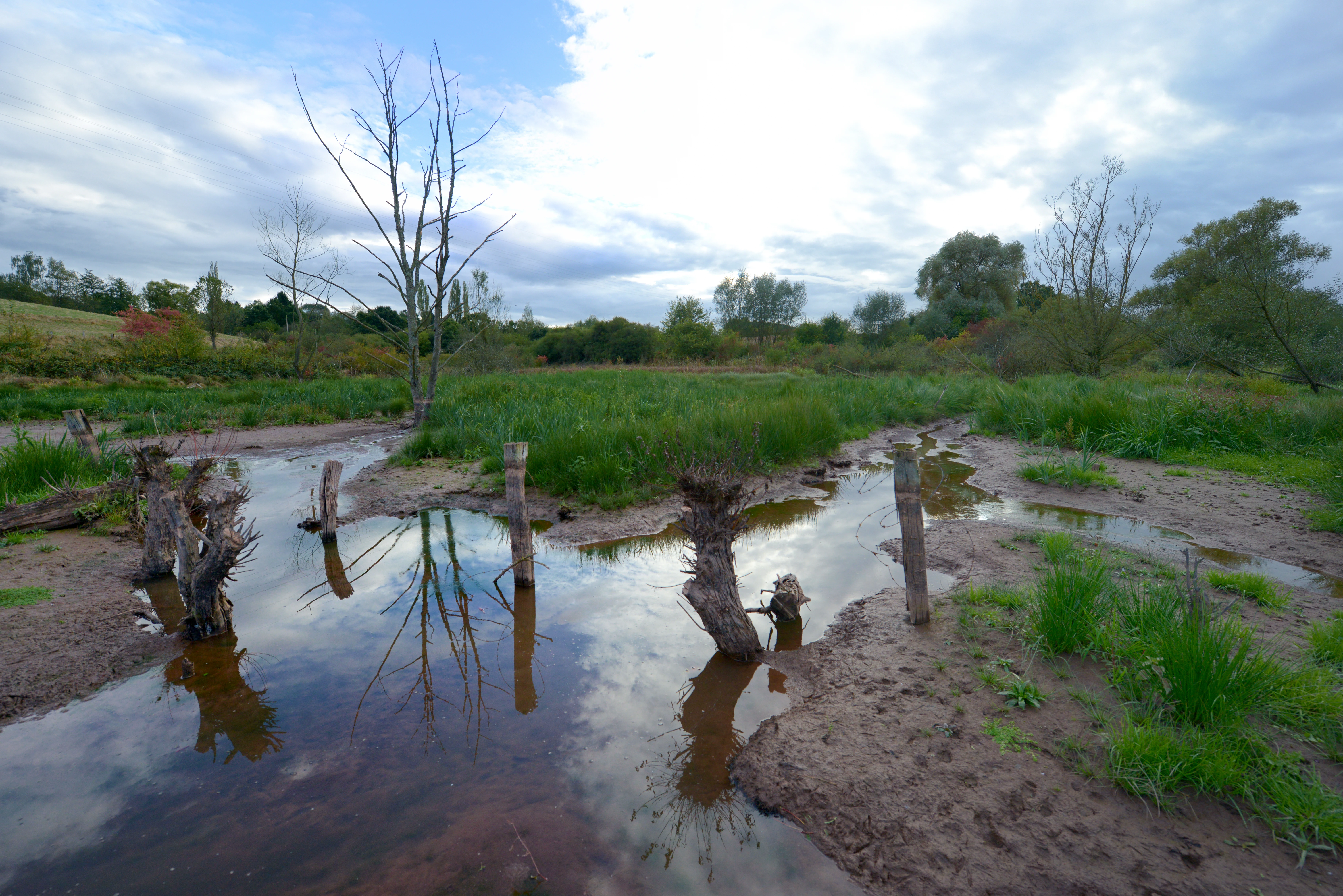
A muddy wetland area featuring a series of gnawed tree stumps standing in shallow water, indicative of beaver activity, with green grass and trees in the background under a cloudy sky.
A beaver dam site at the confluence of the Malzbach and Mettelbach in the Täler der Ill und ihrer Nebenbäche nature reserve.

Täler der Ill und ihrer Nebenbäche history and protected-area timeline

The reserve was established by official ordinance on 1 February 2005, formalizing the protected status of the Ill valley and its tributary streams under German nature conservation law. The designation NSG-104 was assigned as the reserve's official reference number within the Saarland system of Naturschutzgebiete.

The placement of legal protection on this date reflects a more systematic effort in late 20th and early 21st century Germany to codify and expand a network of nature reserves at the district level. By selecting the Ill and its tributaries for designation, Saarland authorities recognized the ecological importance of stream-valley habitats that had previously lacked formal protective status. The 2005 ordinance remains the foundational legal act for the reserve's current identity.

No major subsequent redesignation or boundary restructuring is documented in the available source material, and the reserve's present-day definition continues to follow the structure laid out in the founding ordinance.

Täler der Ill und ihrer Nebenbäche landscape and geographic character

The landscape defined by Täler der Ill und ihrer Nebenbäche is the river-valley system of the Ill and its tributary streams in central Saarland. The terrain belongs to the Saarland hill country, characterized by moderate elevations, rounded ridges, and incised stream valleys that open into broader low-lying corridors where the main Ill watercourse runs.

Because the reserve is structured as multiple component areas rather than one contiguous block, the protected landscape reads as a chain of valleys following the Ill drainage network. The streams cut between settlements and across the interfluves, creating a patchwork of valley habitats, slopes, ridge edges, and small floodplain-like zones. Locally the topography is shaped by the gentle relief typical of the region, with the Ill and its tributaries acting as the organizing feature for the surrounding land.

The protected area is bordered and intersected by significant transport infrastructure, including the A1 motorway, the B269 federal road, and the Landesstraßen L 33, L 112, and L 299, with the A8 running close to its southern side. These corridors cross the valleys and frame the reserve's fragmented configuration, while the underlying landscape remains defined by the natural hydrology of the Ill system.

Täler der Ill und ihrer Nebenbäche ecosystems, habitats, and plant life

The ecological identity of the reserve centers on the stream and river habitats of the Ill and its tributaries. These valleys support the characteristic vegetation zonation of central European low- to mid-elevation river systems, with riparian woodland, wet meadows, and stream-side shrubs lining the watercourses, and more mesic forest communities occupying the valley slopes and adjoining hill areas.

Because the reserve is structured around the Ill drainage network, the protected landscape functions ecologically less as a single block and more as a connected corridor system. Stream margins, small flood-prone flats, wet thickets, and the transition zones between water and slope form the core of the habitat network. The mosaic character of these valley habitats is particularly valuable in a region where agricultural land use and settlement dominate the broader matrix.

The protected area's IUCN Category IV status underscores that management is focused on the conservation of these specific habitat and species assemblages. While fine-grained habitat inventories are not detailed in the available source material, the reserve clearly fits within the broader pattern of Saarland nature conservation, where protecting hydrological systems and their associated riparian habitats is a recurring priority.

Täler der Ill und ihrer Nebenbäche wildlife and species highlights

The wildlife significance of the reserve is closely linked to its character as a network of stream valleys. Beaver activity along tributaries, including visible dam-building in smaller side streams, is part of the area's ecological identity, indicating functioning riparian processes that support semi-aquatic mammals. Such activity is a hallmark of healthy low-elevation stream systems in central Europe.

Riparian habitats along the Ill and its tributaries create conditions favorable for a range of typical stream-associated fauna, including amphibians, aquatic invertebrates, and fish adapted to small to medium-sized lowland rivers. The continuity of vegetated stream margins also supports bird communities associated with mixed woodland edges, wet thickets, and watercourses.

The reserve's role for wildlife is best understood not through any single flagship species but through the maintenance of habitat conditions that allow a typical Saarland stream-valley fauna to persist in a landscape otherwise shaped by roads, farmland, and villages. No detailed species inventories are provided in the available source material.

Täler der Ill und ihrer Nebenbäche conservation status and protection priorities

The conservation significance of Täler der Ill und ihrer Nebenbäche lies in its formal protection of a stream-valley network that would otherwise be vulnerable to ongoing land-use pressures in central Saarland. By legally binding the valleys of the Ill and its tributaries under a 2005 ordinance, the reserve secures a set of habitats that are disproportionately important for regional biodiversity relative to the amount of land they cover.

The reserve's IUCN Category IV classification identifies it as a Habitat and Species Management Area, a designation used when the primary objective is to maintain, restore, or improve particular habitats and the species they support. This framing emphasizes active management of the valley corridors rather than purely passive protection, recognizing that stream habitats benefit from ongoing intervention to retain their ecological structure.

Inclusion in the World Database on Protected Areas under WDPA-ID 319195 places the reserve within the international inventory of formally recognized protected sites, giving it standing beyond the regional Saarland context. Within Saarland itself, the reserve is part of the broader network of Naturschutzgebiete in the Landkreise of Neunkirchen and St. Wendel, contributing to habitat connectivity across the central part of the state.

Täler der Ill und ihrer Nebenbäche cultural meaning and human context

The reserve's cultural context is tied to the rural and small-town landscape of central Saarland. The protected valleys sit within a region historically shaped by agriculture, small forest holdings, and dispersed villages such as Alsweiler, Marpingen, Illingen, and Eppelborn. The Ill and its tributaries have long been part of the local landscape identity, both as practical resources and as features defining parish and municipal boundaries.

The presence of federal and state roads crossing the area, including the A1 and A8 motorways, reflects the broader role the region plays as a transit landscape within Saarland and toward neighboring Rhineland-Palatinate and France. The coexistence of transport corridors, villages, and protected valley habitats illustrates the working-landscape character of conservation in this part of Germany.

No deeper indigenous or traditional-use context is documented in the available source material, and any broader cultural framing should be considered in light of the standard rural Saarland settlement pattern rather than a distinct local heritage narrative.

Top sights and standout views in Täler der Ill und ihrer Nebenbäche

Täler der Ill und ihrer Nebenbäche stands out for offering a protected network of river-valley habitats that thread through the densely settled and infrastructure-rich central Saarland. Its component-area structure follows the Ill and its tributaries closely, allowing conservation efforts to align with the natural geometry of the drainage system rather than with arbitrary property or administrative boundaries.

The reserve also illustrates how formal nature protection functions in a working German landscape. Major roads and motorways cross the area, and yet the core valleys of the Ill and its tributaries remain under binding legal protection, demonstrating the integration of ecological priorities into a regional land-use mosaic.

Best time to visit Täler der Ill und ihrer Nebenbäche

The reserve's stream-valley character is most accessible in seasons when water levels are visible and riparian vegetation is in active growth. Late spring through early autumn tends to favor the observation of green vegetation along tributaries and beaver-modified sections of streams, while winter and early spring can offer clearer views of valley structure when leaf cover is reduced.

As a Naturschutzgebiet, any visit should respect the general access rules that apply to formally protected areas in Germany, including staying on marked paths and avoiding disturbance to wildlife and habitats. Detailed seasonal access or visitor-program information is not provided in the available source material.


Monthly climate preview

Long-term representative temperature and precipitation measurements across the protected landscape

Täler der Ill und ihrer Nebenbäche Climate Normals and Monthly Weather Patterns

Representative coordinates record measured temperature ranges and steady precipitation cycles throughout the year at Täler der Ill und ihrer Nebenbäche. Reviewing the comprehensive monthly climate records provides deeper context regarding long-term environmental averages across the protected terrain.
Annual mean9 °C
0 °C19 °C
Jan
Feb
Mar
Apr
May12°
Jun16°
Jul19°
Aug18°
Sep14°
Oct
Nov
Dec
Warmest month
July

18.6 °C

Coolest month
January

-0.2 °C

Wettest month
December

2.9 mm/day

Driest month
April

1.7 mm/day

Park location guide

Geography guide, regional context, and park location map for Täler der Ill und ihrer Nebenbäche

Täler der Ill und ihrer Nebenbäche park geography, regions, and map view in Germany

Understand where Täler der Ill und ihrer Nebenbäche sits in Germany through a broader geographic reading of the surrounding landscape, nearby location context, and its mapped position within the national park landscape.

How Täler der Ill und ihrer Nebenbäche fits into Germany

Germany is a federal republic in Western and Central Europe with a population of over 83 million across sixteen constituent states. It is Europe's largest economy by nominal GDP and a major global exporter and importer. The capital is Berlin, and the country borders Denmark, Poland, Czech Republic, Austria, Switzerland, France, Luxembourg, Belgium, and the Netherlands.

Wider geography shaping Täler der Ill und ihrer Nebenbäche in Germany

Germany is located in Western and Central Europe, spanning 357,022 km². It borders Denmark to the north, Poland and the Czech Republic to the east, Austria and Switzerland to the south, and France, Luxembourg, Belgium, and the Netherlands to the west. The country has coastlines on the Baltic Sea and North Sea to the north, with the Alps located in the southern region.

Map view of Täler der Ill und ihrer Nebenbäche

Use this park location map to pinpoint Täler der Ill und ihrer Nebenbäche in Germany, understand its exact geographic position, and read its mapped placement within the surrounding landscape more clearly.

Pigeon | © OpenStreetMap contributors

Location context for Täler der Ill und ihrer Nebenbäche

Saarland

Visualizing river valley habitats, stream terrain, and protected landscapes

Täler der Ill und ihrer Nebenbäche Photos and Landscape Scenery

Visual records reveal the intricate stream networks, valley floors, and riparian habitats that define Täler der Ill und ihrer Nebenbäche across its fragmented reserve areas. Studying these protected landscapes provides clear insight into the riverine topography and conservation character of the Saarland hill country.

A muddy wetland area featuring a series of gnawed tree stumps standing in shallow water, indicative of beaver activity, with green grass and trees in the background under a cloudy sky.

Park atlas

Compare surrounding valley landscapes and regional nature reserves

Explore Protected Areas and Parks Near Täler der Ill und ihrer Nebenbäche

Browse nearby protected landscapes and stream valley reserves that share the regional geography of central Saarland. Expanding the search helps compare adjacent riparian habitats and connected natural corridors beyond Täler der Ill und ihrer Nebenbäche.
Nature reserveSaarland
About 13 km away#1 closest

Northwest

Wiesenlandschaft bei Überroth: Nature Reserve Geography and Mapped Meadow Habitats

Essential protected land analysis in the Saarland region of Germany

Wiesenlandschaft bei Überroth functions as a core protected area for species-rich meadows in southwestern Germany. This detailed entry maps its two-part configuration and explains its role within the regional Saarland habitat network, providing a clear geographic perspective on its conservation status and semi-natural terrain characteristics.

Area
2.87 km²
Established
2015
IUCN
IV
Relief
Lowland
Nature reserveSaarland
About 13 km away#2 closest

North

Südteil des Nohfeldener Rhyolith-Massivs: Saarland Nature Reserve and Volcanic Highland Terrain

Protected montane grasslands and rare bog woodland habitats.

This nature reserve protects 73 hectares of critical habitat within the Saarland uplands. Defined by the rhyolite massif geology between Losenberg and Leißberg, the protected area maintains rare montane mat-grass swards and fragile bryophyte communities. The site serves as a vital example of volcanic landscape conservation, highlighting the intersection of acidic silicate soils and specific ecological biodiversity in Germany.

Area
0.73 km²
Established
2017
IUCN
IV
Nature reserveGermany
About 17 km away#3 closest

Southeast

Taubental Nature Reserve: Protected Landscape and Forest Geography in Germany

Core zone forest conservation in the Saarpfalz district.

Taubental Nature Reserve protects a continuous stretch of mixed broadleaf and coniferous forest situated on the Buntsandstone ridges of southwestern Germany. As a core zone within the Bliesgau Biosphere, it maintains essential habitat connectivity despite its proximity to major regional infrastructure, providing a unique case study in forest preservation within the Saarpfalz-Kreis landscape.

Area
4.26 km²
Established
2007
A soft, artistic watercolor painting showing a wide, tranquil wetland scene with soft green and yellow hues, distant rolling hills, and patches of trees and vegetation in a floodplain environment.
Protected landscapeSaarland
About 18 km away#4 closest

Southeast

Beeder Bruch Protected Landscape: Blies River Floodplain and Wetland Geography in Saarland

A managed riverine sanctuary in the Bliesgau Biosphere Reserve

Beeder Bruch is a formally recognized protected landscape in Saarland, defined by the extensive floodplain of the Blies river. The site integrates wet meadows, riparian forests, and reedbeds, serving as a key European bird protection zone. Visitors can explore the mapped terrain, which utilizes conservation grazing to maintain essential wetland habitats and support local biodiversity within the Bliesgau region.

Area
127 km²
Established
2015
IUCN
V
Nature reserveRhineland-Palatinate
About 21 km away#5 closest

East

Westricher Moorniederung Nature Reserve: Protected Wetland and Moorland Atlas

Mapping low-lying basin landscapes and riparian corridors in the German Palatinate.

Spanning 40 kilometers between the Bliesaue and Kaiserslautern, the Westricher Moorniederung protects an intricate network of bogs, marsh zones, and alluvial forests. This lowland basin acts as a vital ecological link within Rhineland-Palatinate, defined by its drainage systems and diverse mire habitats. Gain insight into the regional geography and protected land boundaries that define this significant wetland system.

Area
21.52 km²
Established
1998
IUCN
IV
Nature reserveSaarland
About 21 km away#6 closest

Northwest

Wadrilltal Nature Reserve: Geographic Context and Mapped Protected Landscapes in Saarland

A protected stream valley habitat in the Hochwald region of Germany.

Wadrilltal represents a crucial nature reserve that shelters a near-natural stream valley system within the Saarland municipality of Wadern. The area preserves a structural diversity of wet meadows, montane mat-grass swards, and floodplain forests that form part of the Natura 2000 network. Gain geographic insight into the valley's slopes and river corridor, which extend across state boundaries to maintain significant regional biodiversity.

Area
1.67 km²
Established
2016
Scope
Terrestrial
Water
Major water bodies
Nature reserveSaarland
About 22 km away#7 closest

South

Wusterhang und Beierwies bei Fechingen: Protected Nature Reserve and Habitat Map

A study of calcareous beech forests and meadow geography in Saarland

Wusterhang und Beierwies bei Fechingen is a specialized nature reserve that captures the essential habitat diversity of the Saarland region. The area is defined by its small-scale mosaic of woodruff beech forest, orchid-rich calcareous slopes, and nutrient-poor grasslands. By examining this protected site, you can better understand the intersection of forest and meadow ecosystems that define this specific part of southwestern German geography.

A soft watercolor illustration depicting a river flowing through a lush green floodplain with trees, grasses, and a hazy background.
Nature reserveSaarland
About 22 km away#8 closest

Southeast

Bliesaue zwischen Blieskastel und Bliesdalheim Nature Reserve and Regional Landscape Geography

Protected floodplain ecosystems in Saarland, Germany

The Bliesaue zwischen Blieskastel und Bliesdalheim protects a near-natural river course and its surrounding floodplain in the Saarland region. The reserve is characterized by complex soil conditions from Buntsandstein and Muschelkalk substrates, supporting a rich network of wetlands, marshes, and meadows that function as a cohesive ecological unit for migratory birds and protected species.

Area
1.981 km²
Established
2015
Relief
Lowland
Climate
Temperate

Common questions about visiting, size, designation, and location context for Täler der Ill und ihrer Nebenbäche

Täler der Ill und ihrer Nebenbäche FAQs for park facts, access, geography, and protected area context

Find quick answers about Täler der Ill und ihrer Nebenbäche, including protected-area facts, park geography, trail and visitor context, and how the park fits into its surrounding country and regional landscape.
MoriAtlas Explorer

Continue Your Protected Areas Search Across the Global Atlas

Deepen your exploration by continuing the structured search for national parks and protected areas worldwide. Utilize the comprehensive filtering capabilities to compare different conservation landscapes and refine your understanding of global park geography. Discover more about the distribution and characteristics of protected natural areas.

Global natural geography