

Mori Atlas logo
Marine protected areaTañon Strait Protected Seascape

Explore the geographic boundaries, deepwater passages, and coastal landscape context of this vital Visayas marine sanctuary.

Tañon Strait Protected Seascape: Mapping the Largest Marine Protected Area in the Philippines

The Tañon Strait Protected Seascape encompasses over five thousand square kilometres of marine territory separating the islands of Negros and Cebu in the central Visayas. This extensive protected area functions as a critical transition zone between the Visayan and Bohol seas, featuring diverse coastal environments including mangroves, coral reefs, and dramatic underwater terrain that reaches depths of five hundred metres. Through precise mapping of these protected waters, researchers and enthusiasts gain a deeper understanding of its role as a essential habitat for cetaceans and other marine wildlife within the Philippine archipelago.

marine protected areaprotected seascapestraitvisayasphilippinescetaceans
A stylized flat illustration of a tropical coastal scene, showing mountains, a waterfall, and outrigger boats on the water.

Tañon Strait Protected Seascape

Marine protected area

Park overview

Structured park overview, official facts, and landscape profile for Tañon Strait Protected Seascape

Tañon Strait Protected Seascape park facts, protected area profile, and essential visitor context

Review the core facts for Tañon Strait Protected Seascape, including designation, size, terrain, visitor scale, habitats, and operating context in one park-focused overview.

About Tañon Strait Protected Seascape

The Tañon Strait Protected Seascape is a nationally significant marine conservation area in the central Philippines, protecting the deep, narrow waterway that separates the islands of Cebu and Negros. Designated in 1998, it encompasses more than 5,000 square kilometres of coastal and offshore waters and stands as the largest marine protected area in the Philippine protected area system. Its size and ecological richness place it among the most important marine conservation landscapes in the country.

Geographically, the strait functions as a crucial marine corridor linking the Visayan Sea to the north with the Bohol Sea (also known as the Mindanao Sea) to the south. Its long, relatively narrow shape, combined with a complex coastline, creates a diversity of coastal and pelagic habitats. The northern end of the strait is partially closed off by the Don Islands, including Bantayan Island, while deepwater port facilities at San Carlos on Negros Occidental, Bais on Negros Oriental, and Toledo on Cebu reflect the strait's importance for regional shipping and trade.

Ecologically, the protected seascape is most notable for its role in supporting marine mammals. Researchers and conservationists have documented eleven cetacean species using the strait, including baleen whales, toothed whales, dolphins, porpoises, and Irrawaddy dolphins. This concentration of cetacean diversity, combined with regular feeding and breeding activity, has made the strait an important site for marine wildlife tourism, particularly whale and dolphin watching tours operating from Bais.

The seascape has also been at the center of significant environmental policy debates. In 2008, the Supreme Court of the Philippines took up a petition asking the government to halt oil exploration by a foreign company in the protected waters. The case became notable for its argument that whales, dolphins, and porpoises in the strait should be recognized as 'Filipino mammals' with constitutional rights. The seascape has additionally been supported through international partnerships, including a UNDP-backed project on marine key biodiversity areas that ran from 2014 to 2020.

Culturally, the strait carries meaning beyond its ecological and political importance. In Cebuano mythology, the waters are woven into stories about the supreme god Kaptan and his winged messengers, and the strait is associated in local belief with sacred marine creatures and natural phenomena such as whirlpools. This blend of ecological importance, conservation history, and cultural significance gives the Tañon Strait Protected Seascape a distinctive identity within the Philippine protected area system.

Quick facts and research context for Tañon Strait Protected Seascape

The Tañon Strait Protected Seascape lies within the Visayas, the central island group of the Philippines, between the islands of Negros to the west and Cebu to the east. It was established as a Protected Seascape under Proclamation No. 1234 in 1998 by President Fidel V. Ramos, and is managed by the Department of Environment and Natural Resources (DENR). It is classified under IUCN Management Category V, reflecting its character as a protected landscape and seascape.

Covering more than 5,000 square kilometres, it is the largest marine protected area in the Philippines. The protected area encompasses not only the open waters of the strait but also significant coastal habitats along both Negros and Cebu, supporting fisheries, shipping, and growing marine wildlife tourism centered on cetaceans.

Protection and recognition

Examine the documented marine protection scope and formal designation details.

Tañon Strait Protected Seascape Protection Status and Recognition Data

Marine protection status and formal designation records outline the conservation framework established for Tañon Strait Protected Seascape. Structured documentation details management scope and administrative recognition parameters without assuming external frameworks.

Protection details

Protection scope
Marine
Transboundary protection
No
Park context

Deeper park guide and search-rich context for Tañon Strait Protected Seascape

Tañon Strait Protected Seascape history, landscape, wildlife, and travel context

Explore Tañon Strait Protected Seascape through its history, landscape character, ecosystems, wildlife, conservation priorities, cultural context, and seasonal travel timing in a structured park guide built for atlas discovery and search intent.

Why Tañon Strait Protected Seascape stands out

The Tañon Strait Protected Seascape is best known as the Philippines' largest marine protected area and as one of the country's most important habitats for cetaceans. The strait's waters are recognized as a critical breeding, feeding, and resting ground for at least eleven species of marine mammals, including baleen whales, toothed whales, dolphins, porpoises, and the increasingly rare Irrawaddy dolphin. It is also widely recognized as a center for whale and dolphin watching in the Visayas, with tour boats operating from Bais on the Negros Oriental coast. The protected seascape gained further national and international attention through a landmark Supreme Court case that sought to recognize cetaceans as 'Filipino mammals' with constitutional rights in order to halt oil exploration in the strait.
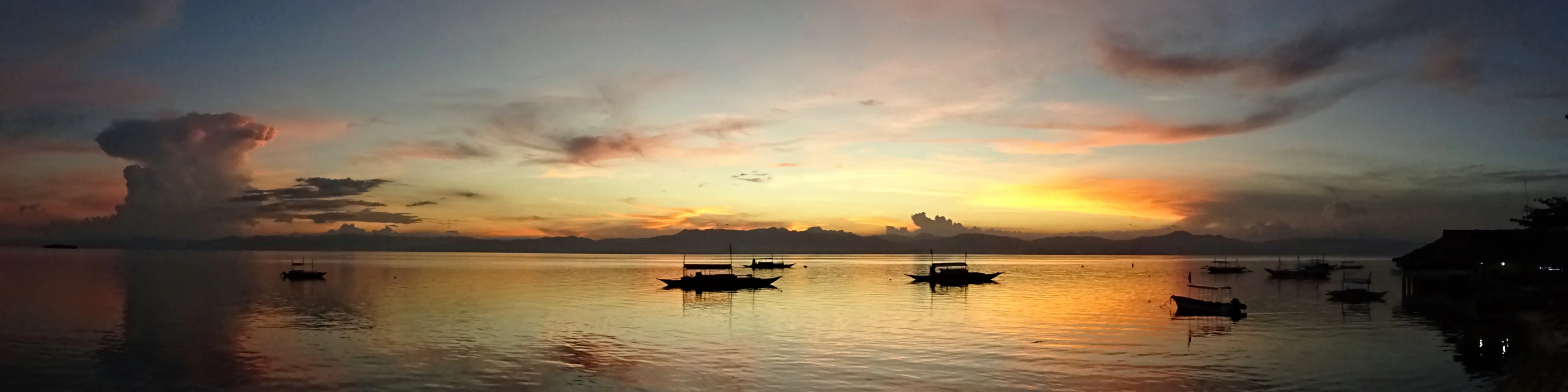
A wide panoramic view of a calm strait at sunset with small outrigger boats floating on the water, reflecting the orange and purple sky.
A sunset view over the waters of Tañon Strait, featuring local outrigger boats.

Tañon Strait Protected Seascape history and protected-area timeline

The Tañon Strait Protected Seascape was formally established in 1998 through Proclamation No. 1234, signed by President Fidel V. Ramos. The proclamation recognized the strait's ecological importance, particularly for marine mammals, and designated it as a Protected Seascape under the Philippine protected area framework, later aligned with IUCN Management Category V.

Following its establishment, the seascape became the focus of national efforts to strengthen marine biodiversity conservation. Between 2014 and 2020, it was included in the UNDP-funded project 'Strengthening the Marine Protected Area System to Conserve Marine Key Biodiversity Areas,' commonly referred to as Smart Seas Philippines, with Conservation International Philippines listed as a local partner.

The protected area also became the subject of major legal and political debate in 2008, when the Supreme Court of the Philippines ordered the Department of Environment and Natural Resources and the Department of Energy to respond to a petition seeking to stop oil exploration in the strait by a foreign petroleum company. The petition controversially argued that cetaceans inhabiting the strait should be recognized as 'Filipino mammals' with constitutional rights. While the company involved subsequently withdrew from exploration, citing non-commercial results, the legal proceedings continued as a significant precedent in Philippine environmental and animal rights jurisprudence.

Tañon Strait Protected Seascape landscape and geographic character

The Tañon Strait is a long, narrow marine passage running roughly north to south between the islands of Negros and Cebu in the central Visayas. Its total length is approximately 160 kilometres, and its width varies considerably, from about 27 kilometres in broader sections to as little as 5 kilometres at its narrowest southern reaches. Depths within the strait reach around 500 metres, giving it a substantial underwater profile that supports a range of marine environments.

At its northern end, the strait is partially enclosed by the Don Islands, of which Bantayan Island is the largest. This island grouping influences currents and water circulation within the strait. To the south, the passage opens broadly into the Bohol Sea, while the northern entrance connects to the Visayan Sea, positioning the strait as a key transition zone between two larger marine regions of the central Philippines.

The shoreline of the strait extends for several hundred kilometres and is highly varied. Both Negros and Cebu offer a mix of low-lying coastal plains, river mouths, mangrove areas, and stretches of cliffs and headlands. The surrounding topography on land includes mountainous areas of Cebu, from which viewpoints such as Osmeña Peak offer dramatic elevations above the strait, while the Negros coastline presents a blend of urban, agricultural, and natural coastal landscapes that frame the protected waters.
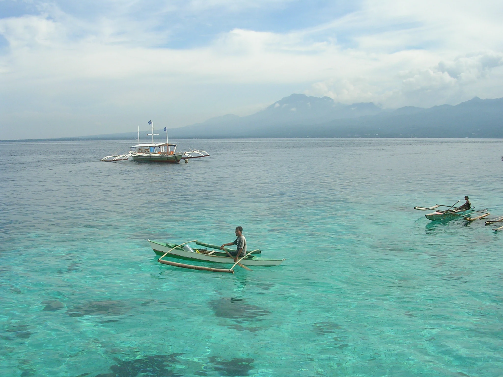
A person rowing a small wooden outrigger canoe in clear shallow turquoise water, with a larger boat and distant mountains visible across the strait.
A person rowing a traditional outrigger boat in the turquoise waters of the Tañon Strait.

Tañon Strait Protected Seascape ecosystems, habitats, and plant life

The Tañon Strait Protected Seascape protects a dynamic marine environment shaped by its function as a connector between the Visayan Sea and the Bohol Sea. The movement of water through this long, narrow passage supports productive ecosystems along the coasts of Negros and Cebu, including mangrove forests, seagrass beds, coral reef systems, and offshore pelagic zones. These habitats together underpin a food web rich enough to sustain large marine mammals.

Mangroves along the strait's shores serve as nursery grounds for fish and crustaceans, while seagrass meadows and reef structures in shallower coastal areas provide habitat for a wide range of invertebrates and reef-associated fish. Deeper waters within the strait provide feeding grounds for pelagic species and the larger marine mammals for which the seascape is best known.

The strait's ecological character is closely tied to its role as a transitional and productive marine zone. The interaction of currents, varied depths, and diverse coastal habitats gives the protected area a layered biodiversity, from coastal wetlands to open-water species, making it ecologically significant on both local and national scales.

Tañon Strait Protected Seascape wildlife and species highlights

The strait is internationally and nationally recognized for its cetacean diversity. Eleven species of marine mammals have been documented in the waters of the Tañon Strait, including baleen whales, toothed whales, dolphins, and porpoises. Among the most notable species using the strait are Irrawaddy dolphins, a species of conservation concern, along with other dolphin and whale species that rely on the area for breeding, feeding, and resting.

The concentration of cetacean activity has made the strait a focal point for whale and dolphin watching tourism, particularly from Bais on the Negros Oriental coast. Regular sightings of multiple species in overlapping habitats are a defining feature of the area's wildlife profile.

Beyond marine mammals, the protected waters and surrounding coastal habitats support the broader marine food web on which cetaceans depend. Fish populations, invertebrates in reef and seagrass systems, and the prey species that attract larger predators all contribute to a wildlife environment of considerable ecological value within the central Visayas.

Tañon Strait Protected Seascape conservation status and protection priorities

Designation of the Tañon Strait as a Protected Seascape in 1998 reflected growing recognition of its ecological importance, particularly its role as habitat for marine mammals. As the largest marine protected area in the Philippines, it represents a cornerstone of national efforts to conserve marine biodiversity in the Visayas and to safeguard critical cetacean habitat from threats such as overfishing, habitat degradation, and industrial activity.

International support has reinforced the protected area's conservation role. The UNDP-backed Smart Seas Philippines project, active between 2014 and 2020, included the Tañon Strait among key marine biodiversity seascape sites, working through local partners including Conservation International Philippines to strengthen management and protection.

A defining element of the seascape's conservation history is the 2008 Supreme Court case that sought to halt oil exploration in the protected waters on behalf of the strait's cetaceans. While the petition framed whales, dolphins, and porpoises as 'Filipino mammals' entitled to constitutional protection, it underscored broader concerns about industrial threats in the protected waters. The case elevated the profile of the seascape in Philippine environmental law and contributed to ongoing discussions about the legal status of marine wildlife.

Tañon Strait Protected Seascape cultural meaning and human context

The Tañon Strait holds a meaningful place in the cultural identity of the Visayas, particularly within Cebuano-speaking communities. In local mythology, the strait is associated with stories of the supreme god Kaptan and his winged giant messengers, one of whom was punished for a transgression and transformed into a sacred crocodile imprisoned in the depths of the waters between Cebu and Negros. Local belief holds that whirlpools in the strait reflect the enduring presence of this mythological figure.

On a more contemporary cultural level, the strait shapes the identity of coastal communities whose livelihoods have historically depended on fishing and increasingly on marine wildlife tourism. Cities such as Bais have become closely associated with whale and dolphin watching culture, integrating traditional maritime life with modern conservation-oriented tourism and giving the protected area a living cultural dimension alongside its ecological importance.

Top sights and standout views in Tañon Strait Protected Seascape

The defining qualities of the Tañon Strait Protected Seascape lie in its scale, its cetacean richness, and its role within Philippine conservation history. Covering more than 5,000 square kilometres between Negros and Cebu, it is the Philippines' largest marine protected area and protects waters that serve as vital habitat for at least eleven marine mammal species, including Irrawaddy dolphins and multiple whale and dolphin species.

Its highlights also include the dramatic physical setting of the strait itself, the prominent whale and dolphin watching tourism based in Bais, and the seascape's place in landmark environmental legal debates. Combined with its grounding in Visayan mythology and its integration of coastal community life with active conservation management, the Tañon Strait Protected Seascape stands out as a uniquely multidimensional marine protected area in the Philippines.

Best time to visit Tañon Strait Protected Seascape

The Tañon Strait Protected Seascape can be enjoyed year-round as part of Visayas travel, but marine wildlife viewing is influenced by seasonal sea conditions typical of the central Philippines. Calmer sea conditions generally offer better opportunities for whale and dolphin watching, while clearer weather enhances the experience of the strait's coastal scenery from viewpoints on both Negros and Cebu.

Given the tropical climate of the Visayas, visitors can expect warm temperatures throughout the year, with variations in rainfall and sea conditions shaping the character of a visit. Coastal landscape views, including those from elevated points such as Osmeña Peak on Cebu, are most rewarding in periods of good visibility, while cetacean encounters depend on both marine conditions and the natural patterns of the animals themselves.
Monthly climate preview

Long-term representative measurements of monthly temperature and precipitation rhythms

Tañon Strait Protected Seascape Annual Climate Normals and Weather by Month

Representative coordinate records show sustained thermal ranges and distinct seasonal precipitation shifts across the protected marine corridor. Examining twelve-month climatology profiles provides structured insight into long-term averages without relying on short-term forecasts.
Annual mean27 °C
26 °C29 °C
Jan26°
Feb26°
Mar27°
Apr28°
May29°
Jun28°
Jul27°
Aug27°
Sep27°
Oct27°
Nov27°
Dec26°
Warmest month
May

28.7 °C

Coolest month
January

25.8 °C

Wettest month
October

7.3 mm/day

Driest month
April

2.3 mm/day

Park location guide

Geography guide, regional context, and park location map for Tañon Strait Protected Seascape

Tañon Strait Protected Seascape park geography, regions, and map view in Philippines

Understand where Tañon Strait Protected Seascape sits in Philippines through a broader geographic reading of the surrounding landscape, nearby location context, and its mapped position within the national park landscape.

How Tañon Strait Protected Seascape fits into Philippines

The Philippines, officially the Republic of the Philippines, is an archipelagic nation in Southeast Asia comprising approximately 7,641 islands categorized into three main geographical divisions: Luzon, Visayas, and Mindanao. Located in the western Pacific Ocean, it shares maritime borders with Taiwan, Japan, Palau, Indonesia, Malaysia, Vietnam, and China. Manila serves as the capital city, while Quezon City is the most populated city, both within Metro Manila.

Wider geography shaping Tañon Strait Protected Seascape in Philippines

The Philippines is an archipelagic nation in Southeast Asia, positioned in the western Pacific Ocean. Its islands are bounded by the South China Sea to the west, Philippine Sea to the east, and Celebes Sea to the south. The country shares maritime borders with Taiwan to the north, Japan to the northeast, Palau to the east and southeast, Indonesia to the south, Malaysia to the southwest, Vietnam to the west, and China to the northwest.

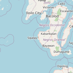
Map view of Tañon Strait Protected Seascape

Use this park location map to pinpoint Tañon Strait Protected Seascape in Philippines, understand its exact geographic position, and read its mapped placement within the surrounding landscape more clearly.

Pigeon | © OpenStreetMap contributors

Location context for Tañon Strait Protected Seascape

Visayas

Visual exploration of coastal geography, marine habitats, and protected waters

Tañon Strait Protected Seascape Photos and Marine Scenery

Visual documentation of Tañon Strait Protected Seascape reveals the expansive marine habitats and varied coastal terrain separating Negros and Cebu. Photographic records provide clear insight into the scale, physical geography, and protected environment of the country's largest marine reserve.

A wide panoramic view of a calm strait at sunset with small outrigger boats floating on the water, reflecting the orange and purple sky.

A high angle panoramic view of jagged, green karst hills in the foreground leading down to a calm, expansive strait of water with a distant island horizon under a cloudy sky.

A person rowing a small wooden outrigger canoe in clear shallow turquoise water, with a larger boat and distant mountains visible across the strait.

Park atlas

Continue exploring connected marine environments and surrounding Visayas geography.

Parks Near Tañon Strait Protected Seascape and Regional Protected Areas

Browsing other protected areas near Tañon Strait Protected Seascape reveals broader marine and coastal geography across the central Visayas. Comparing these neighboring conservation zones provides vital regional context for understanding marine habitats in the Philippines.
National parkCebu
About 32 km away#1 closest

South

Guadalupe Mabugnao Mainit Hot Spring National Park: Protected Landscape and Watershed Geography

Explore hot springs, caves, and mapped terrain in Cebu.

Guadalupe Mabugnao Mainit Hot Spring National Park is a protected national park in Cebu, Philippines, recognized for its significant watershed function and unique natural features. Spanning forested highland terrain within the Mantalongon mountain range, the park protects natural hot springs, explored cave systems such as Cave Lorett, and river networks vital to local water supply. Its identity as a protected landscape offers rich opportunities for geographic exploration, mapping its boundaries, and understanding its role within the regional natural terrain and conservation efforts.

Area
0.575 km²
Established
1972
IUCN
V
Relief
Mountain
A watercolor painting featuring soft green hills in the midground and faint, pale purple mountain silhouettes in the background against a white backdrop.
National parkNegros Occidental
About 43 km away#2 closest

West

Mount Kanlaon Natural Park: Mapping the Volcanic Heart of Negros Island Protected Lands

A comprehensive geographic overview of volcanic terrain and rainforest habitats.

Mount Kanlaon Natural Park protects a defining massif in the Western Visayas, blending active volcanic features with some of the most intact tropical rainforests remaining on Negros Island. This geographic record maps the transition from steep, high-elevation ridges to lower-altitude forest boundaries, providing context on its importance as a refuge for threatened endemic wildlife and a significant center for regional biodiversity conservation.

Area
248.54 km²
Established
1934
Relief
Mountain
Scope
Terrestrial
A watercolor painting showing a panoramic view of a lush wetland landscape with gentle green hills in the distance, a winding stream, and tall grasses and pink wildflowers in the foreground.
Wildlife reserveCentral Visayas
About 59 km away#3 closest

East

Olango Island Wildlife Sanctuary: Coastal Protected Area and Migratory Bird Habitat in Central Visayas

Explore the interconnected mudflats, reefs, and mangrove forest ecosystems

Olango Island Wildlife Sanctuary stands as a key protected landscape in the Central Visayas, defined by its vast tidal flats and critical role in international bird migration patterns. This site features a unique mosaic of salt marshes, seagrass beds, and coral reef systems that support diverse coastal life within the low-lying terrain of the Olango Island Group.

Area
10.3 km²
Established
1992
Relief
Lowland
Climate
Tropical
Wildlife reserveNegros Occidental
About 81 km away#4 closest

Southwest

Ilog-Hilabangan Watershed Forest Reserve: Geography and Protected Forest Boundaries

A vital wildlife reserve and watershed landscape in Negros Occidental

This protected area covers a vast expanse of lowland and montane tropical forest in the heart of Negros Island. By regulating the headwaters of major rivers and maintaining a secure habitat for threatened endemic species, the reserve acts as a fundamental component of the regional geography and biodiversity network in the Western Visayas.

Area
102.11 km²
Established
1990
Relief
Mountain
Scope
Terrestrial
A horizontal watercolor painting showing a soft, hazy landscape with a body of water in the foreground, grassy banks, and rolling hills in the distance.
National parkCentral Visayas
About 96 km away#5 closest

South

Panglao Island Protected Seascape: Geographic Atlas and Marine Park Boundaries

A vital protected marine zone in Central Visayas

The Panglao Island Protected Seascape acts as a key site for studying tropical marine biodiversity and karst-driven coastal geography in the Philippines. Spanning the waters around Panglao Island, this protected area features a mosaic of coral reefs, white sand beaches, and offshore limestone islets that provide essential habitats for thousands of mollusk and crustacean species.

Area
91.12 km²
Established
2018
Relief
Mixed relief
Scope
Mixed
Protected landscapeBohol
About 103 km away#6 closest

Southeast

Rajah Sikatuna Protected Landscape: Mapping the Limestone Forest of Bohol, Philippines

A vital protected area of karst ridges and endemic forest habitats

Rajah Sikatuna Protected Landscape sits as a premier natural landmark in southern Bohol. This area is defined by its extensive karst topography, significant cave systems, and expansive limestone forests. It serves as an essential ecological anchor for the province, offering a unique perspective on the island's diverse upland geography and natural mountain systems.

Area
104.526 km²
Established
1987
IUCN
V
Relief
Mountain
National parkPhilippines
About 119 km away#7 closest

Northwest

Bulabog Putian National Park: Philippines National Park Geographic Context and Mapped Boundaries

Discover the protected landscape identity and regional atlas significance.

Bulabog Putian National Park stands as a designated national park in the Philippines, offering valuable insights for geographic and protected-area exploration. Users can understand its specific location and mapped presence within the country's natural landscape, contributing to a structured atlas of conservation areas. This entry focuses on the park's identity and geographic setting for informed discovery.

Area
8.543 km²
Established
1961
IUCN
V
Relief
Mountain
A soft watercolor painting of a coastal landscape with green rolling hills, distant faint mountains, and light water reflections.
Protected landscapeLeyte
About 124 km away#8 closest

East

Cuatro Islas Protected Landscape/Seascape: Leyte Marine and Island Geography Exploration

Detailed protected area atlas for the Camotes Sea island group

The Cuatro Islas Protected Landscape/Seascape is a notable Philippine conservation zone consisting of four distinct islands including Apid, Mahaba, Digyo, and Himokilan. This geographic profile details the diverse terrain, ranging from uplifted former coral reefs to coral sand islets, while providing a clear understanding of the surrounding marine ecosystem and its role in regional conservation.

Area
125 km²
Established
2000
Scope
Mixed

Common questions about visiting, size, designation, and location context for Tañon Strait Protected Seascape

Tañon Strait Protected Seascape FAQs for park facts, access, geography, and protected area context

Find quick answers about Tañon Strait Protected Seascape, including protected-area facts, park geography, trail and visitor context, and how the park fits into its surrounding country and regional landscape.
MoriAtlas Explorer

Continue Your Protected Areas Search Across the Global Atlas

Deepen your exploration by continuing the structured search for national parks and protected areas worldwide. Utilize the comprehensive filtering capabilities to compare different conservation landscapes and refine your understanding of global park geography. Discover more about the distribution and characteristics of protected natural areas.

Global natural geography