
Mori Atlas logo
Nature reserveTarbeker Moor

Examine the mapped boundaries, glacial basin terrain, and transitional mire restoration of this protected wetland in northern Germany.

Tarbeker Moor Nature Reserve: A Detailed Geographic Atlas of Restored Peatland Landscapes

(FFH-Gebiet Tarbeker Moor)

Tarbeker Moor represents a significant protected nature area within the central glacial meltwater channels of Schleswig-Holstein. The landscape traces its origins to post-glacial peat formation, now serving as a primary example of large-scale bog restoration following decades of industrial extraction. By analyzing the mosaic of open water surfaces, peat-moss mats, and sedge communities, one can visualize the ongoing transition of this site back into a functional mire ecosystem.

wetlandraised bogtransitional mirepeatland restorationnature reserveNatura 2000
A stylized digital illustration of a landscape featuring tall rocky cliffs, a waterfall, a central lake, and a surrounding forest, rendered in a muted, warm-toned color palette.

Tarbeker Moor

Nature reserve

Park overview

Structured park overview, official facts, and landscape profile for Tarbeker Moor

Tarbeker Moor park facts, protected area profile, and essential visitor context

Review the core facts for Tarbeker Moor, including designation, size, terrain, visitor scale, habitats, and operating context in one park-focused overview.

About Tarbeker Moor

Tarbeker Moor occupies a quiet corner of the Schleswig-Holstein countryside, north of the spa town of Bad Segeberg. Despite its modest size, the site carries an outsized ecological significance: it is one of the few surviving fragments of a once-extensive post-glacial peatland that formed within a glacial meltwater channel during the melting of the last ice sheets. Across the surrounding region, comparable bogs were lost to drainage and agricultural conversion in the nineteenth and twentieth centuries. Tarbeker Moor survived, though at heavy cost, when it was the target of industrial peat extraction between 1951 and 1990. The modern character of the area is the product of deliberate recovery work that began in 1991. Rather than being abandoned after mining ended, the former extraction fields were rewetted by damming the small Tensfelder Au watercourse and relying on inflowing spring water from surrounding slopes. Within a relatively short period, this rewetting has transformed the site into a richly patterned wetland. Today the moor is characterized by a small-scale mosaic of habitats. In its western basins, open water alternates with floating rafts of Sphagnum mosses and water arum (Calla palustris), along with stands of the common bladderwort (Utricularia vulgaris). To the east, large areas are dominated by tufted sedge (Carex paniculata), cyperus sedge (Carex pseudocyperus), and soft rush (Juncus effusus), interspersed with grey willow scrub. Rain-fed hollows hold communities of white beak-sedge (Rhynchospora alba) and hare's-tail cottongrass (Eriophorum vaginatum), echoing the structure of classic bog lawn vegetation. The site's mosaic quality and its restored hydrology have allowed a broad return of moisture-dependent wildlife. Amphibians, in particular, thrive in the mix of open water, floating mats, and saturated peat. The Tensfelder Au corridor that passes through the area also supports the Eurasian otter, lending the protected area additional landscape-scale value as a movement and dispersal route.

Quick facts and research context for Tarbeker Moor

Tarbeker Moor is a Natura 2000 habitat protection area (FFH-Gebiet) covering approximately 131 hectares in the rolling moraine landscape of Schleswig-Holstein. It lies near the town of Bad Segeberg and is administered by the state's agricultural, environmental, and rural offices. Designated as a protected site in 2004, the area is treated as a regional conservation priority because of its size, its regenerating bog communities, and its role as a refuge for moisture-dependent wildlife.

Protection and recognition

Documented conservation records and international designations for Tarbeker Moor

Tarbeker Moor Protection Status and Natura 2000 Recognition Data

Tarbeker Moor protection status details bring together documented international recognition sources and official Natura 2000 records. Verified registry data maps out the conservation framework supporting this protected area across official databases.
Park context

Deeper park guide and search-rich context for Tarbeker Moor

Tarbeker Moor history, landscape, wildlife, and travel context

Explore Tarbeker Moor through its history, landscape character, ecosystems, wildlife, conservation priorities, cultural context, and seasonal travel timing in a structured park guide built for atlas discovery and search intent.

Why Tarbeker Moor stands out

Tarbeker Moor is best known as a working example of large-scale bog restoration on a formerly industrially exploited peatland. The site illustrates how a degraded raised bog can transition back toward a moisture-rich, peat-forming landscape through rewetting. Its characteristic mosaic of open water, floating mats of bog vegetation, sedge stands, and peat dams gives it strong ecological value, while the presence of amphibians such as the common toad and moor frog, along with the Eurasian otter along the Tensfelder Au stream, makes it a particularly important wetland habitat in the region.
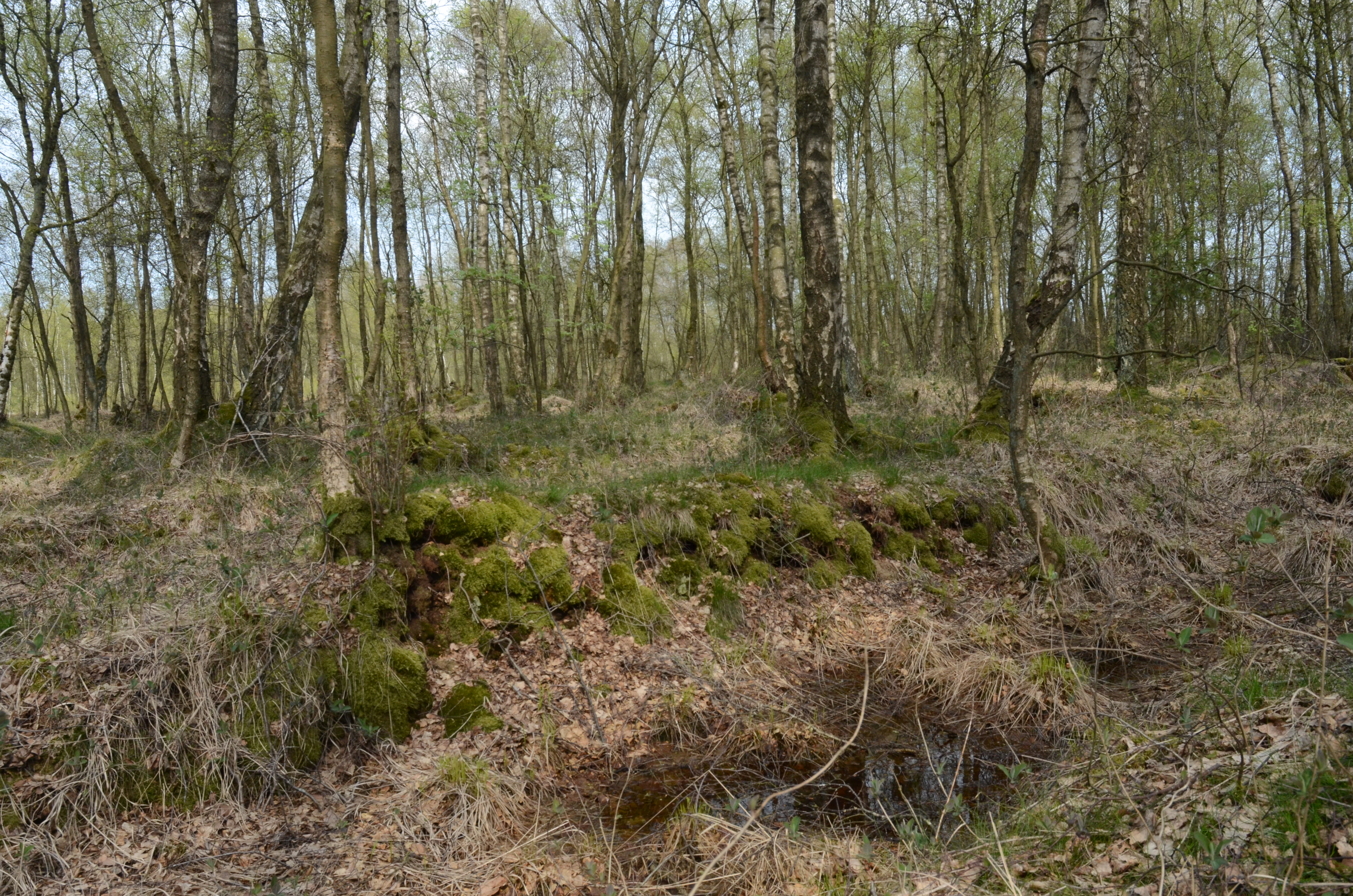
A woodland scene in Tarbeker Moor featuring slender white birch trees with moss-covered ground and dry leaves in the foreground.
A birch bog forest habitat in Tarbeker Moor, showing typical moorland vegetation.

Tarbeker Moor history and protected-area timeline

The boggy surroundings of Tarbeker Moor took shape in the geologically recent aftermath of the last ice age, when peat-forming conditions developed inside a glacial meltwater channel. For thousands of years the wider peatland complex gathered thickness and ecological complexity, but the modern history of the site is largely a story of loss followed by restoration. During the nineteenth and twentieth centuries, the surrounding bogs were drained and progressively converted to grassland and farmland, a pattern common across much of Schleswig-Holstein. Tarbeker Moor was itself exploited as a source of peat from 1951 until 1990, with industrial cutting so intensive that large parts of the bog were removed down to the mineral subsoil. By the end of that period, the original raised bog vegetation had effectively been destroyed. The decisive turning point came in 1991 with the start of a deliberate renaturation program targeting what remained of the still-recoverable bog. The key strategy was rewetting, achieved by damming the Tensfelder Au and allowing groundwater and slope runoff to recharge the substrate. Within a decade this rewetting produced the renewed transitional and floating-mat communities that now define the site. In 2004 the area was formally recognized as an FFH habitat protection area under the European Union Habitats Directive, registered as FFH-Gebiet Nr. 1927-352. Since then, management has focused on optimizing the saturation status of the peat body and on supporting the dispersal of the otter through the connected stream corridor. The site's designation reflects both its ecological recovery and its recognized regional importance as a large-scale, regenerable bog landscape.

Tarbeker Moor landscape and geographic character

Tarbeker Moor sits within the gently undulating terrain of central Schleswig-Holstein, north of Bad Segeberg. The defining landform is the broad, shallow trough of an ancient glacial meltwater channel, in which peat accumulated over thousands of years after the retreat of the Pleistocene ice sheets. Today that trough reads as a quiet, low-lying basin bordered by slightly higher agricultural land. The surface of the protected area is a small-scale patchwork rather than a uniform expanse. Open, still water surfaces dominate the western section, broken by low ridges and dams of residual peat that were partly shaped by former extraction activity. To the east, the terrain carries denser stands of sedge and willow scrub that grew up on the drained but subsequently rewetted cutover fields. Across the site, peat dams and shallow depressions create a subtly varied topography that strongly influences the distribution of vegetation and water.

Tarbeker Moor ecosystems, habitats, and plant life

Ecologically, Tarbeker Moor is a textbook example of a regenerating transitional mire with strong raised-bog affinities. The rewetting of the former peat fields has allowed several distinct vegetation zones to redevelop in close proximity, producing a tight mosaic of ecological conditions on a relatively small footprint. Floating mats formed by peat mosses, water arum, and bladderwort occupy the deeper, permanently flooded western basins. Extending outward from these mats are communities of tufted sedge and cyperus sedge, with grey willow increasingly present in the eastern parts of the site. Soft rush stands fringe the wetter zones and colonize transitional areas. In the rain-fed hollows, classic bog vegetation has returned, with white beak-sedge forming characteristic tussocks alongside hare's-tail cottongrass. Protected habitat types recorded for the site include renaturable degraded raised bogs, transitional and floating-mat mires, and bog hollows with beak-sedge communities. The presence of relatively rare peat mosses such as Sphagnum subnitens and Sphagnum riparium, together with reed, bulrush, and water soldier, indicates that the site is attaining genuine bog-like character rather than merely reverting to generic wetland vegetation.

Tarbeker Moor wildlife and species highlights

Tarbeker Moor's wildlife value lies primarily in its moisture-dependent fauna, which has rebounded strongly alongside the restored hydrology. The area is particularly significant for amphibians, with species such as the common toad and the moor frog finding breeding habitat in the combination of open water, floating vegetation mats, and saturated terrestrial margins that the site now offers. Mammal interest is concentrated along the Tensfelder Au watercourse, which crosses the protected area and supports the Eurasian otter. The otter's continued presence, and the corridor function of the stream, are explicit conservation targets for the site management. Beyond these focal species, the mix of open water, sedge, willow scrub, and adjacent agricultural land creates habitat conditions for a wide range of generalist wetland-associated fauna, from aquatic invertebrates to typical moorland bird communities.

Tarbeker Moor conservation status and protection priorities

Tarbeker Moor carries formal European conservation recognition as a Natura 2000 habitat protection area, designated under the EU Habitats Directive. Its designation rests on three broad strengths: the diversity of bog-related species and habitats present, the visible success of its restoration trajectory, and its size relative to other comparable sites in the region. Together these factors give it a status of statewide significance within Schleswig-Holstein. The overarching conservation goal at the site is to push the vegetation further along the gradient from transitional mire back toward a fully developed raised bog. Achieving this depends on sustained optimization of the watertable across the peat body, which is the single most important management lever available. Equally important is preserving the suitability of the Tensfelder Au corridor as a movement route for the otter, an objective that connects local wetland management with broader landscape-scale mammal conservation.

Top sights and standout views in Tarbeker Moor

Tarbeker Moor stands out for the speed and clarity of its ecological recovery following decades of industrial peat extraction. The site demonstrates how a former cutover bog, once stripped to mineral soil, can be rehydrated and allowed to reassemble transitional and floating-mat vegetation. Its tightly patterned mosaic of open water, sedge, willow, peat-moss mats, and bog-hollow specialists gives the area an unusually high habitat density for its size, and its role as an otter corridor adds a landscape-level dimension to its conservation value.

Best time to visit Tarbeker Moor

The bog character of Tarbeker Moor is most expressive from late spring through early autumn, when warmer conditions bring active growth to the sedge, rush, and moss communities and when open-water surfaces and amphibian activity are easiest to observe. Late spring and early summer are particularly rewarding for visitors interested in bog vegetation, as cottongrass, beak-sedge, and flowering water plants reach their peak visibility. Early morning and evening visits in warmer months also offer the best chances for wetland-associated bird life. In winter, the muted tones of the dormant vegetation and the quiet, flooded basins give the site a more austere but still atmospheric character, with frost often accentuating the structure of the peat dams and sedge stands.

Monthly climate preview

Long term representative measurements tracking twelve month weather patterns

Tarbeker Moor Climate Normals, Average Temperature and Precipitation Rhythm

Tarbeker Moor exhibits a measured annual climate cycle spanning low winter minimums and warm summer maximums alongside consistent daily precipitation records. Examining the complete monthly profile provides detailed historical temperature ranges and precipitation averages across the entire coordinate dataset.
Annual mean9 °C
1 °C18 °C
Jan
Feb
Mar
Apr
May12°
Jun15°
Jul18°
Aug17°
Sep14°
Oct
Nov
Dec
Warmest month
July

17.7 °C

Coolest month
January

0.6 °C

Wettest month
July

2.5 mm/day

Driest month
April

1.4 mm/day

Park location guide

Geography guide, regional context, and park location map for Tarbeker Moor

Tarbeker Moor park geography, regions, and map view in Germany

Understand where Tarbeker Moor sits in Germany through a broader geographic reading of the surrounding landscape, nearby location context, and its mapped position within the national park landscape.

How Tarbeker Moor fits into Germany

Germany is a federal republic in Western and Central Europe with a population of over 83 million across sixteen constituent states. It is Europe's largest economy by nominal GDP and a major global exporter and importer. The capital is Berlin, and the country borders Denmark, Poland, Czech Republic, Austria, Switzerland, France, Luxembourg, Belgium, and the Netherlands.

Wider geography shaping Tarbeker Moor in Germany

Germany is located in Western and Central Europe, spanning 357,022 km². It borders Denmark to the north, Poland and the Czech Republic to the east, Austria and Switzerland to the south, and France, Luxembourg, Belgium, and the Netherlands to the west. The country has coastlines on the Baltic Sea and North Sea to the north, with the Alps located in the southern region.

Map view of Tarbeker Moor

Use this park location map to pinpoint Tarbeker Moor in Germany, understand its exact geographic position, and read its mapped placement within the surrounding landscape more clearly.

Pigeon | © OpenStreetMap contributors

Location context for Tarbeker Moor

Schleswig-Holstein

Explore Tarbeker Moor photos showcasing transitional mires, open water, and bog habitats.

Tarbeker Moor Landscape and Scenery: Visualizing the Protected Wetland

Visual documentation of Tarbeker Moor reveals the intricate mosaic of open water, peat mosses, and sedge communities shaped by active wetland restoration. Examining these protected area views provides a clear understanding of glacial meltwater topography and ecological recovery across the northern German landscape.

A woodland scene in Tarbeker Moor featuring slender white birch trees with moss-covered ground and dry leaves in the foreground.

A wide view of a peat bog landscape with dark, exposed soil in the foreground, sparse vegetation, and a water body in the midground under an overcast sky.

Park atlas

Discover adjacent nature reserves, glacial meltwater channels, and regional wetland habitats

Explore Protected Areas and Parks Near Tarbeker Moor in Schleswig Holstein

Browse nearby protected areas and related wetland habitats situated across the surrounding regional landscape. Comparing neighboring peatlands and nature reserves provides deeper geographic context into northern German ecosystem restoration projects.
Natural monumentSchleswig-Holstein
About 9.1 km away#1 closest

South

Kalkberghöhle Natural Monument: Geological Profile and Protected Karst Landscape in Schleswig-Holstein

Mapping a unique gypsum cave and biological refuge

Located in Bad Segeberg, Kalkberghöhle represents a significant karst formation emerging from the young moraine landscape of northern Germany. The site showcases a rare phreatic gypsum cavern morphology and serves as one of the most vital subterranean bat hibernation habitats in Europe. This protected natural monument offers a distinct look into the interaction between salt tectonics and glacial surface geology.

Established
1913
Visitors
42.2K annual
Relief
Upland
Climate
Temperate
Protected landscapeSchleswig-Holstein
About 17 km away#2 closest

Northeast

Naturpark Holsteinische Schweiz: Geographic Atlas of a Northern German Protected Landscape

Lake-dense glacial regions and forest habitats in Schleswig-Holstein.

Spanning 75,000 hectares across the districts of Ostholstein, Plön, and Segeberg, Naturpark Holsteinische Schweiz offers a rich look at a classic post-glacial landscape. This structured overview details the park's intricate network of lakes, winding streams like the Schwentine, and restored peatlands that support essential waterbird habitats. Gain a deeper understanding of the park's topography, from the Bungsberg ridges to the expansive lowland depressions that define this region.

Area
753.28 km²
Established
1986
Relief
Upland
Climate
Temperate
Watercolor painting of a wide landscape with green fields, rolling hills, and trees with pink and green foliage.
Protected areaSchleswig-Holstein
About 17 km away#3 closest

South

Leezener Au Protected Area: Glacial Tunnel Valley Geography and Habitat Conservation in Schleswig-Holstein

A mapped overview of glacial river corridors and riparian restoration

Discover the geographic essence of the Leezener Au, a protected river corridor shaped by Ice Age glacial activity in Schleswig-Holstein. This area preserves a mosaic of lowland peat, wet meadows, and forested slopes that serve as a crucial habitat link in the regional Trave river basin.

Established
2005
Relief
Lowland
Climate
Temperate
Scope
Terrestrial
Nature reserveSchleswig-Holstein
26 km away#4 closest

Northwest

Wald nordwestlich Boksee Nature Reserve: Geographic Atlas and Protected Landscape Mapping

Ancient deciduous woodland within the Schleswig-Holstein moraine region

Wald nordwestlich Boksee stands as a protected nature reserve representative of Central European beech and oak ecosystems. Situated in the Plön district of Schleswig-Holstein, the site offers a detailed look at glacial moraine landscapes, historic boundary embankments, and the ecological management of ancient woodland habitats. This overview provides mapping context and structural insights into the forest's role within the local biodiversity corridor.

Area
0.25 km²
Established
2004
Relief
Upland
Climate
Temperate
A horizontal watercolor painting depicting a soft, ethereal landscape with green trees on the left and right, a winding stream in the center, and pale rolling hills in the background against a light, misty sky.
Nature reserveSchleswig-Holstein
About 31 km away#5 closest

Northwest

FFH-Gebiet Wennebeker Moor und Langwedel Nature Reserve: Geographic and Landscape Atlas

Protected mire and heathland complex in Schleswig-Holstein

The FFH-Gebiet Wennebeker Moor und Langwedel nature reserve encompasses a complex mosaic of wet and dry heath, quaking bogs, and Nardus grasslands. This site is distinguished by its unique integration of conservation obligations with active military land use, creating a rare habitat environment within a gently rolling morainal landscape.

Area
2.3 km²
Established
2004
Relief
Lowland
Climate
Temperate
A watercolor painting showing a soft, panoramic landscape with rolling hills in the background, a small stream winding through a grassy foreground, and a cluster of trees on the right.
Nature reserveSchleswig-Holstein
About 32 km away#6 closest

Southeast

Kannenbruch Nature Reserve in Schleswig-Holstein: A Regional Atlas of Protected Woodland Geography

Mapping the radial forestry lanes and bog-forest ecosystems

Kannenbruch represents a distinctive intersection of cultural history and natural succession within Schleswig-Holstein. The reserve protects a waterlogged, low-lying bog-forest characterized by its deliberate, star-shaped layout of radiating forestry lanes. This structured landscape provides a window into Biedermeier-era spatial planning while supporting a rich diversity of spring-flowering geophytes on its damp, heavy soils.

Area
0.25 km²
Established
1995
Relief
Lowland
Climate
Temperate
Nature reserveSchleswig-Holstein
36 km away#7 closest

West

Wälder der nördlichen Itzehoer Geest: Protected Area and Forest Landscape Atlas

Natura 2000 ancient woodland in Schleswig-Holstein

Explore the geography of Wälder der nördlichen Itzehoer Geest, featuring four historical forest tracts across glacial moraines. This protected area highlights Atlantic acid beech forests and floodplain habitats, preserving centuries-old woodland continuity within the broader Schleswig-Holstein landscape.

Area
7.11 km²
Established
2004
Relief
Upland
Climate
Temperate
A watercolor painting showing a soft panoramic view of green hills and a winding stream, with distant pale mountains in the background.
Nature reserveSchleswig-Holstein
About 43 km away#8 closest

Northwest

FFH-Gebiet Wehrau und Mühlenau Nature Reserve and River Corridor Geography

Protected riparian habitat in Schleswig-Holstein

Spanning over 246 hectares, this nature reserve protects a vital sequence of lowland streams, including the Mühlenau and Wehrau rivers. The area serves as an important refuge for rare mollusk species and aquatic wildlife, while preserving the integrity of a glacial tunnel valley geotope. This structured map view highlights the connectivity of wetlands, forests, and stream habitats that define the local landscape.

Area
2.46 km²
Established
2004
Relief
Lowland
Climate
Temperate

Common questions about visiting, size, designation, and location context for Tarbeker Moor

Tarbeker Moor FAQs for park facts, access, geography, and protected area context

Find quick answers about Tarbeker Moor, including protected-area facts, park geography, trail and visitor context, and how the park fits into its surrounding country and regional landscape.
MoriAtlas Explorer

Continue Your Protected Areas Search Across the Global Atlas

Deepen your exploration by continuing the structured search for national parks and protected areas worldwide. Utilize the comprehensive filtering capabilities to compare different conservation landscapes and refine your understanding of global park geography. Discover more about the distribution and characteristics of protected natural areas.

Global natural geography