
Mori Atlas logo
Protected landscapeTeinachtal mit Seitentälern

Mapping the river valley corridors, meandering streams, and riparian woodland habitats of the Schwarzwald region.

Teinachtal mit Seitentälern: A Comprehensive Protected Landscape in the Northern Black Forest

(Landschaftsschutzgebiet 'Teinachtal mit Seitentälern')

Teinachtal mit Seitentälern encompasses a vital protected landscape situated in the northern Black Forest of Baden-Württemberg. This expansive valley system extends from the uplands near Neuweiler to the confluence with the Nagold river, safeguarding a complex mosaic of wet meadows, near-natural hillside forests, and meandering tributary brooks that define the regional ecology.

landscape protection areaBlack ForestSchwarzwaldnorthern Black Forestriver valleyTeinach river
A graphic illustration of a deep canyon valley with a vertical waterfall flowing into a river, surrounded by evergreen trees under a sunlit sky.

Teinachtal mit Seitentälern

Protected landscape

Park overview

Structured park overview, official facts, and landscape profile for Teinachtal mit Seitentälern

Teinachtal mit Seitentälern park facts, protected area profile, and essential visitor context

Review the core facts for Teinachtal mit Seitentälern, including designation, size, terrain, visitor scale, habitats, and operating context in one park-focused overview.

About Teinachtal mit Seitentälern

Teinachtal mit Seitentälern is a medium-sized landscape protection area in the northern Black Forest, defined around the drainage basin of the Teinach river and its tributaries. Rather than focusing on a single striking landmark, the area's significance lies in the continuity and ecological coherence of an entire valley system. The protected area runs from Neuweiler downstream to where the Teinach flows into the Nagold, encompassing not only the main valley floor but also the smaller side valleys that feed into it, the valley slopes rising on either side, and adjacent sections of the surrounding plateau.

In administrative terms, the landscape protection area spans the municipalities of Neubulach, Neuweiler, and Bad Teinach-Zavelstein, all of which lie in the Landkreis Calw in Baden-Württemberg. The area sits within the natural region known as the Schwarzwald-Randplatten, the western edge zone of the Black Forest where the forested uplands meet the gentler landscapes to the west. Administratively, it is part of the Naturpark Schwarzwald Mitte/Nord, a large-scale regional park designation that frames the valley within broader Black Forest tourism, recreation, and conservation planning.

Ecologically, the protection area is shaped by the interplay of water, slope, and forest. The Teinach and its tributary streams follow partly natural, sometimes meandering courses, with associated wet meadows, tall herb vegetation, and riparian shrub and woodland strips running along them. The valley slopes carry near-natural hillside forests with a range of habitat structures, while small parts of the area overlap with the FFH site Kleinenztal und Schwarzwaldrandplatten, tying local valley conservation into the wider Natura 2000 network. Together, these elements give the protected area its character as a richly structured Black Forest valley landscape, valued for both its ecological function and its role as a regional recreation and landscape-connection area.

Quick facts and research context for Teinachtal mit Seitentälern

Teinachtal mit Seitentälern is classified as an IUCN Category V Protected Landscape/Seascape and carries the German Schutzgebietsnummer 2.35.053. It was established in its current form on 28 April 2000 by ordinance of the Landratsamt Calw, replacing earlier 1953 and 1954 landscape protection orders for the Teinach valley and the Burgruine Zavelstein area.

The protected area is administered by the Landratsamt Calw and lies within the Naturpark Schwarzwald Mitte/Nord. It overlaps partially with the FFH (Habitat Directive) site 'Kleinenztal und Schwarzwaldrandplatten' (site number 7117-341), linking its valley conservation goals to the wider European Natura 2000 network.

Protection and recognition

Review documented conservation management and official international designations.

Teinachtal mit Seitentälern Protection Status and Recognition Data

Teinachtal mit Seitentälern brings together verified protection status records, designation history, and administrative scope in one structured overview. Official international recognition metrics and database identifiers outline the conservation context for this protected natural area.

Protection details

WDPA ID
325130
Park context

Deeper park guide and search-rich context for Teinachtal mit Seitentälern

Teinachtal mit Seitentälern history, landscape, wildlife, and travel context

Explore Teinachtal mit Seitentälern through its history, landscape character, ecosystems, wildlife, conservation priorities, cultural context, and seasonal travel timing in a structured park guide built for atlas discovery and search intent.

Why Teinachtal mit Seitentälern stands out

The protected area is best known for preserving the Teinach river valley and its wooded side valleys as a continuous, near-natural landscape along the edge of the northern Black Forest. It safeguards meandering stream courses, wet meadows, alluvial structures, and hillside forests that together form one of the more richly structured valley landscapes in the Landkreis Calw. It is also notable as a landscape-level conservation connector, linking traditional valley land use with the broader Naturpark Schwarzwald Mitte/Nord and Natura 2000 habitats, and providing both ecological corridors and recreational space in a densely settled part of the northern Schwarzwald.
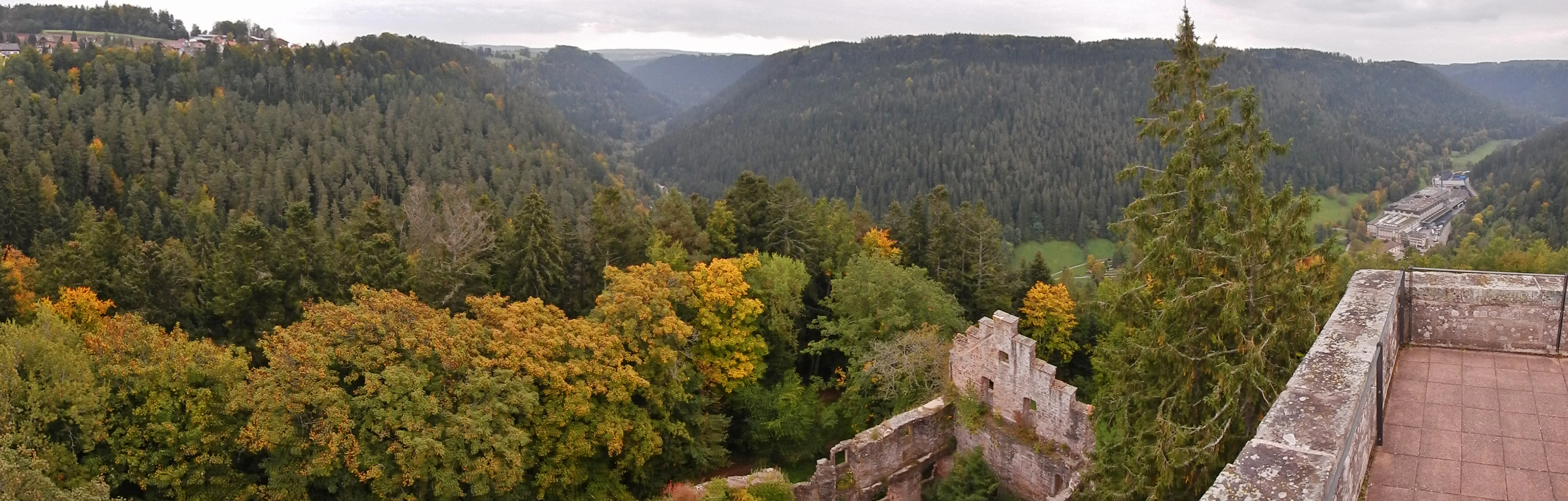
A wide panoramic view from a stone castle wall looking out over a forested river valley during autumn.
Panoramic view over the Teinach valley from the ruins of Zavelstein Castle.

Teinachtal mit Seitentälern history and protected-area timeline

The present-day landscape protection area was created on 28 April 2000 by an ordinance of the Landratsamt Calw. With the entry into force of this ordinance, two earlier protective designations ceased to apply: the 1954 landscape protection ordinance for the Teinach valley and its tributaries the Lauterbach and Dürrbach, originally issued on 20 May 1954, and the 1953 ordinance protecting the Burgruine Zavelstein area, issued on 4 September 1953.

The 2000 consolidation brought the main Teinach valley and its side valleys under a single modern protection framework, reflecting later German conservation practice of combining previously fragmented landscape protection orders into coherent valley-scale units. The reform also aligned the area's designation with the broader Naturpark Schwarzwald Mitte/Nord and with the European Natura 2000 framework through partial overlap with the FFH site Kleinenztal und Schwarzwaldrandplatten.

Teinachtal mit Seitentälern landscape and geographic character

The protected area is fundamentally a valley landscape, defined by the Teinach river corridor and the smaller tributary valleys that open into it. The Teinach flows from the wooded uplands near Neuweiler through a relatively narrow, forested valley before reaching the Nagold river. The valley floor alternates between broader open sections and tighter wooded reaches, with slopes rising on either side toward the surrounding plateau surfaces of the Schwarzwald-Randplatten.

Alongside the river, small tributary brooks such as the Lauterbach and Dürrbach shape narrower side valleys with their own slopes and small floodplain pockets. Where the terrain allows, the valley floor carries wet meadows, tall herb fringes, and riparian woodland strips, while the slopes are cloaked in mixed hillside forest. The combination of meandering watercourses, wet meadows, and near-natural slope woodland gives the valley its clearly layered, often picturesque character, and provides the scenic backdrop seen from vantage points such as the Burgruine Zavelstein high above the valley.

Teinachtal mit Seitentälern ecosystems, habitats, and plant life

Ecologically, the protected area is best understood as a Black Forest valley ecosystem at the transition from forest to valley floor. The Teinach and its tributaries maintain largely natural or near-natural watercourses, and in places meander gently through the valley. These streams are flanked by a narrow but ecologically important mosaic of wet meadows, tall herb communities, and riparian shrub and woodland strips that depend on the river's fluctuating water levels.

The valley slopes sustain hillside forests with varied age structure and habitat elements such as fallen deadwood, rock outcrops, and small clearings. On the plateau edges and upper slopes, forests gradually give way to more open countryside and traditional grassland. Although the protected area is modest in size, its combination of water, meadow, forest, and slope habitats, along with its partial overlap with the Natura 2000 site Kleinenztal und Schwarzwaldrandplatten, gives it an ecological importance that extends well beyond its administrative boundaries.

Teinachtal mit Seitentälern wildlife and species highlights

The wildlife significance of the protected area is closely tied to its structure as a connected valley-and-slope landscape. The intact stream corridors, wet meadows, and riparian woodland provide habitats for stream-dependent invertebrates, amphibians, and fish, while the wet meadows and tall herb fringes support small mammals, ground-nesting birds, and a rich insect fauna. The hillside forests, with their varied structure, offer habitat for typical Black Forest forest species, including woodland birds and mammals that depend on near-natural, structurally diverse woodland.

Because the area is also part of an ecological network linking the Teinach valley to the broader Schwarzwald-Randplatten, including the overlapping FFH site Kleinenztal und Schwarzwaldrandplatten, it functions as a habitat corridor rather than an isolated patch. This connectivity is particularly important for species that move along valley systems rather than across open plateau, and it underpins much of the protected area's conservation rationale.

Teinachtal mit Seitentälern conservation status and protection priorities

Conservation in Teinachtal mit Seitentälern centers on maintaining the valley as an interconnected, near-natural landscape rather than protecting any single feature in isolation. The official protection purpose explicitly calls for the preservation of the richly structured Teinach valley and its side valleys, of the natural, partly meandering stream courses with their wet meadows and woody strips, of the near-natural hillside forests with their habitat structures, and of habitat for protected animal and plant species. The valley is also recognized as a significant landscape-connection element and a regional recreation area.

Long-term conservation objectives include creating a continuous open valley corridor with extensive grassland management and converting non-site-appropriate conifer plantations in the floodplain into natural floodplain woodlands typical of the region. The area's partial overlap with the Natura 2000 site Kleinenztal und Schwarzwaldrandplatten further integrates valley-level conservation into European habitat protection efforts.

Teinachtal mit Seitentälern cultural meaning and human context

The Teinach valley carries significant cultural-historical associations, most visibly through the Burgruine Zavelstein, whose ruins dominate a rocky spur above the valley near Bad Teinach-Zavelstein and which give their name to one of the earlier, now superseded landscape protection orders. The ruined castle and the surrounding valley landscape are closely linked in local identity, and the broader area forms part of the traditional cultural landscape of the northern Black Forest, shaped by centuries of small-scale agriculture, forestry, and settlement along the Teinach and its tributaries.

Top sights and standout views in Teinachtal mit Seitentälern

The valley-scale scope of the protection itself is a defining feature: rather than safeguarding a single peak or reserve, Teinachtal mit Seitentälern preserves an entire valley system from Neuweiler to the Nagold confluence, including side valleys and upper slopes.

Other key highlights include the near-natural, partly meandering Teinach and its tributaries; the layered mosaic of wet meadows, tall herb fringes, and riparian woodland along the valley floor; the near-natural hillside forests with rich habitat structure; the scenic views and cultural landmark of the Burgruine Zavelstein; and the area's role as a connecting element between the Naturpark Schwarzwald Mitte/Nord and the Natura 2000 site Kleinenztal und Schwarzwaldrandplatten.

Best time to visit Teinachtal mit Seitentälern

The valley is attractive across the warmer months, when the contrast between open valley meadows and the surrounding forest is at its most visible and stream-side vegetation is in leaf. Late spring and early summer tend to bring the freshest greens and the most active wildlife along meadow and stream edges, while early autumn highlights the color shift in the mixed hillside forests.

In winter, the valley takes on a quieter, more subdued character, with snow often settling on the surrounding plateau and slopes; visitors interested primarily in the forested scenery and the views from sites such as the Burgruine Zavelstein may find the cold months especially atmospheric, although some valley-side paths can be slippery or temporarily limited by conditions.

Monthly climate preview

Long-term temperature ranges and precipitation averages across twelve recorded months

Teinachtal mit Seitentälern Climate Normals and Monthly Weather Patterns

Representative point measurements reveal the measured annual rhythm of average temperatures and daily precipitation at Teinachtal mit Seitentälern. Examining the complete monthly climate profile provides deeper context for long-term meteorological normals across the terrain.
Annual mean8 °C
-1 °C18 °C
Jan-1°
Feb
Mar
Apr
May12°
Jun16°
Jul18°
Aug18°
Sep14°
Oct
Nov
Dec
Warmest month
July

18.1 °C

Coolest month
January

-0.9 °C

Wettest month
July

3.1 mm/day

Driest month
April

1.9 mm/day

Park location guide

Geography guide, regional context, and park location map for Teinachtal mit Seitentälern

Teinachtal mit Seitentälern park geography, regions, and map view in Germany

Understand where Teinachtal mit Seitentälern sits in Germany through a broader geographic reading of the surrounding landscape, nearby location context, and its mapped position within the national park landscape.

How Teinachtal mit Seitentälern fits into Germany

Germany is a federal republic in Western and Central Europe with a population of over 83 million across sixteen constituent states. It is Europe's largest economy by nominal GDP and a major global exporter and importer. The capital is Berlin, and the country borders Denmark, Poland, Czech Republic, Austria, Switzerland, France, Luxembourg, Belgium, and the Netherlands.

Wider geography shaping Teinachtal mit Seitentälern in Germany

Germany is located in Western and Central Europe, spanning 357,022 km². It borders Denmark to the north, Poland and the Czech Republic to the east, Austria and Switzerland to the south, and France, Luxembourg, Belgium, and the Netherlands to the west. The country has coastlines on the Baltic Sea and North Sea to the north, with the Alps located in the southern region.

Map view of Teinachtal mit Seitentälern

Use this park location map to pinpoint Teinachtal mit Seitentälern in Germany, understand its exact geographic position, and read its mapped placement within the surrounding landscape more clearly.

Pigeon | © OpenStreetMap contributors

Location context for Teinachtal mit Seitentälern

Baden-Württemberg

Visualizing the river valleys, hillside forests, and protected habitats of the northern Black Forest

Teinachtal mit Seitentälern Landscape Photography and Protected Area Scenery

Photographic collections reveal the complex terrain of meandering river corridors, wet meadows, and mixed hillside forests across the protected valley system. Visual documentation provides essential context for understanding habitat structures and landscape features within the northern Black Forest region.

A wide panoramic view from a stone castle wall looking out over a forested river valley during autumn.

Park atlas

Compare adjacent valley reserves and regional Black Forest conservation areas.

Parks Near Teinachtal mit Seitentälern and Surrounding Protected Landscapes

Browsing protected areas near Teinachtal mit Seitentälern reveals connected river valleys and upland forests across the northern Black Forest. Evaluating adjacent nature reserves provides deeper geographic context for regional terrain and protected landscapes.
A horizontal watercolor painting showing a winding river through a soft green valley with rolling hills in the background.
Protected landscapeBaden-Württemberg
About 8.4 km away#1 closest

South

Nagoldtal Protected Landscape: Geography and River Valley Map of the Calw District

A northern Black Forest river corridor spanning eight municipalities

Analyze the territorial structure of Nagoldtal, a designated protected landscape spanning over four thousand hectares in the Calw district. The valley scenery reflects the intersection of the Schwarzwald-Randplatten and the Obere Gäue, characterized by a mosaic of forested slopes, open river valleys, and historical settlement patterns that define this prominent conservation corridor in southwestern Germany.

Area
43.584 km²
Established
1971
IUCN
V
Relief
Upland
Nature reserveBaden-Württemberg
About 15 km away#2 closest

Northwest

Eyach oberhalb Neuenbürg Nature Reserve: Mapped Geography and Protected Area Context

A diverse habitat mosaic in the northern Black Forest highlands

The Eyach oberhalb Neuenbürg nature reserve protects an intricate valley system that cuts through the northern Black Forest. This site is defined by its rich variety of forest, grassland, and rocky habitats clustered across steep hillsides and plateau surfaces. The data highlights the essential land cover and topographical features that sustain this protected area within the Baden-Württemberg regional landscape, offering a precise look at its ecological configuration and physical boundaries.

Area
3.219 km²
Established
2019
Relief
Mountain
Climate
Temperate
A watercolor painting showing a wide, panoramic view of a soft, rolling landscape with gentle hills, grassy fields, and small forested areas against a pale, warm sky.
Protected landscapeBaden-Württemberg
About 17 km away#3 closest

Northeast

Neuhausen-Biet: A Protected Landscape at the Edge of the Northern Black Forest in Baden-Württemberg

Mapping the geographic transition between Gäu plateaus and the Würm valley

Neuhausen-Biet serves as an essential protected corridor connecting open agricultural plateaus with the rising, wood-cloaked ridges of the Black Forest fringe. This landscape is characterized by its dramatic transition in topography, featuring the Würm river valley and a complex mosaic of orchards, meadows, and forest blocks within the Enzkreis district. Understanding its boundaries provides insight into regional habitat connectivity.

Area
19.268 km²
Established
2004
IUCN
V
Relief
Upland
Protected landscapeBaden-Württemberg
About 17 km away#4 closest

South

Waldachtal mit Seitentälern Protected Landscape and Stream Corridor Map

Regional geography in the northern Black Forest

Waldachtal mit Seitentälern consists of a compact network of four protected valley sections centered on the Waldach river in Baden-Württemberg. The terrain features a mosaic of springs, ponds, and wet meadows, providing critical ecological connectivity between the forested Black Forest plateaus and the adjacent open Gäu uplands.

Area
2.923 km²
Established
1998
IUCN
V
Protected landscapeBaden-Württemberg
About 18 km away#5 closest

Northeast

Heckengäu-Weil der Stadt Protected Landscape: Mapping the Cultural Scenery of Baden-Württemberg

A regional mosaic of orchard meadows and river valleys

Heckengäu-Weil der Stadt defines a complex protected area composed of fourteen distinct sub-sections circling the town of Weil der Stadt. This geography preserves an intact cultural landscape of small-scale fields, hedgerows, and the Würm river floodplain, standing as a critical transition zone between the Gäu plateau and the rising foothills of the Black Forest.

Area
17.7 km²
Established
1986
IUCN
V
Relief
Upland
Protected landscapeBaden-Württemberg
About 23 km away#6 closest

North

Grafenhausener Kirschengau: Protected Landscape and Regional Geography in Baden-Wurttemberg

Orchard meadows and Arnbach stream valley terrain.

Spanning 137 hectares near Birkenfeld, the Grafenhausener Kirschengau preserves a vital cultural and ecological mosaic in the Kraichgau uplands. This protected landscape combines calcareous grasslands, wooded slopes, and riparian gallery forest, offering a detailed glimpse into the region's traditional land-use history and geological heritage.

Area
1.366 km²
Established
1983
IUCN
V
Relief
Upland
Protected landscapeBaden-Württemberg
About 24 km away#7 closest

Northwest

Staatswald südlich Bernbach: Protected Landscape and Forested Ridge Atlas

Regional geography of the northern Black Forest in Baden-Württemberg

Staatswald südlich Bernbach represents a key protected landscape area in the northern Black Forest. Known for its continuous woodland covering peaks like the Tannschachberg and the Pfahlwald, the area also preserves unique wetland biotopes and designated natural monuments. This atlas entry provides a detailed look at the geographic boundaries and ecological context of this protected ridge system within the Calw district.

Area
6.471 km²
Established
1953
IUCN
V
Relief
Mountain
Watercolor depiction of a river flowing through a forested landscape with rolling mountains in the background
National parkBaden-Württemberg
About 24 km away#8 closest

West

Black Forest National Park: Baden-Württemberg National Park Geography and Mapped Protected Areas

Explore the mapped boundaries and landscape context of this protected area.

Black Forest National Park serves as a focal point for understanding protected landscapes in Baden-Württemberg. This detailed view highlights its specific geographic identity, mapped boundaries, and its position within the regional atlas. Examine the natural terrain and conservation context that define this important national park.

Area
100.62 km²
Established
2014
IUCN
II
Relief
Mountain

Common questions about visiting, size, designation, and location context for Teinachtal mit Seitentälern

Teinachtal mit Seitentälern FAQs for park facts, access, geography, and protected area context

Find quick answers about Teinachtal mit Seitentälern, including protected-area facts, park geography, trail and visitor context, and how the park fits into its surrounding country and regional landscape.
MoriAtlas Explorer

Continue Your Protected Areas Search Across the Global Atlas

Deepen your exploration by continuing the structured search for national parks and protected areas worldwide. Utilize the comprehensive filtering capabilities to compare different conservation landscapes and refine your understanding of global park geography. Discover more about the distribution and characteristics of protected natural areas.

Global natural geography