

Mori Atlas logo
Protected areaTenggol Island

Mapping the steep tropical interior, fringing reefs, and marine biodiversity of this east coast sanctuary

Tenggol Island: A Detailed Geographic Atlas of This Protected Marine Landscape in Terengganu

Tenggol Island emerges as a compact, mountainous protected landscape rising 272 meters from the South China Sea off the coast of Terengganu. This geographic profile details the island's steep forested interior, extensive fringing reef systems, and the varied underwater terrain of surrounding shoals and pelagic plateaus. Gain insight into the environmental structure and protected status of this significant marine environment through detailed mapping and regional context.

tropical islandscuba divingsnorkelingcoral reefsea turtleswhale sharks

Tenggol Island

Protected area

Park overview

Structured park overview, official facts, and landscape profile for Tenggol Island

Tenggol Island park facts, protected area profile, and essential visitor context

Review the core facts for Tenggol Island, including designation, size, terrain, visitor scale, habitats, and operating context in one park-focused overview.

About Tenggol Island

Tenggol Island is a compact forested island in the South China Sea, lying off the Terengganu coast in the Dungun district of Peninsular Malaysia. It marks the southern end of a string of islands that begins further north with the Perhentians and Redang, and although it is far less developed than those neighbors it shares their basic ingredients: clear tropical water, fringing reef systems, and a green interior of low mountain forest. The main island is small in area but rises sharply to 272 meters, giving it a steep, jungle-clad profile that falls quickly to the sea.

Administratively, Tenggol is part of the state of Terengganu and falls within the mukim of Kuala Dungun, with mainland connections running primarily to the Kuala Dungun jetty. Access is by fast boat rather than by scheduled ferry from a major tourism hub, which has helped keep visitor pressure low. Ferries and speedboats linking the island with Kuala Dungun form the main link to the mainland road network; overland journeys typically connect through destinations such as Kuala Lumpur or Shah Alam to reach this stretch of coast.

The island's modern character is shaped equally by its natural setting and by its relative isolation. Resorts are fewer and smaller than on Perhentian or Kapas, often taking the form of wooden chalets strung along bays and backed by tropical forest. This has helped Tenggol cultivate a reputation as a quieter, more diver-oriented destination. Its draw is simple but specific: tropical island scenery, healthy reef ecology, and a sense of being at the edge of Malaysia's better-known east-coast island arc rather than at its crowded center.

Quick facts and research context for Tenggol Island

Tenggol Island sits in the South China Sea off the east coast of Terengganu, Malaysia, roughly in the middle of the country's popular east-coast island chain. It is part of the Terengganu Marine Park system context, with the main island covering about 2.62 square kilometers and the full archipelago (including tiny Nyirih and Tokong Burung) totaling about 2.83 square kilometers. Its highest point reaches 272 meters, and the interior is covered in tropical vegetation that descends in places to small beaches and rocky coves.

Protection and recognition

Examine the documented conservation scope and international recognition records.

Tenggol Island Protection Status and Protected Area Recognition Data

Tenggol Island features a mixed protection scope outlining documented conservation measures and management classifications. Review official designations and international recognition records compiled for this protected area.

Protection details

Protection scope
Mixed
Transboundary protection
No
Park context

Deeper park guide and search-rich context for Tenggol Island

Tenggol Island history, landscape, wildlife, and travel context

Explore Tenggol Island through its history, landscape character, ecosystems, wildlife, conservation priorities, cultural context, and seasonal travel timing in a structured park guide built for atlas discovery and search intent.

Why Tenggol Island stands out

Tenggol is best known for its scuba diving and snorkeling, with around 20 named dive sites scattered around the island. The bay area of Teluk Air Tawar is considered one of the best places in the region to encounter sea turtles, while Batu Tokong Laut is recognized for schools of trevally and deeper pelagic plateaus. The island is also noted for shipwrecks lying within recreational dive range and for seasonal sightings of whale sharks between July and September, when these large filter feeders move through surrounding waters feeding on plankton and small shrimp.

Tenggol Island history and protected-area timeline

For most of its recorded history, Tenggol Island appears to have remained largely uninhabited, used at most as a temporary stopover by fishers and travelers moving along the Terengganu coast. This pattern shifted in the late twentieth century when the island acquired a more somber place in local memory: in the aftermath of the Vietnam War, Vietnamese boat people attempting to flee across the South China Sea were stranded on Tenggol, an episode that linked this small Malaysian island to the larger refugee crisis of that period.

Modern development on Tenggol began on a modest scale compared to other Terengganu islands. Where Redang and the Perhentians grew into large resort operations, Tenggol remained a smaller, lower-density destination, with only a few beachside chalets and resorts gradually established around bays such as Teluk Air Tawar. Today the principal accommodation, including the Tenggol Island Resort (formerly known as Tenggol Aqua Resort), anchors the island's small tourism economy, while the surrounding waters have become its main draw for divers and snorkelers.

Tenggol Island landscape and geographic character

Tenggol presents a classic steep tropical island profile. The interior rises sharply from sea level to a high point of 272 meters, cloaked in dense tropical vegetation that gives the island a green, mountainous appearance from offshore. Where the slopes meet the sea, the coastline breaks into small bays, rocky points, and a mix of sandy beaches and reef flats, particularly around Teluk Air Tawar on the west side.

The surrounding waters are just as much a part of the island's landscape as the land. Fringing reefs line much of the coast, feeding into deeper pelagic plateaus and submerged rock formations offshore. Batu Tokong Laut, one of the most recognizable underwater landmarks, is a rock structure that rises from deeper water and attracts large schools of pelagic fish. Submerged ridges and ledges around the island give diving and snorkeling a varied terrain, with sandy channels, coral gardens, and steeper drop-offs all within a short boat ride of one another.

Tenggol Island ecosystems, habitats, and plant life

The island's terrestrial ecology is dominated by tropical evergreen forest, transitioning from coastal vegetation and casuarina-like growth on exposed shores into denser broadleaf cover as the slopes rise toward the interior summit. Because much of the island is steep and undeveloped, its forest cover remains largely intact compared with more heavily visited Terengganu islands, and small numbers of resident and migratory land birds find refuge here.

The marine environment is the richer of the two. Reef systems around Tenggol support soft corals, hard corals, sea fans, nudibranchs, and a tangle of macroalgae and seagrass growing near sandy patches. Schools of reef and pelagic fish move through the waters, and larger visitors such as sea turtles are regular enough that certain bays are locally known as reliable turtle viewing spots. Because the island faces the open South China Sea, the surrounding ecosystem also includes deeper-water species that drift in seasonally, reinforcing its character as a transitional space between near-shore reef and offshore pelagic zone.

Tenggol Island wildlife and species highlights

Marine wildlife is the strongest wildlife signal from Tenggol. Sea turtles are among the most reliably encountered large animals, and Teluk Air Tawar is recognized locally as one of the better spots to see them. Schools of trevally, jacks, and other pelagic fish gather around submerged rock formations like Batu Tokong Laut, while reef-dwelling species such as batfish, clownfish, and the distinctive Napoleon wrasse are common sights on shallow reefs. Nudibranchs and other small invertebrates thrive across coral rubble and soft-coral gardens that ring the island.

Perhaps the most striking wildlife phenomenon associated with Tenggol is the seasonal appearance of whale sharks. Between July and September, these large filter feeders are occasionally seen cruising the waters around the island, feeding on plankton and small shrimp that bloom in the area during that window. This seasonal whale shark presence has become a notable point of interest for divers, even though sightings remain a matter of luck and sea conditions.

The terrestrial fauna is less documented in surface sources, but the island's forested interior suggests the presence of typical small island wildlife common to the Terengganu coast: monitor lizards, fruit bats, macaques on the larger Malaysian islands in the chain, and a range of resident and migratory coastal and forest birds. Because the island is small and comparatively undeveloped, land-based wildlife observation tends to be incidental to a visit dominated by underwater activity.

Tenggol Island conservation status and protection priorities

Although neither source describes Tenggol as a formally gazetted marine park in its own right, the island and its surrounding reefs sit within an area of recognized marine ecological importance off the east coast of Terengganu. The reef systems around Tenggol, including both shallow fringing reefs and deeper offshore structures, are part of the broader coral habitat network that supports commercial fisheries, tourism, and biodiversity along the Terengganu coast.

Conservation-relevant themes linked to Tenggol include the protection of coral gardens and soft coral communities from anchor and diver damage, the preservation of sea turtle habitat around bays like Teluk Air Tawar, and the seasonal importance of the surrounding waters as feeding grounds for large migratory species such as whale sharks. The island's low development footprint relative to neighboring Perhentian and Redang has, in effect, given Tenggol a quieter conservation profile by default, though its reefs remain sensitive to sedimentation, over-tourism, and the broader pressures of bleaching events affecting the South China Sea.

Tenggol Island cultural meaning and human context

Tenggol's cultural footprint is small but distinctive. Long left uninhabited, the island has served mainly as a fishing and seafaring waypoint rather than as a settled community, and there is no large resident population whose traditions are tied to it. Its place in regional memory is instead shaped by a few specific events and by its role within the broader island chain of Terengganu.

The most significant cultural association is with the aftermath of the Vietnam War, when Vietnamese boat people were stranded on the island after attempting to flee across the South China Sea. This episode ties Tenggol into the wider story of Indochinese refugee movement through Southeast Asian waters, even though the island itself was only a temporary, involuntary waystation.

In more recent decades, the island has developed a small resort culture of its own: wooden beach chalets and dive-oriented accommodations that reflect the character of Malaysian island tourism rather than any deep indigenous heritage. The wider cultural frame for Tenggol is thus the broader Terengganu maritime identity, defined by east-coast fishing villages, seasonal monsoon rhythms, and a tourism tradition that links Redang, Perhentian, Kapas, and Tenggol into a single recognizable island-hopping culture along the peninsula's eastern shore.

Top sights and standout views in Tenggol Island

Tenggol's standout qualities come down to a compact set of underwater and scenic strengths. Its roughly 20 dive sites combine shallow reef gardens with deeper pelagic zones, shipwrecks suitable for recreational diving, and distinctive submerged rock formations like Batu Tokong Laut, which is known for large schools of trevally. The bay at Teluk Air Tawar offers some of the most reliable turtle encounters on the Terengganu coast.

On land, the island's appeal is quieter but equally distinctive: a small, steep tropical island topped by 272 meters of forested high ground, ringed by a handful of bays and a single dominant resort area rather than sprawling development. Combined with seasonal whale shark sightings between July and September, this gives Tenggol a profile that is more about focused diving and naturalist scenery than about volume tourism.

Best time to visit Tenggol Island

Tenggol's east-facing position in the South China Sea makes the monsoon the defining factor in when and how the island can be visited. The dry season, broadly from March or April through October, brings calmer seas, clearer water, and open resort operations, and within that window the period from July to September is especially known for the chance of whale shark encounters as well as steady diving conditions.

The northeast monsoon, typically arriving from about November and lasting into March, brings strong winds, rougher seas, heavy rain, and frequent closures of water sports and sometimes entire resorts. Visitors during this period may find limited boat services and reduced activity on the island, regardless of what the calendar suggests. Planning around the dry season, and aligning a trip with specific interests such as whale sharks in late summer, gives the most rewarding experience of the island.
Monthly climate preview

Long-term representative monthly averages for Terengganu protected geography

Tenggol Island Climate Normals, Annual Temperature and Precipitation Rhythm

Tenggol Island exhibits a measured annual temperature and precipitation rhythm based on long-term climate normals from representative coordinates. Reviewing the complete twelve-month profile provides detailed meteorological context for evaluating local environmental conditions.
Annual mean28 °C
26 °C29 °C
Jan26°
Feb26°
Mar27°
Apr28°
May29°
Jun29°
Jul28°
Aug28°
Sep28°
Oct28°
Nov27°
Dec27°
Warmest month
May

28.8 °C

Coolest month
January

26.2 °C

Wettest month
December

18.1 mm/day

Driest month
February

3.6 mm/day

Park location guide

Geography guide, regional context, and park location map for Tenggol Island

Tenggol Island park geography, regions, and map view in Malaysia

Understand where Tenggol Island sits in Malaysia through a broader geographic reading of the surrounding landscape, nearby location context, and its mapped position within the national park landscape.

How Tenggol Island fits into Malaysia

Malaysia is a federal constitutional monarchy located in Southeast Asia. The country consists of 13 states and three federal territories, divided by the South China Sea into Peninsular Malaysia on the Indochinese Peninsula and East Malaysia on the island of Borneo. With a population of over 34 million, it achieved independence from Britain in 1957 and became a modern federation in 1963. The country is recognized for its multicultural population, tropical climate, and significant economic role in the region.

Wider geography shaping Tenggol Island in Malaysia

Malaysia occupies a strategic position in Southeast Asia, split by the South China Sea into two distinct regions. Peninsular Malaysia lies on the Indochinese Peninsula, sharing a land border with Thailand to the north and maritime borders with Singapore, Vietnam, and Indonesia. East Malaysia occupies the northern portion of Borneo, sharing land borders with Brunei and Indonesia, and maritime borders with the Philippines and Vietnam. The country's terrain includes coastal plains, mountain ranges such as the Titiwangsa in the peninsula, and extensive tropical rainforests.

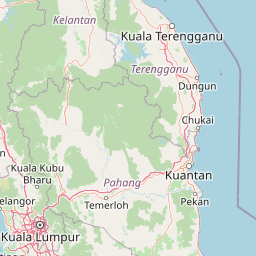
Map view of Tenggol Island

Use this park location map to pinpoint Tenggol Island in Malaysia, understand its exact geographic position, and read its mapped placement within the surrounding landscape more clearly.

Pigeon | © OpenStreetMap contributors

Location context for Tenggol Island

Terengganu
Park atlas

Compare adjacent island archipelagos and coastal marine habitats across Terengganu.

Explore Other Parks Near Tenggol Island and Surrounding Marine Protected Areas

Continue browsing national parks and protected coastal landscapes situated nearby in the South China Sea. Expanding the search route from Tenggol Island reveals wider regional biodiversity and connected island sanctuaries.
Protected areaTerengganu
About 66 km away#1 closest

Northwest

Kapas Island: A Detailed Geographic Overview of the Protected Terengganu Coastal Landscape

Topography, Marine Protection Zones, and Island Geography

Kapas Island offers a focused look at the intersection of coastal geography and conservation management. This small archipelago features a tropical jungle core and protected sandy perimeters, providing a clear map of local reef health and coastal biodiversity in the Terengganu region of Malaysia.

Area
1.5 km²
Relief
Lowland
Climate
Tropical
Access
Easy access
Marine protected areaTerengganu
About 131 km away#2 closest

Northwest

Redang Island Marine Protected Area: Coastal Terrain and Reef Ecosystems

Geographic atlas of the Terengganu island archipelago

Redang Island is a prominent marine protected area within the South China Sea, characterized by its forested interior, sheltered bays like Teluk Dalam, and expansive coral reef systems. As a key ecological site off the Terengganu coast, the island provides a unique study in island geography and marine conservation, offering detailed insights into the protected reef environments and coastal morphology of Peninsular Malaysia.

Area
24.2 km²
Relief
Upland
Climate
Tropical
Access
Moderate access
National parkPahang
About 135 km away#3 closest

West

Taman Negara National Park: Pahang Protected Area with Mapped Boundaries for Geographic Discovery

Explore the unique landscape context within Pahang, Malaysia.

Delve into Taman Negara National Park, a significant protected area situated in Pahang, Malaysia. This detailed view highlights the park's mapped boundaries and its contribution to the regional geography. Understand the protected landscape and its place within the natural terrain of Peninsular Malaysia, essential for atlas-based geographic exploration.

Area
4,343 km²
Established
1938
IUCN
II
Relief
Mixed relief
Marine protected areaTerengganu
About 140 km away#4 closest

Northwest

Lang Tengah Island Marine Protected Area: Geography, Reefs, and Island Terrain

A tranquil protected landscape in the Terengganu archipelago

Lang Tengah Island represents a significant marine protected area defined by its dense forested interior and surrounding coral reef ecosystems. Located within the Terengganu marine region, the island offers a unique study of protected coastal geography, seasonal turtle nesting grounds, and undisturbed tropical marine environments separated from more developed nearby archipelagos.

Area
1.3 km²
Relief
Lowland
Climate
Tropical
Access
Moderate access
State or regional parkTerengganu
About 144 km away#5 closest

Northwest

Setiu Wetlands State Park: Geography and Protected Area Atlas of Terengganu

Coastal lagoons, mangrove forests, and riverine ecosystems

Encompassing the largest natural wetland on Malaysia's east coast, Setiu Wetlands State Park serves as a critical protected landscape where sea, sand, and forest meet. This atlas entry details the park's 23,000 hectare expanse, highlighting the complex hydrological network of lagoons and river basins that support diverse habitats, including peat swamps and seagrass beds.

Area
230 km²
Established
2018
Relief
Lowland
Climate
Tropical
Marine protected areaTerengganu
About 162 km away#6 closest

Northwest

Perhentian Islands Marine Protected Area: Terengganu Coastal and Archipelago Geography

Mapped marine boundaries and tropical island terrain

An immersive look at the Perhentian Islands, a protected nine-island archipelago in the South China Sea. Analyze the distinct marine geography, from fringing coral reefs and shallow reef flats to the forested inland hills of Perhentian Besar and Perhentian Kecil. This overview provides spatial context for one of Malaysia's most recognizable marine environments, emphasizing the protected status of its surrounding waters and reef habitats.

Area
15.955 km²
Established
1994
Relief
Lowland
Climate
Tropical
Biosphere reservePahang
About 173 km away#7 closest

Southwest

Chini Lake Biosphere Reserve: Protected Freshwater Geography in Pahang, Malaysia

Examining the interconnected lake basins and tropical wetland terrain

Chini Lake is an essential protected freshwater system in Pahang, Malaysia, comprising a series of twelve connected lake basins and tropical forest margins. This landscape is a recognized UNESCO Biosphere Reserve, characterized by seasonal lotus blooms, peat-influenced wetlands, and deep cultural connections to the indigenous Jakun communities. Discover the geography and environmental context of this river-fed ecosystem.

Area
50.85 km²
Established
2019
Relief
Lowland
Climate
Tropical
Wildlife reservePahang
About 206 km away#8 closest

Southwest

Tengku Hassanal Wildlife Reserve: Protected Forest and Mountain Geography in Pahang

Mapping a vast lowland dipterocarp forest sanctuary.

Spanning over 600 square kilometers, Tengku Hassanal Wildlife Reserve stands as a core protected area within Pahang. Its landscape includes riverine valleys and the steep montane terrain of the Benom Complex, supporting unique biodiversity and active wildlife conservation. This overview traces the park's geographic footprint and its role as an ecological corridor within the broader Titiwangsa mountain system.

Area
605.52 km²
Established
1923
Relief
Mountain
Climate
Tropical

Common questions about visiting, size, designation, and location context for Tenggol Island

Tenggol Island FAQs for park facts, access, geography, and protected area context

Find quick answers about Tenggol Island, including protected-area facts, park geography, trail and visitor context, and how the park fits into its surrounding country and regional landscape.
MoriAtlas Explorer

Continue Your Protected Areas Search Across the Global Atlas

Deepen your exploration by continuing the structured search for national parks and protected areas worldwide. Utilize the comprehensive filtering capabilities to compare different conservation landscapes and refine your understanding of global park geography. Discover more about the distribution and characteristics of protected natural areas.

Global natural geography