Mori Atlas logo
Protected landscapeTeufenbachtal

Geographic analysis of stream valley boundaries, forest-meadow mosaic, and regional terrain

Teufenbachtal Protected Landscape: Mapping the Geography of a Black Forest Valley in Germany

(Landschaftsschutzgebiet Teufenbachtal)

Teufenbachtal encompasses a protected valley corridor in the Baden-Württemberg region of Germany. This protected landscape extends along the Teufenbach stream, preserving a mosaic of forest slopes, open agricultural meadows, and relic heathland patches. The valley provides a clear geographic unit that serves as an important component of the broader regional ecological network found along the eastern transition zone of the Black Forest.

protected landscapevalleyBlack ForestBaden-Württembergspruce forestpine forest

Teufenbachtal

Protected landscape

Park overview

Structured park overview, official facts, and landscape profile for Teufenbachtal

Teufenbachtal park facts, protected area profile, and essential visitor context

Review the core facts for Teufenbachtal, including designation, size, terrain, visitor scale, habitats, and operating context in one park-focused overview.

About Teufenbachtal

Teufenbachtal is a small protected landscape area (Landschaftsschutzgebiet) in southern Baden-Württemberg, set along the valley carved by the Teufenbach stream on the eastern fringes of the Black Forest. The reserve lies within the municipality of Niedereschach in the Schwarzwald-Baar-Kreis district and extends along the stream corridor between two district boundaries, near Flözlingen to the northwest and near Horgen to the southeast.

The defining character of the area is the contrast between steep, mostly forested slopes and the small patches of open land that line the valley floor. Much of the woodland today consists of spruce and pine plantations that were established on land that once carried extensive juniper heathland, a traditional cultural landscape of the region. Remnants of these species-poor nutrient-low grasslands (Magerrasen) still survive in places, notably around the area known as Brand, providing a glimpse of the valley's pre-forest vegetation pattern.

Alongside the woodland, Teufenbachtal includes open sections managed as meadows and fields, and these open parts are ecologically significant. A particularly notable feature is the presence of the endemic Spelz-Trespe (Bromus grossus) in these habitats, making the valley one of the local strongholds for this species. The artificial Teufensee, situated near the center of the protected area, adds a small but distinctive component to the landscape.

From a conservation perspective, Teufenbachtal is not isolated: the reserve partly overlaps with the much larger FFH (Flora Fauna Habitat) site Baar, Eschach und Südostschwarzwald, which links its habitat values to broader efforts to protect forest and valley ecosystems at the regional scale. On neighboring Horgen territory, the adjacent Teufenbach-Fischbach-Tal protected landscape continues the conservation corridor along the same stream system, reinforcing the role of Teufenbachtal as one link in a chain of valley-focused reserves that characterize the landscape of the Schwarzwald-Baar-Kreis.

Quick facts and research context for Teufenbachtal

Teufenbachtal is a protected landscape area (Landschaftsschutzgebiet) covering about 129 hectares in Niedereschach, in the Schwarzwald-Baar-Kreis of Baden-Württemberg. It lies in the valley of the Teufenbach stream, extending between the district boundary near Flözlingen and the district boundary near Horgen, on the Fischbacher cadastral area.

It was established on 17 February 1989 by regulation of the Landratsamt Schwarzwald-Baar-Kreis and is managed at the district level. The protected landscape forms part of a wider conservation mosaic in the region, overlapping with the FFH site Baar, Eschach und Südostschwarzwald and adjoining the similarly named Teufenbach-Fischbach-Tal protected landscape in the neighboring Horgen area.

Protection and recognition

Terrestrial conservation metrics, management parameters, and international framework records

Teufenbachtal Protection Status and Documented Protected Area Designation

Comprehensive protected area records for Teufenbachtal outline terrestrial conservation parameters, management scopes, and designated status metrics. Official datasets compile verified international recognition sources alongside baseline administrative classifications for analytical evaluation.

Protection details

Protection scope
Terrestrial
Transboundary protection
No
WDPA ID
325148
Park context

Deeper park guide and search-rich context for Teufenbachtal

Teufenbachtal history, landscape, wildlife, and travel context

Explore Teufenbachtal through its history, landscape character, ecosystems, wildlife, conservation priorities, cultural context, and seasonal travel timing in a structured park guide built for atlas discovery and search intent.

Why Teufenbachtal stands out

Teufenbachtal is best known as a small but ecologically diverse protected valley: a wooded stream valley that preserves a patchwork of spruce and pine plantations, relic dry grassland on former juniper heathland (Wacholderheiden), and open meadows with a notable occurrence of the endemic Spelz-Trespe (Bromus grossus). The artificial Teufensee near the center of the area gives the valley a recognizable focal point within an otherwise continuous forested landscape.
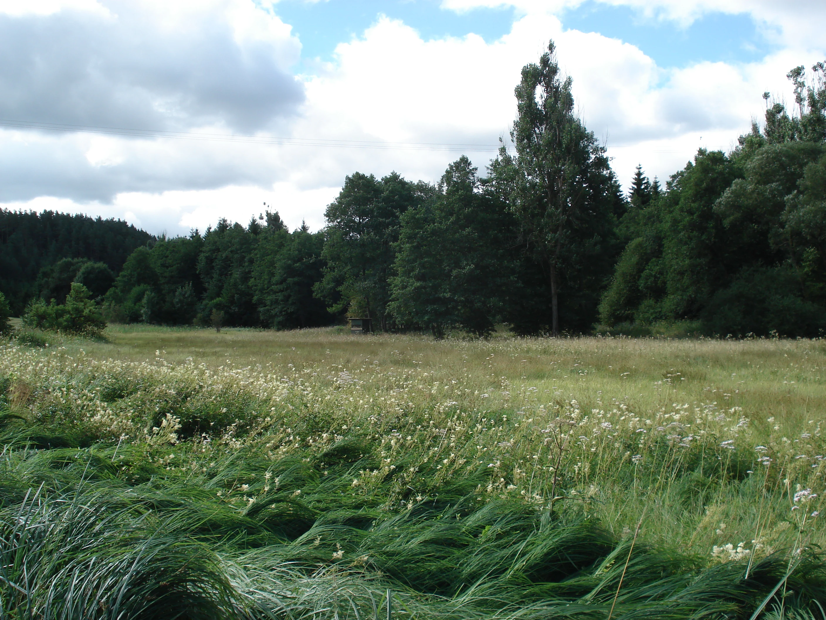
A landscape view of a grassy meadow with wildflowers in the foreground and a dense forest in the background under a cloudy sky.
Grassy meadow with wildflowers bordering a dense mixed forest at the Teufental natural monument.

Teufenbachtal history and protected-area timeline

Teufenbachtal was designated as a protected landscape (Landschaftsschutzgebiet) on 17 February 1989 through a formal regulation issued by the Landratsamt Schwarzwald-Baar-Kreis, the district administration responsible for the area. The designation focused on preserving the valley's mixed character of forested slopes, open meadows, fields, and the associated habitat types along the Teufenbach stream on the territory of Niedereschach.

After its establishment, the area continued to be recognized within broader regional conservation frameworks, including through overlap with the FFH site Baar, Eschach und Südostschwarzwald. The adjoining designation of the Teufenbach-Fischbach-Tal protected landscape on neighboring Horgen cadastral territory extended the conservation corridor further along the same drainage, reflecting an incremental approach to protecting the valley landscape of the eastern Black Forest foothills.

Teufenbachtal landscape and geographic character

The landscape of Teufenbachtal is shaped by the narrow, valley-like corridor of the Teufenbach stream and its flanking slopes. The valley runs between two district boundaries, near Flözlingen and near Horgen, producing a relatively elongated, clearly bounded landscape unit.

The slopes that define the valley are predominantly forested. Spruce and pine plantations dominate the wooded cover, much of it planted on ground that historically supported juniper-rich heathland typical of the Baar and eastern Black Forest region. Where the plantations thin out, scattered relic patches of species-poor dry grassland survive, with one of the more notable examples found at a locality referred to as Brand.

On the valley floor and in clearings, the character shifts to a more open agricultural mosaic. Meadows and fields break up the woodland, creating the structural diversity that gives Teufenbachtal its particular ecological value. Near the middle of the protected area sits the Teufensee, an artificially created waterbody that adds a small but visually distinct element to an otherwise forested and grassy landscape.

Teufenbachtal ecosystems, habitats, and plant life

Teufenbachtal's natural character reflects the interplay between woodland and traditional cultural land use. The forested slopes are dominated by spruce and pine, two species widely used in twentieth-century afforestation in the region, but ecologically the valley still carries traces of much older vegetation patterns. Before the widespread plantings, large parts of these slopes were juniper heathland (Wacholderheiden), a habitat type defined by low, sparse vegetation on nutrient-poor, often shallow soils.

Today, only fragments of that original Magerrasen vegetation remain, preserved in small relict patches scattered across the valley. These open, dry, low-nutrient grassland patches are ecologically precious because they support specialized plant communities that are otherwise rare in the modern landscape. The open meadows and fields maintained by local agriculture are an equally important component, providing a habitat gradient from forest edge to fully open ground that benefits many species.

The valley's most distinctive natural feature is its population of the Spelz-Trespe (Bromus grossus), a grass species with a limited and endemic distribution. Its presence in the open sections of Teufenbachtal places the valley within the network of important sites for this rare species and adds a particular botanical value to the otherwise broadly characterized valley landscape.

Teufenbachtal conservation status and protection priorities

From a conservation perspective, Teufenbachtal is a small but well-connected link in the protection of valley ecosystems at the eastern edge of the Black Forest. Designated in 1989 by the district administration, it preserves a landscape mosaic of forest, dry grassland relicts, and open agricultural land that would otherwise be vulnerable to intensification of forestry or land use.

A key element of its conservation significance is the overlap with the larger FFH (Flora Fauna Habitat) site Baar, Eschach und Südostschwarzwald. This overlap ties the valley's habitat values into a regional network of protected forest and valley ecosystems, strengthening the overall coherence of conservation efforts across the border area between the Black Forest and the Baar.

The protection of the area is also reinforced by the presence of the flächenhaftes Naturdenkmal Teufental within it, a formally registered natural monument that highlights a specific site of ecological interest, and by the adjoining Teufenbach-Fischbach-Tal protected landscape on Horgen territory, which extends the conservation corridor along the same stream system. Together, these layers of designation reflect a layered approach to conservation: landscape-level protection through the Landschaftsschutzgebiet, habitat-level protection through the FFH designation, and site-level protection through the natural monument.

Monthly climate preview

Track representative temperature ranges and monthly precipitation averages across the protected terrain

Teufenbachtal Climate Normals and Long Term Weather Patterns

Long term climate data for Teufenbachtal reveals a measured annual rhythm of recorded monthly temperatures and precipitation rates from representative sampling points. Reviewing the complete twelve month profile provides granular baseline statistics for analyzing regional weather patterns across the protected landscape.
Annual mean8 °C
-2 °C17 °C
Jan-2°
Feb-1°
Mar
Apr
May12°
Jun15°
Jul17°
Aug17°
Sep13°
Oct
Nov
Dec-1°
Warmest month
July

17.2 °C

Coolest month
January

-1.7 °C

Wettest month
June

3.7 mm/day

Driest month
February

1.9 mm/day

Park location guide

Geography guide, regional context, and park location map for Teufenbachtal

Teufenbachtal park geography, regions, and map view in Germany

Understand where Teufenbachtal sits in Germany through a broader geographic reading of the surrounding landscape, nearby location context, and its mapped position within the national park landscape.

How Teufenbachtal fits into Germany

Germany is a federal republic in Western and Central Europe with a population of over 83 million across sixteen constituent states. It is Europe's largest economy by nominal GDP and a major global exporter and importer. The capital is Berlin, and the country borders Denmark, Poland, Czech Republic, Austria, Switzerland, France, Luxembourg, Belgium, and the Netherlands.

Wider geography shaping Teufenbachtal in Germany

Germany is located in Western and Central Europe, spanning 357,022 km². It borders Denmark to the north, Poland and the Czech Republic to the east, Austria and Switzerland to the south, and France, Luxembourg, Belgium, and the Netherlands to the west. The country has coastlines on the Baltic Sea and North Sea to the north, with the Alps located in the southern region.

Map view of Teufenbachtal

Use this park location map to pinpoint Teufenbachtal in Germany, understand its exact geographic position, and read its mapped placement within the surrounding landscape more clearly.

Pigeon | © OpenStreetMap contributors

Location context for Teufenbachtal

Baden-Württemberg

Explore photographic views of forested stream corridors, open meadows, and unique habitats

Teufenbachtal Photos and Landscape Scenery: Visualizing the Protected Valley

Visual documentation of Teufenbachtal reveals the intricate topography of the protected stream valley, including dense spruce plantations and open grassland clearings. Examining these landscape views helps researchers and visitors understand the distinctive terrain and ecological composition of the reserve.

A landscape view of a grassy meadow with wildflowers in the foreground and a dense forest in the background under a cloudy sky.

Park atlas

Compare adjacent forest reserves and valley sanctuaries across the region

Explore Parks Near Teufenbachtal and Surrounding Protected Landscapes

Visitors exploring Teufenbachtal can continue their geographic research by browsing other protected areas and valley landscapes in the vicinity. Examining adjacent reserves reveals broader ecological patterns across the eastern Black Forest and Baar plateau transition zone.
Protected landscapeBaden-Württemberg
About 5.7 km away#1 closest

North

Heckengelände im Gewand Kaltenberg: Protected Landscape and Farmland Mosaic in Baden-Württemberg

Examining traditional hedgerow patterns and regional Muschelkalk geology

Heckengelände im Gewand Kaltenberg offers a window into the Obere Gäue natural region, preserving a unique structural mosaic of agricultural fields and woody hedgerow bands. Established in 1953, this protected landscape demonstrates the historical land management and geological diversity found where the Black Forest meets the Swabian Alb.

Area
0.202 km²
Established
1953
IUCN
V
Relief
Upland
Protected landscapeBaden-Württemberg
About 7.7 km away#2 closest

West

Villingen Süd Protected Landscape: Geographic Atlas and Cultural Heritage Map

Agricultural mosaic within the Baar plateau of Baden-Württemberg

Examine the territorial boundaries and ecological features of Villingen Süd. This protected landscape highlights the integration of historical Iron Age burial sites like Magdalenenberg with traditional agricultural practices, including meadows, hedgerows, and small woodland patches located within the broader Naturpark Südschwarzwald.

Area
4.89 km²
Established
1991
IUCN
V
Relief
Upland
Protected landscapeBaden-Württemberg
About 7.8 km away#3 closest

Southwest

Gaienbühl Protected Landscape: Regional Geography and Map of the Middle Black Forest

Protected mosaic of meadow and forest in Baden-Württemberg

Gaienbühl provides a concentrated example of the Middle Black Forest's rolling terrain, featuring a blend of forest patches and expansive central meadows. The area encompasses critical wetland biotopes and integrates into broader regional bird conservation zones. This record details the protected boundaries and landscape elements that define this specific site within the Schwarzwald-Baar-Kreis district.

Area
0.502 km²
Established
1954
IUCN
V
Protected landscapeBaden-Württemberg
About 8 km away#4 closest

Southeast

Hänge mit Wald und Hecken im Neckartal und Mückenbachtal Protected Landscape and Valley Map

Geographic study of the upper Neckar valley and Mückenbachtal terrain

Investigate the layered landscape of Hänge mit Wald und Hecken im Neckartal und Mückenbachtal, where open grassland plains meet steep, forest-covered valley walls. This protected area provides a clear look at regional river-valley morphology and the integration of natural habitats near the A 81 corridor within the Baden-Württemberg state boundaries.

Area
0.223 km²
Established
1953
IUCN
V
Relief
Upland
Protected landscapeBaden-Württemberg
About 8.5 km away#5 closest

North

Heckengelände zwischen Dunningen und Seedorf: Protected Landscape and Regional Geography

Hedgerow network and agricultural mosaic of Baden-Württemberg

Defined by its dense system of historical field hedgerows, this protected landscape in the Rottweil district maintains a unique ecological mosaic across an undulating plateau. The area features a complex interaction of loess-loam overlays, sedimentary hollows, and open farmland, representing a preserved traditional agricultural landscape within the broader context of Baden-Württemberg.

Area
7.53 km²
Established
1993
IUCN
V
Relief
Upland
Protected landscapeBaden-Württemberg
About 11 km away#6 closest

East

Wacholderheide Dissenhorn: Protected Landscape Mapping and Regional Geography in Baden-Württemberg

A preserved juniper heath mosaic within the Southwestern Alb Foothills

Wacholderheide Dissenhorn represents a vital protected landscape area near Göllsdorf, where the projecting Dissenhorn slope preserves a historic juniper heath mosaic. Defined by Middle Keuper geological formations, this terrain offers a clear look at local habitat management and the transition between open heath and mixed coniferous forest in Germany.

Area
0.101 km²
Established
1953
IUCN
V
Protected landscapeSchwarzwald-Baar-Kreis
About 12 km away#7 closest

Southwest

Groppertal Protected Landscape in Schwarzwald-Baar-Kreis: Regional Geography and Atlas

Mapped riparian meadows and Black Forest woodland boundaries

Groppertal is a protected landscape situated within the Schwarzwald-Baar-Kreis, defined by the Brigach river valley. The area exhibits a unique contrast between maintained lowland wet meadows and expansive forest slopes. This geography provides an essential protected corridor connecting the riparian ecosystem of the river floodplain to the wider highland terrain of the South-eastern Black Forest, illustrating a complex rural-natural mosaic.

Area
5.397 km²
Established
1957
IUCN
V
Relief
Upland
Abstract watercolor illustration of rolling green hills with soft yellow and pink washes and a winding path through a valley
Protected landscapeBaden-Württemberg
About 12 km away#8 closest

Northeast

Neckartal mit Seitentälern von Rottweil bis Aistaig Protected Landscape Map and Regional Context

Protected river valleys and plateau topography in Baden-Württemberg

This protected landscape in Baden-Württemberg features a sequence of twenty dramatic meander loops where the Neckar river cuts 140 meters into the bedrock. The protected area offers a complex geography of steep valley slopes, incised tributary notches, and historic castle-crowned ridges that reveal the evolution of the Obere Gäue terrain.

Area
16.05 km²
Established
1953
IUCN
V

Common questions about visiting, size, designation, and location context for Teufenbachtal

Teufenbachtal FAQs for park facts, access, geography, and protected area context

Find quick answers about Teufenbachtal, including protected-area facts, park geography, trail and visitor context, and how the park fits into its surrounding country and regional landscape.
MoriAtlas Explorer

Continue Your Protected Areas Search Across the Global Atlas

Deepen your exploration by continuing the structured search for national parks and protected areas worldwide. Utilize the comprehensive filtering capabilities to compare different conservation landscapes and refine your understanding of global park geography. Discover more about the distribution and characteristics of protected natural areas.

Global natural geography