

Mori Atlas logo
Wildlife reserveTonda Wildlife Management Area

A vast lowland mosaic of tidal rivers, savanna woodlands, and freshwater swamp ecosystems

Tonda Wildlife Management Area: Mapping the Protected Wetlands of Western Province, Papua New Guinea

Tonda Wildlife Management Area represents the largest protected expanse in Papua New Guinea, anchoring a vital tri-national conservation corridor across the Trans-Fly savanna. This expansive low-relief terrain, sitting mostly below 45 metres in elevation, creates a dynamic wetland landscape of mangroves, open grasslands, and freshwater swamps. The area serves as a critical staging ground for migratory waterbirds within the Australasian flyway, showcasing a unique intersection of customary land governance and international wetland status.

wetlandssavannaTrans-Flymangrovesmigratory birdswaterbirds

Tonda Wildlife Management Area

Wildlife reserve

Park overview

Structured park overview, official facts, and landscape profile for Tonda Wildlife Management Area

Tonda Wildlife Management Area park facts, protected area profile, and essential visitor context

Review the core facts for Tonda Wildlife Management Area, including designation, size, terrain, visitor scale, habitats, and operating context in one park-focused overview.

About Tonda Wildlife Management Area

The Tonda Wildlife Management Area is a vast lowland wetland landscape in the far south-western corner of Papua New Guinea, and it holds the distinction of being the country's largest protected area. It occupies a broad expanse of flat coastal floodplain in Western Province, immediately adjacent to the Indonesian border, where it connects directly with Wasur National Park across an international boundary that is otherwise barely visible on the ground.

The landscape is shaped more by water than by relief. Elevations remain generally below 45 metres above sea level, and the terrain alternates between tidal river reaches, mangrove fringes, freshwater swamps, open grasslands, savanna woodlands and isolated patches of monsoon forest. The savanna elements are dominated by Acacia and Melaleuca trees, while the wetter margins carry extensive stands of Phragmites and Pseudoraphis grasses, giving the area the character of a vast, seasonally flooded plain fringed by estuarine forest.

Ecologically, Tonda sits in the heart of the Trans-Fly savanna and grasslands ecoregion, which extends across the border into Indonesian Papua and historically linked wetlands farther south. The mix of saltwater influence from the south coast and freshwater influx from inland rivers creates a gradient of habitats that supports large numbers of waterbirds, fish, reptiles and mammals, several of which are restricted to this corner of New Guinea.

Beyond its ecological profile, Tonda is also notable for the way it is governed. The land remains under customary ownership, and around 1,500 subsistence gardeners and hunters live in roughly twelve villages scattered across the management area, including communities of the Kanum people in the western part of the reserve. This makes Tonda a working wetland landscape, where traditional land use, wildlife management rules and international conservation recognition operate side by side.

Quick facts and research context for Tonda Wildlife Management Area

Tonda Wildlife Management Area is Papua New Guinea's single largest protected area, covering roughly 5,900 square kilometres of low-lying floodplain in the country's far south-west. Its protected-area status dates to 1975, while its international wetland recognition under the Ramsar Convention was granted in 1993.

The area lies at the south-western edge of Western Province, directly adjoining Indonesia's Wasur National Park, and together they form the core of the Trans-Fly savanna and grasslands ecoregion. More than 250 waterbird species have been recorded here, and the area hosts traditional customary landowners living in a small number of villages across the floodplain.

Protection and recognition

Examine documented protection scope, designation history, and Ramsar wetland recognition details.

Tonda Wildlife Management Area Protection Status and International Recognition Data

Comprehensive protected area records outline the documented designation status and international recognition profile for Tonda Wildlife Management Area. Structured conservation attributes detail official Ramsar wetland listings alongside verified management framework sources.

International recognition

Protection details

Transboundary protection
No
Park context

Deeper park guide and search-rich context for Tonda Wildlife Management Area

Tonda Wildlife Management Area history, landscape, wildlife, and travel context

Explore Tonda Wildlife Management Area through its history, landscape character, ecosystems, wildlife, conservation priorities, cultural context, and seasonal travel timing in a structured park guide built for atlas discovery and search intent.

Why Tonda Wildlife Management Area stands out

Tonda is best known for being one of the most important wetland sites in the Australasian flyway, with a particular concentration of migratory waterbirds that stage on the open plains during their seasonal journeys. The management area is also recognised for its mix of tidal rivers, mangroves, freshwater swamps and savanna woodlands, a rare combination that supports birdlife such as brolga and birds-of-paradise alongside a handful of mammals that occur nowhere else in New Guinea. Its trans-border continuity with Wasur National Park in Indonesia gives the site additional regional significance, making it a focal point of tri-national wetland conservation in the southern hemisphere.
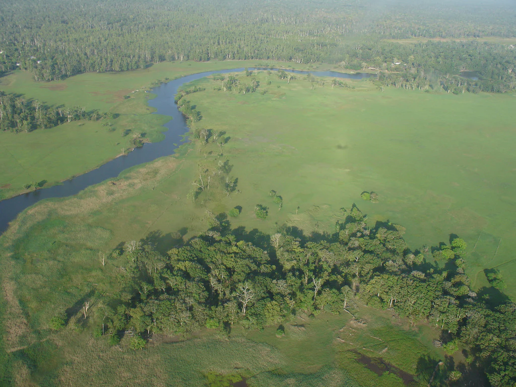
An aerial shot looking down over a winding river carving through vast, flat green savanna plains and clusters of dense forest.
Aerial view of the lush, winding wetlands and savanna plains in the Trans Fly region of Papua New Guinea.

Tonda Wildlife Management Area history and protected-area timeline

Tonda Wildlife Management Area was formally established in 1975, making it one of the older protected-area designations in Papua New Guinea. From the outset, the protection framework combined outside regulation with the realities of customary land ownership. The management area's rules restrict hunting by non-customary landowners, recognising that the country itself belongs to long-established local communities, including Kanum-speaking people in the western portion of the reserve.

In 1993, the site was listed as a wetland of international importance under the Ramsar Convention, drawing international attention to the global significance of the Trans-Fly floodplain. This was followed in 1995 by the launch of a Tri-National Wetlands Program by WWF, linking Tonda, Indonesia's Wasur National Park, and Australia's Kakadu National Park. The program created a long-running cooperation between the three countries' conservation agencies and culminated in an official Memorandum of Understanding in 2002.

By 2006, the area had been proposed for inclusion on the World Heritage list as part of the broader Trans-Fly Complex, recognising that the ecological value of Tonda cannot be separated from the wider wetland system that spans the international border with Indonesia.

Tonda Wildlife Management Area landscape and geographic character

Tonda's landscape is defined by flatness. Almost the entire management area sits below 45 metres elevation, and there are no significant ridgelines or uplands to interrupt the view. Instead, the terrain unfolds as a mosaic of wetland habitats that change character with the seasons and with proximity to the coast.

Along the southern edge, tidal river reaches give way to mangrove areas that mark the transition between freshwater floodplain and saltwater influence. Inland from the mangroves lie extensive freshwater swamps and low-lying grasslands, while further still, the land rises only barely into open savanna woodlands dotted with Acacia and Melaleuca trees. Small patches of denser monsoon forest break up the open country, particularly where soil conditions allow them to persist.

This low-relief mosaic is the defining scenic quality of Tonda: a wide, bright, often water-glazed plain where the boundary between land and water shifts with rainfall, tides and river flow. The result is a landscape that reads the same from the air as from the ground, and that depends on subtle gradients rather than dramatic landforms.

Tonda Wildlife Management Area ecosystems, habitats, and plant life

The ecosystems of Tonda range from estuarine to terrestrial in a very short horizontal distance. Mangrove forests fringe the tidal river channels along the coast, while freshwater swamps and reedbeds of Phragmites and Pseudoraphis extend inland wherever water collects. Away from these wetter zones, open grasslands and savanna woodlands, dominated by Acacia and Melaleuca, take over.

This vegetation pattern reflects the meeting of two ecological worlds: the tropical wetland systems of southern New Guinea and the drier savanna systems of the Trans-Fly region as a whole. The result is an unusually rich mosaic where aquatic, riparian and dry-country habitats occur side by side, allowing species from very different environments to coexist within a single protected landscape.

Biodiversity is correspondingly layered. The freshwater environments support rich fish communities, while the broader floodplain supports reptiles, mammals and birds adapted to seasonally wet grasslands and open woodland.

Tonda Wildlife Management Area wildlife and species highlights

Wildlife is the most prominent feature of Tonda's identity. The area is internationally important for over 250 species of resident and migratory waterbirds, which use the open plains and swamps as feeding, roosting and staging habitat during their annual movements. Tonda is especially significant for migratory shorebirds: most of the global population of little curlew is known to stage on the plains here during migration.

Beyond waterbirds, the management area supports brolga, several species of birds-of-paradise and a wide range of other birdlife associated with open savanna and monsoon forest patches. Reptiles include both saltwater crocodiles and New Guinea crocodiles, taking advantage of the area's mix of brackish and freshwater habitats.

Tonda is also notable for its mammal fauna, which includes around 50 species. Among them are several animals that are not found elsewhere in New Guinea, including the spectacled hare-wallaby, false water-rat, bronze quoll and chestnut dunnart. These species give Tonda a conservation importance that extends well beyond waterbirds, marking it as a refugium for fauna with strong biogeographic links to Australia.

Tonda Wildlife Management Area conservation status and protection priorities

Tonda has been Papua New Guinea's flagship wetland conservation site for nearly five decades. It was established as a Wildlife Management Area in 1975, and in 1993 it became the country's principal Ramsar-listed wetland, gaining international recognition for its ecological value. The Ramsar designation highlighted its role as a habitat for migratory waterbirds and as part of a broader wetland system that crosses international borders.

The site is central to a wider regional conservation cooperation. WWF's 1995 Tri-National Wetlands Program linked Tonda, Indonesia's Wasur National Park, and Australia's Kakadu National Park into a single conservation network, formalised in a 2002 Memorandum of Understanding between the three countries' conservation agencies. In 2006 the area was proposed for inclusion in the World Heritage list as part of the larger Trans-Fly Complex, underlining its significance at a global scale.

Conservation at Tonda operates within a complex land-tenure context. The land is under customary ownership, and the Wildlife Management Area rules restrict hunting by non-customary landowners rather than imposing uniform restrictions across the landscape. This approach reflects the practical reality that conservation here must work alongside, rather than apart from, the subsistence practices of local communities.

Tonda Wildlife Management Area cultural meaning and human context

Tonda is a working inhabited landscape as much as it is a protected area. Roughly 1,500 people live within its boundaries, organised into around twelve villages, and they depend on the floodplain for subsistence gardening and hunting. The western part of the management area covers traditional lands of the Kanum people, who are among the longest-established communities in this part of the Trans-Fly region.

This intersection of customary land tenure, subsistence livelihoods and international conservation designations gives Tonda a distinctive cultural dimension. The protection regime is built around the fact that the land is not state-owned, and the relevant regulations shape who may hunt and how, rather than excluding residents from the landscape. The result is a model in which local communities, customary landowners, national agencies and international conservation bodies all share responsibility for the future of the wetland.

Top sights and standout views in Tonda Wildlife Management Area

Tonda's strongest points of distinction lie in its combination of scale, wetland importance and trans-boundary ecological function. As Papua New Guinea's largest protected area, it covers nearly 6,000 square kilometres of essentially unbroken floodplain, providing habitat for over 250 waterbird species and serving as a critical staging area for migratory shorebirds such as the little curlew.

Equally distinctive is its position at the heart of the Trans-Fly savanna and grasslands ecoregion, directly contiguous with Indonesia's Wasur National Park. This cross-border continuity underpins the site's tri-national partnership with Kakadu National Park in Australia and turns Tonda into a regional anchor for wetland conservation in the southern hemisphere. Its customary-land governance model adds a further layer of distinction, showing that international conservation status can be sustained alongside long-standing indigenous land use.

Best time to visit Tonda Wildlife Management Area

Seasonality at Tonda is governed by the wet-dry pattern of southern New Guinea, which controls water levels, grass growth and bird activity across the floodplain. The dry season generally offers more accessible conditions across the savanna and grassland areas, when open plains attract concentrations of waterbirds and other wildlife and travel across the flat terrain becomes more practical.

The wet season transforms much of the landscape into extensive shallow wetland, swelling swamps and tidal reaches and intensifying the aquatic character of the area. This period can be particularly significant for waterbirds, though access becomes more constrained by flooding. Overall, the site's appeal depends heavily on timing relative to these seasonal swings rather than on any fixed calendar window.

Monthly climate preview

Examine long-term representative temperature ranges and monthly precipitation patterns across the landscape

Tonda Wildlife Management Area Climate Normals and Annual Weather Rhythm

Historical climate records for Tonda Wildlife Management Area document consistent thermal averages alongside marked shifts in monthly precipitation normals. Reviewing the comprehensive twelve-month dataset clarifies long-term meteorological trends across the protected coordinate point.
Annual mean27 °C
25 °C28 °C
Jan27°
Feb27°
Mar27°
Apr27°
May26°
Jun25°
Jul25°
Aug25°
Sep26°
Oct27°
Nov28°
Dec28°
Warmest month
November

28.3 °C

Coolest month
July

24.6 °C

Wettest month
February

10.7 mm/day

Driest month
September

0.6 mm/day

Park location guide

Geography guide, regional context, and park location map for Tonda Wildlife Management Area

Tonda Wildlife Management Area park geography, regions, and map view in Papua New Guinea

Understand where Tonda Wildlife Management Area sits in Papua New Guinea through a broader geographic reading of the surrounding landscape, nearby location context, and its mapped position within the national park landscape.

How Tonda Wildlife Management Area fits into Papua New Guinea

Papua New Guinea is an island nation in the southwestern Pacific Ocean, comprising the eastern half of the island of New Guinea and hundreds of offshore islands. It gained independence from Australia in 1975 and operates as a constitutional monarchy within the Commonwealth. The country is renowned for having the world's highest linguistic diversity, with over 840 known languages.

Wider geography shaping Tonda Wildlife Management Area in Papua New Guinea

Papua New Guinea occupies the eastern half of the island of New Guinea and hundreds of smaller islands in Melanesia. It shares a land border with Indonesia to the west and has maritime boundaries with Australia to the south and the Solomon Islands to the east. The terrain is predominantly mountainous, with the land supporting extraordinary biodiversity.

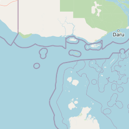
Map view of Tonda Wildlife Management Area

Use this park location map to pinpoint Tonda Wildlife Management Area in Papua New Guinea, understand its exact geographic position, and read its mapped placement within the surrounding landscape more clearly.

Pigeon | © OpenStreetMap contributors

Location context for Tonda Wildlife Management Area

Western Province

Visualizing lowland wetlands, savanna habitats, and protected terrain

Tonda Wildlife Management Area Photos and Landscape Scenery

Visual records capture the flat topography and wetland mosaic of Tonda Wildlife Management Area across changing seasonal floodwaters. Photographic evidence reveals the intricate transition zones between tidal rivers, mangrove belts, and open savanna woodlands.

An aerial shot looking down over a winding river carving through vast, flat green savanna plains and clusters of dense forest.

Park atlas

Compare connected wetland habitats and trans-border conservation areas across the region.

Other Parks Near Tonda Wildlife Management Area and Regional Protected Landscapes

Browsing other parks near Tonda Wildlife Management Area reveals wider regional patterns in lowland wetland and savanna geography. Comparing these adjacent protected landscapes provides essential context for understanding trans-border conservation corridors.
Protected areaQueensland
About 57 km away#1 closest

South

Warul Kawa Indigenous Protected Area: A Geographic Profile of a Remote Torres Strait Sand Cay

Protecting northern Australian reef platforms and marine habitats

Warul Kawa Indigenous Protected Area, or Deliverance Island, defines a unique landscape of sand cays and shallow algal reef platforms in the far north of Queensland. As a key site for flatback turtle breeding and migratory green turtles, the area offers a rare example of a near-pristine marine environment. Its geography highlights the intersection of Indigenous land management and high-integrity tropical island ecosystems.

Established
2001
Relief
Lowland
Climate
Tropical
Access
Remote access
National parkSouth Papua
About 58 km away#2 closest

Northwest

Wasur National Park National Park: Mapped Protected Boundaries in South Papua

Explore the geographic context and park boundaries.

Delve into the specific protected area identity of Wasur National Park, a national park situated within the South Papua region. This page offers detailed geographic context, focusing on its mapped boundaries and its significance as a protected landscape. It provides a factual basis for understanding the park's place within Indonesia's network of natural areas for structured atlas exploration.

Area
4,138 km²
Established
1990
IUCN
II
Visitors
2.3K annual
National parkAustralia
About 213 km away#3 closest

Southeast

Possession Island National Park: National Park Atlas and Mapped Geographic Context

Australia's protected natural terrain and park boundaries.

Possession Island National Park serves as a vital point of discovery for understanding Australia's protected lands. This national park provides detailed insights into its specific geographic setting and landscape character, contributing to a broader atlas of natural territories. Engage with its mapped boundaries and unique terrain to grasp its significance within the country's conservation landscape. It is an essential component for anyone exploring the geography of Australian national parks.

A wide watercolor illustration showing green hills in the distance, a body of shallow water with pink and green patches, and foreground vegetation including green grasses and pink coral-like structures.
Marine protected areaQueensland
About 216 km away#4 closest

Southeast

Great Barrier Reef Marine Park: Atlas and Geographic Context for Queensland Protected Waters

Exploring the reef system and marine conservation zones in northeastern Australia

The Great Barrier Reef Marine Park stands as an internationally significant marine protected area. By spanning a massive stretch of the Queensland coast, this protected landscape provides a critical framework for marine governance and reef conservation. Users can examine the unique zoning and distribution of coral reef habitats that define this extensive tropical ecosystem.

Area
343,966 km²
Established
1975
Climate
Tropical
Scope
Marine
Marine protected areaQueensland
About 221 km away#5 closest

South

West Cape York Marine Park: Atlas and Geographic Context for Queensland Marine Reserves

Protected marine habitats in the Gulf of Carpentaria

Examine the extensive marine landscape of West Cape York Marine Park, a key component of the North Marine Parks Network. This protected area features deep basin waters and productive shelf margins that serve as a transition zone between the Gulf of Carpentaria and the Torres Strait, safeguarding high biodiversity levels.

Area
16,012 km²
Established
2018
IUCN
IV
Relief
Lowland
National parkQueensland
About 280 km away#6 closest

Southeast

Apudthama National Park: Queensland National Park Protected Landscape Geography

Explore the mapped boundaries and regional context.

Apudthama National Park offers a distinct national park experience within Queensland, Australia, focusing on its protected area identity and geographic landscape. This entry provides critical atlas-level information, detailing the park's mapped boundaries and its position within the regional geography. Understand the specific natural terrain and conservation context of this significant protected land.

Area
2,370 km²
Established
1994
IUCN
II
Relief
Lowland
National parkAustralia
About 283 km away#7 closest

Southeast

Yamarrinh Wachangan Islands (Denham Group) National Park: Australian Protected Landscape Map and Geography

Mapped boundaries and regional geographic context within Australia.

This detail entry for Yamarrinh Wachangan Islands (Denham Group) National Park provides specific geographic context and atlas information for this Australian national park. It focuses on the protected landscape identity, mapped features, and regional setting, offering a factual foundation for understanding the park's place within Australia's protected areas network. Explore its unique geographic characteristics and its designation as a national park.

National parkQueensland
About 340 km away#8 closest

Southeast

Saunders Islands National Park: National Park Geography and Mapped Protected Landscape in Queensland

Explore the mapped terrain and protected area context.

Saunders Islands National Park represents a significant protected area within the geography of Queensland, Australia. This entry provides detailed atlas-level insights into its specific geographic boundaries and the nature of its protected landscape. Users can understand the park's regional placement and its mapped natural terrain, offering a concrete point for exploring Queensland's diverse protected lands and their unique environmental characteristics.

Area
0.19 km²
Established
1989
IUCN
II
Climate
Tropical

Common questions about visiting, size, designation, and location context for Tonda Wildlife Management Area

Tonda Wildlife Management Area FAQs for park facts, access, geography, and protected area context

Find quick answers about Tonda Wildlife Management Area, including protected-area facts, park geography, trail and visitor context, and how the park fits into its surrounding country and regional landscape.
MoriAtlas Explorer

Continue Your Protected Areas Search Across the Global Atlas

Deepen your exploration by continuing the structured search for national parks and protected areas worldwide. Utilize the comprehensive filtering capabilities to compare different conservation landscapes and refine your understanding of global park geography. Discover more about the distribution and characteristics of protected natural areas.

Global natural geography

