

Mori Atlas logo
Nature reserveTyagarah Nature Reserve

A vital stretch of undeveloped beach, dune systems, and endangered swamp sclerophyll forests on the Australian Pacific coast.

Tyagarah Nature Reserve: Mapping Coastal Conservation and Protected Landscapes in New South Wales

Tyagarah Nature Reserve preserves eight hundred seventy five hectares of coastal terrain between Byron Bay and Brunswick Heads in New South Wales. This protected landscape safeguards critical endangered ecological communities, including coastal saltmarsh and swamp sclerophyll forest, while serving as a recognized migration corridor for humpback whales. The reserve features an unbroken seven kilometer shoreline of dunes and estuarine fringes, deeply rooted in the traditional Country of the Arakwal people and the broader Bundjalung nation.

coastal reservebeachdune systemsendangered ecological communitiescoastal saltmarshswamp sclerophyll forest

Tyagarah Nature Reserve

Nature reserve

Park overview

Structured park overview, official facts, and landscape profile for Tyagarah Nature Reserve

Tyagarah Nature Reserve park facts, protected area profile, and essential visitor context

Review the core facts for Tyagarah Nature Reserve, including designation, size, terrain, visitor scale, habitats, and operating context in one park-focused overview.

About Tyagarah Nature Reserve

Tyagarah Nature Reserve is a coastal New South Wales nature reserve located in the Byron Shire of the Northern Rivers region, fronting the Tasman Sea between the resort town of Byron Bay to the south and the estuary town of Brunswick Heads to the north. The reserve stretches across roughly 875 hectares of land and roughly seven kilometres of beach and dune, creating a continuous barrier of protected coast that links the two population centres while keeping the shoreline free from the dense residential and commercial development that characterises much of the surrounding region. As one of the larger continuous blocks of undeveloped coast left in the Byron Shire, Tyagarah plays an important role in preserving the visual and ecological character of the Cape Byron coastline.

Ecologically, the reserve is unusually rich for its size. It contains several endangered ecological communities listed under New South Wales and federal frameworks, including coastal saltmarsh in the estuary and wetland margins and swamp sclerophyll forest on transitional lands between the beach and inland vegetation. The reserve also supports around three dozen threatened plant species, including species such as the stinking cryptocarya, red lilly pilly, and green-leaved rose walnut. This botanical richness is driven by the convergence of several habitat types within a short distance (ocean beach, dune heath, swampland, and lowland forest), which together produce a mosaic that few other coastal reserves in the region match.

Culturally, Tyagarah is the Country of the Bundjalung people, with particular spiritual and ancestral significance for the Arakwal, the traditional custodians of the land surrounding Cape Byron. The place name itself comes from the Yugambeh–Bundjalung language word 'Targourah', understood to mean 'open grass country' or 'camping ground', reflecting long Indigenous use of the area as an open, habitable stretch of coast. The reserve is also known for its marine megafauna: humpback whales migrate past its shoreline each year, making Tyagarah Beach one of the more accessible and consistent land-based whale watching spots on Australia's east coast, especially in spring when mothers with new calves move south.

There is also a strong social layer to Tyagarah's identity. For decades the main beach within the reserve, also called Tyagarah Beach, operated as one of Australia's few formally recognised clothing-optional beaches. It became a sanctuary and social hub for naturists and LGBTQIA+ communities and a symbol of the Byron region's alternative and countercultural character, until that designation was removed in 2024 following complaints about behaviour and broader shifts in the social climate of the area.

Quick facts and research context for Tyagarah Nature Reserve

Tyagarah Nature Reserve is a New South Wales nature reserve located in the Northern Rivers region between Byron Bay and Brunswick Heads, totalling about 875 hectares and fronting roughly seven kilometres of beach. It protects multiple endangered ecological communities, including coastal saltmarsh and swamp sclerophyll forest, and is habitat for around three dozen threatened plant species. The reserve is recognised as one of the most reliable land-based whale watching locations on the NSW north coast, especially during the southbound humpback migration in austral spring. The reserve is on Bundjalung Country and holds particular spiritual and cultural significance for the Arakwal people.

Protection and recognition

Examine the terrestrial protection scope and documented designation history for Tyagarah Nature Reserve.

Tyagarah Nature Reserve Protection Status and International Recognition Data

Tyagarah Nature Reserve maintains a defined terrestrial protection scope within the regional conservation network. Structured records outline the formal designation framework and administrative history associated with the protected area.

Protection details

Protection scope
Terrestrial
Transboundary protection
No
Park context

Deeper park guide and search-rich context for Tyagarah Nature Reserve

Tyagarah Nature Reserve history, landscape, wildlife, and travel context

Explore Tyagarah Nature Reserve through its history, landscape character, ecosystems, wildlife, conservation priorities, cultural context, and seasonal travel timing in a structured park guide built for atlas discovery and search intent.

Why Tyagarah Nature Reserve stands out

The reserve is most famous for two distinct things: a high-quality and easily accessible land-based vantage point for the annual humpback whale migration along Australia's east coast, and a remarkable concentration of threatened plant species and endangered coastal ecological communities packed into a relatively compact coastal reserve. It also became well known as the site of Tyagarah Beach, a long-standing clothing-optional beach with deep cultural significance for naturist and LGBTQIA+ communities in the Byron Shire. That combination of marine megafauna spectacle, fragile coastal habitat, and a layered social history gives Tyagarah an unusually broad identity for a relatively small reserve.
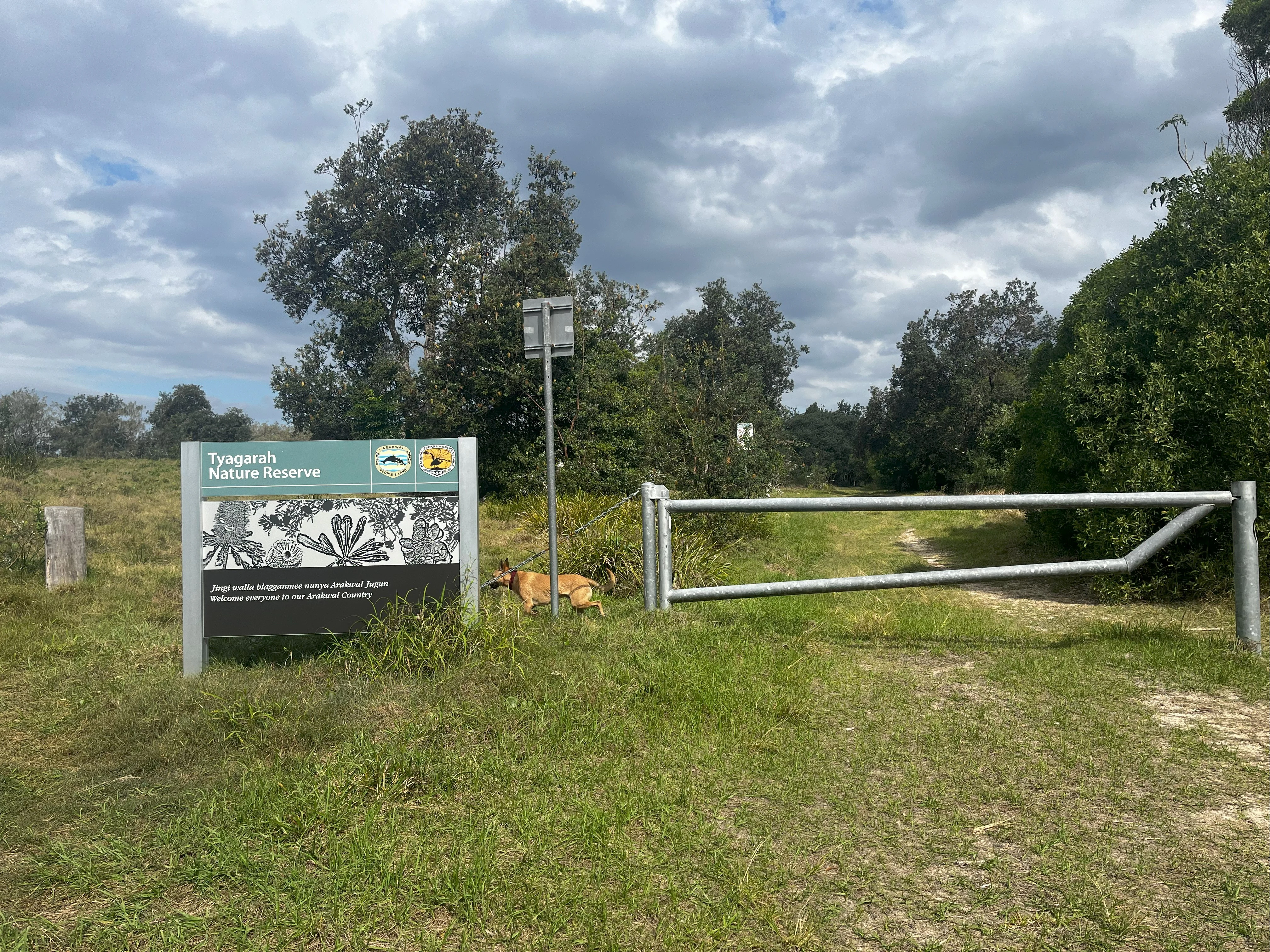
A green and white information sign for Tyagarah Nature Reserve next to a metal vehicle barrier gate on a grassy path.
The entrance sign and gate to Tyagarah Nature Reserve in New South Wales.

Tyagarah Nature Reserve history and protected-area timeline

The lands of the Tyagarah Nature Reserve have a much deeper Indigenous history than their formal reserve status suggests. The beach and dune systems, estuarine flats, and open grassy hinterland were used and managed for generations by the Bundjalung people. Within that broader cultural region, the Arakwal people hold a particular connection to the area around Cape Byron and the Tyagarah coastline, which they consider spiritually significant. The Bundjalung word 'Targourah', meaning open grass country or camping ground, reflects this long-standing human relationship with the landscape.

In colonial and modern records, Tyagarah Beach appears as early as 1902, when a man was reportedly arrested and imprisoned for swimming there naked, an early written indication that the beach was already being used informally without clothing long before any formal recognition of that practice. For much of the twentieth century the beach remained a remote, lightly visited stretch of coast used by locals, naturists, and free-spirited travellers drawn to the broader Byron Bay countercultural scene.

In 1998, the Byron Shire formally designated Tyagarah Beach as a clothing-optional beach, formalising a practice that had existed informally for decades. The designation attracted a regular community of naturists and LGBTQIA+ visitors, who came to see the beach as a sanctuary symbolising freedom and belonging. The reserve's modern legal protection and ecological significance were also recognised and expanded across the late twentieth and early twenty-first centuries, including the documentation of multiple endangered ecological communities and threatened plant species on its lands.

From 2018 onward, the clothing-optional status of Tyagarah Beach became contested. Protests such as those under the banner 'Nude Not Lewd' argued against what some residents and commentators described as a broader shift toward conservative attitudes in the region. This debate culminated on 30 August 2024, when the Byron Shire removed the clothing-optional designation from the beach following complaints about inappropriate behaviour. No alternative beach within the reserve was given the same status, marking a significant change in the social character of one of Australia's most recognisable naturist beaches.

Tyagarah Nature Reserve landscape and geographic character

Tyagarah Nature Reserve spans a representative stretch of the NSW far-north coast, defined by an unbroken arc of sandy beach backed by a layered system of dunes, swamplands, and low coastal forest. The reserve's shoreline runs for roughly seven kilometres along the Pacific, sitting just north of the Byron Bay headland and south of the Brunswick River estuary. This stretch of coast remains largely free of residential development and seawalls, allowing the beach profile, dune line, and frontal vegetation to maintain more or less natural dynamics.

Behind the beach, a mosaic of terrestrial habitats unfolds across the reserve's full 875 hectares. Old frontal dunes give way to more stable hind-dune scrublands, which in turn transition into low-lying wetland areas fed by minor creeks and tidal influence near the Brunswick River end of the reserve. These coastal swamplands and estuarine fringes are among the most ecologically significant parts of the reserve, supporting the coastal saltmarsh communities that are listed as endangered. Further inland, the vegetation shifts into swamp sclerophyll forest, a damp eucalypt-dominated woodland that thrives on transitional soils between wetland and dry land.

The combination of elements gives Tyagarah its distinctive scenic character: a sweeping ocean horizon on one side, a wall of scrambling wind-formed dunes in the middle distance, and a backdrop of paperbark-fringed swampland and forested ridgelines. From elevated sections of the reserve, viewers can take in long arcs of coast and, in season, the offshore silhouettes of humpback whales travelling through the migration corridor, a flat, oceanic view that distinguishes Tyagarah from the more enclosed hinterland reserves of the Northern Rivers.

Tyagarah Nature Reserve ecosystems, habitats, and plant life

Ecologically, Tyagarah Nature Reserve functions as a compact laboratory of the NSW north coast's coastal ecosystems. Although it is modest in size at 875 hectares, it captures a remarkable range of vegetation types across a short distance, including beach strand, fore-dune heath, hind-dune scrub, coastal swampland, estuarine saltmarsh, and swamp sclerophyll forest. This transition across habitats inside a single reserve is one of its defining ecological qualities.

The reserve protects at least six endangered ecological communities recognised under New South Wales and Commonwealth environmental frameworks. Among them, coastal saltmarsh stands out as a particularly threatened vegetation type across eastern Australia, restricted to narrow tidal margins at the Brunswick River end of the reserve. Swamp sclerophyll forest, another listed community, occupies transitional zones where freshwater influences mix with the coastal setting. Together, these communities support a disproportionately high level of botanical diversity relative to the reserve's footprint.

The mosaic of habitats also provides continuity of vegetation cover between the heavily developed Byron Bay urban area and the more rural lands around Brunswick Heads. This continuity matters because many of the threatened species found inside the reserve depend on intact patches of native vegetation connecting coastal and inland habitat. The reserve therefore functions as both a refuge and a stepping-stone within the broader ecological corridor of the Cape Byron hinterland.

Tyagarah Nature Reserve wildlife and species highlights

Tyagarah's most visible and celebrated wildlife story is the annual passage of humpback whales along the east Australian migration corridor. Each year, large numbers of humpback whales travel north from Antarctic feeding grounds toward calving areas around the Great Barrier Reef, and return south in spring with their newborn calves. The reserve's open beaches, lack of major headland obstructions, and clear sightlines to the ocean make it a favoured land-based vantage point. Mothers with calves, often travelling slowly and close to shore in spring, are particularly commonly seen from Tyagarah Beach.

Beyond the marine megafauna, the reserve's flora is among the most botanically notable features of its wildlife profile. Roughly 33 threatened plant species are recorded as occurring or likely to occur within the reserve. These include the stinking cryptocarya, a small rainforest tree with a distinctive aroma; the red lilly pilly, a coastal rainforest species; and the green-leaved rose walnut, another rainforest tree of conservation concern. Together they reflect the reserve's role in preserving lowland coastal rainforest and sclerophyll flora that has been heavily reduced elsewhere in the region.

The reserve's wetland and forest habitats also support a wide range of birdlife typical of NSW coastal reserves, including shorebirds along the beach and estuarine margins, honeyeaters and lorikeets in the flowering heath and forest edges, and more secretive wetland species within the swamp sclerophyll forest and saltmarsh zones. Estuarine sections are additionally habitat for fish, crustaceans, and other marine invertebrates that underpin shorebird feeding during migration seasons.

Tyagarah Nature Reserve conservation status and protection priorities

Tyagarah Nature Reserve is one of the most ecologically significant reserves in the Byron Shire because it preserves multiple threatened ecological communities in essentially their natural state within a region that has experienced heavy coastal development. The protection of coastal saltmarsh and swamp sclerophyll forest within the reserve is especially important, as both of these communities have declined substantially elsewhere along the NSW coast due to urbanisation, drainage, and grazing pressure. By keeping these communities intact and connected to the beach and dune systems, Tyagarah contributes to the regional survival of vegetation types that no longer have many secure homes.

The reserve's role in protecting threatened plant species is also disproportionate to its size. With around 33 threatened plant species recorded, including rainfall-dependent rainforest trees such as the stinking cryptocarya, red lilly pilly, and green-leaved rose walnut, the reserve effectively functions as a conservation refuge for flora that has been heavily reduced elsewhere in lowland eastern Australia. The mosaic of habitats also supports the ecological processes, fire regimes, and hydrological patterns on which these species depend.

In a broader sense, Tyagarah is a key component of the protected-area network that buffers the Byron Bay region. By holding seven kilometres of undeveloped coastline and a continuous corridor of native vegetation between Byron Bay and Brunswick Heads, the reserve reduces habitat fragmentation, supports wildlife movement, and maintains water quality in the Brunswick River estuary. Its conservation value is therefore both site-specific, in terms of its ecological communities and species, and landscape-scale, in terms of how it anchors the ecological character of the Cape Byron coastline.

Tyagarah Nature Reserve cultural meaning and human context

The cultural landscape of Tyagarah Nature Reserve is shaped primarily by the long-standing Indigenous custodianship of the Bundjalung people, with a particular connection held by the Arakwal, whose traditional lands include the Cape Byron area and extend along the Tyagarah coast. For the Arakwal, the reserve holds strong spiritual and cultural significance, intersecting with dreaming tracks, traditional use sites, and continuing cultural responsibilities along the shoreline and estuarine flats.

The name 'Tyagarah' itself reflects this deep Indigenous heritage, derived from the Yugambeh–Bundjalung word 'Targourah', meaning 'open grass country' or 'camping ground'. The phrase captures how the landscape was understood and used: as an open, habitable stretch of coast suited to gathering, camping, and movement between resource areas. The persistence of the Bundjalung place name on the modern reserve is a direct continuation of Indigenous toponymy in a region where many European-era names have displaced older names.

In more recent decades, the reserve has also developed a distinctive non-Indigenous cultural layer. From the late twentieth century onward, Tyagarah Beach became a recognised clothing-optional beach and a sanctuary for naturists and LGBTQIA+ communities, representing an inclusive and countercultural strand of the Byron Shire's identity. The 2024 removal of the clothing-optional designation, following years of debate and protest, marked a turning point in the beach's social history and is part of the ongoing story of how the reserve's multiple cultural meanings (Indigenous, naturist, and conservation-oriented) coexist and sometimes collide.

Top sights and standout views in Tyagarah Nature Reserve

Tyagarah Nature Reserve concentrates several of eastern Australia's most distinctive coastal experiences into one relatively small, accessible site. Among its strongest points of distinction are the seven kilometres of largely undeveloped beach between Byron Bay and Brunswick Heads, the endangered coastal saltmarsh and swamp sclerophyll forest communities found within its 875 hectares, and the roughly 33 threatened plant species recorded across its mosaic of habitats.

A standout experience is watching humpback whales, especially mothers and calves, from the reserve's shoreline during the spring southern migration, often regarded as one of the most reliable land-based whale watching opportunities on the NSW coast. Equally notable is the cultural depth of the site, from Bundjalung and Arakwal custodianship and the Yugambeh–Bundjalung origin of the name itself to the reserve's later role as a long-standing naturist and LGBTQIA+ sanctuary. These layered natural and cultural identities are what set Tyagarah apart from more uniformly nature-focused coastal reserves in the region.

Best time to visit Tyagarah Nature Reserve

The most rewarding time to visit Tyagarah Nature Reserve for many visitors is during the austral spring months, when humpback whales are actively moving south along the coast toward Antarctic waters. Mothers and calves in particular tend to swim close to shore during this part of the migration, often producing some of the most memorable sightings from the reserve's beaches. Spring also coincides with milder temperatures and lower humidity than the peak of summer, making beach walking and dune exploration more comfortable.

Late summer and early autumn bring warmer ocean conditions and a different ecological character, with flowering shrubs in the dune heath and sclerophyll forest attracting honeyeaters, lorikeets, and other nectar-feeding birds. Winter visits tend to be quieter and cooler, with clearer ocean visibility but reduced whale activity; cooler months can still be rewarding for botanists and birdwatchers interested in lowland rainforest and swamp sclerophyll species. Many of the reserve's threatened plant features and ecological communities are best appreciated when vegetation is actively growing, so visits in the warmer half of the year often reveal more of the reserve's botanical richness.

Monthly climate preview

Trace long-term representative temperature and monthly precipitation averages across the reserve.

Tyagarah Nature Reserve Climate Normals and Annual Temperature Rhythm

Historical climate records for Tyagarah Nature Reserve reveal steady monthly temperature variations alongside recorded precipitation rates measured across a representative coordinate. Reviewing the complete twelve-month normals profile offers deeper insight into long-term thermal rhythms and moisture patterns.
Annual mean21 °C
18 °C25 °C
Jan25°
Feb25°
Mar24°
Apr23°
May21°
Jun19°
Jul18°
Aug18°
Sep20°
Oct21°
Nov22°
Dec24°
Warmest month
February

24.8 °C

Coolest month
July

17.8 °C

Wettest month
February

5.9 mm/day

Driest month
September

1.3 mm/day

Park location guide

Geography guide, regional context, and park location map for Tyagarah Nature Reserve

Tyagarah Nature Reserve park geography, regions, and map view in Australia

Understand where Tyagarah Nature Reserve sits in Australia through a broader geographic reading of the surrounding landscape, nearby location context, and its mapped position within the national park landscape.

How Tyagarah Nature Reserve fits into Australia

Australia is a constitutional monarchy and federal parliamentary democracy comprising six states and ten territories. With a population of nearly 28 million, it is one of the world's most urbanised countries, with most people concentrated on the eastern seaboard. The country has a high Human Development Index and is known for its cultural diversity, ancient Aboriginal heritage, and unique wildlife.

Wider geography shaping Tyagarah Nature Reserve in Australia

Australia occupies the entire Australian continent, the island of Tasmania, and numerous smaller islands. It is the world's flattest and driest inhabited continent, featuring vast deserts in the interior (the Outback), tropical rainforests along the eastern coast, and a coastline bordering the Indian and Pacific Oceans.

Map view of Tyagarah Nature Reserve

Use this park location map to pinpoint Tyagarah Nature Reserve in Australia, understand its exact geographic position, and read its mapped placement within the surrounding landscape more clearly.

Pigeon | © OpenStreetMap contributors

Location context for Tyagarah Nature Reserve

New South Wales

Explore protected coastal habitats, dune systems, and marine migration viewpoints.

Tyagarah Nature Reserve Photos and Landscape Scenery Visual Guide

Visual documentation captures the unbroken sandy beaches, wind-formed dunes, and endangered coastal saltmarsh communities defining Tyagarah Nature Reserve. Photographic records reveal the varied terrain and protected landscape character supporting rare plant species along the northern New South Wales coastline.

A green and white information sign for Tyagarah Nature Reserve next to a metal vehicle barrier gate on a grassy path.

Park atlas

Compare regional protected areas and connected coastal ecosystems across New South Wales

Exploring Parks Near Tyagarah Nature Reserve And Protected Coastal Landscapes

Continue geographic comparison by browsing other protected areas and reserves situated near Tyagarah Nature Reserve. Evaluating adjacent coastal landscapes provides deeper context into regional biodiversity and shared dune habitats.
Nature reserveNew South Wales
About 5.3 km away#1 closest

East

Nguthungulli Julian Rocks Nature Reserve: Atlas of Coastal Protected Marine Landscapes

Geographic overview of basalt islands and Tasman Sea marine environments.

Nguthungulli Julian Rocks Nature Reserve represents a rare convergence of marine geography off the coast of New South Wales. These two rocky islets provide a dense, structured habitat where warm and cool currents meet. The reserve acts as a focal point for understanding regional coastal conservation, Indigenous cultural heritage, and the intricate, submerged basalt formations that define this significant Australian protected area.

Area
40.47 km²
Established
1961
IUCN
Ia
Relief
Lowland
National parkNew South Wales
About 6.5 km away#2 closest

Southeast

Arakwal National Park: National Park Protected Landscape in New South Wales

Explore mapped boundaries and regional geography.

Arakwal National Park stands as a protected national park, offering insights into its distinct landscape and geographic setting within New South Wales. This resource provides detailed information focused on the park's mapped boundaries and its role as a conservation landscape. Users can explore the regional geography and understand the specific protected-area context that defines Arakwal National Park, contributing to a broader atlas understanding.

Area
1.99 km²
Established
2001
IUCN
II
Relief
Lowland
Nature reserveNew South Wales
About 7.4 km away#3 closest

South

Hayters Hill Nature Reserve: A Significant Big Scrub Rainforest Remnant in New South Wales

Protected subtropical forest in the Northern Rivers hinterland

Hayters Hill Nature Reserve represents a critical protected fragment of the original Big Scrub subtropical rainforests. Situated on elevated ground near Byron Bay, this nature reserve offers insight into the regional topography and the conservation of lowland forest ecosystems in the Northern Rivers area of New South Wales.

Area
0.08 km²
Established
1989
IUCN
IV
Relief
Upland
Nature reserveNew South Wales
About 8 km away#4 closest

North

Brunswick Heads Nature Reserve: Protected Littoral Rainforest and Coastal Geography

Northern Rivers coastal terrain and protected ecosystem mapping

Spanning 221 hectares, Brunswick Heads Nature Reserve protects one of the few remaining littoral rainforest stands in New South Wales. The reserve features a dense, sheltered rainforest interior that contrasts with open sandy beaches and tidal estuarine flats, creating a high-density habitat mosaic for rare plants and threatened shorebird populations.

Area
2.21 km²
Established
1979
IUCN
IV
Relief
Lowland
A stylized illustration showing a sandy beach meeting the ocean, flanked by grassy green hills and cliffs under a soft-colored sky.
Nature reserveNew South Wales
About 13 km away#5 closest

South

Broken Head Nature Reserve: Littoral Rainforest and Coastal Geography of New South Wales

Coastal terrain and protected headland mapped landscapes

Located in the Northern Rivers region of New South Wales, Broken Head Nature Reserve offers a concentrated view of coastal ecological zones. The protected area features a unique combination of littoral rainforest, sandstone formations, and beach ecosystems. This geography provides insight into regional conservation and the historical landscape of the far north coast of Australia.

Area
0.98 km²
IUCN
Ia
Relief
Lowland
Climate
Subtropical
Marine protected areaNew South Wales
About 13 km away#6 closest

Southeast

Cape Byron Marine Park: Protected Marine Geography and Coastal Landscapes in New South Wales

Subtropical marine sanctuary and reef biodiversity atlas

Spanning from the Brunswick River to Lennox Head, Cape Byron Marine Park serves as a vital protected area on the Australian east coast. Analyze its coastal geography, including tidal estuaries, sandy surf beaches, and significant submerged reef structures that support a convergence of subtropical and temperate marine life.

Area
220 km²
Established
2002
Relief
Lowland
Climate
Subtropical
National parkNew South Wales
About 15 km away#7 closest

Northwest

Mount Jerusalem National Park: Ancient Volcanic Terrain and Protected Landscape Discovery in New South Wales

Explore its mapped geography and Albert's lyrebird habitat.

Mount Jerusalem National Park stands as a key protected area within the dramatic landscape of New South Wales. Situated on the eroded outer rim of the ancient Tweed Caldera, the park showcases distinctive volcanic terrain shaped over millions of years. Its protected boundaries encompass vital habitats, notably supporting significant populations of Albert's lyrebird, and contribute to the watershed dynamics of the Tweed, Brunswick, and Richmond River systems, offering a rich focus for geographic and landscape exploration.

Area
52 km²
Established
1995
IUCN
II
Relief
Mountain
National parkNew South Wales
About 16 km away#8 closest

West

Goonengerry National Park: New South Wales Protected Landscape and Geography

Discover mapped boundaries and regional context.

Goonengerry National Park is a designated national park in New South Wales, Australia, offering valuable insights for geographic exploration. This entry provides a structured view of its protected area status, focusing on its mapped boundaries and landscape context. Users can explore how Goonengerry National Park fits into the regional geography of New South Wales, enhancing understanding of protected lands within the Australian atlas.

Area
4 km²
Established
1999
IUCN
II
Relief
Upland

Common questions about visiting, size, designation, and location context for Tyagarah Nature Reserve

Tyagarah Nature Reserve FAQs for park facts, access, geography, and protected area context

Find quick answers about Tyagarah Nature Reserve, including protected-area facts, park geography, trail and visitor context, and how the park fits into its surrounding country and regional landscape.
MoriAtlas Explorer

Continue Your Protected Areas Search Across the Global Atlas

Deepen your exploration by continuing the structured search for national parks and protected areas worldwide. Utilize the comprehensive filtering capabilities to compare different conservation landscapes and refine your understanding of global park geography. Discover more about the distribution and characteristics of protected natural areas.

Global natural geography