
Mori Atlas logo
Nature reserveV hrobech

A study of rare thermophilic flora and managed meadow terrain in an urban context

V hrobech Nature Reserve: Mapping the Protected Grassland Landscapes of Southern Prague

(Přírodní památka V hrobech)

V hrobech is a protected nature reserve in Prague, encompassing a unique fragment of acidic dry-grassland and southeast-facing slopes. This site preserves rare botanical species such as the Bohemian pasqueflower and Bohemian star-of-Bethlehem within a densely urbanized environment. Through active management and mosaic mowing, the monument maintains its distinct habitat character against the surrounding cityscape, serving as a critical refuge for specialized plant communities in the Kamýk area.

dry grasslandurban nature reservethermophilic floraPrague protected areasmall natural monumentmeadow management
A flat-design vector illustration of a scenic valley with a sun in the sky, rocky mountains in the background, a small waterfall, a pine forest, and deciduous trees in the foreground with a trail path.

V hrobech

Nature reserve

Park overview

Structured park overview, official facts, and landscape profile for V hrobech

V hrobech park facts, protected area profile, and essential visitor context

Review the core facts for V hrobech, including designation, size, terrain, visitor scale, habitats, and operating context in one park-focused overview.

About V hrobech

V hrobech occupies a modest but ecologically distinctive position among Prague's protected natural areas. The natural monument lies on a southeast-facing slope in the Kamýk district of Prague 4, squeezed between three large residential housing estates and the office of the Czech Hydrometeorological Institute. Although only about 1.3 hectares in size, it carries disproportionate botanical importance because it preserves remnants of dry, nutrient-poor grassland that once extended more widely across the warmer slopes south of Prague.

The protected area is essentially a former pasture that was historically embedded in a wider network of fields, meadows, and the Kamýk forest park. A small watercourse ran along its northwestern edge, feeding wetland vegetation and supporting threatened species. By the 1960s, the locality was already noted by botanists for its thermophilic flora, though the activities of amateur plant collectors and, later, expanding housing development significantly reduced many of its original populations.

Today, V hrobech is managed as a controlled reserve, meaning that active human intervention is required to maintain its open character. The site is maintained through regular mosaic mowing combined with grazing, with future plans to incorporate controlled burning as a traditional third tool for dry-grassland management. The natural monument functions as a small but valuable refuge of dry-grassland and meadow habitats in a heavily urbanized setting, and together with the adjacent Kamýk forest park it forms part of a local ecological network supporting insects, birds, and small mammals.

Quick facts and research context for V hrobech

V hrobech is a Prague natural monument declared on 1 September 1988 by the National Committee of the City of Prague, covering approximately 1.3 hectares at 276 to 282 meters above sea level. It lies in the Kamýk cadastral area of Prague 4, bordered by the Lhotka, Libuš, and Modřany housing estates. The site is administered by the Agency for Nature Conservation and Landscape Protection of the Czech Republic and is classified as a managed reserve requiring active intervention to maintain its grassland character. Geologically, it sits on nutrient-poor Lower Ordovician shales from the Paleozoic era, roughly 550 million years old, with shallow ranker soils and cambisols.

Protection and recognition

Review documented terrestrial protection metrics and official designation records for V hrobech.

V hrobech Protection Status and Documented Conservation Scope

Terrestrial protection status and formal conservation metrics for V hrobech are compiled directly from verified records. Documented management scope and baseline geographic data provide a reliable framework for analyzing regional conservation commitments.

Protection details

Protection scope
Terrestrial
Transboundary protection
No
Park context

Deeper park guide and search-rich context for V hrobech

V hrobech history, landscape, wildlife, and travel context

Explore V hrobech through its history, landscape character, ecosystems, wildlife, conservation priorities, cultural context, and seasonal travel timing in a structured park guide built for atlas discovery and search intent.

Why V hrobech stands out

V hrobech is best known for its unusually rich dry-grassland flora surviving in a dense urban environment in southern Prague. The hillside preserves fragments of the Koelerio-Phleion phleoidis acidic dry-grassland community, hosting rare thermophilic species such as Pulsatilla pratensis subsp. bohemica and Gagea bohemica, alongside historical records of critically endangered plants like Daphne cneorum. It is also recognized as an important example of how active management, including mosaic mowing and grazing, is used to combat invasive meadow grasses in a small, city-fragmented habitat.
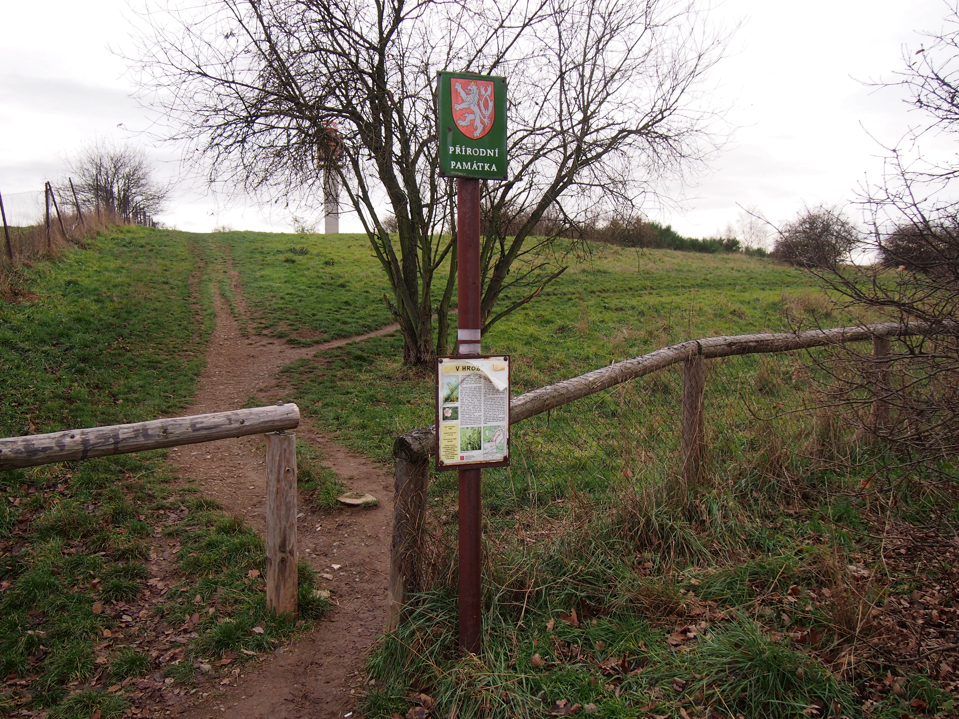
A signpost for the V hrobech natural monument in Czechia, featuring a national emblem at the top and an information board below, situated at the entrance of a grassy trail with wooden fencing.
Information sign marking the entrance to the V hrobech natural monument.

V hrobech history and protected-area timeline

V hrobech was officially declared a natural monument on 1 September 1988 by the National Committee of the City of Prague, formalizing protection for a pasture of considerable botanical interest that had already been recognized by botanists and amateur plant enthusiasts since at least the 1960s. Before its declaration, the area was an actively used pasture surrounded by fields and meadows, with the Kamýk forest park lying nearby and a small stream along its northwestern margin supporting patches of wetland vegetation and threatened species.

Over the second half of the twentieth century, the area experienced multiple pressures. Amateur plant collectors removed many rare species from the locality, reducing once-significant populations to very small remnants or eliminating them entirely. The construction of large panel-style housing estates in adjacent neighborhoods, along with associated earthworks, damaged and in places destroyed the marginal parts of the site. Increased recreational use, particularly by dog walkers with unleashed pets, further altered the ecological character of the site and contributed to rising eutrophication.

Two formal management plans have guided the site. The first plan covered the period 2002 to 2011, and a second plan was issued in October 2011 for the period 2012 to 2021. Scientific surveys include a floristic inventory conducted between 1976 and 1980 and repeated in 1993 and 1998, a butterfly survey in 1986 to 1987, and a comprehensive inventory in 2007 that unexpectedly recorded a clump of Stipa pennata. A supplementary botanical survey was carried out in 2009 and 2010 to support the new management plan.

V hrobech landscape and geographic character

V hrobech has the character of a small, warm, southeast-facing slope descending into a shallow valley, set within the otherwise flat to gently rolling terrain of southern Prague. The protected area lies at an elevation of about 276 to 282 meters above sea level and is built on nutrient-poor Lower Ordovician shales from the Paleozoic era, roughly 550 million years old. Soils are predominantly shallow rankers, with some cambisols on parts of the slope.

The site's topography creates a clear ecological gradient. The upper and southern portions form a sun-exposed, drier hillside with shallow soils over weathered shale bedrock, while the northwestern part of the natural monument slopes down toward a small valley where an intermittent stream, a left-bank tributary of Lhotecký potok, once supported wetland vegetation. Today, this valley edge is partly lined with shrubs and reed-like wetland plants, and the boundary of the protected area is marked by a shrubby belt of roses, apple trees, walnuts, false acacia, mahaleb cherries, oaks, maple, linden, privet, snowberry, dogwood, and bird cherry.

Outside the protected perimeter, the landscape is strongly urban. The Kamýk housing estate's panel buildings rise immediately along parts of the boundary, the grounds of the Czech Hydrometeorological Institute are visible from the southeastern slope, and a mixed-use cycling path runs along the edge of the site, passing near a softball club area and the remains of an abandoned BMX track. Together, these features give V hrobech the distinctive character of a tiny semi-natural island within a dense cityscape.
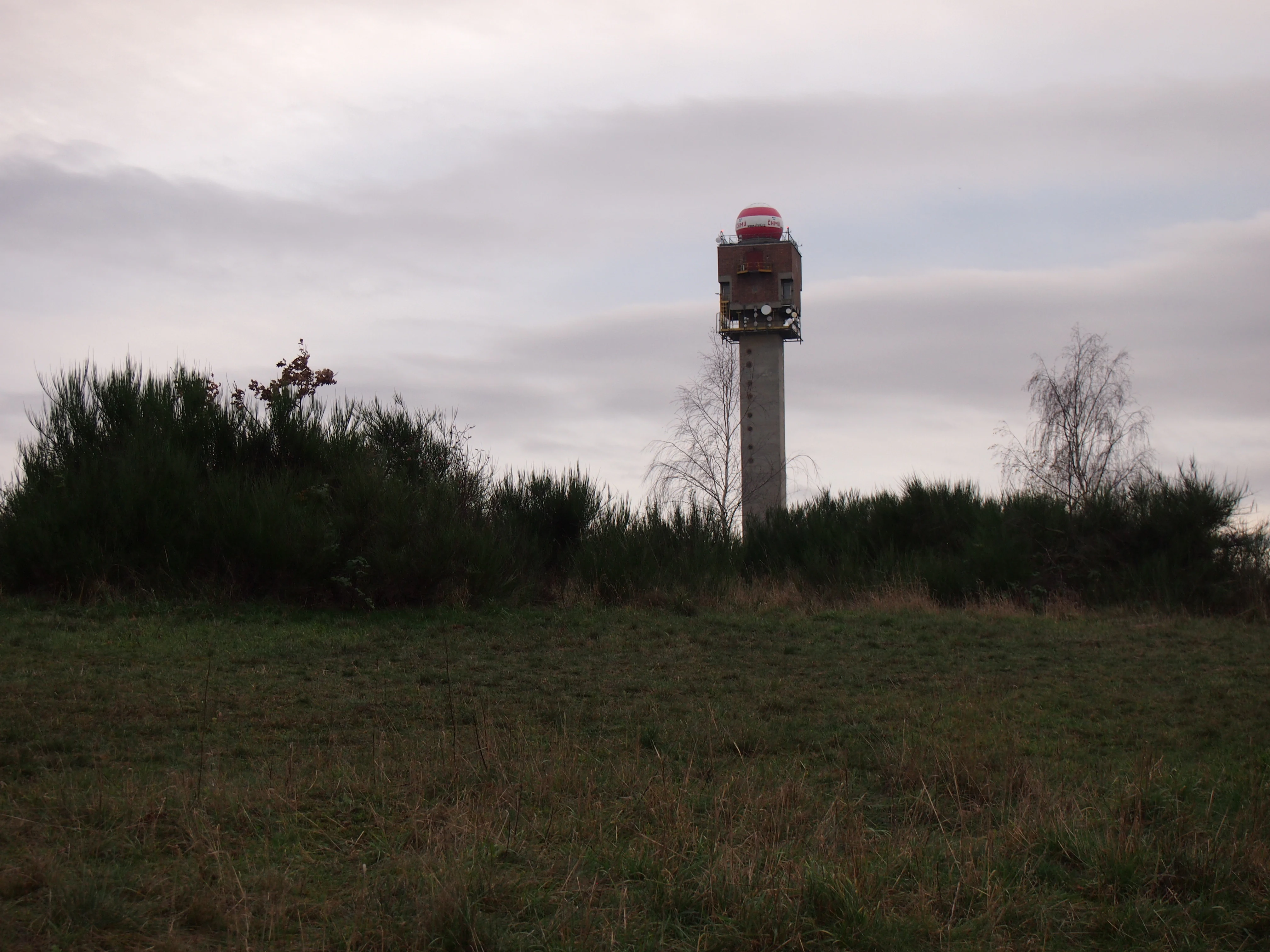
A tall, industrial-looking hydrometeorological tower with a red and white dome stands in the distance behind a line of dense bushes and a grassy field.
Hydrometeorological station at the V hrobech nature reserve.

V hrobech ecosystems, habitats, and plant life

Despite its compact size, V hrobech preserves a striking mosaic of habitats that includes dry acidic grasslands, mesophilous meadows, small patches of heath, wetland fringes, and scrub. The site's core ecological value lies in fragments of the Koelerio-Phleion phleoidis community (Koelerio-Phleion phleoidis), an acidic dry-grassland type, which supports the majority of its rare plant species. A small area of Calluno-Genistion heath vegetation adds to the habitat diversity.

The flora is exceptionally rich for such a small urban site. Historically documented species include Daphne cneorum (lýkovec vonný), Rosa gallica (růže galská), and Orchis morio (vstavač kukačka). Currently confirmed flagship species include Pulsatilla pratensis subsp. bohemica (koniklec luční český), Gagea bohemica (křivatec český), Armeria vulgaris, and Veronica spicata. The mesophilous meadows of the central portion of the site are dominated by Arrhenatherum elatius (ovsík vyvýšený), while dry-grassland areas feature species such as Potentilla arenaria, Helianthemum grandiflorum subsp. obscurum, Trifolium alpestre, Festuca rupicola, Thymus praecox, Dianthus carthusianorum, and Hieracium pilosella.

Wetland vegetation along the intermittent stream at the western margin includes species such as Scirpus sylvaticus, Iris pseudacorus, Salix caprea, and Filipendula ulmaria. A scrub belt and shrubby patches support roses (Rosa sp.), Fraxinus excelsior, Betula pendula, Sambucus nigra, and larger stands of Sarothamnus scoparius (janovec metlatý), contributing vertical structure and additional habitat niches within the natural monument.

V hrobech wildlife and species highlights

V hrobech supports a community of invertebrates that is closely tied to its herbaceous vegetation. Various bumblebees and other Hymenoptera are present, along with butterflies such as Melanargia galathea, Gonepteryx rhamni, and Eriocrania unimaculella. The notable protected butterfly Papilio machaon (otakárek fenyklový) has also been recorded here. Although the site is not a primary stronghold for butterflies, it functions as a stepping stone where species from surrounding habitats occasionally occur. Phytophagous beetles, including weevils (Nosatcovití) and leaf beetles (Mandelinkovití), are also present.

Birds form the most visible faunal group. In past decades, the site supported ground-nesting species such as Alauda arvensis (skřivan polní) and Phasianus colchicus (bažant obecný), as well as shrub-nesting species including Turdus merula (kos černý), Emberiza citrinella (strnad obecný), and Lanius collurio (ťuhýk obecný). Increased disturbance has reduced the breeding bird community, and today many birds use the site mainly for feeding or as fly-through habitat, including Motacilla alba, Apus apus, Phoenicurus ochruros, Parus major, Parus caeruleus, Carduelis chloris, Serinus serinus, Carduelis carduelis, Passer montanus, Passer domesticus, and Corvus frugilegus.

Among mammals, the site supports common small species such as Microtus arvalis (hraboš polní) and Talpa europaea (krtek obecný). Historically, small mammals such as hares and rabbits were more numerous but have largely disappeared under the pressure of high visitor numbers and free-roaming dogs. The natural monument, together with the adjacent Kamýk forest park, continues to function as a refuge for small animals within a heavily urbanized area.

V hrobech conservation status and protection priorities

V hrobech holds conservation value primarily because it preserves a fragment of nutrient-poor, thermophilic dry-grassland habitat in a region where such landscapes have almost entirely been lost to urban development. The dry acidic grassland of the Koelerio-Phleion phleoidis type, together with associated heath and wetland fringes, supports a number of rare and endangered plant species, including Pulsatilla pratensis subsp. bohemica and Gagea bohemica, and historically also Daphne cneorum, Rosa gallica, and Orchis morio. The site thus serves as an important reservoir of genetic and ecological resources for biodiversity in Prague.

Because it is classified as a managed reserve, conservation at V hrobech depends on continuous human intervention. The principal tools are regular mosaic mowing and grazing, with future plans incorporating controlled burning across roughly one-fifth of the area in any given year. The site also requires active suppression of invasive species, particularly Robinia pseudoacacia (trnovník akát) in the protection zone and Arrhenatherum elatius within the grassland itself. The spread of Arrhenatherum elatius is closely linked to elevated soil nutrient levels.

Eutrophication and disturbance from visitors, especially dog walkers allowing pets to roam off-leash, are the main conservation challenges. Dogs contribute to nutrient enrichment through droppings and physically disturb the dry-grassland sward by digging, reducing habitat quality for both plants and ground-nesting animals. Protection measures have included fencing with an access gate, and a complete closure of the site to the public remains a possible option if visitor pressure becomes unmanageable. The Czech Hydrometeorological Institute office and surrounding housing developments also create edge effects that continue to influence the site's ecological condition.

V hrobech cultural meaning and human context

V hrobech reflects the long-standing relationship between Prague's southern outskirts and traditional rural land use. The site was historically an active pasture, embedded in a mosaic of fields, meadows, and the Kamýk forest park, and its botanical richness was already appreciated by local enthusiasts and gardeners in the 1960s. This pre-existing cultural familiarity with the site, however, also contributed to declines in rare species, as amateur collectors removed plants for their gardens.

The modern urban surroundings, including the Kamýk, Lhotka, Libuš, and Modřany housing estates, the Czech Hydrometeorological Institute campus, and the nearby defunct BMX track and softball club, give the site a distinctive contemporary cultural setting. A greenmarked hiking trail (Trasa 3129) from Malá Chuchle to Hálkův pomník in Dolní Břežany passes near the natural monument, integrating this small patch of protected nature into the everyday recreational life of southern Prague residents. A commemorative protected tree, the summer oak designated as Dub letní V hrobech, adds a further element of local heritage within the broader protected area.

Top sights and standout views in V hrobech

V hrobech stands out as one of the few remaining fragments of acidic dry grassland within the urban fabric of southern Prague, and one of the most botanically species-rich of Prague's small natural monuments. Its combination of dry-grassland, heath, mesophilous meadow, wetland fringe, and shrub habitats makes it a remarkably compact showcase of habitat diversity. The site also illustrates a rare example of intensive, hands-on conservation management within a major Central European city, where mosaic mowing, grazing, and potentially controlled burning are used to maintain rare thermophilic flora against the pressures of invasive grasses and urban disturbance.

Best time to visit V hrobech

V hrobech is a small site whose botanical character is most visible in late spring and early summer, when the thermophilic grassland species, including Pulsatilla pratensis subsp. bohemica, Gagea bohemica, and various dry-grassland herbs, are in flower and the full contrast between shallow-soil dry slopes and damper valley fringes can be observed. Early mornings in spring and early summer also offer the best chance to see butterflies and other insects that depend on the site's herbaceous layer. Autumn visits provide a quieter, more solitary experience, although the rare flora is then less conspicuous.

Monthly climate preview

Long-term average monthly temperature ranges and daily precipitation patterns for V hrobech

V Hrobech Climate Normals: Measured Annual Temperature and Precipitation Rhythm

Historical data records a measured annual temperature span from negative values in winter months to over thirty degrees in summer, alongside steady precipitation distribution. Detailed monthly records track long-term averages across all twelve periods to document precise climate behavior.
Annual mean9 °C
-2 °C20 °C
Jan-2°
Feb-1°
Mar
Apr
May13°
Jun17°
Jul20°
Aug19°
Sep14°
Oct
Nov
Dec-1°
Warmest month
July

19.7 °C

Coolest month
January

-2.2 °C

Wettest month
June

2.6 mm/day

Driest month
February

1.1 mm/day

Park location guide

Geography guide, regional context, and park location map for V hrobech

V hrobech park geography, regions, and map view in Czechia

Understand where V hrobech sits in Czechia through a broader geographic reading of the surrounding landscape, nearby location context, and its mapped position within the national park landscape.

How V hrobech fits into Czechia

Czech Republic is a landlocked Central European country with a population of approximately 10.9 million people. The nation was established as an independent state on January 1, 1993, following the dissolution of Czechoslovakia. Its capital and largest city is Prague, with other major urban centers including Brno, Ostrava, Plzeň, and Liberec.

Wider geography shaping V hrobech in Czechia

The Czech Republic is a landlocked country in Central Europe. It is bordered by Germany to the west, Austria to the south, Poland to the northeast, and Slovakia to the southeast. The landscape is predominantly hilly, with the territory covering 78,871 square kilometers.

Map view of V hrobech

Use this park location map to pinpoint V hrobech in Czechia, understand its exact geographic position, and read its mapped placement within the surrounding landscape more clearly.

Pigeon | © OpenStreetMap contributors

Location context for V hrobech

Prague

Explore terrain, dry grassland habitats, and the unique urban protected environment of V Hrobech

V Hrobech Photos and Landscape Scenery: Visualizing Prague Protected Areas

Visual documentation captures the sloping terrain, dry grassland habitats, and native flora of V Hrobech within its urban setting. Examining these protected area photographs reveals how rare grassland communities survive amid the cityscape of southern Prague.

A signpost for the V hrobech natural monument in Czechia, featuring a national emblem at the top and an information board below, situated at the entrance of a grassy trail with wooden fencing.

A dirt trail winds through a grassy, shrub-filled field toward apartment buildings in the distance under a clear blue sky.

A tall, industrial-looking hydrometeorological tower with a red and white dome stands in the distance behind a line of dense bushes and a grassy field.

Park atlas

Compare nearby urban nature reserves and connected protected landscapes

Explore Protected Areas and Parks Near V hrobech in the Surrounding Region

Continue browsing regional conservation areas and nearby natural monuments after exploring V hrobech. Comparing surrounding urban habitats and protected terrain reveals broader ecological patterns across the landscape.
Nature reservePraha 5
About 5.1 km away#1 closest

Northwest

Prokopské údolí Nature Reserve: Geological Mapping and Protected Area Discovery

A limestone karst landscape situated within the Praha 5 district

Prokopské údolí is an essential protected nature reserve in Praha 5, featuring a deep limestone valley that serves as a globally significant site for Paleozoic fossils and karst geography. This protected landscape encompasses a range of habitats including rock steppes, thermophilic woodlands, and volcanic outcrops, providing a unique look at urban-adjacent nature conservation and historical limestone quarrying within the Czech Republic.

Area
1.71 km²
Established
1978
IUCN
III
Relief
Upland
A soft watercolor painting of a green landscape featuring a small body of water, rolling hills, and trees, painted in a minimalist style on a white background.
Protected landscapePrague
About 6.1 km away#2 closest

Northeast

Hostivař-Záběhlice Nature Park: Protected Landscape and Mapped Prague Geography

River valleys and reservoir terrain within the capital city.

Hostivař-Záběhlice Nature Park represents a vital natural zone in Prague, characterized by the mature forests and meandering river paths along the Botič stream. This record highlights the park's geographic composition, including its reservoirs, lowland forest patches, and its function as a preserved natural corridor within the city.

Area
4.23 km²
Established
1990
Relief
Lowland
Climate
Temperate
A soft, minimalist watercolor painting showing a green treeline against a pale pink and white background, suggestive of wetlands or ponds.
Natural monumentPrague
About 6.8 km away#3 closest

East

Milíčovský les a rybníky: Protected Landscape and Wetland Map in Prague, Czech Republic

Natural monument geography and forest-wetland habitat atlas

Milíčovský les a rybníky represents a core natural monument in southern Prague, featuring a mature deciduous forest integrated with a managed system of ponds. This protected area serves as a critical refuge for rare wetland and woodland species. Use the mapping tools to trace the terrain, from the dense oak-hornbeam canopy to the extensive reedbeds and aquatic environments that define this unique urban-edge landscape.

Area
1.047 km²
Established
1991
IUCN
III
Relief
Upland
A horizontal watercolor illustration of gentle, rolling green hills under a pale sky, with clusters of stylized trees in the foreground and faded distant mountains in the background.
Natural monumentPrague
About 6.9 km away#4 closest

West

Radotínské skály Natural Monument: Geological Mapping and Protected Landscapes in Prague

Geological profiles and steppe biodiversity near the capital.

Radotínské skály stands as a key protected area in Prague, showcasing an internationally significant stratigraphic record of the Prague Basin. From exposed rock walls to warm-loving forest-steppe communities, the site offers a detailed look at how geological heritage persists alongside urban development, making it an essential destination for those exploring the regional geography of the Czech Republic.

Area
0.277 km²
Established
1988
IUCN
III
Relief
Upland
A pale, soft-toned watercolor painting of a rolling landscape featuring a stream in the foreground, scattered trees in the midground, and faint mountains in the distant background.
Protected landscapePraha
About 6.9 km away#5 closest

East

Přírodní park Botič-Milíčov: Protected Landscape, River Valley, and Forest Map

A preserved green refuge featuring meandering streams and pond networks near Praha.

Přírodní park Botič-Milíčov stands as a significant protected landscape in Praha, defined by the seasonal flooding of the Botič and Pitkovický streams. The park hosts alluvial forests, a series of historic ponds, and archaeological traces of ancient mills. Through map-based exploration, identify the diverse terrain that includes rocky outcrops at Pitkovická stráň and extensive broadleaf woodlands on the edge of urban housing developments.

Area
8.24 km²
Established
1984
Relief
Lowland
Climate
Temperate
A soft watercolor painting of a winding stream moving through green meadows with distant rolling hills and a light, misty atmosphere.
Natural monumentPrague
About 7.6 km away#6 closest

Northeast

Meandry Botiče Natural Monument: Mapped Geography and Protected Stream Landscapes in Prague

Analyzing the ecological boundaries and riparian terrain of the Botič stream corridor

Meandry Botiče represents a significant natural monument in Prague, distinguished by its pronounced stream meanders and dense bankside vegetation. This site offers deep insights into urban conservation, documenting the delicate balance between native riparian flora and the pressures of encroaching residential districts within a managed protected environment.

Area
0.067 km²
Established
1968
IUCN
III
Relief
Lowland
Natural monumentPrague
About 8.8 km away#7 closest

Northwest

Vidoule Natural Monument: Geological Profile and Protected Landscape Context in Prague

A table mountain remnant with exposed Cretaceous sandstone formations.

Vidoule stands as a significant natural monument in western Prague, defined by its flat-topped table mountain geometry and horizontal Cretaceous strata. The site offers a unique perspective on the regional geology of the Prague Plateau, where protected slopes guard rare dry grassland habitats and fossil-rich layers against a backdrop of dense urban development.

Area
0.087 km²
Established
1988
IUCN
III
Relief
Upland
Natural monumentPrague
About 9 km away#8 closest

West

Zmrzlík Natural Monument: Geological Profile and Protected Landscape Map of Prague

Silurian stratotype sites and calcareous grassland ecosystems

Zmrzlík is a protected natural monument in Prague, defined by its rich Silurian geological sequences and fossil-bearing limestone deposits. The site offers a clear view into the Kopanina Formation, featuring distinct basaltic volcanic remains and rare xerothermic vegetation. This map-based resource details the terrain and ecological mosaic of the area, ranging from rocky ridges to the valleys of the Mlýnský potok.

Area
0.164 km²
Established
1988
IUCN
IV
Relief
Upland

Common questions about visiting, size, designation, and location context for V hrobech

V hrobech FAQs for park facts, access, geography, and protected area context

Find quick answers about V hrobech, including protected-area facts, park geography, trail and visitor context, and how the park fits into its surrounding country and regional landscape.
MoriAtlas Explorer

Continue Your Protected Areas Search Across the Global Atlas

Deepen your exploration by continuing the structured search for national parks and protected areas worldwide. Utilize the comprehensive filtering capabilities to compare different conservation landscapes and refine your understanding of global park geography. Discover more about the distribution and characteristics of protected natural areas.

Global natural geography