
Mori Atlas logo
Protected areaVallée de la Tude

Mapping the ecological corridors and wetland habitats of this vital French river basin

Vallée de la Tude Protected Area and Alluvial Valley Geography in Nouvelle-Aquitaine

Vallée de la Tude serves as a critical alluvial corridor and Natura 2000 protected site, linking the Charente and Garonne basins within the Nouvelle-Aquitaine region of southwestern France. This lowland landscape features a complex mosaic of wet meadows, deciduous woodland, and small river tributaries that support a high density of freshwater biodiversity. The protected boundaries encompass a diverse terrain, where managed brooks and marshy margins create essential refuges for rare mammals and insects in an agricultural setting.

Natura 2000 siteAlluvial valleyRiver valleyWet meadowsDeciduous woodlandFarmland mosaic
A flat-style digital illustration showing a river flowing through a forested mountain valley with a waterfall in the background under a sunrise sky.

Vallée de la Tude

Protected area

Park overview

Structured park overview, official facts, and landscape profile for Vallée de la Tude

Vallée de la Tude park facts, protected area profile, and essential visitor context

Review the core facts for Vallée de la Tude, including designation, size, terrain, visitor scale, habitats, and operating context in one park-focused overview.

About Vallée de la Tude

Vallée de la Tude is a Natura 2000 protected natural site in the southern Charente, a rural department that lies along the historic boundary between the Aquitaine basin and the Massif Central. The site takes its name from the Tude, a modest river that flows generally westward through the department before joining the Charente, and it follows the river and several of its small tributaries across a landscape of low elevation and gentle relief.

Administratively, the site belongs to the Nouvelle-Aquitaine region and is spread across sixteen communes, with most of the area concentrated in a handful of larger municipalities near Montmoreau, Chalais, Boisné-La Tude, and Montboyer. Topographically, it ranges from about 25 meters above sea level along the valley floor to roughly 150 meters along the surrounding slopes, tracing the full cross-section of the small alluvial system. The protected area covers a little over 15 square kilometers, an area large enough to encompass connected stretches of valley and tributary but small enough that conservation depends closely on how the land is farmed, grazed, and managed locally.

The site's identity is tied closely to its role within the European Natura 2000 network, which designates important natural areas across the continent for the conservation of threatened habitats and species. Confirmed as a Special Area of Conservation by ministerial order in August 2006, Vallée de la Tude is officially recognized as part of this network because of its populations of protected animal species rather than because of dramatic scenery. Its importance is ecological rather than visual, rooted in the connections between river, meadow, woodland, and farmland that together support rare and declining wildlife.

Although agriculture and small settlements occupy a significant share of the landscape, the ecological character of the valley is defined by wet meadows, slow-flowing tributaries, and patches of broadleaf forest that retain enough continuity to function as habitat. The result is a working landscape in which farming and conservation interests are tightly interwoven, a pattern typical of southwestern France where lowland river valleys have long sustained both rural economies and a particular suite of freshwater and wetland species.

Quick facts and research context for Vallée de la Tude

Vallée de la Tude is a Natura 2000 Special Area of Conservation in the southern Charente, in the Nouvelle-Aquitaine region of France. It covers about 15.57 square kilometers across roughly sixteen communes and runs along the Tude river and several of its small tributaries, including the Eau Morte, the Étang Gouyat, the Gace, the Gaveronne, the Landuraud, and the Velonde. The site was officially validated by the French Ministry of Ecology in August 2006, and sixteen animal species listed under Annex II of the EU Habitats Directive have been recorded within it.

The landscape is dominated by semi-natural wet meadows, improved mesophilic grasslands, arable fields, scattered broadleaf woodland, and small plantation forests, set within a low-elevation alluvial valley. Its main conservation significance is as a stepping stone between the Charente and Garonne river systems, particularly for freshwater and wetland-dependent fauna such as the European mink and the European otter.

Protection and recognition

Documented terrestrial protection history, management scope, and Natura 2000 listings

Vallée de la Tude Protection Status and International Recognition Data

Protected area records for Vallée de la Tude outline documented terrestrial conservation measures established since 2006. Official sources trace recognized Natura 2000 designations and administrative frameworks governing the natural landscape.

International recognition

Protection details

Protection scope
Terrestrial
Designated year
2006
Transboundary protection
No
Park context

Deeper park guide and search-rich context for Vallée de la Tude

Vallée de la Tude history, landscape, wildlife, and travel context

Explore Vallée de la Tude through its history, landscape character, ecosystems, wildlife, conservation priorities, cultural context, and seasonal travel timing in a structured park guide built for atlas discovery and search intent.

Why Vallée de la Tude stands out

Vallée de la Tude is best known as one of the key alluvial corridors connecting the Charente and Garonne river basins in southwestern France, with the European mink often cited as its signature species. The site is also notable for the unusually rich faunal inventory recorded within a relatively small, human-shaped rural catchment, combining rare freshwater mammals, dragonflies, amphibians, and bats. Beyond its charismatic mammal species, the site is recognized for its mosaic of wet meadows, lowland brooks, and deciduous woodland fragments that persist in an intensively farmed region of southwestern France. Conservation interest in the valley stems from the way these small, often narrow habitats together maintain a viable network for freshwater biodiversity between two major river systems.
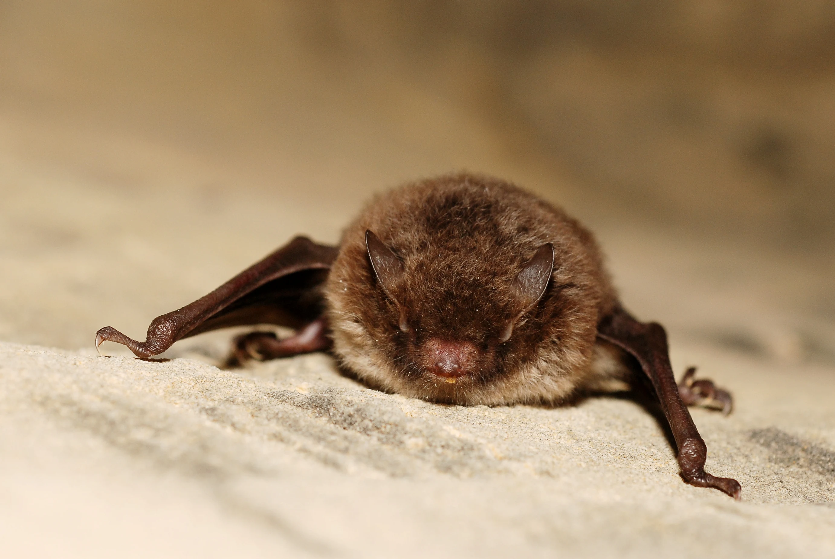
A small brown bat with fur and folded wings resting on a light-colored, textured stone surface.
A Daubenton's bat resting on a stone surface, typical of its cave habitats in the Vallée de la Tude.

Vallée de la Tude history and protected-area timeline

Vallée de la Tude does not have a long history as a discrete protected reserve. Rather, it entered the formal conservation system through France's implementation of the European Union's Natura 2000 network, which built on the earlier Birds Directive and Habitats Directive of the European Union.

The site was scientifically inventoried during the national consultation process that identified French areas of European importance for threatened species. It was then formally designated as a Special Area of Conservation, with the designation validated by an order of the French Ministry of Ecology and Sustainable Development dated 9 August 2006. Before and since that designation, the valley has continued to function as a working agricultural landscape, with conservation efforts relying on voluntary measures and habitat management agreements with local landowners and farmers rather than on full landscape expropriation.

Vallée de la Tude landscape and geographic character

The landscape of Vallée de la Tude is shaped by the Tude river and a network of small headwater streams that flow through a gently rolling section of southwestern France. Elevation varies modestly across the site, from around 25 meters above sea level along the lowest stretches of the valley floor to about 150 meters on the surrounding hillslopes, giving the protected area a relatively shallow but varied cross-section.

Most of the site consists of semi-natural wet meadows and improved mesophilic grasslands, which together occupy the largest single share of land cover. Arable fields and small areas of urban and industrial land form a substantial secondary component, reflecting the long-standing agricultural use of the valley. Scattered fragments of broadleaf deciduous woodland and small monoculture plantations complete the landscape mosaic.

The hydrography is central to the site's character. Beyond the main Tude channel, the site includes several named tributaries in the headwaters of the catchment, including the Eau Morte, the Étang Gouyat also called the Ribéral, the Gace, the Gaveronne also called la Planche, the Landuraud, and the Velonde. These small streams together create the wet meadows, marshy edges, and riparian corridors that define the valley visually and ecologically.
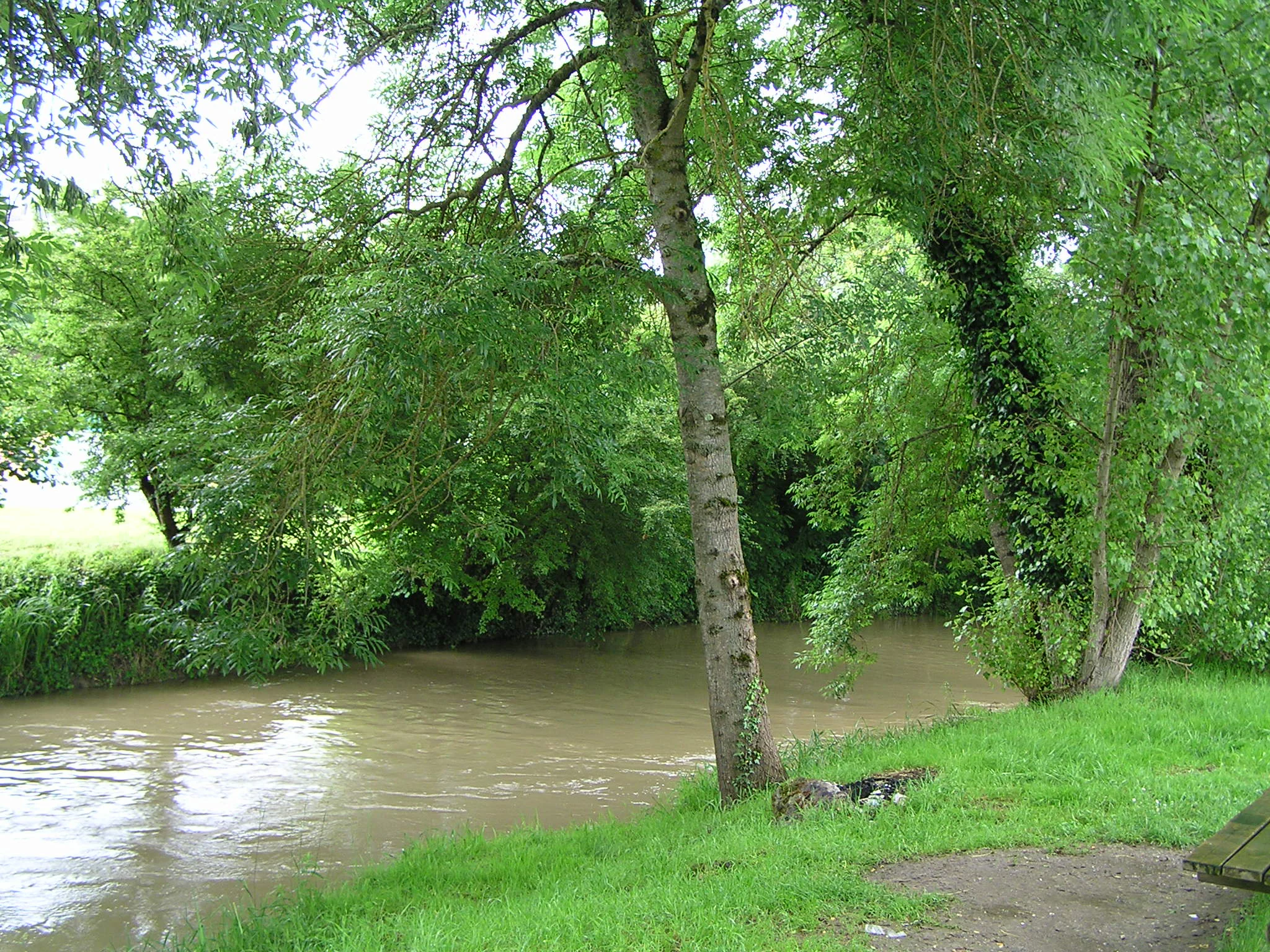
A view of a brown river flowing through a forested riverbank with green trees and grassy terrain.
The Tude River flowing through a shaded, verdant section of the valley in Chalais.

Vallée de la Tude ecosystems, habitats, and plant life

Ecologically, Vallée de la Tude is best understood as a lowland alluvial system in a heavily cultivated part of France. The site is fundamentally a mosaic of habitats whose value lies as much in their continuity and connection along the river as in any single habitat block.

Wet meadows and improved grasslands dominate the valley floor, providing open conditions that support amphibians, dragonflies, meadow butterflies, and ground-nesting birds. Small patches of broadleaf deciduous forest and artificial monoculture woodland occupy the slopes and edges, offering seasonal shelter, roosting sites for bats, and structural diversity. Arable land and built-up areas are integral parts of the mosaic rather than separate from it, with field margins, hedgerows, and old channels providing important complementary habitat.

The river and its tributaries are the connective tissue of the site. Slow-moving stretches, side channels, and wet depressions sustain freshwater species such as the white-clawed crayfish, the bullhead, and the brook lamprey, while the broader wet valley supports wetland-dependent mammals such as the European mink and the European otter. The juxtaposition of wet valley floor and drier cultivated slopes creates transition zones that are particularly rich in invertebrates and amphibians.

Vallée de la Tude wildlife and species highlights

Wildlife is the central reason for Vallée de la Tude's protected status. Sixteen animal species listed under Annex II of the European Habitats Directive have been recorded on the site, and another twenty-six species of conservation interest have also been documented.

Among Annex II species, the valley is especially important for freshwater and riparian mammals. The European mink, one of the most endangered carnivores in Europe, is found here within a recognized corridor linking the Charente and Garonne basins. The European otter also occurs in the river and tributaries, alongside smaller freshwater species such as the white-clawed crayfish, the bullhead, and the brook lamprey. The site also supports three bat species of European conservation interest, the western barbastelle, Geoffroy's bat, and the lesser horseshoe bat, together with the yellow-bellied toad and the European pond turtle, and a notable group of insects including the mercury damselfly, the stag beetle, the orange-spotted emerald, the large copper, the marsh fritillary, and the Grouville dragonfly.

Beyond Annex II species, the valley hosts additional amphibians such as the midwife toad, the agile frog, the pool frog, the Mediterranean tree frog, and the marbled newt. Its bat community is even richer at the local level, with species including the whiskered bat, Daubenton's bat, the common noctule, Leisler's noctule, the common pipistrelle, Kuhl's pipistrelle, and the serotine bat. Birds recorded in the site include the wood lark, the European honey buzzard, three species of harrier, the European nightjar, the common crane, the European kingfisher, both black and red kites, the red-backed shrike, and the tawny pipit, suggesting that the mosaic of meadows, watercourses, and woodland edges supports both resident and migratory species across the year.

Vallée de la Tude conservation status and protection priorities

Conservation at Vallée de la Tude operates within the European Natura 2000 framework, a network of protected sites created to ensure the long-term survival of Europe's most threatened habitats and species. Following inventory and consultation work, the valley was formally confirmed as a Special Area of Conservation under the EU Habitats Directive, a status that carries obligations for the maintenance or restoration of favorable conservation status for its qualifying species.

The principal conservation value of the site is its function as a stepping stone for freshwater and wetland-dependent species between the Charente and Garonne river basins. The European mink in particular relies on networks of suitable habitat along lowland rivers, and the Tude valley provides one such link in southwestern France. Suitable conditions for the species depend on maintaining wet margins, quiet stretches of water, and a prey base of small fish, amphibians, and crayfish, all of which the valley currently supports.

Beyond this corridor function, the site contributes to broader biodiversity conservation in Nouvelle-Aquitaine by sustaining viable populations of bats, amphibians, dragonflies, marshland butterflies, and farmland birds in an otherwise heavily cultivated region. Because much of the area is privately owned and actively farmed, conservation outcomes depend heavily on cooperation with local landowners and municipalities, and on the maintenance of the small-scale habitat mosaic that gives the valley its ecological coherence.

Vallée de la Tude cultural meaning and human context

The cultural context of Vallée de la Tude is rooted in its place within the rural Charente, a region characterized by small market towns, dispersed hamlets, and a long tradition of mixed farming along the Tude and Charente valleys. The communes through which the protected site extends, including Chalais, Montmoreau, Boisné-La Tude, and Montboyer, have agricultural landscapes shaped by centuries of cultivation, grazing, and local river management.

The valley's recent administrative history is itself a reflection of rural restructuring in France. Several of the communes partially covered by the protected area, including Charmant, Chavenat, and Juillaguet, were merged into the new commune of Boisné-La Tude in 2016, while Aignes-et-Puypéroux, Montmoreau-Saint-Cybard, Saint-Amant-de-Montmoreau, and Saint-Laurent-de-Belzagot joined the new commune of Montmoreau in 2017. These mergers did not change the ecological coherence of the valley but reflect the broader pattern of rural demographic and administrative change in southwestern France.

The Tude itself has long been part of the local cultural landscape. Small villages such as Chalais and Montmoreau have grown up along its course, and the surrounding meadows and hedgerows have historically supported both livestock grazing and small-scale crop production. Today, the protected status of the valley adds a new layer to this long-standing relationship between people and the river, framing the working landscape as part of a wider European conservation effort.

Top sights and standout views in Vallée de la Tude

Vallée de la Tude is a small but ecologically rich Natura 2000 valley that links the Charente and Garonne basins for freshwater wildlife in southwestern France. It is distinguished by the unusually dense concentration of Annex II species recorded within its modest 15-square-kilometer footprint, ranging from the European mink and the European otter to rare dragonflies, amphibians, and cave-roosting bats.

The site's particular value lies in the way it maintains a connected network of wet meadows, slow-moving brooks, and broadleaf woodland fragments within an intensively farmed rural landscape. Its combination of European-level mammal conservation interest, a diverse bat community, and an exceptionally varied invertebrate fauna makes it a noteworthy example of lowland alluvial conservation in the Nouvelle-Aquitaine region.

Best time to visit Vallée de la Tude

Because Vallée de la Tude is a working rural valley rather than a heavily visited park, seasonal experience is shaped mainly by the rhythms of the agricultural landscape and the life cycles of its wildlife. Spring and early summer are typically the most active period for amphibians, dragonflies, and meadow butterflies, when wet meadows come into growth and the tributaries carry higher flows. Late spring through early summer is also a rewarding period for birdwatching, with breeding raptors and migratory species active around the wooded edges and meadows.

Autumn and winter bring quieter conditions, with lower water levels in the tributaries and a more subdued atmosphere along the valley floor. These seasons can suit visitors interested in riparian scenery, the structure of the bare hedgerows and woodland edges, or simply a calmer view of the rural Charente landscape. As with any Natura 2000 site, visitors should respect local property, farming activity, and any specific guidance provided by site managers.
Monthly climate preview

Trace long-term representative temperature ranges and monthly precipitation averages across the landscape

Vallée de la Tude Climate Normals: Measured Annual Temperature and Precipitation Rhythm

Representative coordinate records for Vallée de la Tude demonstrate a measured annual rhythm ranging from winter minimums near negative four degrees Celsius to summer maximums exceeding thirty-six degrees Celsius with steady precipitation throughout the year. Reviewing the complete twelve-month climate profile provides detailed monthly temperature bounds and precipitation data for deeper geographical analysis.
Annual mean13 °C
5 °C22 °C
Jan
Feb
Mar
Apr11°
May15°
Jun19°
Jul21°
Aug22°
Sep18°
Oct13°
Nov
Dec
Warmest month
August

21.7 °C

Coolest month
January

4.8 °C

Wettest month
November

3 mm/day

Driest month
July

1.6 mm/day

Park location guide

Geography guide, regional context, and park location map for Vallée de la Tude

Vallée de la Tude park geography, regions, and map view in France

Understand where Vallée de la Tude sits in France through a broader geographic reading of the surrounding landscape, nearby location context, and its mapped position within the national park landscape.

How Vallée de la Tude fits into France

France is a unitary semi-presidential republic and one of the world's largest economies. It borders Belgium, Luxembourg, Germany, Switzerland, Italy, Monaco, Andorra, and Spain, with a maritime border to the United Kingdom. The country is known for its cultural influence, art, cuisine, and political history spanning centuries.

Wider geography shaping Vallée de la Tude in France

France is located in Western Europe. Metropolitan France extends from the Rhine to the Atlantic Ocean and from the Mediterranean Sea to the English Channel and North Sea. The country borders Belgium, Luxembourg, Germany, Switzerland, Italy, Monaco, Andorra, Spain, and has a maritime border with the United Kingdom.

Map view of Vallée de la Tude

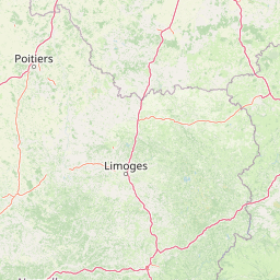
Use this park location map to pinpoint Vallée de la Tude in France, understand its exact geographic position, and read its mapped placement within the surrounding landscape more clearly.

Pigeon | © OpenStreetMap contributors

Location context for Vallée de la Tude

Nouvelle-Aquitaine
Recorded earthquake history

Review the Historical Earthquake Catalogue for Vallée de la Tude

Explore the structured record of seismic events associated by distance with the Vallée de la Tude. MoriAtlas provides this factual catalogue to assist in understanding the history of recorded tremors near this important French alluvial corridor and protected riparian habitat.

Vallée de la Tude Earthquake History

Catalogued events

11 events

Strongest magnitude

Magnitude 4.5

Most recent event

Apr 6, 2019

This history includes earthquakes recorded inside the park or within 50 km of its borders

Visual reference collection showcasing alluvial wet meadows, river corridors, and lowland habitats.

Vallée de la Tude Photos, Landscape Scenery, and Protected River Valley Views

Visual records capture the intimate topography, winding stream channels, and diverse biological habitats defining Vallée de la Tude. Studying these landscape views reveals how agricultural mosaics and protected wetlands interact across the river catchment.

A small brown bat with fur and folded wings resting on a light-colored, textured stone surface.

A view of the Tude River from a stone bridge featuring a decorative metal railing, a hanging flower basket, and a wrought-iron lamp post in the foreground.

A view of a brown river flowing through a forested riverbank with green trees and grassy terrain.

Park atlas

Compare surrounding river valleys, wetland reserves, and connected lowland habitats

Parks Near Vallée de la Tude and Related Protected Areas in Southwestern France

Browse protected areas and river valley reserves located near Vallée de la Tude to examine broader ecological corridors across Nouvelle-Aquitaine. Comparing adjacent conservation landscapes reveals shared lowland river habitats and regional biodiversity networks.
Nature reserveNouvelle-Aquitaine
3.9 km away#1 closest

Northeast

Vallée de la Nizonne Nature Reserve: Mapped Geography and Protected Wetland Landscapes

A critical river corridor and Natura 2000 conservation zone in Nouvelle-Aquitaine.

Discover the geographic structure of the Vallée de la Nizonne, a protected area shaped by the flow of the Nizonne and Lizonne rivers. This landscape mosaic features peatlands, wet meadows, and alluvial forests that serve as a refuge for rare species. Gain insight into the regional terrain and conservation boundaries that define this important French wetland corridor.

Area
33.91 km²
Established
2016
Relief
Upland
Climate
Temperate
Nature reserveCharente
31 km away#2 closest

Northeast

Val de Tardoire Nature Reserve: Geography and Protected Area Mapping in Charente

A detailed river valley landscape in Nouvelle-Aquitaine, France.

This protected area centers on the Tardoire river valley, featuring a high density of wet meadows, broadleaf forests, and rocky escarpments. The site represents a crucial node for European-interest habitats and diverse fauna, offering an in-depth look at the natural terrain and ecological composition of the Charente department.

Area
31.49 km²
Established
1999
Relief
Upland
Climate
Temperate
Nature reserveNouvelle-Aquitaine
About 35 km away#3 closest

Northeast

Réserve naturelle régionale de la vallée de la Renaudie Protected Landscape and Map Atlas

A geological crossroads in the heart of Nouvelle-Aquitaine.

Trace the 6 kilometer stretch of the Réserve naturelle régionale de la vallée de la Renaudie. This protected area showcases an unusual geological interface between limestone and granite, creating a compact mosaic of riparian woodland, dry rocky cliffs, and meadows that support significant regional biodiversity.

Area
0.73 km²
Established
2012
IUCN
IV
Relief
Mixed relief
Nature reserveNouvelle-Aquitaine
46 km away#4 closest

Northwest

Vallée de l'Antenne: A Protected River Valley and Alluvial Landscape in Nouvelle-Aquitaine

Mapping riparian ecosystems and rare wetland habitats

Trace the course of the Antenne river as it meanders through a finely textured mosaic of ash and alder forests, poplar plantations, and floodplains. As a designated Natura 2000 site, this nature reserve acts as a critical refuge for biodiversity in western France, offering a textbook example of a low-energy river system that descends gently through the landscape of the Charente departments.

Area
12.08 km²
Established
1999
Relief
Lowland
Climate
Mediterranean
Wildlife reserveNouvelle-Aquitaine
About 50 km away#5 closest

West

Terres d'oiseaux Wildlife Reserve: Protected Estuarine Landscape in Nouvelle-Aquitaine

Migratory bird habitat and Gironde estuary geography

Terres d'oiseaux is a significant wildlife reserve positioned within the Blayais marshes of Nouvelle-Aquitaine. The site encompasses a diverse mosaic of estuarine wetlands, including reedbeds and open water, providing critical stopover habitat for migratory birds along the Atlantic flyway. Its geography represents a blend of tidal interaction and controlled natural management, essential for regional avian monitoring and ecological studies.

Area
1.2 km²
Established
2010
IUCN
IV
Relief
Lowland
Nature reserveNouvelle-Aquitaine
About 68 km away#6 closest

Northeast

Réserve naturelle régionale du réseau de landes atlantiques du Parc naturel régional Périgord-Limousin

A networked regional nature reserve in Nouvelle-Aquitaine.

This protected area serves as a critical network of Atlantic heathland sites embedded within the larger Périgord-Limousin Regional Natural Park. By conserving these scattered clearings of acidic soil and low vegetation, the reserve maintains a distinct biogeographic feature far from the French coast, offering a clear view into how regional authorities manage fragmented open habitats in the Haute-Vienne.

Area
0.409 km²
Established
2015
IUCN
IV
Scope
Terrestrial
Nature reserveNouvelle-Aquitaine
About 76 km away#7 closest

Southwest

Réserve naturelle nationale géologique de Saucats et la Brède: Geological Nature Reserve Atlas

Protected strata and Miocene fossil landscapes in Nouvelle-Aquitaine

This protected area serves as a primary European reference site for Cenozoic geology. It features distinct Miocene marine sand outcrops, fossil-rich faluns, and stream-cut sections that reveal the complex history of the Aquitaine Basin across multiple geographic sectors.

Area
0.755 km²
Established
1982
IUCN
III
Nature reserveNouvelle-Aquitaine
About 89 km away#8 closest

Northwest

Réserve naturelle régionale de la Massonne: Geographic Atlas and Protected Area Map

Mapped ecosystems within the Nouvelle-Aquitaine marshlands

Réserve naturelle régionale de la Massonne serves as a significant ecological corridor in western France, defined by its abrupt transition from coastal Brouage marshes to acidic heath. This atlas entry provides essential data on the reserve boundaries, mapped terrain types, and the structural diversity of its protected wetlands and shrublands, highlighting its role as a sanctuary for diverse nocturnal fauna.

Area
2.023 km²
Established
1997
IUCN
IV
Relief
Lowland

Common questions about visiting, size, designation, and location context for Vallée de la Tude

Vallée de la Tude FAQs for park facts, access, geography, and protected area context

Find quick answers about Vallée de la Tude, including protected-area facts, park geography, trail and visitor context, and how the park fits into its surrounding country and regional landscape.
MoriAtlas Explorer

Continue Your Protected Areas Search Across the Global Atlas

Deepen your exploration by continuing the structured search for national parks and protected areas worldwide. Utilize the comprehensive filtering capabilities to compare different conservation landscapes and refine your understanding of global park geography. Discover more about the distribution and characteristics of protected natural areas.

Global natural geography