Mori Atlas logo
Natural monumentVáňův kámen

A study of pyramid-shaped limestone outcrops, archaeological history, and regional forest ecology within the Moravian-Silesian landscape.

Váňův kámen: Exploring the Geomorphology of a Distinctive Natural Monument in the Sub-Beskydy Hills

Váňův kámen stands as a prominent natural monument rising above the gentle terrain of the Podbeskydská pahorkatina in the Czech Republic. This protected site centers on a 20-meter vertical Jurassic limestone outcrop known for rich coral reef fossils and historical breccia textures. Beyond its geological status, the area integrates a dense mosaic of oak-hornbeam forest, ancient archaeological findings, and cultural memorials that define the character of the southeastern slopes of Bílá hora.

limestone outcropJurassic limestonegeological monumentnatural monumentSub-Beskydy hillsPodbeskydská pahorkatina

Váňův kámen

Natural monument

Park overview

Structured park overview, official facts, and landscape profile for Váňův kámen

Váňův kámen park facts, protected area profile, and essential visitor context

Review the core facts for Váňův kámen, including designation, size, terrain, visitor scale, habitats, and operating context in one park-focused overview.

About Váňův kámen

Váňův kámen is a protected natural monument in the northeastern Czech Republic, situated in the Moravian-Silesian Region near the town of Kopřivnice. Although it covers only a fraction of a hectare, the site draws its significance from a single, visually arresting geological feature: a near-vertical pyramid of Jurassic limestone that breaks the line of the surrounding Sub-Beskydy hills. The protected area sits on the southeastern slope of Bílá hora, within a small wooded grove that includes a notable share of young oak-hornbeam forest.

The outcrop itself is composed of light-gray Štramberk limestone, famous in Czech geological circles for its pronounced breccia structure. This limestone is rich in fossils of an ancient Jurassic coral reef, making the site important from both a geomorphological and a paleontological perspective. The faces of the rock were additionally shaped by historical limestone quarrying in the late 19th century, which is part of why the structure appears so sharply defined today.

Beyond its geological character, Váňův kámen has a notable human history. The surrounding locality is an important archaeological site where Karel Jaroslav Maška documented Bronze Age artifacts in 1879 and where traces of the Púchov culture have since been confirmed. The rock itself also marks a historical episode: peasant uprisings in the 17th century on the bishop's Hukvaldy estate, commemorated by a bronze plaque unveiled in 1995 on the southeastern face of the stone.

The site is integrated into the regional trail network. Visitors can reach the rock along the blue hiking trail and the Lašská nature trail from the square in Kopřivnice, and from there continue toward Štramberk or, via a branch of the nature trail, ascend Bílá hora to its lookout tower.

Quick facts and research context for Váňův kámen

Váňův kámen is classified as a přírodní památka (natural monument), an IUCN Category III protected area, and was officially designated on December 17, 1993, by the Okresní úřad Nový Jičín and is now administered by the Regional Authority of the Moravian-Silesian Region. The site lies on the southeastern slope of Bílá hora near Kopřivnice in the Podbeskydská pahorkatina, part of the Outer Western Carpathians subprovince, at an elevation between roughly 416 and 448 meters.

The protected zone is tiny, only 0.78 hectares, but its defining feature is a dramatic limestone outcrop about 50 by 30 meters at the base, rising as a near-vertical pyramid roughly 20 meters above the surrounding land. The rock is composed of light-gray Štramberk Jurassic limestone with a pronounced breccia texture and contains fossil remains of an ancient coral reef, giving the site both geomorphological and paleontological significance.

Protection and recognition

Terrestrial conservation scope and official designation records for Váňův kámen

Váňův kámen Protection Status and Documented Conservation Context

Váňův kámen maintains a documented terrestrial protection scope within the regional conservation network. Structured records outline the governing designation history and available international recognition sources for the terrain.

Protection details

Protection scope
Terrestrial
Transboundary protection
No
Park context

Deeper park guide and search-rich context for Váňův kámen

Váňův kámen history, landscape, wildlife, and travel context

Explore Váňův kámen through its history, landscape character, ecosystems, wildlife, conservation priorities, cultural context, and seasonal travel timing in a structured park guide built for atlas discovery and search intent.

Why Váňův kámen stands out

Váňův kámen is best known for its prominent pyramid-shaped Jurassic limestone outcrop, a conspicuous rock feature standing roughly 20 meters tall in an otherwise hilly, forested landscape. The rock is composed of Štramberk limestone with a distinctive breccia texture and is geologically important for its fossilized Jurassic coral reef fauna. Equally distinctive is the site's layered cultural significance. Archaeological finds in the area include Bronze Age artifacts discovered by Karel Jaroslav Maška in 1879, along with evidence of the Púchov culture, and the rock itself carries a memorial plaque marking the peasant uprisings of the 17th century on the Hukvaldy bishop's estate. The combination of geological monument, archaeological site, historical landmark, and popular local climbing wall gives the small protected area an unusually rich identity.
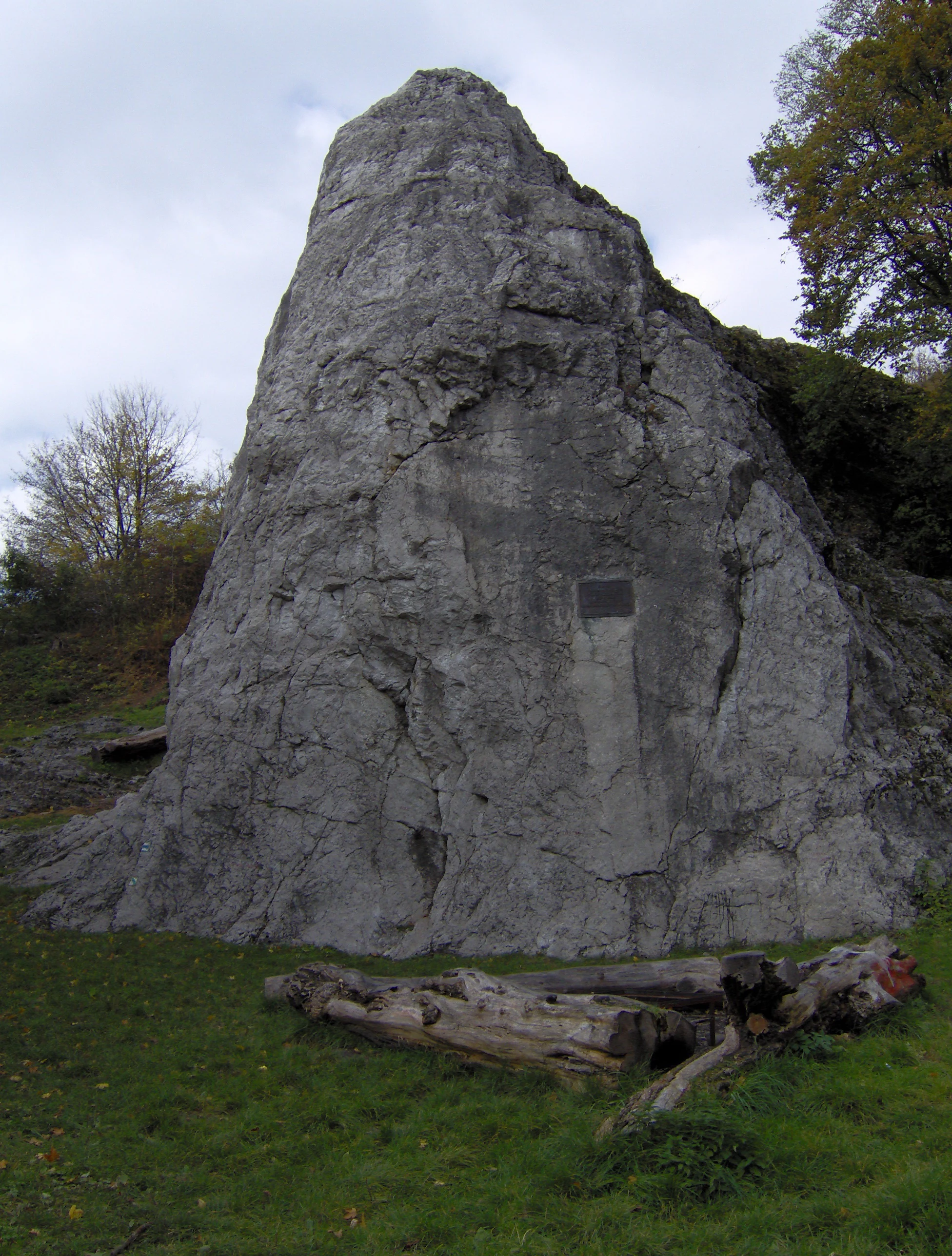
A large, weathered gray limestone rock tower rising from a grassy clearing, with trees in the background.
The Váňův kámen limestone rock formation in the Moravian-Silesian Region.

Váňův kámen history and protected-area timeline

Váňův kámen and its immediate surroundings carry a layered historical character that goes well beyond the relatively recent designation of the protected area. Archaeological research in the locality has confirmed human presence reaching back into prehistory. In 1879, the prominent Czech archaeologist Karel Jaroslav Maška carried out work on the site and recovered Bronze Age artifacts, including bronze pins and flint knives. Later archaeological investigation documented traces of the Púchov culture, a prehistoric population associated with the broader region of the western Carpathians.

The early modern history of the area is marked by social conflict. In the 17th century, peasant uprisings shook the Hukvaldy bishop's estate, a large domain that included numerous villages in the region. At their height, these uprisings reportedly drew as many as 1,500 men from approximately 30 communities. To mark this dramatic episode, a bronze memorial plaque was unveiled on the southeastern wall of the rock in 1995, transforming the natural monument into a deliberate site of historical memory as well.

The limestone of the rock itself has its own industrial history. Stone quarrying took place at the site in the late 19th century, and it was this extraction activity that altered the faces of the cliff, contributing to the steep, sharply walled profile visible today. The natural monument itself was formally designated on December 17, 1993, by the Okresní úřad Nový Jičín, and its administration later passed to the Regional Authority of the Moravian-Silesian Region.

Váňův kámen landscape and geographic character

The protected area lies within the Podbeskydská pahorkatina, the Sub-Beskydy Hills, a geomorphological subunit of the Outer Western Carpathians. This is a landscape of rolling, forested hills rather than dramatic mountains, and Váňův kámen stands out precisely because it breaks that gentle topography with a sharp, near-vertical limestone feature.

The dominant landform is a pyramid-shaped rock outcrop with a roughly triangular footprint at its base, measuring approximately 50 by 30 meters. It rises about 20 meters above the surrounding terrain, with steep cliff faces that were accentuated by historical quarrying in the late 19th century. The rock is partially set within a small wooded grove, a remízek that occupies about half the protected area with young oak-hornbeam forest, giving the site a sheltered, enclosed quality despite its visual prominence.

The wider landscape setting on the southeastern slope of Bílá hora offers broader regional context. From the rock, the terrain continues toward Štramberk and the higher ground of Bílá hora itself, linking the small monument to the larger network of Sub-Beskydy hills and the well-known town of Kopřivnice below.

Váňův kámen ecosystems, habitats, and plant life

The natural environment of Váňův kámen is defined less by species richness than by a striking juxtaposition of rock and forest in a compact space. The protected rock sits within a small grove of young oak-hornbeam forest (dubohabřina), a habitat characteristic of warm, low-lying slopes in the western Carpathian foothills. Roughly half of the protected area is covered by this young deciduous woodland, which frames the limestone outcrop and stabilizes the surrounding slope.

The cliff itself supports its own microhabitats, with crevices, ledges, and exposed limestone surfaces that host specialized rock-dwelling vegetation. The exposure of the Jurassic limestone, with its breccia texture, also creates thin, calcium-rich soils in the immediate vicinity, supporting flora that differs subtly from the surrounding more acidic forest soils. While the protected zone is small, the combination of shaded forest, open rock, and varied micro-relief gives it a noticeably layered ecological character within the Sub-Beskydy landscape.

Váňův kámen conservation status and protection priorities

The conservation significance of Váňův kámen centers on protecting a single, exceptional geological feature: a prominent outcrop of light-gray Štramberk Jurassic limestone with a distinctive breccia structure. The site is important from a geomorphological standpoint because of its unusual pyramid-like form, rising as a near-vertical feature in an otherwise rolling landscape, and from a paleontological standpoint because the limestone preserves abundant fossils of an ancient Jurassic coral reef.

Formally designated on December 17, 1993, the site is classified as a přírodní památka, a natural monument corresponding to IUCN Category III. Despite its very small area of only 0.78 hectares, the protection is targeted and deliberate, aimed at preserving both the rock itself and the surrounding oak-hornbeam grove on the southeastern slope of Bílá hora. The protected area is administered by the Regional Authority of the Moravian-Silesian Region, reflecting its recognition as a regionally significant natural monument.

Váňův kámen cultural meaning and human context

The cultural context of Váňův kámen is unusually rich for such a small protected area. The locality has been studied archaeologically since the late 19th century, when Karel Jaroslav Maška conducted excavations in 1879 and recovered Bronze Age artifacts, including bronze pins and flint knives. Subsequent research identified further evidence of the prehistoric Púchov culture, linking the site to the broader archaeological heritage of the western Carpathian region.

The name of the rock and the surrounding landscape also carry a strong regional identity tied to the Lašsko area, a historical region in northeastern Moravia. The site lies along the Lašská nature trail, a cultural and educational route that connects the region's natural landmarks with its folklore and history. The most visible cultural element at the rock itself is the bronze memorial plaque unveiled in 1995 on the southeastern cliff face, commemorating the 17th-century peasant uprisings on the Hukvaldy bishop's estate, an event reportedly involving up to 1,500 people from around 30 villages. Together, these layers give the rock a meaning that extends well beyond its geological interest.

Top sights and standout views in Váňův kámen

The single most distinctive feature of Váňův kámen is a steep, pyramid-shaped Jurassic limestone outcrop that rises roughly 20 meters above the surrounding hills of the Sub-Beskydy region. Composed of Štramberk limestone with a pronounced breccia texture and rich in coral reef fossils, the rock is both a geomorphological curiosity and a small paleontological site of regional importance.

Surrounding the rock is a modest grove of young oak-hornbeam forest on the southeastern slope of Bílá hora, and the protected area as a whole integrates a geological monument, an archaeological site, a memorial to 17th-century peasant uprisings, and a popular local climbing wall with around 22 marked routes. Its combination of natural and cultural layers in just 0.78 hectares makes it a particularly dense and rewarding stop along the Lašská nature trail from Kopřivnice.

Best time to visit Váňův kámen

The site is accessible year-round along the blue hiking trail and the Lašská nature trail from Kopřivnice, and the relatively gentle Sub-Beskydy hills do not impose strong seasonal restrictions. Spring and early summer tend to be especially appealing, when the young oak-hornbeam forest around the rock is in fresh leaf and the trail network is at its most pleasant for walking. Autumn brings colorful foliage into the small grove around the outcrop, while winter can highlight the stark shape of the limestone pyramid against bare branches, though visitors should expect potentially slippery conditions on the approach paths and on the rock itself.


Monthly climate preview

Long-term monthly temperature averages and precipitation rhythms for Moravskoslezský kraj

Váňův kámen Climate Normals and Measured Annual Temperature Patterns

Representative coordinate records show measured monthly temperature and precipitation normals spanning sub-zero winter minimums to warm summer peaks across the protected terrain. Analyzing the full twelve-month sequence reveals detailed weather variations and multi-year climate baselines for the protected landscape.
Annual mean7 °C
-4 °C19 °C
Jan-4°
Feb-3°
Mar
Apr
May13°
Jun16°
Jul19°
Aug19°
Sep13°
Oct
Nov
Dec-3°
Warmest month
July

18.6 °C

Coolest month
January

-4.1 °C

Wettest month
July

3.4 mm/day

Driest month
January

1.6 mm/day

Park location guide

Geography guide, regional context, and park location map for Váňův kámen

Váňův kámen park geography, regions, and map view in Czechia

Understand where Váňův kámen sits in Czechia through a broader geographic reading of the surrounding landscape, nearby location context, and its mapped position within the national park landscape.

How Váňův kámen fits into Czechia

Czech Republic is a landlocked Central European country with a population of approximately 10.9 million people. The nation was established as an independent state on January 1, 1993, following the dissolution of Czechoslovakia. Its capital and largest city is Prague, with other major urban centers including Brno, Ostrava, Plzeň, and Liberec.

Wider geography shaping Váňův kámen in Czechia

The Czech Republic is a landlocked country in Central Europe. It is bordered by Germany to the west, Austria to the south, Poland to the northeast, and Slovakia to the southeast. The landscape is predominantly hilly, with the territory covering 78,871 square kilometers.

Map view of Váňův kámen

Use this park location map to pinpoint Váňův kámen in Czechia, understand its exact geographic position, and read its mapped placement within the surrounding landscape more clearly.

Pigeon | © OpenStreetMap contributors

Location context for Váňův kámen

Moravskoslezský kraj

Explore detailed imagery of the prominent rock formation, wooded slopes, and regional Sub-Beskydy terrain.

Váňův kámen Photos and Landscape Scenery: Visualizing the Protected Limestone Outcrop

Visual documentation captures the steep limestone outcrop and surrounding oak-hornbeam forest of Váňův kámen in striking detail. Photographic records provide clear insight into the distinct geological features and protected landscape character of the region.

A large, weathered gray limestone rock tower rising from a grassy clearing, with trees in the background.

Park atlas

Compare regional geology, connected protected landscapes, and neighboring natural monuments.

Exploring Other Parks Near Váňův Kámen and Protected Areas in the Surrounding Region

Continue geographic discovery by comparing Váňův kámen with other protected areas and geological monuments across the surrounding hills. Browsing adjacent natural reserves helps trace the broader regional topography, linking isolated limestone outcrops to wider conservation networks.
Natural monumentMoravskoslezský kraj
About 7.1 km away#1 closest

South

Velký kámen: A Geological Natural Monument in the Moravskoslezský kraj Landscape

Sandstone cliffs and slope deformation in the western Carpathians.

Velký kámen offers a precise window into the flysch geology of the western Carpathians. The site features a defined sandstone cliff and extensive boulder debris, integrated with a natural forest fragment that showcases the biodiversity and terrain evolution characteristic of the Radhošťská hornatina highlands.

Area
0.036 km²
Established
1999
IUCN
III
Relief
Mountain
A horizontal watercolor illustration of a river landscape with lush green banks and rolling purple hills in the background against a white background.
Natural monumentMoravskoslezský kraj
About 16 km away#2 closest

West

Meandry Staré Odry: Geography of a Protected Natural Monument in Moravian-Silesian Region

Historic river meanders and floodplain riparian ecosystems

Meandry Staré Odry represents a vital conservation fragment within the Czech Republic, preserving the original meandering path of the Odra River. This natural monument is defined by quiet oxbow pools, seasonally flooded meadows, and dense riparian forests. Its geographic profile highlights the contrast between historical water dynamics and the surrounding landscape of the Moravskoslezský kraj, providing a precise look at riparian terrain.

Area
0.278 km²
Established
1999
IUCN
IV
Relief
Lowland
Natural monumentMoravskoslezský kraj
About 21 km away#3 closest

East

Vodopády Satiny Natural Monument: Mapped Geography and Protected Carpathian Landscapes

Regional geomorphology in the Moravskoslezský kraj

The Vodopády Satiny natural monument protects one of the most clearly exposed rock channels in the Czech Carpathians. Located in the Moravskoslezský kraj, the site demonstrates the impact of flysch geology on stream formation, where cascading waters have carved a distinct, long-exposure path through local mountain forests.

Area
0.09 km²
Established
2006
IUCN
III
Relief
Mountain
A soft watercolor illustration depicting a green, open floodplain with rows of trees under a pale, gentle sky.
Nature reserveMoravskoslezský kraj
About 23 km away#4 closest

North

Polanský les Nature Reserve: Mapped Protected Landscape and Floodplain Geography

A preserved hardwood forest relic in the Ostrava region

Polanský les maintains a critical status as a protected nature reserve, safeguarding a relic hardwood floodplain forest along the Oder River. This area is characterized by its significant botanical diversity, including established snowdrop populations and mature broadleaf woodland. Its location within the Moravskoslezský kraj highlights its role as a dense ecological fragment at the geological boundary between the Bohemian Massif and the Outer Western Carpathians.

Area
0.598 km²
Established
1970
IUCN
IV
Relief
Lowland
Natural monumentMoravskoslezský kraj
About 26 km away#5 closest

Northeast

Václavovice, pískovna Natural Monument: Mapped Geography and Protected Wetland Boundaries

Amphibian habitat and industrial site reclamation in Moravskoslezský kraj

Václavovice, pískovna represents a carefully managed natural monument where former quarrying activities have evolved into a rich mosaic of ponds, reeds, and damp woodland. Situated in the Moravian-Silesian Region, this compact site provides essential shelter for multiple amphibian species and underscores the importance of secondary natural habitats within broader regional geography.

Area
0.069 km²
Established
2013
IUCN
III
Relief
Lowland
Watercolor painting of a meandering river landscape with green grasses, shrubs, and soft pink hills in the background.
Natural monumentMoravskoslezský kraj
About 30 km away#6 closest

Northeast

Meandry Lučiny Natural Monument: Protected Riverine Geography and Floodplain Habitat Maps

Natural river meanders in the Moravian-Silesian landscape

This protected natural monument preserves a vital lowland river corridor where the Lučina River flows in an unregulated course. Through its shifting meanders and diverse floodplain habitats, the area highlights the ecological importance of maintaining natural hydrological processes in a heavily urbanized region of the Czech Republic.

Area
0.406 km²
Established
1992
IUCN
III
Relief
Lowland
Natural monumentMoravskoslezský kraj
About 31 km away#7 closest

Northwest

Vrásový soubor v Klokočůvku: Geological Structure and Protected Monument Atlas

Regional rock exposures in the Moravian-Silesian landscape.

Vrásový soubor v Klokočůvku features an exceptional exposure of folded Culm sedimentary strata known as Dračí skála. This protected monument offers a clear view of complex fold geometries and tectonic deformation, serving as a primary site for understanding the geological history of the eastern Bohemian Massif landscape.

Area
0.013 km²
Established
1998
IUCN
III
Relief
Lowland
A soft watercolor painting depicting a gentle, hazy landscape with rolling hills, scattered patches of trees, and a winding path, rendered in light green, yellow, and peach tones against a white background.
Protected landscapeCzechia
About 36 km away#8 closest

Southwest

Hostýnské vrchy Nature Park: Protected Landscape and Carpathian Foothill Geography

Forested ridge terrain across Zlín and Kroměříž districts

Hostýnské vrchy Nature Park represents a significant protected unit in the eastern Czech Republic, characterized by its deep forested ridges and open meadow clearings. As part of the outer Western Carpathians, the area supports diverse habitats including ancient beech and mixed forest stands alongside rare orchid populations. The landscape provides a clear window into the natural geography of central Moravia, with its intricate network of small watercourses and slopes.

Area
204 km²
Established
1989
Water
Minor water
Season
Year-round

Common questions about visiting, size, designation, and location context for Váňův kámen

Váňův kámen FAQs for park facts, access, geography, and protected area context

Find quick answers about Váňův kámen, including protected-area facts, park geography, trail and visitor context, and how the park fits into its surrounding country and regional landscape.
MoriAtlas Explorer

Continue Your Protected Areas Search Across the Global Atlas

Deepen your exploration by continuing the structured search for national parks and protected areas worldwide. Utilize the comprehensive filtering capabilities to compare different conservation landscapes and refine your understanding of global park geography. Discover more about the distribution and characteristics of protected natural areas.

Global natural geography