
Mori Atlas logo
Natural monumentVelký kámen

A focused study of Carpathian flysch geology, deep slope deformations, and natural forest cover.

Velký kámen: Mapping the Sandstone Outcrops and Slope Dynamics in Moravskoslezský kraj

Velký kámen stands as a significant natural monument within the Veřovické vrchy hills of the western Carpathians. This protected territory preserves a prominent Godula sandstone cliff alongside a characteristic blocky scree slope, serving as a primary reference point for slope movement and flysch geomorphology in the Moravskoslezský kraj region of the Czech Republic.

natural monumentsandstone outcropflysch geologyCarpathian foothillsslope deformationrock scree
A vibrant, flat-style digital illustration depicting a sunny forest scene with a waterfall cascading down between large, pale-colored rock formations.

Velký kámen

Natural monument

Park overview

Structured park overview, official facts, and landscape profile for Velký kámen

Velký kámen park facts, protected area profile, and essential visitor context

Review the core facts for Velký kámen, including designation, size, terrain, visitor scale, habitats, and operating context in one park-focused overview.

About Velký kámen

Velký kámen is a compact but ecologically and geologically meaningful protected area in the western Carpathian foothills of the Czech Republic, designated to preserve a single dramatic geological feature together with the natural forest that surrounds it. The name translates directly as the Big Stone, a simple local reference to the prominent rock outcrop that is the principal reason the terrain here received formal protection.

Administratively, the territory sits within the CHKO Beskydy protected landscape area, a wide buffer surrounding the core Beskydy mountains where Czech conservation authorities regulate land use and forestry to maintain ecological integrity. The monument is administered by AOPK ČR (Agentura ochrany přírody a krajiny ČR) through its regional Beskydy office, which oversees not only this site but a network of similarly small but value-dense conservation holdings across the region.

The protected feature itself is a rock wall several tens of meters long, rising from a slope of boulder-strewn debris and transitioning upward into the natural forest canopy of the hillside. It is located roughly 200 vertical meters below the summit of Velký Javorník, the highest point of the Veřovické vrchy range, and forms part of the upper slope system of the broader Radhošťská hornatina highland. Although Velký kámen is too small and too steep to attract general tourism, it remains an important reference site for understanding the interplay of Carpathian flysch geology, slope stability, and natural forest dynamics in this part of Moravia.

Quick facts and research context for Velký kámen

Velký kámen is a registered přírodní památka, a lower-tier national designation roughly comparable to a natural monument or protected geological feature, categorized as IUCN Category III. It was declared on 19 August 1999 by the administration of the CHKO Beskydy protected landscape area and is currently managed by AOPK ČR through the regional Beskydy office.

The site lies roughly 200 meters below the summit of Velký Javorník and about 1.5 km southeast of the Veřovice railway station, placing it firmly within the foothill zone of the western Carpathians. Its protected surface is small, with the listed area measuring just a few hectares and elevations ranging across the local slope belt of the hill. The monument has the central catalogue code 2061 in the Czech nature conservation register.

Protection and recognition

Terrestrial protection metrics and official designation records for Velký kámen

Velký kámen Protection Status and Documented Conservation Scope

Velký kámen maintains a documented terrestrial protection scope without imported international recognition sources. Conservation researchers evaluate management designations and official administrative records through structured protected area inventories.

Protection details

Protection scope
Terrestrial
Park context

Deeper park guide and search-rich context for Velký kámen

Velký kámen history, landscape, wildlife, and travel context

Explore Velký kámen through its history, landscape character, ecosystems, wildlife, conservation priorities, cultural context, and seasonal travel timing in a structured park guide built for atlas discovery and search intent.

Why Velký kámen stands out

Velký kámen is best known for its large sandstone exhumation, a hard rock exposure formed from Cretaceous-age Godula sandstones that are characteristic of the flysch geology of the outer western Carpathians. These rocks, locally called godulské pískovce, define many of the dramatic cliff and slide features of the Beskydy and their foothills. Beyond the rock itself, the site is notable as a textbook example of a deep-seated slope deformation source area, a place where the bedrock has detached and slid, leaving behind a characteristic detachment scarp and blocky boulder field below. This combination of stratigraphic, geomorphological, and forest values gives the small monument an unusually rich character for its size, making it a reference point in the regional catalogue of protected localities around the Veřovické vrchy.
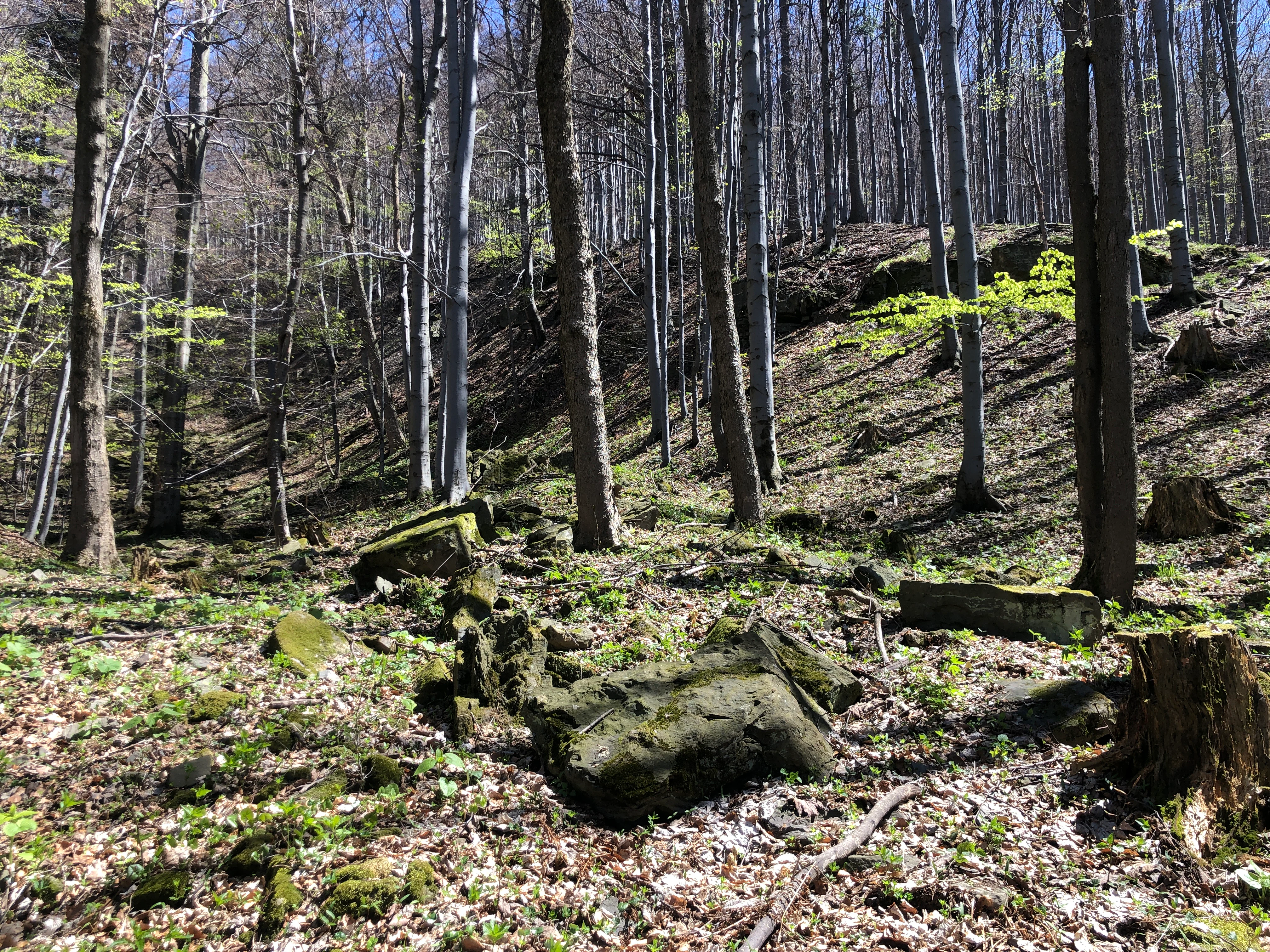
A woodland scene showing a forested hillside in spring, with large, mossy sandstone rock boulders scattered on the forest floor among tall, thin deciduous trees.
A forested slope with exposed sandstone rock formations at the Velký kámen natural monument.

Velký kámen history and protected-area timeline

Velký kámen was officially declared a přírodní památka on 19 August 1999 by the administration of the CHKO Beskydy. Its designation was driven by the recognition that the site combined a well-exposed sandstone rock face, evidence of large-scale slope movement, and a fragment of natural forest, a combination considered worth preserving on its own merits even though the protected area is small in absolute terms.

Since then, the site has remained within the administrative framework of the Czech system of small-scale protected areas, catalogued under the conservation register code 2061 and managed by the same regional office that looks after the broader Beskydy protected landscape area. Its history is effectively institutional, marking a step in the gradual build-out of the Czech Republic's network of small geological and ecological monuments in the Carpathian foothills rather than tracing a long chain of earlier designations or ownership changes.

Velký kámen landscape and geographic character

The local landscape at Velký kámen is shaped by the flysch geology of the outer western Carpathians, in which alternating layers of sandstone and weaker clay-rich rocks yield steep, irregular terrain prone to slope failure. The Veřovické vrchy hills, of which Velký Javorník is the highest point, rise above the surrounding lowlands as a ridge-and-valley system with deeply incised valleys and frequent landslide scars, and Velký kámen sits squarely within this morphology.

The protected area itself is dominated by a sandstone cliff and the rock debris that has accumulated below it. The cliff face is described as several tens of meters long and forms the most visible expression of bedrock geology in the locality. Below it, the slope is mantled by boulder field, known locally as balvanitá suť, with angular blocks dislodged from the parent cliff and now resting on the hillside at varying sizes, giving the terrain a rugged, broken character.

Above and around the cliff, the slopes carry a natural forest cover integrated with the protected rock exposure. The combination of exposed rock, boulder debris, and contiguous forest is what gives the site its compact but vivid physical character; even though the elevation range is modest, the contrast between cliff, debris slope, and tree canopy creates a small-scale dramatic relief that signals the site's broader geological significance.

Velký kámen ecosystems, habitats, and plant life

Although Velký kámen's name emphasizes the rock at its center, the protected territory also preserves a fragment of natural forest that local authorities consider unusually biodiverse for its size. The forest reaches the cliff edge and remains connected along the slope, allowing forest-floor and rock-face habitats to occur in close proximity within a very small area.

This gradient from shaded rock fissures and boulder crevices, through boulder-field openings and their specialized microhabitats, up into the closed forest canopy, creates a layered local ecology. Natural forest of this kind on flysch bedrock typically supports a mix of broadleaf species well adapted to the seasonal moisture regime of the Carpathian foothills, with rock and scree habitats adding niches for mosses, lichens, and rock-dwelling invertebrate communities.

The ecological interest of the site is therefore not a question of acres of wilderness but of structural continuity: a small but intact mosaic of rock, debris, and forest. This kind of mosaic is increasingly rare in the broader region, where most hillside forests have been modified by long-running forestry, making the remnant at Velký kámen disproportionately valuable from a biodiversity perspective.

Velký kámen conservation status and protection priorities

The principal conservation significance of Velký kámen lies in the way it bundles together geological pattern, geomorphological process, and natural forest habitat within a single compact area. The rock exposure gives the site a strong geological protection argument: it preserves an outcrop of Godula sandstone together with its structural features at the surface, materials normally hidden beneath forest cover and soil.

The boulder field and cliff together also serve as a reference example of deep-seated slope deformation source area, the upper portion of a larger slope movement system. Protecting such source zones in Carpathian flysch terrain is valuable for monitoring and understanding the dynamics of mountain slopes over time, complementing the more practical conservation of habitats and species elsewhere in the CHKO Beskydy.

A further conservation dimension comes from the natural forest fragment that surrounds the cliff. By holding back the area from forestry exploitation and keeping the forest, rock, and debris zones in a contiguous natural state, the designation protects an unusually complete micro-mosaic within the wider managed landscape of the Beskydy foothills. In this sense, Velký kámen's role is to anchor one small but representative piece of Carpathian geological and forest character within the broader Beskydy conservation framework.

Top sights and standout views in Velký kámen

Velký kámen's strongest qualities are concentrated rather than extensive. It offers an unusually clear exposure of godulský pískovec, the characteristic Godula sandstone of the western Carpathian flysch, exposed where slope movement has stripped away the cover rock. The cliff face is several tens of meters long and is paired with a boulder-strewn slope that has tumbled away from it, making the geological story of the site legible even to visitors unfamiliar with detailed Carpathian stratigraphy.

Equally important is the surrounding natural forest, which the protected territory preserves as an integrated whole with the rock. The designation's IUCN Category III status and the small hectare count reinforce that this is a focused, high-density value site: a place where a single landscape element has been protected tightly, rather than a broad territorial reserve. Adventurous visitors reaching the locality from Veřovice via the trail network around Veřovické vrchy encounter a representative cross-section of the geology and forest character of the Radhošťská hornatina in a single small stop.

Best time to visit Velký kámen

Velký kámen sits in the lower mountain belt of the western Carpathians, and the seasonal cycle here follows the broader Moravian foothill pattern rather than a high-alpine one. Late spring tends to bring out fresh green in the surrounding forest and improves the visibility of plants growing in the rock crevices and boulder openings, while early autumn offers stable weather and richly colored foliage against the gray sandstone.

Winter can subject the slope to freezing and thawing, conditions that are themselves part of the slope dynamics that define the site, although ice on the rock face and snow cover on the boulder slope make the terrain more demanding for casual visitors. Summer is generally comfortable on the slopes but, as in much of the Česko-Moravian Carpathian region, weather can turn quickly and access paths are best chosen with attention to wet conditions on the debris mantle. Because the site is managed primarily for conservation rather than recreational infrastructure, visits are most rewarding when combined with broader activity in the CHKO Beskydy landscape.


Monthly climate preview

Track representative annual temperature ranges and precipitation patterns for Velký kámen

Velký kámen Climate Normals and Long-Term Weather by Month Preview

Long-term historical measurements for Velký kámen reveal a measured annual temperature rhythm alongside consistent monthly precipitation rates across the recorded coordinate. Examining the complete twelve-month climatology dataset uncovers deeper variations in average maximum and minimum temperatures.
Annual mean7 °C
-4 °C19 °C
Jan-4°
Feb-3°
Mar
Apr
May13°
Jun16°
Jul19°
Aug19°
Sep13°
Oct
Nov
Dec-3°
Warmest month
July

18.6 °C

Coolest month
January

-4.1 °C

Wettest month
July

3.4 mm/day

Driest month
January

1.6 mm/day

Park location guide

Geography guide, regional context, and park location map for Velký kámen

Velký kámen park geography, regions, and map view in Czechia

Understand where Velký kámen sits in Czechia through a broader geographic reading of the surrounding landscape, nearby location context, and its mapped position within the national park landscape.

How Velký kámen fits into Czechia

Czech Republic is a landlocked Central European country with a population of approximately 10.9 million people. The nation was established as an independent state on January 1, 1993, following the dissolution of Czechoslovakia. Its capital and largest city is Prague, with other major urban centers including Brno, Ostrava, Plzeň, and Liberec.

Wider geography shaping Velký kámen in Czechia

The Czech Republic is a landlocked country in Central Europe. It is bordered by Germany to the west, Austria to the south, Poland to the northeast, and Slovakia to the southeast. The landscape is predominantly hilly, with the territory covering 78,871 square kilometers.

Map view of Velký kámen

Use this park location map to pinpoint Velký kámen in Czechia, understand its exact geographic position, and read its mapped placement within the surrounding landscape more clearly.

Pigeon | © OpenStreetMap contributors

Location context for Velký kámen

Moravskoslezský kraj

Visual reference guide to sandstone rock outcrops, blocky scree slopes, and forest habitats.

Velký kámen Photos and Protected Landscape Scenery in the Carpathian Foothills

Visual documentation captures the rugged sandstone cliffs, blocky boulder fields, and native forest fragments that define the protected terrain of Velký kámen. Examining these field photographs reveals the geological formations and slope deformation processes characteristic of the western Carpathian flysch zone.

A woodland scene showing a forested hillside in spring, with large, mossy sandstone rock boulders scattered on the forest floor among tall, thin deciduous trees.

Park atlas

Compare adjacent geological formations and regional protected landscapes across the highlands.

Other Parks Near Velký Kámen and Surrounding Carpathian Protected Areas

Browsing other parks near Velký kámen reveals broader geological patterns across the Carpathian flysch terrain and neighboring regional reserves. Expanding the protected-area comparison helps place local sandstone outcrops within the wider topography of the surrounding highlands.
Natural monumentMoravskoslezský kraj
About 7.1 km away#1 closest

North

Váňův kámen: Natural Monument and Jurassic Limestone Landmark in the Moravian-Silesian Region

Geological outcrops and forest terrain in the Sub-Beskydy Hills

Váňův kámen presents a sharp, pyramid-shaped Jurassic limestone formation that breaks the rolling topography of the Sub-Beskydy Hills. This 0.78-hectare protected site preserves vital evidence of prehistoric coral reefs alongside significant archaeological layers and historical markers. Its unique position as a natural, historical, and geological feature makes it a focal point for understanding the diverse landscape composition of the Czech Moravian-Silesian Region.

Area
0.008 km²
Established
1993
IUCN
III
Relief
Upland
Natural monumentMoravskoslezský kraj
About 20 km away#2 closest

East

Vodopády Satiny Natural Monument: Mapped Geography and Protected Carpathian Landscapes

Regional geomorphology in the Moravskoslezský kraj

The Vodopády Satiny natural monument protects one of the most clearly exposed rock channels in the Czech Carpathians. Located in the Moravskoslezský kraj, the site demonstrates the impact of flysch geology on stream formation, where cascading waters have carved a distinct, long-exposure path through local mountain forests.

Area
0.09 km²
Established
2006
IUCN
III
Relief
Mountain
A horizontal watercolor illustration of a river landscape with lush green banks and rolling purple hills in the background against a white background.
Natural monumentMoravskoslezský kraj
About 20 km away#3 closest

Northwest

Meandry Staré Odry: Geography of a Protected Natural Monument in Moravian-Silesian Region

Historic river meanders and floodplain riparian ecosystems

Meandry Staré Odry represents a vital conservation fragment within the Czech Republic, preserving the original meandering path of the Odra River. This natural monument is defined by quiet oxbow pools, seasonally flooded meadows, and dense riparian forests. Its geographic profile highlights the contrast between historical water dynamics and the surrounding landscape of the Moravskoslezský kraj, providing a precise look at riparian terrain.

Area
0.278 km²
Established
1999
IUCN
IV
Relief
Lowland
A soft watercolor illustration depicting a green, open floodplain with rows of trees under a pale, gentle sky.
Nature reserveMoravskoslezský kraj
About 30 km away#4 closest

North

Polanský les Nature Reserve: Mapped Protected Landscape and Floodplain Geography

A preserved hardwood forest relic in the Ostrava region

Polanský les maintains a critical status as a protected nature reserve, safeguarding a relic hardwood floodplain forest along the Oder River. This area is characterized by its significant botanical diversity, including established snowdrop populations and mature broadleaf woodland. Its location within the Moravskoslezský kraj highlights its role as a dense ecological fragment at the geological boundary between the Bohemian Massif and the Outer Western Carpathians.

Area
0.598 km²
Established
1970
IUCN
IV
Relief
Lowland
Natural monumentMoravskoslezský kraj
About 31 km away#5 closest

Northeast

Václavovice, pískovna Natural Monument: Mapped Geography and Protected Wetland Boundaries

Amphibian habitat and industrial site reclamation in Moravskoslezský kraj

Václavovice, pískovna represents a carefully managed natural monument where former quarrying activities have evolved into a rich mosaic of ponds, reeds, and damp woodland. Situated in the Moravian-Silesian Region, this compact site provides essential shelter for multiple amphibian species and underscores the importance of secondary natural habitats within broader regional geography.

Area
0.069 km²
Established
2013
IUCN
III
Relief
Lowland
A soft watercolor painting depicting a gentle, hazy landscape with rolling hills, scattered patches of trees, and a winding path, rendered in light green, yellow, and peach tones against a white background.
Protected landscapeCzechia
About 34 km away#6 closest

Southwest

Hostýnské vrchy Nature Park: Protected Landscape and Carpathian Foothill Geography

Forested ridge terrain across Zlín and Kroměříž districts

Hostýnské vrchy Nature Park represents a significant protected unit in the eastern Czech Republic, characterized by its deep forested ridges and open meadow clearings. As part of the outer Western Carpathians, the area supports diverse habitats including ancient beech and mixed forest stands alongside rare orchid populations. The landscape provides a clear window into the natural geography of central Moravia, with its intricate network of small watercourses and slopes.

Area
204 km²
Established
1989
Water
Minor water
Season
Year-round
Watercolor painting of a meandering river landscape with green grasses, shrubs, and soft pink hills in the background.
Natural monumentMoravskoslezský kraj
About 34 km away#7 closest

Northeast

Meandry Lučiny Natural Monument: Protected Riverine Geography and Floodplain Habitat Maps

Natural river meanders in the Moravian-Silesian landscape

This protected natural monument preserves a vital lowland river corridor where the Lučina River flows in an unregulated course. Through its shifting meanders and diverse floodplain habitats, the area highlights the ecological importance of maintaining natural hydrological processes in a heavily urbanized region of the Czech Republic.

Area
0.406 km²
Established
1992
IUCN
III
Relief
Lowland
Natural monumentMoravskoslezský kraj
About 36 km away#8 closest

Northwest

Vrásový soubor v Klokočůvku: Geological Structure and Protected Monument Atlas

Regional rock exposures in the Moravian-Silesian landscape.

Vrásový soubor v Klokočůvku features an exceptional exposure of folded Culm sedimentary strata known as Dračí skála. This protected monument offers a clear view of complex fold geometries and tectonic deformation, serving as a primary site for understanding the geological history of the eastern Bohemian Massif landscape.

Area
0.013 km²
Established
1998
IUCN
III
Relief
Lowland

Common questions about visiting, size, designation, and location context for Velký kámen

Velký kámen FAQs for park facts, access, geography, and protected area context

Find quick answers about Velký kámen, including protected-area facts, park geography, trail and visitor context, and how the park fits into its surrounding country and regional landscape.
MoriAtlas Explorer

Continue Your Protected Areas Search Across the Global Atlas

Deepen your exploration by continuing the structured search for national parks and protected areas worldwide. Utilize the comprehensive filtering capabilities to compare different conservation landscapes and refine your understanding of global park geography. Discover more about the distribution and characteristics of protected natural areas.

Global natural geography